Twenty-three days ago, Houston Mayor Sylvester Turner read a letter to a packed town hall meeting at the Kingwood Community Center. The letter was from a lawyer named J. Carey Gray. Mr. Gray laid out a timetable for accelerating completion of the detention ponds on the troubled Perry Homes’ development, Woodridge Village, just north of Elm Grove. The first deliverable: completing the S2 pond in 30-45 days – even though it was already largely completed.
As of early this week, contractors have performed no new excavation work on the site since early August. See pictures below.
One Piece of Equipment Moves Closer to S2 Pond
This piece of Rebel Construction equipment moved from the site entrance to north of the S2 pond last Thursday. It looks as though its in danger of actually doing some work.Photo by Jeff Miller on 11/7/2019.
Dirt Continues to Flow From Construction Site
Construction has slowed to a virtual standstill for three months. Between that time and the time the photos below were taken, we had Imelda and a 2.12-inch rain on October 29.
On the 29th, yet more mud washed out of the development into the City’s storm drains, despite the City’s Cease and Desist Letter.
This and photos immediately below were taken on 10/29/2019 near Woodridge Village Construction entrance on Fair Grove Drive and Creek Manor Drive in Kingwood.Dropping back a little farther, you can see the silty runoff from the construction site. Notice the contrast between that and the clear water coming from a resident’s lawn through the curb break.Contrast appears a little clearer in this closeup.You can see the contrast even better where the water enters this storm drain. Muddy water is coming from the construction site. Clear water from the neighborhood to the south.These sand waves covered Fair Grove Drive just outside the construction site entrance...despite silt fencing.Here’s a picture of water going into the S2 Detention pond at the north end of Village Springs Drive.And here it is coming out of S2 into Taylor Gully. S2 is behind the trees on the left. This shot is looking north.
Of course, flooding, not sediment is the real issue in Elm Grove. However, sediment can block storm drains and contribute to flooding. That’s why the City has an ordinance prohibiting discharges of sediment into the City’s sewer system. It’s one area where the City has real leverage with the Perry gang. That’s why so much emphasis has been placed on sediment in this controversy.
City Inspectors Visit Site
Thursday and again Friday, City inspectors checked the construction site for discharges. We dodged a huge bullet Thursday. Parts of Houston received five inches of rain. But the Lake Houston Area received less than one inch.
Photo taken 11/7/2019 by Jeff Miller of a City Inspector photographing Woodridge S2 detention pond.Photo taken 11/7/2019 by Jeff Miller shows same City Inspector walking along Taylor Gully just south of Woodridge.
Denials, Finger Pointing, Objections on Legal Front
Webster and Spurlock, lawyers for hundreds of Elm Grove flood victims, have brought another defendant into the suit. It is Texasite LLC of Montgomery, Texas. Legal filings do not describe exactly what the new defendant did on site. The company has no web site that I can find. Even the Texas Secretary of State can’t shed much light on the matter; the company’s Certificate of Formation simply says it is organized to “conduct lawful business.”
PSWA and Figure Four Partners, two Perry Homes subsidiaries being sued, objected to items #2 and #3 on the list. They included “letters, emails, and other correspondence/communications between LJA Engineering & Surveying” and the defendants “with regard to the Woodridge Village Development.” The defendants argued in their objection that the request was overly broad because it didn’t limit the time period or subject matter. So sayeth Counselor J. Carey Gray, who wrote the overly vague letter to the City of Houston re: completion of the detention ponds. According to documents on file with the Harris County District Clerk, the judge has not yet ruled on Perry’s objection to production of the evidence.
Delays Also Continue on Construction of More Detention
I flew over the Woodridge Village construction site on Monday, 11/4 and saw no evidence of construction activity, despite the assurances made by Counselor Gray. The images below show the lack of activity from several different angles.
Looking N at the extreme western tail of the construction site that borders Woodland Hills Drive (left).This and all photos below taken on 11/4/2019.Looking NE across the north and south sections of the site. Detention pond S1 runs along the diagonal tree line from the lower left. Detention Pond N2 is in the upper right.These two ponds comprise 23% of the total detention capacity by volume.Detention pond N3 is supposed to go along the trees in the background to the left of the S2 pond. It has not been started yet. Notice the one piece of yellow equipment at work clearcutting more land on the middle left.Close up of where the N3 pond will eventually go. It will start in the bottom left and curl around the upper right.Looking west. No construction activity on the northeast corner of the site in the foreground.From this angle, looking SW, it’s easy to see all the standing water on the site. We received two inches of rain SIX days before. So much for LJA’s assumption that this site contained sandy loam. The ponding water after such a long period suggests a high clay content. That in turn explains the rapid and huge runoff rates that flooded Elm Grove.More ponding water indicating high clay content.Looking west at the NW corner of the site. This is where the non-existent N1 pond should be.Looking North. The largest detention pond on the site, N2, will go in that triangular green area (center). Contractors were supposed to deepen and enlarge it. The partial detention capacity you see here now was developed by Montgomery County in 2006 as mitigation for another site.So the detention capacity you see in this image, by itself, would not reduce Elm Grove flooding potential.Saying it did would be like trying to sell a ticket that someone else already bought.
I’m Shocked, Shocked I Tell You
So what are we to make of the continued lack of construction activity? To paraphrase the exchange between Strasser and Renault in the movie Casablanca, I am shocked – SHOCKED – Perry would promise the Mayor of Houston that it would accelerate construction of new detention ponds and then not do it.
Posted by Bob Rehak on 11/9/2019, with photos an updates from Jeff Miller.
802 Days since Hurricane Harvey and 50 Days since Imelda
The thoughts expressed in this post represent my opinions on matters of public policy and safety. They are protected by the First Amendment of the US Constitution and the Anti-SLAPP Statute of the Great State of Texas.
https://i0.wp.com/reduceflooding.com/wp-content/uploads/2019/11/RJR_4334.jpg?fit=1500%2C1000&ssl=110001500adminadmin2019-11-09 19:33:142019-11-09 20:06:26Woodridge Village Update: More Dirt, Denials, Delays
At this point, the world knew that flood maps would soon change radically. But the LJA report contains no mention of Harvey, USGS, or NOAA’s new Atlas 14 data. And in fact…
Less than one month after the LJA Engineering hydrology report, on September 27, NOAA issued new rainfall frequency values for Texas. Called Atlas 14, the NOAA analysis established significantly higher rainfall frequency values for this part of Texas.
New updated NOAA Atlas 14 data shows that a hundred-year rain for the Lake Houston area is now defined as 17.3 inches in 24 hours, up from 12.17 inches by the old standards.
NOAA redefined the amount of rainfall it takes to qualify as a 100-year or 1000-year event. They defined the new 100-year rain as 17.3 inches in 24-hours – a 42% increase. That means that to meet new 100-year standards, Perry would have had to increase its detention capacity by 42%. Instead of 271 acre feet, it would have needed 385.
Using Atlas 14 would have reduced the number of salable lots and the economic projections for the development to a substantial degree.
The one flood map in the 59-page LJA Engineering hydrology report shows flood plains magically stopping at the county line.
National Wetlands Inventory Map shows both sections of Woodridge Village contain wetlands.
Woodridge Plans Approved Even Before LJA Submitted Hydrology Report
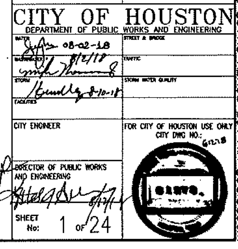
Now here’s where it gets even more interesting. City of Houston approved the detention plans on 8/12/18 – two weeks BEFORE the LJA hydrology report on 8/28/18 and only a month BEFORE NOAA released the new Atlas 14 data. Hmmmm! Think they were in a hurry to get these approved? (Note: The approval date for MoCo is unreadable).
Signature block for City of Houston from Woodridge Village detention plans.
Perry Homes played a game of beat the clock and was winning … until May 7, 2019.
Future Flood Risk Remains Even with Planned Detention Ponds
Until now, I have been posting about the lack of detention ponds. Closer analysis reveals that this is only part of the problem. Even if Perry builds the remainder of the detention ponds as planned, they will be insufficient to meet the new NOAA standards and will pose a flood risk to people downstream.
After contributing to two floods in Elm Grove and North Kingwood Forest, the engineers and owners of Woodridge Village surely must realize how dangerous trying to Beat the Clock was.
Forty-two percent of a 100-year flood as defined by the new Atlas-14 data will overflow the banks of the detention ponds and add to the load on Taylor Gully or go into the streets of Elm Grove and North Kingwood Forest.
Facing west. This panoramic drone image by Chris Betz takes in most of the Woodridge Village constructions site. Note the ponding water 3.5 days after a two-inch rain.
This image taken Friday night at Sunset shows how impervious the Woodridge soil is. Water is still ponding three and a half days after a two-inch rain (October 28, 2019).
795 Days after Hurricane Harvey and 45 after Imelda
The thoughts expressed in this post represent my opinions on matters of public policy and safety. They are protected by the First Amendment of the US Constitution and the Anti-SLAPP Statute of the great State of Texas.
https://i0.wp.com/reduceflooding.com/wp-content/uploads/2019/11/Aerial-Perry-Sml.jpg?fit=3553%2C851&ssl=18513553adminadmin2019-11-01 23:33:312019-11-03 20:13:20Woodridge Village Detention Calculations Off by More Than 40% According to New Standard
Today, we got two inches of rain between 1:30 and 3:20. That’s according to the closest official gage at US59 and the West Fork. See the graph below. Ben’s Branch came out of its banks almost immediately and nearly flooded St. Martha’s Catholic School and Kids in Action again.
Today’s Rainfall in 10-minute Increments
The closest gage at the West Fork and US59 registered a total of 2.08 inches for the event.In ten-minute increments, it looked like this.Source: HarrisCountyFWS.org.
The Result
St. Martha’s School after two inches of rain in a two hour period. This is what the parking lot of the school looked like 1.5 hours after the rain ended. The floodwaters came from Ben’s Branch which was at a virtual standstill in this area. Water under the Woodland Hills Bridge just south of Northpark Drive barely moved.
St. Martha’s has not yet finished repairs from Imelda. No floodwater actually got in the school today, but it came dangerously close for a rain that was not unusual for this area. The school is at least two feet above the hundred year flood plain and this was a one-year rain at best (see table below).
Across the creek, Heather Jensen at Kids In Action wrote, “We’re currently rebuilding Kids In Action for the second time since May. Can’t stomach a third.” Many people would agree with that!
Expect a Rainfall This Intense at Least Annually
The latest NOAA Atlas-14 rainfall chart for this area shows that we can expect a two-inch rain in two hours at least once a year. If you measure the 10-minute peak, it also works out to a one-year event. Which we’ve had several of this year.
I have lived in Kingwood for 35 years and used to own commercial property near St. Martha’s for twenty years. I have never seen Ben’s Branch do this on a rain like we had today.
During those 35 years, not much has changed along the creek. With few exceptions, the bridges, homes and businesses along this portion of Ben’s Branch have been there the entire time.
Photo taken 9/25/2019, looking east. North is left; south is right. The area labeled Woodridge Village in the middle of the shot drains into Ben’s Branch which is out of frame to the right (south).
The storm drains, which also empty Sherwood, in turn empty into Ben’s Branch. See image below.
Looking north along Woodland Hills Drive toward Kingwood Park High School, Sherwood Trails and Woodridge Village. The City says this drain helps empty Woodridge Village.
The shot above is looking north, parallel to Woodland Hills Drive. Below, you can see the reverse angle, looking south. The shot was taken from the second floor of Kids in Action on the north side of the creek. Notice how water from that drain is shooting across the creek, creating more turbulence than the flood itself.
Photo by Heather Jensen of Kids In Action just north of St. Martha’s.
Below St. Martha’s, A Different World
Compare the width of the Ben’s Branch channel in the photos above to the width in the photos below, where the stream goes through a natural area.
Upstream from St. Martha’s, Ben’s Branch is a wide channel. Downstream, shown here, it turns into a narrow, twisting, turning creek. Photo from 9/25/2019, courtesy of St. Martha’s.
Photo from 9/25/2019. Courtesy of St. Martha’s, showing trees encroaching on Ben’s Branch.
In the foreground, you can clearly see evidence of erosion from Imelda. This shot was taken on 9/25/2019. Note the fallen tree in the background. Such blockages create “beaver dams” during heavy rains when other debris catches on them. Photo courtesy of St. Martha’s.
Such obstructions, turns, tangles and narrow beds slow the velocity of the water, causing it to back up. No doubt, these factors play a role in the repetitive flooding, as does upstream development.
Political and Legal Obstructions Complicate Matters
Maintenance responsibilities for this portion of Ben’s Branch are in flux. That may be the kindest way to say it. Nothing has really changed since Harvey.
However, from reading the deed, you can see that Friendswood still exercises deed restrictions on the property, especially those applying to drainage. When it comes to saying yea or nay to major changes that affect the character of the greenbelt on either side of Ben’s Branch, Friendswood appears to be in control to this day.
Major Friendswood deed restrictions include:
Friendswood reserves for itself multiple easements for drainage. (sec. 3)
BBTA must keep the area “healthful” (sec. 8)
BBTA may not remove any trees except those that are dead or dying (sec. 8)
BBTA may not transfer the land (with a few exceptions that don’t apply to this discussion) (sec. 9)
The deed restrictions do not have an expiration date like those for many HOAs.
What Next for Ben’s Branch
Last year, the City reportedly agreed with Harris County Flood Control to assume responsibility for all underground drainage in the county would assume responsibility for all above ground drainage. Since then, the two have been trying to sort out responsibilities.
Harris County Flood Control has sought an easement at least since January from Friendswood and Bear Branch Trail Association. Reportedly, they want to remove some trees, and widen and straighten the channel. However, according to a frustrated Houston City Council Member Dave Martin, no agreement has been reached.
Meanwhile the school for more than 500 children almost flooded for the third time in six months. It’s hard to imagine Kingwood without its largest parochial school or one of its most popular day care/after school facilities. It’s time for
Harris County Flood Control should be concluding a major study of all Kingwood drainage soon…including Ben’s Branch. Let’s hope that helps wake Friendswood up to some new realities.
Posted by Bob Rehak on 10/29/2019
792 Days since Hurricane Harvey and 40 since Imelda
https://i0.wp.com/reduceflooding.com/wp-content/uploads/2019/10/RJR_3827.jpg?fit=1500%2C1000&ssl=110001500adminadmin2019-10-29 22:03:222019-10-29 22:09:47Two Inches of Rain Should Never Have Caused This
Thursday night at the Kingwood Town Hall Meeting, the City discussed a meeting between Perry Homes and city officials including the City Attorney. The subject: How to avoid flooding Elm Grove and North Kingwood Forest again. City officials said they demanded multiple concessions from “Perry Homes.” Two days later, and only hours before the Town Hall meeting, Perry Homes (according to City officials) sent the City a letter outlining what it could do. Mayor Sylvester Turner read portions of the letter to the overflow crowd. It met with mixed reaction. Some people were grateful; others skeptical; still others angry.
Much to his credit, Council Member Dave Martin posted the letter on his FaceBook page. I have reposted it here for your convenience, along with my reactions and those of several other residents.
Page 1 of Response.
Page 2 of response.
Rehak’s Opinions
I was not in the meeting between “Perry” and the City so I cannot comment on the tone of the meeting or how the City presented its “demands.” However, several things struck me about this letter right from the opening paragraph. First of all, it’s not from Perry. That’s why I put Perry in quotes above.
The developers expressed how saddened they were by Elm Grove flooding. Yet they are suing the victims. This raises a sincerity issue from the git-go.
They say, “Your idea of sharing our collective intellectual capital was a good one, and we appreciate having the City’s input.” Sounds pretty collaborative to me. That’s normally good, but it certainly does not fit with how the City characterized meeting.
The law firm representing Perry’s subsidiaries, PSWA and Figure Four Partners, sent the letters, not Perry.
Even though the engineering plans for the site call for DETENTION ponds, the lawyer now refers to them as RETENTION ponds. The difference between the two is storage capacity. The latter is like renting a storage shed that’s 80% full…and still paying full price. The City attorney needs to question this.
The letter only says that they discussed accelerating the schedule, not that they have accelerated it.
The letter lays out timing to construct each detention pond. But it doesn’t say whether they will perform work concurrently or sequentially. If concurrently, the work would take 9+ months. If sequentially, it could take 26 months. They talk about beginning “each project as quickly as the plans can be approved.” This suggests a one-at-a-time approach that could potentially add up to 780 days…assuming there are only “minimal delays” for bidding, approvals, weather, etc.
They promised to spend 45 days completing the two southern ponds. Those ponds are already substantially complete.
The letter promises to build a berm 2 feet above the 100-year flood elevation between Woodridge Village and Elm Grove. An even higher berm failed during Imelda. Floodwaters overtopped it. Perhaps that’s because Montgomery County bases flood maps on data from the 1980s.
They talk about delaying development of homes and streets (impervious cover) until they complete detention ponds. Delaying impervious cover seems like a genuine concession; developers like to build in sections so profit from one can help bankroll the next.
The lawyers claim their clients have not yet completed plans and specifications. However, LJA Engineering seemed to have a pretty comprehensive set.
The letter provides no guarantees and no penalties for non-compliance or missing target dates.
Because Perry has never revealed a construction timetable, we can’t tell whether this schedule beats their original one.
All in all, the timetable in this letter, seemed to take a lot of time for work that they could have completed by now.
Miller recently had an “aha” experience when driving by a 5-acre commercial construction site in Kingwood. It had more heavy equipment operating on it than Perry’s 268-acre site did at its peak last summer, he said.
Miller is a retired process engineer. Based on observation of that and other sites, Miller estimated excavation of three more detention ponds would take only about a month if Perry pulled out the stops. Other engineers and construction experts share this opinion.
Josh and Jon Alberson’s Opinions
Both of these brothers have engineering degrees from Georgia Tech. Josh is a chemical engineer and Jon a civil engineer. Jon works on giant construction projects for one of the largest companies in America. The Alberson brothers estimate only 10 days more than Miller. They shared their calculations. The calculations assume a two-step process. Excavate and stack the dirt. Then spread and grade it at a later time.
Basically, they calculated the volume of dirt that needs to be removed. Then they divided that volume by the per-load capacity of heavy equipment. Next, they estimated the time to move one load and return for the next. Using this technique, they could ultimately determine the total time it would take to excavate the three remaining ponds. They consulted with Caterpillar on the capacity of different types of equipment and their recommendations. Follow along to check their math.
Assume tractor cycle time for scraping, moving to pile, and returning to pond is 15 minutes. This would be a conservative transit time.
Then assume the tractor operates 20 hours per day.
Lunch – 1 hour per shift = 2 hours per day
Maintenance = 1 hour per day
Breaks = 2 x 15 minute breaks per shift = 1 hr per day
Loads per Day = 20 hours per day * 4 loads per hour = 80 loads per day
Number of Days with 1 Scraper Tractor
10,582 loads / 80 loads per day = 132 days
Number of Days with 4 Scraper Tractors
10,582 loads / (80 loads per day * 4) = 33 days
Assume 20% lost time due to non-productive time, weather, etc.
33 days * 1.2 = 40 days
Said Jon, “Most projects can move 8000 cubic yards per day.”
The two agreed on roughly the same time frame but argued over the optimum combinations of day and shift lengths, pieces of equipment, etc.
That’s just the time to dig the ponds. It assumes they stack the dirt somewhere nearby, then grade and compact it at a later date. Let’s assume that takes another month. But the ponds are excavated!
Now, we’re talking roughly TWO months instead of 9 to 26 months. And beating one or two hurricane seasons.
Note: The LJA Engineering report, upon which these calculations are based, shows at least three different storage capacities for the ponds on the northern section under “ultimate conditions”:
Exhibit 2 shows a total of 209.4 acre feet.
Table 3 shows a total of 154.2 acre feet.
Table 7 and the Conclusion show a total of 163 acre feet.
For the analysis above, the Albersons used the highest volume because it represented the most difficult case. Contractors could excavate the smaller totals, if accurate, in even less time. If 154.2 is accurate, excavation would take only 30 days.
Nancy and Abel Vera’s Opinions
Regardless of how Perry Homes staffs this job, it’s going to take some sweat. That’s the one thing that was not in evidence yesterday or today. Despite the assurances of J. Cary Gray, Attorney at Law, multiple residents reported seeing NO activity on the construction site.
As of Saturday afternoon, Nancy Vera still has seen no activity on the construction site. See the video below taken the day after the Town Hall.
Video taken by Nancy Vera on 10/18/2019, day after Town Hall Meeting
Vera’s husband Abel, manages giant construction projects around the world for one of the world’s largest engineering companies. He agrees that the construction could move much faster.
“If they had the proper equipment and man power, they could move fairly quickly. But they have never done that! They took more than six months to put in this one pond by our house [S2]. And they didn’t even really get going till after the May 7th storm.”
Abel Vera, Resident just south of S2 Detention Pond
A Faster Way?
This video shows the scraper equipment that Alberson and Caterpillar recommended to move large volumes of dirt quickly. The video runs 13 minutes but you will get the idea after a minute or two. These guys collect dirt while rolling.
The Ultimate Scraper Video
Contrast that with what I saw earlier this summer. I watched as a backhoe filled up one dump truck after another. It took several minutes to fill up each truck with multiple scoops. Then each truck took the dirt to its ultimate destination more than a half mile away rather than piling it up near the pond and returning for more dirt. It was a long, slow, dusty procedure with lots of dead time between loads.
Excavation of Woodridge Village S2 Detention Pond took months…one scoop at a time.Photo taken on May 24, 2019.
A Good Deal?
So, does the letter from Counsellor Gray represent a good deal for the residents of Elm Grove. I think not. If Perry Homes really cared about the safety and peace of mind of Elm Grove residents, they could move much faster. The letter commits them to nothing except delaying homes and streets until all detention is in. That’s something. But with most of the surface being hard-packed clay, the threat of rapid runoff remains until they finish all those detention ponds. And someone really needs to proofread that LJA report. It’s scary to think that this whole development could be based on erroneous calculations. I’m surprised Montgomery County approved it.
Posted by Bob Rehak on 10/19/2019 with help from Josh and Jon Alberson, Abel and Nancy Vera, and Jeff Miller
781 Days since Hurricane Harvey and 30 since Imelda
The thoughts in this post represent my opinions on matters of public policy and safety. They are protected by the First Amendment of the US Constitution and the Anti-SLAPP Statute of the Great State of Texas.
https://i0.wp.com/reduceflooding.com/wp-content/uploads/2019/10/Cat.jpg?fit=1500%2C700&ssl=17001500adminadmin2019-10-19 14:11:002019-10-19 17:17:16“Perry” Letter: A Good Deal?
Note: If you have pictures of Imelda that you would like to share, please send them in via the Submissions page on this web site.Remember to identify time, date, location and describe what’s happening in the photo.
Where Shady Maple intersects Rustling Elms in Elm Grove, Melanie Bankston and her husband captured some stunning images on the morning of September 19th as Imelda raged across the area. The images show a distinct zebra pattern in the water rushing down the street. Taken as a series, they indicate that:
Shady Maple (the street) initially flooded from pure rainwater, not Taylor Gully or Woodridge Village
Later, murky brown, sediment-laden water, streamed down the street
Woodridge Village did not contain its stormwater as the law mandates.
Because of the way Shady Maple curves, I’ve included this satellite image for orientation purposes. The red arrow indicates the angle of view in the photos. Bankston shot across Shady Maple toward the bridge on Rustling Elms and Taylor Gully.
At 9:37 a.m.
“At 9:37am that we couldn’t clearly see brown water,” said Blankston.
Video at 9:52
At 9:52 a.m. most of the water in the street is still running clear. Note the speed of the trash can as it floats by. Taylor Gully is in the background. You can see it under the crepe myrtle. Also note how the water in the street is rushing toward Taylor Gully, an indication that the water in the gully was lower than in the street.
By 10:37 a.m.
By 10:37 a.m., murky brown water was coming down Shady Maple from the direction of Woodridge Village, where Perry Homes had clearcut 268 acres without installing detention to hold a hundred year storm. Regulations and permits obligated them to do so.Note the distinct color difference between the rainwater that had been rising in the street and the new invading water.This closer shot was taken seconds later. In it, you can see how the color of muddy water invading the street matches the color of muddy water in Taylor Gully behind the crepe myrtle.At this point in Taylor Gully, the water came almost exclusively from Woodridge Village.
By 11:25
By 11:25 a.m., Taylor Gully had overflowed. The two streams of muddy water merged and started to displace the clearer rainwater in the street.
In North Kingwood Forest, the same types of evidence suggest that muddy water entered Right Way, then River Rose Court, turned the corner on Creek Manor toward Taylor Gully then turned again down Shady Maple toward Rustling Elms. There it turned another corner toward Taylor Gully, until the Gully came out of its banks.
Path of muddy water through the streets of North Kingwood Forest and Elm Grove toward the Bankston Home, Rustling Elms and Taylor Gully.
Emergency Evacuation for Second Time in Four Months
Keith Stewart who lives on the corner of Shady Maple and Creek Manor evacuated his family in a canoe toward Ford Road in Porter. He says the current coming down River Rose was so fast, he struggled against it.
Keith Stewart family evacuating Elm Grove on 9.19.19. Stewart had just made the turn from Creek Manor, north onto River Rose. He was struggling against the current while taking this shot. Shown in the picture are his wife Jennifer, son Gabriel, and brother-in-law Ambrose Johnson.
Aside from the stunning and unusual amateur photography, the content of these images represents yet more evidence that Perry Homes, its subsidiaries and contractors failed to contain stormwater runoff as they were obligated to do by law. Hundreds of families in Elm Grove and North Kingwood Forest paid for that failure.
The Perry gang had only installed about a quarter of the detention on their site before Imelda. The other three quarters of the rain had to go somewhere else and it did.
Posted by Bob Rehak on 10/7/2019
769 Days after Harvey and 18 after Imelda
The thoughts expressed in this post represent my opinions on matters of public interest and safety. They are protected by the First Amendment of the US Constitution and the Anti-SLAPP Statute of the Great State of Texas.
https://i0.wp.com/reduceflooding.com/wp-content/uploads/2019/10/Stewart-Evac-9.19.19-e1619020734162.jpg?fit=999%2C739&ssl=1739999adminadmin2019-10-07 21:31:102019-10-07 21:44:53Stunning New Imelda Images Show Stream of Muck Coming Down Shady Maple From Direction of Woodridge Village
My last update on Woodridge construction was 18 days ago and little has changed since then according to Elm Grove resident Jeff Miller who tracks construction progress on the site.
The culvert under the street that connects the northern and southern portions of Woodridge Village is now complete. But the street itself has no concrete or curbs.Photo courtesy of Jeff Miller.
According to Miller, “The culvert across Taylor Gully and cement structure around it are complete and ready for the road crew to pave over it.”
The trees that used to separate the northern and southern halves of the development are gone.Photo courtesy of Jeff Miller.
“The clearing continues in the northern section. More trees are laying down and turning brown. I have seen some activity like preliminary marking of the future detention pond N1,” says Miller.
The overflow channel between Taylor Gully and detention pond S2 just north of Village Springs in Elm Grove is being lined with rocks and concrete.Video courtesy of Jeff Miller.Looking west and panning north. This clip shows that the construction company has hydromulched the berm that separates Woodridge Village from Elm Grove. Video courtesy of Jeff Miller.
“The berm, swale and backslope interceptor structures seem to be complete on the southern border with Elm Grove,” continued Miller. “They have sprayed the slopes with a green fertilizer/seed mixture.”
On the plus side, maybe the grass will help prevent more erosion.
Posted by Bob Rehak with help from Jeff Miller
735 Days since Hurricane Harvey and almost 4 months since the Elm Grove flood
The thoughts expressed in this post represent my opinions on matters of public policy and safety. They are protected by the First Amendment of the US Constitution and the Anti-SLAPP statute of the great state of Texas.
https://i0.wp.com/reduceflooding.com/wp-content/uploads/2019/09/Culverts-NS-Street-Woodridge.jpg?fit=1200%2C900&ssl=19001200adminadmin2019-09-03 10:08:052019-09-04 04:32:53Woodridge Village Construction Near Standstill
Harris County Flood Control District (HCFCD) is nearing completion of its project to clean out Taylor Gully. The project will restore the ditch’s conveyance through Elm Grove. The ditch had become clogged due, in large part, to erosion from months of clear-cutting and construction activities immediately upstream in the new Woodridge Village development.
After the Flood, but Before the Clean-Out
Below, several shots taken shortly after the May 7th flood.
Erosion on Woodridge Village property. Concrete culvert in background is entrance to Taylor Gully on Harris County side of Montgomery County Line. Another shot of erosion leading to culvert, visible in upper right.Looking north at same culvert from Harris County side of county line.Flood debris carried downstream into Elm Grove portion of Taylor GullyShot taken at end of May looking south along Taylor Gully. Three weeks after the May 7 flood.
After the Clean-Out
What a difference some backhoes and bulldozers can make!
Looking south from same area today, but from opposite side of Gully. Photo courtesy of Jeff Miller.
Re-contoured backslope swale with new culvert. Photo courtesy of Jeff Miller.
Newly cleared Taylor Gulley Backslope Swale near the homes that flooded in North Kingwood Forest. Photo courtesy of Jeff Miller.
Brand new backslope interceptor structure and improved swale by HCFCD located just north of Creek Manor where it dead ends into Taylor Gulley.Photo courtesy of Jeff Miller.
These backslope interceptor swales reduce erosion, provide additional floodwater storage, and help prevent floodwaters from impacting structures.
One Month From Statistical Peak of Hurricane Season
Today is one month from the peak of hurricane season – September 11. Hundreds of people in Elm Grove and North Kingwood Forest will have an additional margin of safety thanks to HCFCD’s Taylor Gully project. Despite three months of near-perfect construction weather, Perry Homes’ contractors have only completed two of five planned detention ponds upstream. More on the construction status of Woodridge Village in my next post.
Posted by Bob Rehak on 8/11/2019 with photography from Jeff Miller
712 Days since Hurricane Harvey and 3 months + 4 days since the May 7th flood
https://i0.wp.com/reduceflooding.com/wp-content/uploads/2019/08/IMG_2731.jpeg?fit=640%2C480&ssl=1480640adminadmin2019-08-11 07:44:082019-08-11 07:44:20Before-After Shots of Clean-Out: HCFCD Restoring Conveyance of Taylor Gully In Elm Grove
Stormwater detention basins store potentially damaging floodwaters temporarily until channels can safely carry water away. Here’s how they work.
Lack of Detention Ponds Contributes to Flooding
The lack of functioning detention ponds in the new Woodridge Village development contributed to the flooding of at least 196 homes across the southern county line on May 7th earlier this year. Since publishing a series of stories about flooding in Elm Grove, dozens of Montgomery County residents have contacted me about similar complaints.
Woodridge Village had only one of five detention ponds fully functioning when this shot was taken after the May 7th flood. Lack of retention for this clear cut area contributed to damaging 196 homes in Elm Grove and North Kingwood Forest, plus an unknown number of additional homes in Porter.Drone Footage courtesy of Jim Zura, ZuraProductions.com
All the stories follow a similar pattern. “We never flooded. Then a new development came in and we did.” Residents complain that frequently the new developments alter drainage without adding enough detention to mitigate flooding.
As population growth extends northward in Montgomery County, this will become an oft repeated story. It will affect everyone in Montgomery County, not just those in the southern part and Harris County…unless the loophole is closed.
Case Studies Dramatize Value of Detention Ponds
Doubt the value of detention ponds? Consider these three case studies by FEMA. Each deals with severe rain events and explains how a pond helped reduce or eliminate flooding altogether – for homes that previously flood repetitively. Together, they make a pretty powerful case for closing the loophole.
The second discusses a municipal pond in Pine Forest, a small town in Orange County, TX, north of Beaumont. After construction of the pond, “The community of roughly 500 residents and those living downstream from the ponds reported none of the flooding they had seen in the past.”
Victoria Project Protected Homes and Tax Base During Harvey
Closer to Houston, the third talks about a project in Victoria, TX. When Harvey hit the city of 68,000 in August 2017, 440 homes avoided flood damage. The City had completed the Lone Tree Creek Channel Improvement and Detention Facility Project there more than a decade earlier.
In 2005, the city recognized that its rapid residential growth created an overwhelmed drainage basin. Leaders began the planning stages of the Lone Tree Creek Project. “This project forced the creek to store water in the detention pond and not in the residential area,” said John Johnson, floodplain manager for Victoria.
Bottom line: “We are not moving the problem and recreating it elsewhere,” said Johnson.
“The quality of life is improved, and property resale is up as a result of this project,” said Johnson. “The tax base remained intact and property ownership stabilized in neighborhoods surrounding the Lone Tree Creek Channel. The quality of life is improved, and property resale is up as a result of this project.”
If you, or anyone you know, intend to speak at the Montgomery County Commissioners Court meeting on the 27th, use these real-world examples to reinforce the message to close the loophole.
Help Close the Loophole
Closing the loophole is a no brainer, or at least, it should be. However, if the court on August 27 is packed by developers and not citizens, expect the status quo – more flooding.
Posted by Bob Rehak on August 10, 2019 with drone footage from Jim Zura
711 Days since Hurricane Harvey
Thoughts expressed in this post represent my opinions on matters of public policy and safety. They are protected by the First Amendment of the U.S. Constitution and the Anti-SLAPP statute of the great state of Texas.
https://i0.wp.com/reduceflooding.com/wp-content/uploads/2019/05/Muck.jpg?fit=1500%2C828&ssl=18281500adminadmin2019-08-10 19:27:042019-08-10 19:31:31FEMA Case Studies Dramatize Value of Detention Ponds in Flood Reduction
Harris County Flood Control crews restoring conveyance of Taylor Gully near Harris/Montgomery County line. Video courtesy of Jeff Miller.Woodridge S2 Detention Pond, immediately upstream from Elm Grove on Taylor Gully.Video courtesy of Jeff Miller.
More than 200 homes flooded near Taylor Gully on May 7th that had never flooded before. The ditch winds through Porter, Woodridge Village, Elm Grove and North Kingwood Forest. Homes on all four sides of the new development flooded after contractors altered drainage when clearing the land.
LJA Surveyors Worked over Weekend in Elm Grove
Additional still photos taken last Sunday by Nancy Vera also show LJA Surveying the streets of Elm Grove. Vera asked them what they were doing and the surveyors professed (or feigned) ignorance. They said the reason they were there was “above our pay grade,” according to Vera.
LJA Surveying crew working in Elm Grove on Saturday, July 13, 2019. LJA Surveying is a subsidiary of LJA Engineers, the company hired by the developer of Woodridge Village.Note dumpster in background. Families are still repairing homes more than two months after the May 7th flood. Image courtesy of Nancy Vera.LJA Surveying Truck in Elm Grove. Note: glare caused by shooting photo through windshield. Image courtesy of Nancy Vera.
I’m going to take a wild guess and assume that they’re going to claim that some of the homes were in the 100- and 500-year flood plains. Of course, that ignores the fact that none of those homes had every flooded before, not even in Harvey.
Posted by Bob Rehak on 7/17/2019 with contributions from Jeff Miller and Nancy Vera
687 Days since Hurricane Harvey
https://i0.wp.com/reduceflooding.com/wp-content/uploads/2019/07/IMG_2635.jpg?fit=640%2C480&ssl=1480640adminadmin2019-07-17 21:03:042019-07-17 21:17:27Video shows Taylor Gully Restoration Reaching County Line; Giant Berm Now Separating Elm Grove and Woodridge
Tonight, the Lake Houston area is under yet another flash flood watch. Residents of North Kingwood Forest and Elm Grove are wondering whether a new detention pond in Woodridge Village will be enough to protect them.
Another 1-4 Inches of Rain Possible
We may get another chance to test the engineering on the detention ponds in that new Woodridge Village under development in Montgomery County. Our area received 1-3″ of rain today and more is on the way tonight. The area remains under a flash flood watch until 7a.m. Monday morning.
Heavy rainfall and severe thunderstorms will be possible tonight into early Monday.
Jeff Lindner, Harris County Meteorologist warned at 8:30 p.m. Sunday night that, “Numerous thunderstorms are in progress over portions of Liberty, Harris, and Montgomery Counties. Heavy rainfall is the main threat with these cells with recent HCFCD gages in SE Montgomery County recording 2.60 inches in 1 hour. Additional rainfall amounts tonight of 1-2 inches with isolated totals of up to 4 inches are possible.”
The storms appear to be fast moving so the higher totals are less likely than in early May when approximately 200 homes flooded in Elm Grove and North Kingwood Forest just south and east of the area that Woodridge contractors had clearcut.
Role of Detention Pond in Reducing Flood Potential
Had the Woodridge Village S2 Detention Pond been excavated before May 7, it might have prevented much of the flooding. But despite the land being cleared for approximately six months, the pond had not yet been built. LJA Engineers designed the pond to hold 50 acre-feet of runoff. What does that mean?
How Much is An Acre Foot?
One acre foot would cover an entire acre to a depth of one foot. An acre is about the size of a football field. That means 50 acre feet would cover:
One football field to a depth of 50 feet
50 football fields to a depth of one foot
Or, in the case, of this pond, about 3.5 acres to a depth of about 15 feet.
The pictures below show what it looks like today. Very little of this area was excavated on May 7.
S2 has the shape of a hockey stick. Here’s the “face” of the stick. It took a 14mm super-wide-angle lens to get the width of this pond in the frame.This conveys its width but does not adequately convey its depth.This panoramic image was stitched together in Photoshop from seven still images taken with a normal focal length lens. It more accurately conveys the height of the sides. But there’s still nothing in the frame to communicate scale.Although the sides don’t look tall in the previous photo, this is what they look like when you turn and face them. This shot was taken while standing near the bottom. My eye level is more than six feet high and didn’t come halfway up the slope.This notch in the wall of the pond allows water from the ditch behind the grass to overflow into the pond instead of flooding North Kingwood Forest (behind the tree line. That’s the theory anyway … if the calculations are correct.The red circle shows the location of the notch between the pond and drainage ditch beyond it.
Hopefully, the amount of detention in place tonight is enough to handle the rain we get.
Posted by Bob Rehak on 6/16/2019
656 Days after Hurricane Harvey
Thoughts expressed in this post represent my opinions on matters of public policy and safety. They are protected by the First Amendment of the US Constitution and the Anti-SLAPP statute of the Great State of Texas.
https://i0.wp.com/reduceflooding.com/wp-content/uploads/2019/06/Woodridge6.17.19_01_01.jpg?fit=1500%2C1000&ssl=110001500adminadmin2019-06-16 22:40:432019-06-16 22:43:09Flash Flood Watch in Effect Until 7 a.m. Monday; Luckily, Woodridge Detention Pond Nearing Completion