Tag Archive for: Lake Conroe

Pre-Storm Lake- and River-Level Report

With major rainfall expected this week, here is a pre-storm report on lake and river levels.

Lake Conroe Pre-Storm

Even though Lake Conroe has released water continuously since April 1, the SJRA has not succeeded in reducing the lake level to their seasonal target of 200 feet. They were close at one point, but recent rains have elevated the lake back to its normal pool level. As of this writing, the lake is at 200.87 feet. Normal level is 201 mean feet above sea level. Thus Lake Conroe is only down about one tenth of an inch despite the fact that the SJRA continues to release water at the rate of 522 cubic feet per second.

Lake Conroe levels for the last week. On May 1, the SJRA increased the release rate from about 350 cfs to 522 cfs. Despite that, the lake has risen back to its normal level because of recent rains.

Here’s a picture of the massive gates at Lake Conroe. Compare them to…

The gates at Lake Conroe can release water at up too 150,000 CFS but are currently releasing at only 522 CFS to avoid flooding downstream areas.

Lake Houston Pre-Storm

Lake Houston has its gates wide open. At that setting, they can release 10,000 CFS. But the recent rains are also refilling Lake Houston as fast as its draining. Normal pool level is 42.5 feet and the lake is presently. at 42.6 feet. This is why we need more gates!

Gates on Lake Houston can release a maximum of 10,000 cubic feet per second, one fifteenth the rate of Lake Conroe.

To summarize, both Lake Conroe and Lake Houston are within a tenth of an inch of normal levels. Both are releasing water. Lake Houston is releasing water as fast as it can. Lake Conroe cannot release any faster without flooding the Humble/Kingwood area, especially with more rain on the way.

Additional rainfall tomorrow should saturate the ground. More storms later in the week could cause river flooding. Harris County Flood Control expects heavy rain for the next 5-7 days. 

Pre-Storm River Report

With rivers already highly elevated and some at or above flood stage, additional widespread heavy rainfall will only aggravate ongoing flooding or result in worsening flooding especially along the Trinity and Brazos basins.

San Jacinto River: 

No flooding is currently impacting the basin, but forecasts for this week indicate significant rainfall potential over the basin. If accurate, the rainfall would result in significant rises on the system.

Trinity River: 

Flooding is in progress both upstream of Lake Livingston and downstream of the lake in Liberty County. Flooding will continue through the end of the week and likely into next week. Liberty may approach major flood levels by the end of the week depending on releases from Lake Livingston. 

Navasota River: 

Minor flooding is in progress as upstream releases from Lake Limestone are maintained. River is in recession and may fall back below flood stage by the middle of the week.

Colorado River: 

Upstream weekend flood wave is moving downstream and is at Columbus and will near approaching Wharton in the next 24-36 hours. No flooding is currently expected on the Colorado basin.

Brazos River: 

Flood wave is passing Bryan and heading for Hempstead. Minor flooding is forecasted for Richmond and moderate flooding at Rosharon. These three charts tell the story.

Brazos River at Hempstead: 
Brazos River at Richmond: 
Brazos River at Rosharon: 

Unlike street flooding which is fast and local, river flooding is delayed and regional. As you can see from these charts, it can take days for upstream rains to create downstream floods.

Please Help

Rains later this week could be intense. Some forecasters are predicting up to 10 inches. Make sure the storm drains on your street are clear. If you can’t remove accumulated debris yourself, please call 3-1-1. The last thing we need is for all the downed tree branches, twigs, and leaf litter from last week to clog drains with 10 more inches on the way.

Posted by Bob Rehak on 5/6/2019

615 Days since Hurricane Harvey

One Less Thing to Worry About in Latest Storm: How Seasonal Lowering of Lake Conroe Helped

Storms during the last two days were traumatic for virtually everyone in the Kingwood area. Tragically, one person lost her life when her car hit a downed tree.

  • Others lost vehicles, trees, and sleep.
  • Torrential rains for a brief period – at the rate of 4-5 inches in an hour – flooded streets and vehicles.
  • They also brought water near or into homes.
  • Parents picking children up from school waited in rising waters as their students sheltered in place.
  • A small tornado may have briefly touched down near Town Center.
  • Kingwood Drive was shut down for hours during the Friday afternoon rush hour.
  • People traumatized by Harvey were re-traumatized.
  • People without power waited and wondered for hours about what was going on around them.

Lake Conroe: One Less Worry This Time

Despite all that, we did NOT have to worry about one thing: Lake Conroe opening its flood gates again during this storm. The seasonal lowering policy established last year worked.

The SJRA board voted to lower the lake’s level one foot to 200 mean feet above sea level (MSL) from April 1 to May 31.

That action may have saved the Lake Houston area from additional flooding in the last round of storms.

Releasing Water Continuously At Low Rate Created Extra Capacity

Lake Conroe had released water continuously since April 1 at a slow, controlled rate of 350 to 550 cubic feet per second. However, because of spring rains, Lake Conroe had only dropped about a half foot from 201 to 200.66 feet MSL. Had the releases not happened, the lake would have been an estimated 1-1.5 feet higher, according to Mark Micheletti, an SJRA board member from Kingwood. That means the lake level would have been approaching 202 feet, the level at which the SJRA automatically begins releasing water, when the storm hit. That would have forced the SJRA to release water at a higher rate that could have overloaded the downstream watershed.

Buffer Against Downstream Flooding Worked

In other words, the policy worked. The seasonal lowering provided a buffer against downstream flooding. NOAA shows a double crest on the San Jacinto West Fork at US59 during the last two days that coincided with two waves of storms. At peak flow, the river came within about two feet of going out of its banks.

An additional foot of water released from Lake Conroe would have added two feet to Lake Houston and created flooding.

About a mile downstream at River Grove Park, the water was up, but still within its banks.

Despite torrential rains last night and early this morning, the West Fork remained in its banks. The river was up, but no homes flooded from the river.

Success: No Rivers or Streams Out of Banks

At this hour, neither NOAA, the SJRA, nor Harris County Flood Control, predicts any flooding from yesterday’s storms. In fact, all streams and bayous seem to be receding at this time. That’s one less thing to worry about as we clean up from the latest storm. The SJRA’s seasonal lowering DID help.

Remember, Lake Conroe is almost twice as big as Lake Houston (33 sq. mi. vs 18.5 sq. mi.). So one foot released there translates into almost two feet here. And two feet would likely have forced the San Jacinto out of its banks for the fifth time in a year.

Kudos to the SJRA board, the City of Houston, and the TCEQ for enabling this policy. That, in conjunction with the City’s pre-release policy for Lake Houston, have made a difference.

Posted by Bob Rehak on 5/5/2019

614 Days since Hurricane Harvey

SJRA Board Votes to Maintain Lake-Lowering Policy for Another Year

At its February 28th meeting, the San Jacinto River Authority voted to maintain its lake-lowering policy for another year. The policy calls for lowering Lake Conroe one foot below normal pool level (from 201 feet to 200) during the wettest months in Spring and two feet during the peak of hurricane season.

Extra Safety from Flooding

Until other mitigation measures can be put in place, the plan gives downstream residents an extra measure of safety from massive releases like those experienced during Hurricane Harvey. Those include dredging and additional flood gates for Lake Houston.

This is good news for the Lake Houston Area where Harvey made approximately 11,000 people homeless overnight.

Complaints from Lake Conroe Association in January Meeting

The Lake Conroe Association set the stage for conflict last month. The Association testified that last year’s lowering had a negative impact on business and home values in the area. They also maintained that the Board had acted unilaterally – without consultation – and that the project was only supposed to last through the end of dredging.

Having been at last year’s meeting where the proposal was discussed, I would disagree with these statements. The board considered dredging and gates for Lake Houston. The board also acted on the report of a consultant hired to review the proposal.

Mark Micheletti, a SJRA board member, said the board had received no complaints from businesses on the lake and that a check with realtors found no negative effect on home prices.

Reportedly, the Lake Conroe Association had also collected signatures on a petition asking for the policy to be reversed. At today’s meeting, the room was crowded with spectators, but I did not see the Association’s president, Mike Bleier. The association presented no petition.

The cataclysmic impacts on Lake Conroe’s economy did not materialize. Because of evaporation, the lowering really only amounted a little more than a foot in the fall.

Speaking for Kingwood

During the public comment section of the meeting, three Kingwood residents, Bill Fowler, Amy Slaughter and I, spoke FOR continuing to lower the lake. So did one Lake Conroe resident who flooded during Harvey.

I pointed out the fact that dredging was NOT yet complete and that the river still had an exaggerated flooding response to moderate rainfalls because of sediment dams. Fowler talked about normal evaporation levels in the lake and how the lowering was not as great as the targets would imply. Slaughter mentioned the impact of flooding on her family and recent Supreme Court rulings on inverse condemnation.

The Lake Conroe resident said he wished the Lake were lowered year round. He flooded during Harvey and thought that the lower levels would actually help Lake Conroe home values.

“But what if there’s a drought?”

When it came time to speak AGAINST the lowering, one man spoke up. He used water conservation as his main argument and posed the specter of drought.

When the board began debating the measure, Jace Houston, SJRA’s general manager, pointed out that many people misunderstood the measure. He said that the SJRA was not going to lower the lake beyond the 1- and 2-foot levels in the policy. If the lake was already down a foot due to evaporation, for instance, the SJRA would release no additional water.

Chuck Gilman, Director or Water Resources and Flood Management, thenshowed a series of slides that led to discussions about:

  • Lake-lowering strategy
  • Progress of the current West Fork dredging and Lake Houston Gates projects
  • Rainfall averages and historical lake levels by month
  • How the lowering and subsequent raising of the lake worked last fall
  • Staff recommendations
Graph presented by Chuck Gilman showed how gradual lowering and natural refilling of Lake Conroe worked last year.
Gilman also showed a slide discussing the status of additional gates for Lake Houston.

To see all the slides in the original high-resolution PDF format, click here.

Brenda Cooper, a new SJRA Board Member, then mentioned that some Lake Conroe residents had approached her to voice their disapproval of the project.

Motion Passes Unanimously

Board President Lloyd Tisdale finally called for a voice vote. “All members present voted FOR the lowering,” said Mark Micheletti, one of the Lake Houston Area’s two members on the SJRA board. “The vote could not have gone better from the Lake Houston area’s perspective.”

The SJRA will continue to lower Lake Conroe seasonally. The measure will come up for discussion again next February.

Community Reaction

Bill Fowler, Vice Chair of the Lake Houston Area Grass Roots Flood Prevention Initiation, said, “I was impressed by the Board’s firm grasp of the importance of lowering Lake Conroe on a seasonal basis for downstream residents. Their willingness to help until permanent solutions can be implemented impressed me.”

Kaaren Cambio, another SJRA board director from the Lake Houston area, said, “I’m happy that the board is balancing the needs of both upstream and downstream communities.

Amy Slaughter, the Kingwood lawyer whose home flooded badly, said, “They did the right thing.”

Posted by Bob Rehak on February 28, 2019

548 Days After Hurricane Harvey

The Night that 11,000 Lake Houston Area People Became Homeless

Eighteen months ago, approximately 11,000 Kingwood, Humble and Atascocita residents went to bed thinking they had escaped the worst of Harvey’s wrath. Hours later, they woke up to find water seeping through their windows, doors and walls in the dark of night. Without any warning. Thanks in part to the release of 80,000 cfs from the Lake Conroe dam.

The Harris County Flood Control Damage Map shows that on the West Fork:

  • 3652 Homes were damaged in Kingwood
  • 366 in Atascocita
  • 466 in Humble
  • Total: 4184 homes flooded in this area partly because of the release of 80,000 cfs from the Lake Conroe dam.

With an average household density of 2.71, that means roughly 11,000 people became homeless that night.

Ironically, Thursday, February 28, the San Jacinto River Authority will vote on whether to continue lowering the level of Lake Conroe seasonally. The measure was designed to help reduce downstream flood risk until mitigation measures can be put in place.

However, rumor has it that one or more members of the board want to present a petition by Lake Conroe boaters to NOT lower the lake level this year. To everyone who signed that petition, I dedicate this photo essay.

Water Sculptures by Julie Yandell. Taken during Harvey.
Water Sculptures by Julie Yandell. Taken during evacuation. Yard decorations take on an ominous feeling in the flood.
Woodland Hills Drive During Harvey by Julie Yandell
The flood cut off Woodland Hills Drive, a major escape route for people in Kingwood Lakes, the Barrington and Kings Cove.
Trash Day in the Barrington after Harvey. Photo by Joy Dominique.
Siding from home washed downstream during Harvey. Photo by Dan Monks.
Water skiing, anyone? Photo by Sidney Nice of Atascocita Point after Harvey.
Sidney Nice's kitchen after Harvey flooded the house to a depth of 63".
Sidney Nice’s kitchen after Harvey flooded the house to a depth of 63″.
Sidney Nice's house in Atascocita Point during Harvey.
Sidney Nice’s house in Atascocita Point during Harvey.
Her home flooded 40 inches above the slab.
Rebecca Johansen’s front door shows how deep flood waters got in her home … 40 inches.
Townhomes on Marina Drive in Forest Cove. Concrete and steel were less effective at preventing erosion than blades of grass.
Residents trying to escape as Harvey's floodwaters rose
Elderly residents of Kingwood Village Estates trying to escape as Harvey’s floodwaters rose. Twelve residents later died: six as a result of injuries sustained during evacuation and another rise as a result of stress from losing their homes.
Marilyn Davenport: Home Damaged During Harvey
From Ann Crane: "We had over 70 people helping to clear and clean our house. The Kingwood community coming together."
From Ann Crane: “We had over 70 people helping to clear and clean our house. The Kingwood community coming together.”
Jennifer Manning: "What 18 inches of floodwater can do to your home." From Walden on Lake Houston.
Jennifer Manning: “What 18 inches of floodwater can do to your home.” From Walden on Lake Houston.
Jennifer Manning: "We lived in Kingwood from 1992-2012 before buying a house in Walden that was 'built above the '94 flood.' We finished our rehab in June." Ten months!
Jennifer Manning: “We lived in Kingwood from 1992-2012 before buying a house in Walden that was ‘built above the ’94 flood.’ We finished our rehab in June.” Ten months!
The Kelsey Seybold Clinic has also been vacant since Harvey. 44% of all businesses in the Lake Houston Area Chamber were damaged. Some will never return.
Picture by June Ledet of Harvey flooding in Kingwood corner of Kingwood Drive and Forest Garden
Picture by June Ledet of Harvey flooding in Kingwood. Corner of Kingwood Drive and Forest Garden. Flooding here cut off escape routes for thousands more.
Classroom building at Lone Star College/Kingwood flooded during Harvey after SJRA release. Six of nine buildings flooded causing more than $60 million in damage. The College just fully reopened this month.
Milan saunders
Milan Saunders home in Kingwood Lakes
That’s all, folks! Harvey flipped the baby grand piano and broke to legs off the heirloom.
Repairs to IH-69 took about 10 months and $20 million, disrupting all traffic into and out of the City for hours each day.
The mother of all walk in closets…Amy Slaughter’s garage.
Home of a single mother who had just lost her job.
When sewage treatment plants flooded, toilets began flowing in reverse.

So please, Lake Conroe boaters. Let’s keep this in perspective. We understand your inconvenience. Please try to understand ours. Help us recover our lives.

To see more examples of how Harvey affected the lives of Lake Houston Area residents, please see the Submissions Page of this web site. It contains images submitted by residents affected by Harvey. If you have images you would like to share, please send them in via the Submissions Page.

Posted by Bob Rehak on February 28, 2019

548 Days since Hurricane Harvey

Lake Conroe Seasonal Lowering Reaches Target Level at Peak of Hurricane Season

Earlier this year, the San Jacinto River Authority (SJRA) voted to lower the level of Lake Conroe during the peak of hurricane season. The purpose: to provide an additional buffer against flooding for downstream residents until the river could be dredged. The SJRA has now reached its target of 199 mean feet above seal level (MSL).

Temporary Lowering Accommodates Dredging

The SJRA stated, “This was the target elevation established by the San Jacinto River Authority and the City of Houston to create a temporary flood mitigation benefit while dredging activities take place in the lower part of the San Jacinto River.”

The lowering happened gradually during August. To avoid downstream flooding, the  SJRA released water at the rate of 200-300 cubic feet per second. That amounted to  about an inch per day. The exact amount varied due to occasional rain and evaporation.

Lake Conroe Will Return to Normal Level After September

“Now that the target elevation has been reached,” said the SJRA, “Reservoir operators have shut off the release of water from the dam and will operate with the goal of maintaining the current elevation through the end of September. After September, any rainfall flowing into the reservoir will be held, and the reservoir will be allowed to return to the normal elevation of 201 ft-msl.”

Update on Dredging Schedule

As tropical activity heats up, this is good news. The U.S. Army Corps of Engineers is nearing completion of the assembly of the first of two dredges and miles of dredge pipe. The contractor for the Corps’ Emergency West Fork Dredging Project, Great Lakes, is expected to begin dredging on September 6. Dredging will extend from River Grove Park on the west to Chimichurri’s on the east. It’s not clear yet, which end the contractor will begin on. Great Lakes expects to complete the project, weather permitting, by April of next year.

Posted September 1, 2018 by Bob Rehak

368 Days since Hurricane Harvey

Conditions in Atlantic Becoming More Favorable for Tropical Development

I just received an email from Jeff Lindner, Director of Hydrologic Operations Division/Meteorologist for Harris County Flood Control District about a potential tropical development.

Linder says, “There has been little mention of the Atlantic tropics thus far this hurricane season…even though we are already on our “E” storm. Most of the storms have been focused in the sub-tropical north Atlantic away from the generally hostile conditions in the deep tropics and far removed from any land interaction.”

National Hurricane Center Five Day Graphical Tropical Weather Outlook gives this tropical disturbance a 20% chance of tropical formation over the next five days.

Conditions in Tropics Becoming More Favorable for Tropical Development

“However conditions are starting to slowly change and as is usual for mid-August, conditions are becoming more favorable for tropical development in the deep tropics or that region between Africa and the Caribbean Sea,” said Lindner.

Tropical Wave 99L

Lindner continued: “A tropical wave roughly 850 miles east of the southern Windward Islands has shown an increase in deep convection today. This convection (thunderstorms) remains fairly disorganized at this time. Significant amounts of Saharan Air (dusty air from the deserts of N Africa) have been generally keeping the formation of convection to a minimum for the last 2 months, but 99L has found itself far to the south (near 8N) and mainly south of the dusty air across the mid Atlantic. This system has also found itself near/under a building ridge of high pressure aloft and removed from the anomalous strong wind shear thus far this year across the Caribbean Sea and Atlantic.”

“Conditions appear at least marginally favorable for some slow development of this feature as it moves W to WNW over the next 48-72 hours.”

“There is little to no model support for this feature to develop, but we shall see what the 00Z and 12Z models suggest. At the 800pm this evening, the Hurricane Center is giving this system a 20% chance of tropical development over the next 5 days as it moves generally toward the eastern Caribbean Sea.”

Lindner Cautions Against Looking Too Far into Future

“Reminder: it is important as we move into the heart of hurricane season to get information from trusted sources – especially on social media. Posts showing where a storm could be 7-9 days from now and at some level of intensity should not be believed and it is important to refrain from sharing such posts without proper context,” cautioned Lindner.

Peak of Hurricane Season is September 10

The statistical peak of hurricane season for this area is September 10, so we are still almost a month away. Nevertheless, be prepared. Check your your hurricane kit now. Don’t leave important matters for the last minute.

SJRA Still Lowering Lake Conroe

The San Jacinto River Authority (SJRA) has been steadily lowering Lake Conroe by 275 cubic feet per second to create extra capacity in the lake.  From a normal level of 201 mean feet above sea level (MSL), the goal was to reduce the lake to 199 MSL by August 15 and maintain that level until the end of September. This is to create an additional buffer against downstream flooding until the Army Corps can restore the carrying capacity of the West Fork.

However, recent rains have been refilling the lake almost as fast as the SJRA is lowering it. At the time of this post, the level was at 200.01 MSL. Visit SJRA.net to see the current level and release rate.

I am sure they will increase the discharge rate if this or any other storm approaches to get to their target of 199 MSL.

In short, nothing to worry about now. But keep your antenna up.

Posted by Bob Rehak on August 15, 2018

351 Days since Hurricane Harvey.

Seasonal Lowering of Lake Conroe Begins August 1

On August 1, the City of Houston Public Works Department, the San Jacinto River Authority (SJRA) and the Coastal Water Authority (CWA) plan to begin lowering the level of Lake Conroe as part of a joint operations plan to mitigate flooding threats during the peak of hurricane season. The plan calls for lowering Lake Conroe gradually through small releases – about an inch a day – until the lake level reaches 199 msl (mean feet above sea level).

Intent of gradual lowering of Lake Conroe is to avoid another 79,000 cubic-feet-per-second release rate as we experienced during Harvey. Until normal flow is restored to the West Fork, Lake Conroe will be lowered temporarily and seasonally to mitigate flood risk.

Lake Conroe to Be Lowered 2 Feet Through September

This initial lowering will last through the end of September to create additional storage in Lake Conroe which could delay releases and minimize release rates during a storm, thereby providing a buffer against flooding for residents who live downstream of the dam.

The next lowering would occur during the peak of the spring rainy season – from April 1 – May 31, 2019. However, that lowering would only be by a foot – to 200 msl, because the rain threat is usually lower in spring.

Only Until Dredging Restores River’s Flow

The joint operations plan calls for continuing to lower Lake Conroe seasonally in this manner while the U.S. Army Corps of Engineers dredges the West Fork of the San Jacinto to restore flow.

Hurricane Harvey deposited tremendous amounts of silt in the West Fork which  physically changed the river’s ability to safely pass water during storms. Hence, the dredging.

Phase-One Dredging Has Already Started

Phase one will go from River Grove Park to the West Lake Houston Parkway bridge. Great Lakes, the contractor hired by the Corps, has 269 more days to complete the initial phase.

Phase-Two Still Needs Funding

The total project could take longer. Community leaders are now working furiously to arrange funding to dredge the remainder of the west fork, including the mouth bar.

Mobilization and demobilization comprise 25 percent of the total phase one project costs (approximately $18 million out of almost $70 million). Having phase two ready to start before phase one ends could save that money, creating extra value for taxpayers and enabling even more dredging, say for instance, on the East Fork.

Temporary Lake Conroe Lowering Could Last Up to 3 Years

The City, SJRA, and CWA will continue the seasonal lowerings for up to three three years. They will monitor progress of the dredging and annually re-evaluate the need to lower Lake Conroe. If the river’s flow is restored before three years, the temporary lowering would cease.

Lakes will Operate under Two Different Strategies

LAKE CONROE
Lake Conroe is located upstream from Lake Houston. Large pre-releases immediately before a storm run the risk of pushing water into Lake Houston at a rate that could flood residents. Therefore, the SJRA will release at a much more gradual, controlled rate and maintain the lower level until the largest flood threat passes.

LAKE HOUSTON
Lake Houston, as the lowest lake on the river system, can pre-release more safely. Therefore CWA will pre-release from Lake Houston if the National Weather Service predicts more than 3 inches of rain within the San Jacinto River basin in a 48-hour period. Coastal Water Authority will lower Lake Houston to 41.5 feet from its normal elevation of 42.5 feet.

To track lake levels visit:

  • Lake Conroe – www.sjra.net
  • Lake Houston – www.coastalwaterauthority.org

4 Million People Depend on City for Water

Lake Conroe and Lake Houston comprise two of the largest parts of the City’s drinking water system. More than 4 million Houstonians and residents of the greater Houston region rely on water provided by the City.

Posted by Bob Rehak on July 30, 2018

335 Days since Hurricane Harvey

TCEQ Approves SJRA and City Plan to Temporarily Lower Lake Conroe

This morning, I received a press release announcing that the Texas Commission on Environmental Quality (TCEQ) had approved the joint decision by the City of Houston and the San Jacinto River Authority to temporarily lower the level of Lake Conroe during the peak of hurricane season. The lake will be lowered by two feet from 201 mean feet about sea level (msl) to 199 msl between mid-August and the end of September. This will provide buffer against flooding while the Army Corps of Engineers removes excess sediment from the West Fork deposited by Hurricane Harvey that is exacerbating flooding. Because this has legal implications and the Lake Conroe Association fought the lowering, I’m reprinting the entire text of the press release below…with special thanks to Houston City Council Member Dave Martin, Mayor Sylvester Turner,  and SJRA Board Members Kaaren Cambio and Mark Micheletti who lobbied long and hard for this. Also to all the Lake Houston and Lake Conroe residents who made the trek to testify about this issue to the SJRA board.

Text of Press Release

CITY AND SJRA RECEIVE APPROVAL TO MOVE FORWARD WITH TEMPORARY FLOOD MITIGATION PROPOSAL FOR LAKE HOUSTON AND LAKE CONROE

Texas Commission on Environmental Quality will use “enforcement discretion” if flood mitigation releases for Lake Houston and Lake Conroe exceed annual water rights

HOUSTON, TEXAS – Hurricane Harvey deposited tremendous amounts of silt in the West Fork of the San Jacinto River. The silt physically changed the river’s ability to safely pass flows during storms and created the need for a significant dredging project to restore the river’s capacity. As a temporary flood mitigation solution, the City of Houston and the San Jacinto River Authority (SJRA) proposed a temporary, joint reservoir operations strategy for Lake Houston and Lake Conroe. The temporary flood mitigation would be in place for up to two years or until the dredging project is completed.

The proposed strategy involves the pre-release of water from Lake Houston immediately prior to certain storms and the seasonal lowering of Lake Conroe’s water level during the Spring and Fall.  

A significant hurdle to final consideration of the proposed temporary strategy was a decision by the Texas Commission on Environmental Quality (TCEQ) on how releases of water from the two reservoirs would be “accounted for” by the state. TCEQ issues permits that limit how much water can be diverted each year from water supply reservoirs like Lake Houston and Lake Conroe.

The proposal from Houston and SJRA highlights the difficulty of balancing the state’s long-term need for reliable water supplies with the short-term goal of protecting public health and safety while emergency measures are implemented to reduce flood risks.

In a letter to the City of Houston and SJRA on Friday, June 15, 2018, the TCEQ expressed its intent to use enforcement discretion to allow the two agencies to move forward with finalizing their temporary flood mitigation strategy.

The letter states that “if flood mitigation releases . . . result in an exceedance of the annual permitted amounts for diversion or release by SJRA of the City of Houston, the TCEQ Executive Director will exercise enforcement discretion with respect to such exceedance.” The TCEQ’s decision acknowledges the importance of accounting for all diversions from the state’s water supply reservoirs, but it also recognizes the emergency nature of the flood mitigation work being conducted in the San Jacinto River.

The City of Houston and SJRA express their sincere appreciation to the leadership and staff at the TCEQ for their thoughtful consideration of the unique flood challenges that our region is facing. We look forward to finalizing the details of our proposed joint reservoir operations strategy. Additional details on the project including a timeline will be provided as they become available.

ABOUT HOUSTON PUBLIC WORKS

Houston Public Works (www.HoustonPublicWorks.org) is responsible for streets and drainage, production and distribution of water, collection and treatment of wastewater, and permitting and regulation of public and private construction covering a 627-square mile service area. Houston Public Works is accredited by the American Public Works Association. Facebook & Twitter:@HoustonPWE

ABOUT SAN JACINTO RIVER AUTHORITY

Created by the Texas Legislature in 1937, the San Jacinto River Authority is a government agency whose mission is to develop, conserve, and protect the water resources of the San Jacinto River basin.  Covering all or part of seven counties, the organization’s jurisdiction includes the entire San Jacinto River watershed, excluding Harris County.  SJRA is one of two dozen river authorities in Texas, and like other river authorities, its primary purpose is to implement long-term, regional projects related to water management and development. For more information, visit www.sjra.net.

Case for Lowering Lake Conroe up to Two Feet During Peak of Hurricane Season

Dockline Magazine just posted three articles in its Spotlight section about lowering the level of Lake Conroe up to 2-feet during the peak of Hurricane season in late August and September.

The Case for Lowering Lake Conroe Two Feet During Hurricane Season” represents the Lake Houston point of view. I authored it and have reprinted it below.

Editorial on Proposal to Lower Lake Conroe Levels” sounds as though it represents the magazine’s point of view. However, it the president of the Lake Conroe Association, a group of volunteers, wrote it.

The third article, “SJRA Proposes Temporary Seasonal Lake Lowering Strategy for Lake Conroe” contains the details of the plan to lower the lake. Jace Houston, general manager of the SJRA, authored it.

Currently, the SJRA and City of Houston back the plan to lower Lake Conroe. The TCEQ  is still evaluating the proposal and expected to rule on it later this month.


The Case for Lowering Lake Conroe by up to Two Feet
During the Peak of Hurricane Season

By Bob Rehak, Lake Houston Area Resident

On April 26, in response to pleas from Lake Houston residents and a directive from the governor (to protect downstream residents from flooding), the SJRA board voted to lower the level of Lake Conroe temporarily. The lowering would amount to one foot during the rainiest months in spring and up totwo feet during the peak of hurricane season in late August and September.

I say “up to” because Lake Conroe loses on average of more than a foot and a half due to evaporation by September. The most likely reduction would be only an additional 4.8 inches. In no case would the SJRA manually lower the level of the lake beyond 199 mean feet above sea level (msl).

Nevertheless, in an open letter posted on May 11, the president of the Lake Conroe Association says his group MUST FIGHT a 2-foot reduction. He makes three arguments. Two feet would: 1) make shallow docks unusable, 2) harm tourism, and 3) reduce values of Lake Conroe homes. He says, “Families expect to enjoy their investment...’”

In the letter, he does not address how long SJRA intended the two-foot reduction to last. Nor does he discuss whether it is necessary to protect downstream residents, so allow me.

These seasonal reductions would only last until the threat to downstream residents can be reduced through other measures. In practical terms, that likely means until: 1) the U.S. Army Corps of Engineers can dredge sand buildups that exacerbate West Fork flooding, and 2) the discharge rate of Lake Houston can be synchronized with Lake Conroe’s to eliminate a bottleneck in the river system. SJRA would re-evaluate the need for temporary, seasonal reductions each year and stop them when these other mitigation measures reduce flood risk.

Downstream residents understand that lowering the lake level will make it difficult for some Lake Conroe residents and businesses to use their docks. However, a temporary lowering should not result in any permanent losses. Lake Conroe goes down almost this much naturally every year. Yet still it bounces back. The area is still renowned for its beauty and recreation. And home values have climbed steadily.

Real, Not Potential Damages

Meanwhile, the damage from flooding downstream has devastated thousands of homeowners and businesses.

According to the SBA, more than 16,000 homes and 3,300 businesses in the Lake Houston area suffered damage during Harvey. A survey last month at a meeting of the Lake Houston Area Grass Roots Flood Prevention Initiative showed that half of the residents are stillnot back in their homes – eight months after Harvey! Likewise, many businesses still have not reopened and many never will.

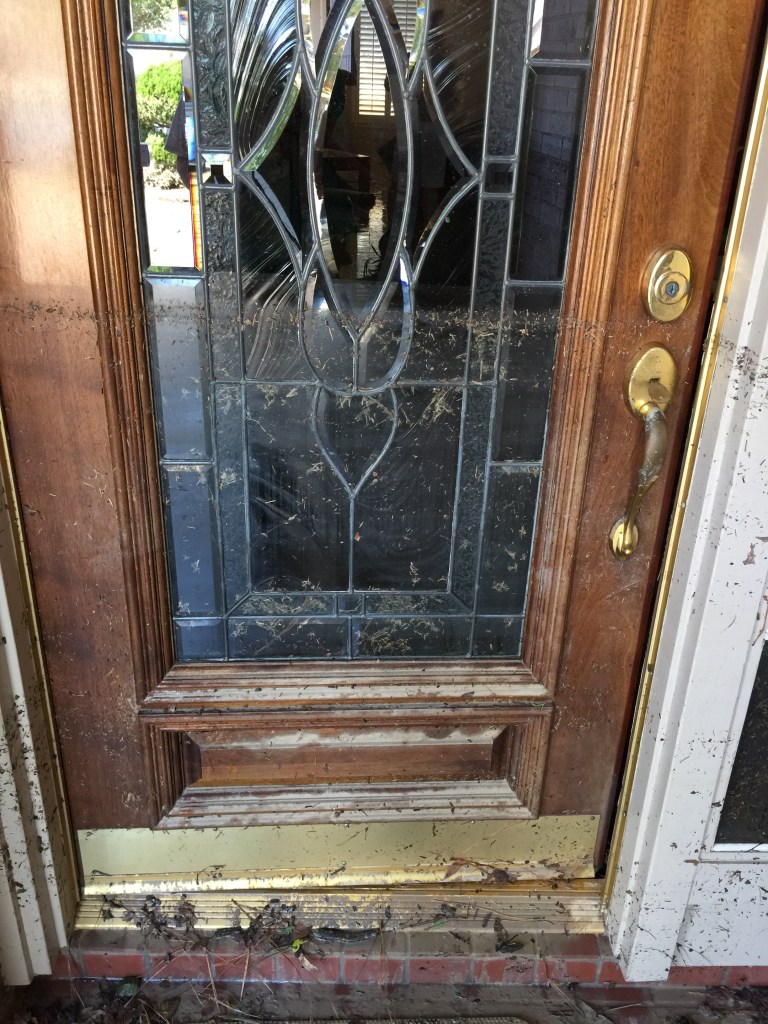
If you think the flood affected only people who built “too near the river,” think again. I live 1.7 miles from the river in a subdivision where 40 percent of the homes flooded. Many of my neighbors still live in hotels, with friends, or in campers as they try to restore their homes. Home damage in our little 350-acre neighborhood totaled an estimated $40 million. Most residents didn’t have flood insurance because they were nowhere near theflood plain. To finance repairs, many have taken on long-term debt, burned through retirement savings, or cashed in their children’s college funds.

Also, because of West Fork flooding during Harvey:

  • Union Pacific had to replace its bridge, disrupting rail traffic for weeks.
  • TxDoT had to replace part of the I-69 bridge, creating massive traffic delays during rush hours for months.
  • 44 percent of all Lake Houston Area Chamber businesses were adversely affected.
  • 100 percent of Humble businesses between Deerbrook Mall and the West Fork flooded on both sides of I-69.
  • 100 percent of Kingwood’s Town Center businesses closed for months.
  • Memorial-Hermann’s new Town Center facility flooded just before it opened and is still under repair.
  • Kingwood and Deerwood country clubs flooded and still have not fully reopened.
  • Lone Star College/Kingwood lost 11 of its 13 buildings for most of the school year.
  • Kingwood High School closed for 7 months and underwent repairs costing $60 million
  • 4000 students had to be bused to another high school an hour away for all that time
  • Humble ISD closed its Instructional Support Center, Welcome Center and Agricultural Barns for repairs.
  • Tax revenues from the Lake Houston area were impacted by 20-30 percent according to City of Houston estimates.
  • Humble ISD had to give out tax rebates for the last third of 2017.
  • Kingwood’s library closed for more than eight months.
  • River Grove Park had to be excavated from sand up to five feet deep.
  • Kingwood’s only community boat launch became landlocked.

Harvey knocked out the Union Pacific Railroad Bridge over the San Jacinto, disrupting rail service for weeks. Picture taken Sept. 14, 2017.

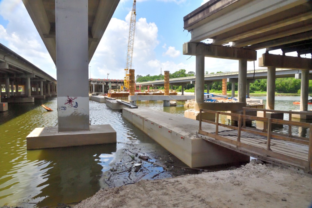
TxDoT hopes to complete I-69 bridge repairs in September, more than a year after Harvey. Picture taken May 13, 2018.

Causes for Concern

So, what caused all this devastation? Was it purely the magnitude of Harvey? Or are other factors at work?

Release Contributes to Flooding Far Outside 500-Year Flood Plain

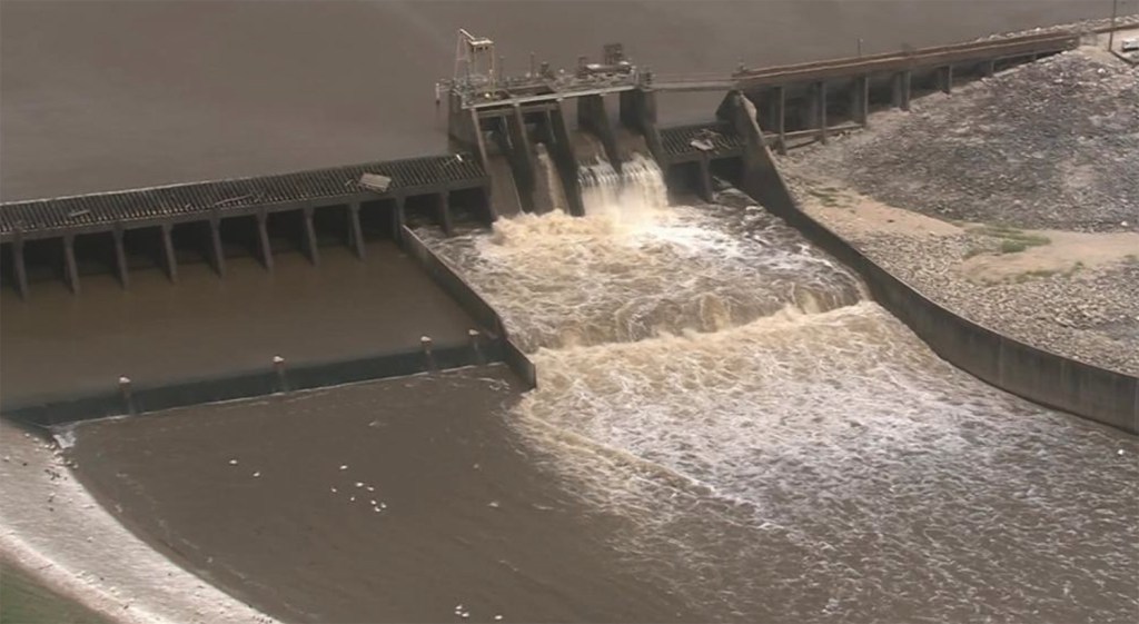
First, the release of 79,000 cubic feet of water per second from Lake Conroe at the peakof Harvey made the flood worse. That volume represented about ONE THIRD of all the water coming down the heavily populated West Fork between Humble and Kingwood where most of the damage took place.This extra water flooded people and businesses outside the 500-year flood plain.

New Sand Deposits Back Up River and Drainage Ditches

Second, Harvey swept sand downstream, in part, from approximately 20 square miles of sand mines between I-45 and I-69. This sand blocked and backed up the river at strategic choke points. It also blocked drainage ditches leading to the river.

This massive sand bar grew 1500 feet in length and 12 feet in height during Harvey. It now blocks a drainage ditch (left center) that empties the western third of Kingwood. More than 650 homes flooded in neighborhoods that connect to this ditch.

This sandbar deposited during Harvey is an estimated 8 feet in height and stretches nearly the entire width of the West Fork.

Until dredging removes such deposits, Kingwood and Humble residents live in fear of every approaching storm.

Greater than Expected Flooding on Minor Rains

Third, even minor storms are causing much greater-than-expected flooding because of such blockages.

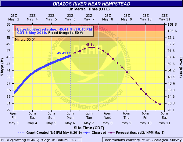
For example, a late-March storm this year dumped an average of five inches of rain across the watershed. It brought floodwaters two to three feet higher than a similar 5-inch rain at the beginning of last August – just before Harvey. Worse, the March flood happened AFTER Lake Houston had been lowered by 2 feet in anticipation of the storm.

Clearly, something has changed on the river. Because of massive sand deposits, such as those shown below, it won’t take another Harvey to cause significant damage.

During Harvey, thousands of homes and businesses flooded behind blockages, such as this one, where the West Fork enters Lake Houston.

At West Lake Houston Parkway (left), Harvey deposited sand in the tree tops. Sand now blocks water from flowing under the bridge and through the trees during a storm as it did before, narrowing the effective width of the river considerably.

The U.S. Army Corps of Engineers is organizing a dredging project to address such problems and expects to start in June. Until they finish and redraw the flood maps after dredging, no one really knows how many homes would flood due to Lake Conroe releases, such as those we have seen in the last three years.

Artificial Bottleneck

A fourth factor also worries Kingwood residents – the dam on Lake Houston has only two small floodgates. Combined, they have one-tenth the release rate of Lake Conroe’s. This creates a bottleneck. It greatly inhibits the ability of officials on both lakes to coordinate releases of water before storms as a flood mitigation strategy.

Houston Mayor Sylvester Turner has committed to adding ten more gates to Lake Houston and Congressman Ted Poe has asked the U.S. Army Corps of Engineers to fast-track the project.

But still, the gates must be built – just as the river must be dredged. Until we fix these problems, thousands of downstream residents will not be able to sleep soundly at night. For them, this is about survival, not recreation.

The Only Immediate Option to Reduce Flood Risk

Lowering the level of Lake Conroe is the only IMMEDIATE option that will provide a buffer against additional downstream flooding.

How much lowering is necessary? Is that extra foot really needed? If we got another storm as intense as Harvey, it would provide downstream residents only a two-hour buffer! That’s right. The storm would raise Lake Conroe that extra foot in just two-hours.

However, the two-foot reduction isn’t designed to protect against another Harvey. It’s designed to protect downstream residents against lesser floods that are abnormally high because of sand blockages like those shown above.

A two-foot reduction would let Lake Conroe absorb more water, decreasing the chances that SJRA would have to open flood gates. And if they had to open flood gates, it would delay the opening, giving downstream residents more time to evacuate.

The Lake Conroe Association will accept a one-foot reduction, but not two. That extra foot doesn’t seem like too much to ask, given all that’s riding on this decision for downstream residents as they still struggle to recover from billions of dollars in damages.

That buffer would also help protect the hundreds of Montgomery County homes that flooded around Lake Conroe and downstream from its dam.

Could another 500-year storm strike us this year? As unlikely as that seems, consider the fact that we’ve had three so-called “500-year storms” in the past three years. Something has changed out there affecting all of our assumptions. That’s why a little extra insurance would help.

Plea for Support

We ask our neighbors to the northwest for patience and support. Instead of lobbying against us, please join our fight. Help us expedite mitigation measures. With your support, our combined voices will bring change faster, so we can all return to normal life sooner.

Until then, we need to manage the river in a way that respects the lives and property of all residents on both sides of the dam, not just one.

Posted on 6/2/2018 by Bob Rehak

277 Days since Hurricane Harvey

Results of May SJRA Board Meeting and Decision to Temporarily Lower the Level of Lake Conroe

At its May Board meeting, the San Jacinto River Authority (SJRA) chose not to reconsider its April decision to lower the level of Lake Conroe temporarily at the peak of hurricane season. The board also chose not to put reconsideration of the resolution on its agenda for next month. This now puts the decision about whether to lower Lake Conroe temporarily into the hands of the City of Houston and the Texas Council on Environmental Quality (TCEQ).

Protest by Lake Conroe Association

The Lake Conroe Association protested last month’s board resolution to temporarily lower the level of Lake Conroe by up to two feet in September. The resolution was intended to help protect Lake Houston area residents from flooding until other mitigation measures, such as dredging, can be implemented. The Governor specifically directed the SJRA to make such protection part of its mission.

However, the president of the Lake Conroe Association (LCA), Mike Bleier, urged the board to reconsider its decision and was given unlimited time to present his case. Bleier spoke for more than half an hour. Bleier’s main concerns were the potential impacts on recreation, home values and businesses around Lake Conroe. Several other members of the association spoke in support of reconsideration.

Kingwood Residents Speak in Favor of Lowering

More than a dozen Kingwood residents also attended the meeting. Four spoke in favor of letting the motion stand.

Guy Sconzo, former superintendent of the Humble Independent School District, thanked the board for its decision to lower the lake. Then he talked about the impact of flooding on Lake Houston area infrastructure. His talk  addressed massive losses by the school district, Kingwood College, and more.

TxDoT hopes to repair damage to the I-69 bridge by September, more than a year after Harvey. In the meantime, residents endure massive traffic jams.

Robert Westover talked about a flooded retirement community where several elderly residents died due to injuries incurred during high-water rescues and related stress.

Amy Slaughter complemented the board for its decision to lower the lake and explained how it would help insure that people had time to rebuild while other flood mitigation measures were completed.

Dennis Albrecht, who owns homes on both Lake Houston and Lake Conroe also spoke. Albrecht compared the relative impacts of flooding and lower lake levels on home values. Albrecht pointed out that the value of his Lake Conroe home has increased steadily despite lower lake levels at times. He also pointed out the devastating impact of the flood on the value of his Lake Houston home. “There’s no comparison,” said Albrecht.

Many other Kingwood residents attended the meeting to support the SJRA Board’s decision.

When is a lowering not really a lowering?

Bleier said that his members would accept a one foot lowering, but not two. Several Kingwood residents pointed out that evaporation already typically reduces the level of the lake by more than a foot and a half during September. The LCA’s decision to accept a one-foot lowering was, therefore, actually no concession at all; they would likely give up nothing.

Assuming average loss due to evaporation, the actual lowering would amount to only 4.8 inches.

Dianne Lansden, co-chair of the Lake Houston Area Grass Roots flood prevention initiative, and I gave Bleier a tour of the devastation in Humble and Kingwood yesterday. After a two-hour tour, while professing to be sensitive to the needs of downstream residents, Bleier proceeded to tell us the concerns of upstream residents. Among them: his members might not be able to take their boats to lakefront restaurants. (Editorial comment: Spooky shades of Marie-Antoinette!)

Not All Lake Conroe Residents Support LCA

To be sure, not all Lake Conroe residents agree with Bleier. Hundreds of homes on Lake Conroe also flooded during Harvey and reportedly most of the owners also favor a temporary seasonal lowering of the lake level, according to SJRA Board Chairman Lloyd Tisdale.

Lake Lowering Could Still be Nixed

Despite the SJRA board’s decision this morning, Lake Conroe still may not be lowered. To take effect, both the City of Houston and the TCEQ must also agree to lower the lake. The City owns two thirds of the water in the lake. The TCEQ must decide whether any lowering will count as an emergency release or be deducted from the City’s draw rights. If not considered an emergency release, the City may not support the decision to lower the lake.

Uncertainty Surrounding Weather Outlook

Some forecasters are beginning to worry about a possible drought. As of May 22, Drought.gov pointed out that abnormal dryness is currently affecting approximately 13,612,000 people in Texas, which is about 54% of the state’s population.

However, NOAA issued an outlook saying that 2018 will be a slightly above average hurricane season.

And, Thursday night, the National Hurricane Center predicted a 90% chance of tropical development in the Gulf this weekend.  That system could dump up to ten inches of rain on neighboring Louisiana and other gulf states.

How a 10-Inch Rain Could Affect Kingwood

If we got ten inches of rain from a storm, such as the one entering the Gulf this weekend, that could constitute a 50-year rain at a time when the river is clogged with sand. That could produce a higher-than-normal flood for that amount of rainfall, and re-flood parts of Kingwood and Humble before dredging could even begin.

Personal Recommendation

Personally, I favor lowering the level of the lake. The actual amount of manual lowering, assuming this is an average year, would be only 4.8 inches. Even in the depths of the 2011 drought, the loss of 4.8 inches would have not have been disastrous.

There’s little chance, despite the hyperbolic rhetoric from LCA that 4.8 inches will destroy the Lake Conroe area. And it could help protect the Lake Houston area from another disaster.

In fact, in eight of the last 18 years, Lake Conroe has lost more than two feet of water due to evaporation and the lake is still one of the state’s most desirable destinations for tourists.

LCA Vows to Escalate the Fight

LCA has vowed to press its fight with the City and TCEQ and claims to have enough political support lined up to kill the proposal to lower Lake Conroe temporarily.

So get involved. Urge the TCEQ, Mayor and City Council to TEMPORARILY lower Lake Conroe  until other mitigation measures, such as dredging, take effect.

Posted on 5/25/18 by Bob Rehak

269 Days since Hurricane Harvey