At one of the first large public meetings since Covid began, several hundred people crowded into the Kingwood Community Center last night. They came to see the City unveil floodgate and dredging plans for Lake Houston. Stephen Costello, PE, the City’s Chief Recovery Officer, addressed dredging. And Chris Mueller, PhD, PE, of engineering firm Black & Veatch discussed adding more floodgates to the Lake Houston Dam. Mayor Pro Tem Dave Martin coordinated the meeting.
In late 2019, the Army Corps finished hydraulic dredging in the area south of the West Fork mouth bar. Then in early 2020, the City of Houston began mechanical dredging to extend the effort. In terms of the estimated dollars designated for dredging, the effort is about halfway done.
The first four rows on this chart are done or almost done. They total $114 million out of a projected total of $222 million.
Scope of Long-Range Dredging Plan Still in Development
A long-range dredging plan for Lake Houston is critical. We must understand where the sediment comes from, how fast it builds up, where it builds up, and the consequences of not removing it periodically.
The numbered dots in the photo above show channels south of the East and West Forks draining into Lake Houston where sediment can also build up.
Costello says the City is currently working with affected homeowner associations to discuss cost-sharing arrangements.
He also says that the City must identify a long-range site for depositing the spoils that is suitable for hydraulic dredging. He called the mechanical dredging now in progress “not sustainable.” Currently, the City is using Berry Madden’s property on the West Fork south of Kingwood’s River Grove Park to deposit the mechanical dredging spoils. That’s a long haul for barges on the East Fork.
Next Dredging Steps: Channel to East Fork and East Fork Itself
Contractors must next deepen the channel between the West and East Forks of the San Jacinto to move dredging equipment and spoils back and forth (see below).
Current location of dredging is near yellow dot.
From there, dredgers will move slightly north of where Luce Bayou (far right) enters the East Fork and begin dredging the East Fork mouth bar. See large circle above. The map shows that area grew shallower by up to nine feet between 2011 and 2018. Imelda, in September 2019, made it grow even shallower. Note the fresh deposits of sand in the photo below now poking up above the water.
Growth of East Fork Mouth Bar after Imelda in September 2019. Photo taken in November 2019.
Additional Floodgates for Lake Houston Dam
Chris Mueller of Black & Veatch then discussed the reasons for adding additional floodgates to Lake Houston, preliminary engineering findings, and an implementation schedule.
The primary objective: to increase the outflow capacity of the dam to reduce the risk of future flooding. However, he emphasized that reducing the risk for people upstream of the dam cannot have an adverse impact on people below it. See below.
He emphasized that Lake Houston is, first and foremost, a drinking water reservoir. He also emphasized that the dam is almost seventy years old and near the end of its useful life. Significant safety issues exist in working with such old concrete.
Calculating the Benefit/Cost Ratio of Additional Floodgates
Mueller then explained how FEMA calculates the benefit/cost ratio of additional floodgates.
On the benefit side, it considers: the reduction in water surface level; how many buildings and streets that will prevent from flooding; reduced societal impacts; and reduced impacts to business revenues. These are primarily damage costs avoided.
On the cost side of the equation, FEMA factors in construction costs and annual operation and maintenance costs.
To win project approval, the City must show that the benefits of additional floodgates exceed the costs in a 100-year storm, similar to Imelda. Such a storm elevates the lake 10 feet.
The peak inflow to Lake Houston in a 100-year storm: 286,000 cubic feet per second (CFS), enough to fill the Astrodome in 3 minutes! However, during Harvey, SJRA estimated the peak inflow at 400,000 cfs.
Proposed Alternative Produces 11-Inch Benefit Nearest Dam
A hydrologic and hydraulic analysis conducted by Black & Veatch will help prove up the benefit/cost analysis. The San Jacinto Watershed (including Buffalo Bayou) includes flow from eight counties.
In evaluating about ten alternatives for adding floodgates, Black & Veatch considered both cost and non-cost factors listed below.
The company’s first choice was to install additional gates on the earthen portion of the dam on the east side. But environmental considerations there would have delayed the project by a decade or more.
So they decided to recommend a 1,000 feet of crest gates on the west side of the spillway instead. See example of crest gates in operation below.
An air bladder near a bottom hinge raises or lowers the floodgatesto let water in/out
Such gates would increase the discharge capacity to 45,000 cfs, more than four times the current capacity of 10,000 cfs. That’s still only about a third of the discharge capacity of the floodgates on Lake Conroe. But according to Martin, that would still be enough to lower the level of the lake 4 feet in 24 hours.
However, before floodgate construction can begin, engineers must evaluate:
Downstream impacts and how to mitigate them
Impact to the stability of the existing concrete dam
Back in the 1950s when the Lake Houston dam was built, engineers did not use rebar. So this will be a delicate operation. Contractors must cut 6 feet into the existing spillway; cap the remaining concrete with a slab; and install the crest gates on top of the slab.
Black & Veatch must also develop an operations protocol for new floodgates that maximizes upstream benefits and limits downstream impacts. Mueller shared this schedule with attendees.
Best-Case Project Timeline Shows Completion in 2024
Schedule as of 7/8/2021.Detailed engineering could take another year.
A best-case scenario shows construction starting at the end of 2022 and finishing before the start of hurricane season in 2024. So, at least three more hurricane seasons to get through before seeing any benefit from additional gates.
In its March 10th board meeting, the Coastal Water Authority (CWA) accepted the recommendation of a preliminary engineering report to add one thousand feet of crest gates to the uncontrolled spillway portion the Lake Houston Dam. The additional release capacity would let operators shed water faster before, during or after major storms to reduce the risk of flooding.
At the March meeting, directors also approved $4.4 million to begin Phase II of the project. Phase II calls for Black & Veatch to proceed to final engineering of the gates and a coffer dam to protect the work area during construction.
This morning, at its May board meeting, directors received an update on the progress of Phase II work to date and plans for the remainder of the project.
Start of Phase II Engineering Approved in March
In the March meeting, CWA approved funds to begin Phase 2 of the engineering which includes the final design of the selected alternative by Black & Veatch. The selected alternative was “crest gates” constructed on the uncontrolled spillway portion of the dam on its west side. (See below.)
Looking NE at the Spillway of the Lake Houston Dam is in foreground. One thousand feet (about a third) of this spillway will be replaced with crest gates. Gates will be placed at the end closest to the camera position in the image above.
Dam operators can raise or lower crest gates from a bottom hinge, much like the lid on a piano. When in the up position, gates hold water back. When lowered, they release water.
Also in March, CWA and Black & Veatch completed negotiation of the scope and fee for the final design. The key deliverables during Phase II will include:
Plans to modify the spillway to support the 1,000 linear feet of crest gates (in five 200-foot long sections)
Design of the cofferdam system to protect the work areas during construction
Preparation of a new gate operations plan for CWA Lake Houston Dam operators.
Director Douglas Walker moved to authorize the Executive Director to issue a contract amendment with Black & Veatch Inc. in the amount of $4,465,727.00 for “Phase 2 – Final Design of the Lake Houston Dam Spillway Improvement Project.” Director Giti Zarinkelk seconded the motion. The Motion carried unanimously.
May Update
In the May board meeting this morning, directors received an update on Phase II work to date and plans.
In April, the design team held a number of workshops and coordination meetings.
Black & Veatch also completed three weeks of field surveying of the existing spillway; that’s why CWA temporarily lowered Lake Houston during that period.
In other news, for next steps CWA will:
Submit the permit application to the US Army Corps of Engineers by the end of May.
Support City of Houston in a public outreach meeting scheduled for June 17. The public outreach meeting will coincide with the public comment period for the permit application. CWA expects permitting to take nine months, i.e., through March of 2022.
Complete final design by the end of September 2022.
Screen capture from portion of CWA Board meeting today shows status of Phase II Design work on the dam.
Next Steps
Does all this mean construction is assured? No. The Army Corps could reject the permit or FEMA could find some fault with the plans. But at least it shows progress. If all plans and permits are approved, construction dollars have already been committed by FEMA. Originally, construction was supposed to have been completed within three years from April 8, 2020. That now looks unlikely unless the City can obtain a deadline extension from FEMA..
Posted by Bob Rehak on 5/12/2021
1352 Days after Hurricane Harvey
https://i0.wp.com/reduceflooding.com/wp-content/uploads/2021/05/20210512-Screen-Shot-2021-05-12-at-10.23.26-AM.jpg?fit=1200%2C670&ssl=16701200adminadmin2021-05-12 12:28:352021-05-12 15:19:42May 2021 Gate Project Update for Lake Houston Dam
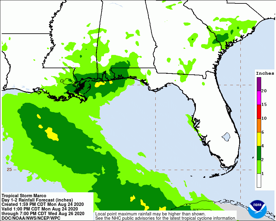
Many anxious flood victims worry openly on social media about about the possibility of flooding by back-to-back tropical events. Should we lower Lake Conroe? Is it too late? Will we flood again? Why aren’t they releasing water?
The novelty of having two tropical storms in the Gulf simultaneously has added a high degree of uncertainty to weather forecasting at the moment. The forecast tracks, intensities and dangers of Marco and Laura seem to change every few hours.
This is precisely why we need more and bigger flood gates on Lake Houston.
By the time we are certain what will happen with these storms, it will likely be too late to release water if we need to.
The bewildering multitude of competing weather forecast models complicates matters. They show landfall anywhere from Corpus Christi to the Mississippi just two days before the storms’ arrival. It reminds me of a fortune cookie I once got. It said, “A man with two clocks never knows what time it is.”
The National Hurricane Center shows only a slight chance of flash flooding for the areas hit directly by Marco and those are far east of us. Rainfall potential from Marco through Wednesday evening for the Houston Area is less than an inch, according to the latest NHC predictions.
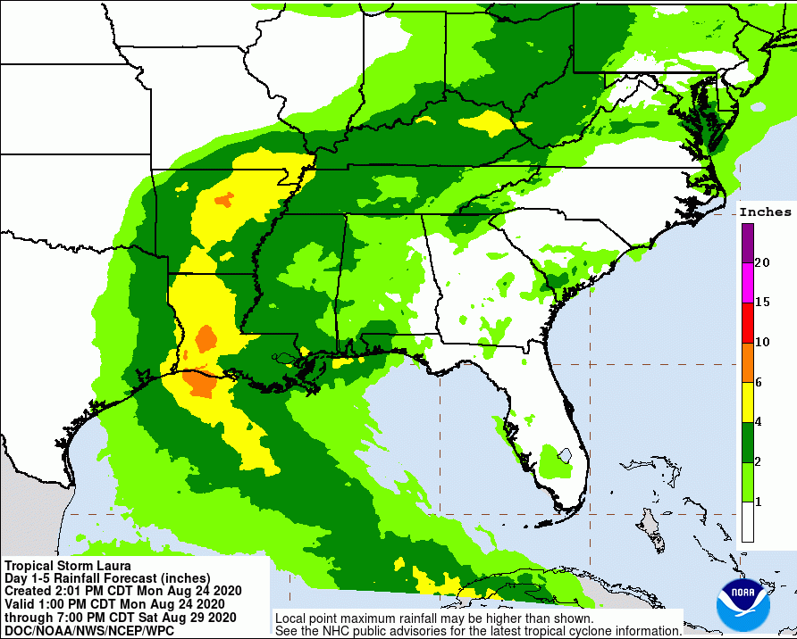
Even though Laura’s cone of uncertainty has shifted slightly east today, the Houston Area remains on the western edge of the cone.
At the moment, NHC predicts Laura will bring Houston 2-4 inches of rain, and the Lake Conroe area less than 2.
That’s enough to raise the chance of flash flooding to 5-10%.
Laura’s maximum sustained winds are near 60 mph with higher gusts. NHC predicts little change in Laura’s strength today, but predicts the storm will strengthen when it moves into the Gulf of Mexico. They foreast Laura will become a hurricane on Tuesday, with additional strengthening on Wednesday. Tropical-storm-force winds currently extend outward up to 175 miles, primarily to the northeast and east of the center. As Laura approaches the Gulf Coast, swells will cause life-threatening surf and rip-current conditions.
Tropical storm force winds should reach the Texas coast between 8 a.m. and p.m. on Wednesday. Most of the Houston Area will have a 40-50% chance of experiencing winds greater than 39 mph.
Alert Houston has just issued the following notice:
“The National Weather Service has issued a Tropical Storm Watch for Houston. Coastal portions of the city are also under a Storm Surge Watch. Although the exact track and intensity of Laura is still unknown, Houston residents should pay close attention and begin taking steps in the event an emergency situation develops.”
Jeff Lindner, Harris County Meteorologist, put a finer point on it. “Tropical storm force winds are likely along and east of I-45 with sustained winds of 35-45mph across portions of Galveston, Harris, Montgomery and Walker Counties. Strong winds of 45-55mph will be possible across Chambers, Liberty, San Jacinto, Polk, and Trinity Counties. It is possible that near hurricane conditions could scrape close to eastern Chambers and eastern Liberty counties.”
The answer is obvious. You enlarge the discharge capacity of Lake Houston by adding more and bigger gates to the spillway.
Gates on Lake Houston have one-fifteenth the discharge capacity of those on Lake Conroe.
Lake Conroe can release water 15 times faster than Lake Houston. 150,000 cubic feet per second vs. 10,000. With that in mind, the likelihood, at this hour (5pm Monday), is that water released from Lake Conroe could not get into the Gulf before Wednesday when the storms arrive.
And that, in a sentence, is why we need more and bigger flood gates on the Lake Houston Dam. Remember Marco and Laura, and that knot in the pit of your stomach, the next time the subject of gates comes up.
By the way, neither Lake Conroe, nor Lake Houston, is releasing water at this time. Lake Conroe is at 199.76 feet above sea level and Lake Houston is at 41.6 feet. Both are already below their normal levels, though not as low as many would prefer. At 4:24 this afternoon, the SJRA issued a press release saying that, “We continue to watch Laura closely. Right now the projected totals of rainfall in the Lake Conroe watershed are very low.”
Posted by Bob Rehak on 8/24/2020 at 5 pm
1091 Days after Hurricane Harvey
https://i0.wp.com/reduceflooding.com/wp-content/uploads/2019/02/Screen-Shot-2019-02-04-at-10.12.58-PM-copy.jpg?fit=1500%2C822&ssl=18221500adminadmin2020-08-24 16:42:522020-08-24 17:36:06Remember Uncertainty With Marco, Laura; It’s Why We Need More, Bigger Gates on Lake Houston
On January 10, Mayor Sylvester Turner wrote the SJRA Board to support continued lowering of Lake Conroe. “This temporary measure,” said the Mayor, “will help mitigate against future flooding until permanent flood gates can be installed and dredging of the San Jacinto’s West Fork can be completed.”
Reminding LCA Who Owns the Water
The Mayor also reminded the Lake Conroe Association (LCA) that the City of Houston owns two thirds of the water in Lake Conroe.
Changing the LCA Narrative
Turner also addressed an LCA narrative that claims Lake Conroe was not built for flood control. It was built for drinking water, they say. But the letter changes that narrative. It says, “While the lake was originally constructed as a reservoir for drinking water, the Houston region has become increasingly prone to flooding due to population growth, development and more frequent storms with record rainfall. Both the City of Houston and the State of Texas recognize that flood control must be a consideration. The proactive release water is an effective measure until more permanent solutions can be completed.” See the full text of the Mayor’s letter below.
I have not always agreed with Mayor Turner, but I support him wholeheartedly on this.
Clash of Political Titans
Tuesday, Montgomery County Commissioners will vote on a resolution recommending to END the seasonal lowering of Lake Conroe.
I suspect Harris County Commissioners and the governor may enter this fray before the final vote.
Posted by Bob Rehak on 1/14/2019
868 Days after Hurricane Harvey
https://i0.wp.com/reduceflooding.com/wp-content/uploads/2020/01/1.10.2020-Lake-Conroe-Water-Level-NA.doc.jpg?fit=1700%2C2200&ssl=122001700adminadmin2020-01-13 23:31:352020-01-17 08:54:29Houston Mayor Sylvester Turner Supports Continuing to Lower Lake Conroe Seasonally to Help Mitigate Flooding
With 2019 almost behind us, we should look back to see what we accomplished on flood mitigation. Tomorrow, I’ll take a look at the stories that will likely define 2020.
Limited Dredging
In 2018, FEMA and the Army Corps announced that they would dredge 2.1 miles of the San Jacinto West Fork when they were given authority to dredge 8 miles. Questions immediately started to swirl about why they were not dredging all the way to Lake Houston. The answer was “part of the mouth bar was there before Harvey and we can only spend disaster relief funds on what Harvey deposited.”
The mouth bar as it existed shortly after Hurricane Harvey. Photo taken 9/14/2017.
Regardless, they left the biggest blockage in the river. Imelda washed a tremendous amount of sediment downriver. In mid-October, RD Kissling sent me a photo from his kayak. He as standing in water less than knee deep 700 yards south of the mouth bar. It’s important to understand that sand bars are like ice bergs. You only see the tip above water. Most of the bar exists below water. And much of this mouth bar remains to be removed.
To learn more about this controversy, search this site using the key words “mouth bar.”
Flood Mitigation Legislation: A Big Win
No one budgets for disasters, such as Hurricane Harvey. So after the disaster, cities and counties had to scramble for grant money to even qualify for matching funds from the Federal government. More than two and a half years after the event, money is finally starting to trickle down to the areas that need it to implement flood mitigation projects. That’s thanks in large part to Senator Brandon Creighton who authored Senate Bill 7.
SB7 creates dedicated Texas Infrastructure and Texas Infrastructure Resiliency Funds for flood control planning and the funding of flood planning, mitigation, and infrastructure projects. The Texas Water Development Board is finalizing rules for the distribution of those funds right now. SB500, a supplemental appropriations bill, includes funding for SB7 and an amendment that would dedicate $30 million for dredging at the confluence of the San Jacinto and Lake Houston. State Representative Dan Huberty authored the amendment to SB500 that provides the $30 million.
For more information about legislation affecting this area, see the Legislation page of this web site or search using the key words “SB7” or “SB500.”
Sand Mining Legislation: One Small Gain, Some Big Losses
Activists statewide pushed for legislation to reign in the excesses of an out-of-control aggregate industry. Here in the Houston area, State Representative Dan Huberty introduced HB 907. It passed and doubles the penalties for not registering a sand mining operation. It also increases the frequency of inspection from every three years to two years and established a registry of active sand mines.
Picture of the West Fork of the San Jacinto the day it turned white (11/4/2019). The TCEQ later issued a notice of enforcement to the Liberty Materials mine upstream for dumping 56 million gallons of white goopy pollution into the West Fork.Water samples indicated 25 times the normal amount of suspended solids.
That was the only bill that the high powered lobbyists of TACA (the Texas Aggregate and Concrete Association) would allow to pass. That’s mostly because their members are already registered.
However, other important bills died in committee due to the lobbying power of TACA.
HB 908 would have provided for penalties up to $50,000 for water code violations and every-other-year inspections.
HB 909 would have created best management practices for sand mines.
HB 1671 would have extended water quality protections to the West Fork of the San Jacinto currently enjoyed by the John Graves District on the Brazos and attached penalties for non-compliance with best practices defined under HB909.
HB 2871. Would require sand mines and other aggregate production operations to acquire a reclamation permit and to file a performance bond ensuring reclamation.
For more information about sand mining in the Lake Houston area, see the Sand Mining page of this web site. You can also search on the key words “sand mining, TACA, Triple PG, TCEQ, breach, Liberty, and white water.”
Artist’s conceptual drawing of a high-rise development called The Herons: Kingwood.
The tallest buildings would have been 500 feet and located on the edge of the current floodway. That floodway will almost certainly expand in light of new Atlas-14 rainfall data. The developers also announced a marina that would have held 640 40-foot boats and 200 jet skis. There were no evacuation routes that would have remained above water in the event of a flood.
The developer’s web site now says the project is on hold, pending improvements to the West Fork and Lake Houston.
For more information on this development, see the High Rises page of this web site or search for the key words “Romerica, high rises, eagle, or The Herons.”
The $2.5 Billion Flood Bond Equity Flap
When the wording for Harris County’s historic $2.5 billion flood bond offering was worked out in early 2018, leaders from the Humble/Kingwood area in Precinct 4 argued to include the notion of an equitable distribution of funds. Why? Historically the Flood Control District had focused more on projects in other parts of the county, especially Precinct 1, that Precinct 4.
In one meeting after another, Ellis’ ringers showed up in commissioners court to complain about discrimination in the distribution of funds for buyouts, construction spending, and more. Yet in every category, Ellis’ precinct already had the lion’s share of funding.
This is an on-going controversy that affects everyone in the Lake Houston area. Ellis is looting transportation dollars from Precinct 4. You have to hand it to Ellis. Even if he doesn’t know what equity means, he knows how to work the system.
For more information on this topic, search this site using the key words “equity or Ellis.”
Meanwhile, the Supreme Court of Texas ruled that the language in the summary of the referendum on the ballot was misleading. It failed to disclose that the money would be raised through a new tax. So the Court ordered a revote.
In 2018, the Mayor “resold” the fee by saying, “If you want a lockbox around the money, vote FOR Proposition A. If you don’t want a lockbox around the money, vote AGAINST it.”
It was another artful dodge. There was nothing in the language of the bill to create a lockbox. The language in Prop A was almost identical to the original bill. But the funding formula was even looser!
Unaware voters once again approved the fee. And the Mayor continued to divert money from the fund. These diversions became a central element in the Mayoral campaign this year after thousands of people flooded in May and again during Imelda.
Nevertheless, the Mayor won re-election.
To learn more about this topic, search this site using the key word “Proposition A.”
10 New Gates for Lake Houston
The flood gates on Lake Conroe can release water 15 times faster than the gates on Lake Houston. During Harvey, that bottleneck contributed to the flooding of thousands of homes. A study showed that additional gates would have lowered the water level by almost two feet in the event of another Harvey. During smaller storms, the gates would also help pre-release water faster to create a buffer against possible flooding.
Lake Houston can shed water at 10,000 cubic feet per second. Lake Conroe can shed it at 150,000 cubic feet per second.
The City of Houston applied for a grant from FEMA and the Texas Division of Emergency Management to add ten new gates. FEMA approved the project. It’s happening in two phases. The first includes design and an environmental survey. The second includes construction. Each will take 18 months. We’re now six months into Phase One.
Details of dam improvement project.
For more information on this topic, search this site using the key word “gates.”
Temporary Seasonal Lowering of Lake Conroe
After Harvey, people in the Lake Houston area started pleading for more upstream detention, dredging and gates. Dredging started immediately. The project to add more gates to the Lake Houston spillway has also started. Upstream detention is still years way. The San Jacinto Watershed Study is only now beginning to identify possible locations.
Many lakefront property owners on Lake Conroe, however, claim the lowering hurts their property values and damages their bulkheads. Buses full of protesters showed up at the December SJRA Board meeting wearing red shirts that say, “Stop the Drop.” So many came that two busloads full of people had to be turned away.
Angry Lake Conroe residents showed up at the last SJRA board meeting in busloads.
Net: the policy to lower Lake Conroe temporarily is under assault. The SJRA will likely vote on whether to continue the policy in February. The SJRA will hold two additional meetings at the Lonestar Convention and Conference Center in January and February to give everyone who wants to provide input a chance to do so.
For more information on this topic, search this site using the key words “lake lowering.”
This is another issue that will carry over into 2020.
For more information on this topic, search this site using the keywords “Perry Homes, Woodridge Village, Figure Four Development, PSWA, Elm Grove, Spurlock, cease and desist, detention, what went wrong, North Kingwood Forest, or drainage criteria.”
There’s your digest of the biggest stories of 2019. 2020 to follow.
Posted by Bob Rehak on December 19, 2019
842 Days after Hurricane Harvey and 92 since Imelda
The thoughts expressed in this post represent opinions on matters of public concern and safety. They are protected by the First Amendment of the US Constitution and the Anti-SLAPP Statute of the Great State of Texas.
https://i0.wp.com/reduceflooding.com/wp-content/uploads/2019/12/Slide11.jpeg?fit=1200%2C900&ssl=19001200adminadmin2019-12-19 11:45:402019-12-19 12:01:13The Biggest Stories of 2019
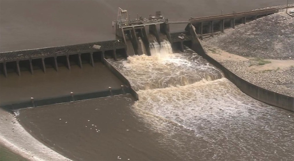
Before Harvey hit, we knew tremendous rains were coming. But we could do little to prepare Lake Houston for the onslaught. The small gates you see in the photo below release a combined 10,000 cubic feet per second (CFS). That’s nothing compared to the 150,000 from the gates at the Lake Conroe Dam.
Lake Houston’s gates release a maximum of 10,000 CFS.The gates at Lake Conroe can release water at up too 150,000 CFS...15X faster.
We Were Sunk
When Lake Conroe had to open its gates during Harvey, we were sunk. Literally. Had we had bigger, more modern gates on Lake Houston, we might have been able to lower the lake fast enough to avoid flooding thousands of homes.
11-Foot High Wall of Water Cascaded Over Spillway
Of course, Lake Houston also has a spillway. In fact, the spillway represents the primary way to shed water from the lake. The top of that spillway is at 42.38 feet.
Interestingly, the WAY more gates would prevent flooding was not through pre-release; Harvey would have refilled the lake in a matter of hours and the storm lasted days. Rather, additional gates would have widened the spillway area so more water could move over the dam every second. Think of it in these terms: twice the width, half the height. (That’s an over-simplified example of how the principle works; ten more gates would not actually double the width.)
Is Pre-Release Practical?
The Frees & Nichols study only considered one case – Harvey. For lesser floods, the gates could help make pre-release a viable strategy for the Lake Houston Area. At least in my opinion.
Here’s how.
More gate capacity could help offset the volume of water released from Lake Conroe, to reduce the risk of Conroe flooding Houston again.
More gate capacity could release more water in less time, thus reducing uncertainty when pre-releasing before a storm. That would allow officials to delay releasing water until they were sure they needed to. And that could save precious water in the event that a storm veers off in another direction at the last minute. We may know that a storm will cross the area. But it’s much harder to tell where the heaviest rainfall will occur. For instance, during Imelda, parts of the East Fork received more than 20 inches of rain while Lake Conroe received only two.
In the last year, the City prevented homes from flooding several times by pre-lowering the lake. But the small gate capacity meant that we had to start releasing water DAYS beforehand to make an appreciable difference in the lake level. That has to be nerve wracking for Public Works.
Where the Gate Project Stands
Earlier this year, the City of Houston secured a FEMA grant to design and construct more gates for the Lake Houston Dam. The two-phase grant covers design and construction. Each phase must be completed within 18 months, though extensions are possible. Currently, we are four months into the 18-month design phase. That means we should see more gates by mid-2022.
In the meantime, the photos below give you a feeling for the immensity of the project.
The height of the trees on the San Jacinto River below the dam gives you a feeling for the height of the dam.Looking SE.Repairs are underway to the structures below the Lake Houston dam.Note the trees caught on top of it.Looking west over the Lake Houston Damwhich dates back to 1953.
Posted by Bob Rehak on 11/14/2019
807 Days since Hurricane Harvey
https://i0.wp.com/reduceflooding.com/wp-content/uploads/2019/11/RJR_3872.jpg?fit=1500%2C1000&ssl=110001500adminadmin2019-11-13 18:38:402020-01-17 10:13:11Aerial Photos of Lake Houston Dam Dramatize Need for More Gates
High-rise development in the floodplain has pushed Lake Houston Area flood mitigation projects out of the headlines lately. So here’s an update on where things stand from Stephen Costello, the City of Houston’s chief resiliency officer and Mayor Turner’s flood czar.
Extending Dredging to Include Mouth Bar
It’s becoming increasing unlikely that we’ll be able to piggyback on the current dredging project. The City and Federal Government are still arguing about how much of the mouth bar existed before Harvey.
The mouth bar almost totally blocks the West Fork where it meets Lake Houston. FEMA and the City of Houston have argued for almost a year over how much existed before Harvey.
Regular readers may remember that FEMA and the Corps stonewalled action on the mouth bar because of the Stafford Act. The Stafford act is the enabling legislation for FEMA. It bars using disaster relief funds to address pre-disaster issues such as deferred maintenance.
The two sides argued for almost a year about how much of the bar existed before Harvey and how much resulted from Harvey. They have finally agreed on a procedure to answer that question. It’s called the Stockton Protocol and was developed at Stockton University in New Jersey to answer similar questions after Superstorm Sandy.
The protocol involves analysis of core samples from the mouth bar. According to Costello, the City hired a geomorphologist to harvest the core samples last week. It should take two to three weeks to analyze the layers in them.
Mouth Bar Disposal Issues Drag Out, Too
Another issue regarding the mouth bar has to do with disposal of the dredged materials. The City and the Corps have tried to agree on and permit a site since October 11 of last year. Three issues come into play when evaluating such sites: volume, cost and environmental considerations.
Next phases of dredging (proposed)
The site must be large enough to accommodate the volume of dredged materials.
The site must also be close to help hold down costs. The farther the site, the higher the costs. The amount of booster pumps, diesel fuel, pipeline, and manpower needed all increase with distance.
Re: environmental considerations, the Corps would prefer a below-ground site such as an old sand pit. That reduces the chance that sand and silt will end up back in the river during the next flood. It also eliminates the issue of possibly reducing the volume of the floodplain. On the other hand, above ground sites are easier to find and one exists that is much closer than any abandoned mine.
At the moment, managers are trying to find the optimal solution given all three variables.
Of course, the volume issue will depend on how much FEMA agrees to remove – after analysis of core samples and after the federal government resumes business.
Rapidly Shrinking Window to Save $18 Million
Before this process started dragging out, taxpayers had a chance to save $18 million. That represents the cost of mobilization and demobilization of the current dredging program on the West Fork. Piggybacking the mouth bar project on top of the current project would eliminate that cost for Phase II because the people and equipment would already be on site and could just continue working.
The current project should end in late April or early May. Costello says the City is already starting to look at contingency plans in case the shutdown drags on or permitting the disposal site becomes problematic.
Contingency Plans Considered
DRC, the company engaged to clean up debris in the lake, also does dredging. DRC has already bid the job and agreed to work for the same price as the current dredgers.
The leading permittee for the disposal site has agreed to store the dredges on his property if necessary until Phase II kicks off.
Current Barriers to Reaching An Agreement
But in the meantime, huge questions remain about volume and cost. With core samplings not yet analyzed, it’s hard to determine how much material will have to be removed from the river. So it’s also hard to determine whether the available money will stretch far enough to remove everything FEMA approves. At this point, the City has committed $15 million and the State $50 million. FEMA remains the big question mark.
Next steps:
Analyze core samples and agree on volume to be removed
Agree on disposal site and permit it
Determine available funds
Develop a dredging plan optimized for all variables above
Execute the plan
Status of New Gates for Lake Houston Dam
New gates for the Lake Houston dam also remain in limbo. Costello met with FEMA in December and again in early January. FEMA questions the benefit/cost analysis presented by the City. The City originally estimated a 2.8 b/c ratio for the project. That put it high on everyone’s priority lists. However, that may come down. Costello still believes the ratio will come in above 1.0, the cutoff (because benefits still exceed costs). A consultant is currently reconfiguring the estimate.
Lake Houston Dam is primarily a spillway. Small floodgates can lower lake if given enough time. But that requires starting before weather predictions acquire a high degree of certainty, thus raising the risk of wasting water if the forecast changes.
Concern about Potential for Downstream Impact
FEMA also wants assurances that new gates will not negatively impact downstream residents. The City remains confident that downstream residents will not experience impacts. The purpose of the gates is to be able to pre-release water at a controlled rate before storms hit to minimize the volume going over the spillway. Also, the county is reportedly offering buyouts to vulnerable homeowners below the dam.
If the City cannot convince FEMA that the threat to downstream residents will not increase, the City will have to look for an alternative source of funding, such as adding a penny to water bills.
Next Steps on Additional Gates
Assuming Costello can convince FEMA that there will be no negative impact downstream, the next steps would be:
Final design
Permitting
Construction
Each phase could take six months to two years, depending on unforeseen obstacles, such as political headwinds and completion of the long-awaited San Jacinto River Basin Watershed Survey.
San Jacinto Watershed Survey Status
In March of last year, the SJRA proposed a new survey of the entire San Jacinto Watershed. Projects such as maintenance dredging, additional gates, and additional upstream detention, all depend on the outcome of this study.
To properly design gates, for instance, engineers need to know the volume of water they need to shed in a given period of time.
To properly design maintenance dredging, they also need to know how fast the river is and lake are silting up.
The estimated cost of this study was about $2 million. Consultants have been ready and waiting since last April for the green light. Unfortunately, FEMA went back and forth with the SJRA and its partners on this project for eight months. According to Costello, FEMA was ready to write the check in December when the Federal Government shut down.
Next Steps:
Deposit FEMA check
Execute study
Final report
Expect this one to take 18 months from the start date.
Need to Mitigate Mitigation Funding
The saga of this study epitomizes the need to improve disaster mitigation procedures. Flooding along the Gulf Coast is foreseeable. If we budgeted for it, we wouldn’t have to depend on Washington and could save years on these projects. Two million dollars is not a great amount of money when spread out among the two million people who would benefit.
It Took 6 Months to Win the War for Texas Independence
It’s taking twice that long for FEMA to cut a check.
Think we have lost our edge? We need to get proactive and self-reliant about these things if we want the region to grow. It’s already been a year and a half since Harvey. It will take another year and a half to complete the study. Three years before the serious work of actual mitigation begins! We can do better. We must demand that our leaders reform the way the mitigation business works.
As always, these represent my opinions on matters of public policy. They are protected by the First Amendment of the U.S. Constitution and the Anti-SLAPP statute of the Great State of Texas.
Posted by Bob Rehak on January 21, 2019
511 Days since Hurricane Harvey
https://i0.wp.com/reduceflooding.com/wp-content/uploads/2019/01/LakeHoustonDam.jpg?fit=1500%2C805&ssl=18051500adminadmin2019-01-22 10:12:582019-01-22 10:24:48January Update on Lake Houston Area Flood Mitigation Projects
For readers new to the site, I’d like to explain why I frequently mention sand mines in posts.
Bright, White Trail of Sand from the Mines
Shortly after Harvey, I became alarmed by the huge buildups of sand and sediment along the banks of the San Jacinto and in the river itself. I rented a helicopter to see if I could determine where it came from. It didn’t take long. I found bright, white trails of sand and monstrous dunes leading from sand mines on the East and West Forks of the San Jacinto all the way downstream to Lake Houston. I posted four hundred and fifty photos that I took that day (9/14/17) in the gallery section of this web site. See for yourself.
A six foot high dune – not present before Harvey – now virtually blocks the West Fork just south of the Kingwood Country Club.
Possible Sources
TACA claims that all the sand came from somewhere else, a contention that I have always found self serving and hard to believe. Miners exposed approximately twenty square miles of sand surface to 131,000 cubic feet of water per second at the height of Harvey. As one of the world’s leading hydrologists told me, “The miner’s claims don’t appear plausible.”
Sand certainly came from other sources. But I believe my own eyes. Review the photos and Google Earth for yourself. You can see far more sand in the river and on the banks now than before. It had to come from somewhere.
Harvey deposited sand four to five feet deep along both shores of the San Jacinto for miles.
Sand now reaches into the tree tops at the West Lake Houston Parkway Bridge and blocks water from flowing under it.
The problem comes in determining how much came from different sources: Spring Creek, Cypress Creek, West Fork, Peach Creek, Caney Creek, East Fork, channel scouring, channel widening, sand mines, sand stockpiles, urbanization, etc. The short answer: some came from all of the above. How much came from each source? I personally can’t say with certainty.
That project will NOT include the “mouth bar” between King’s Point and Atascocita Point. Estimated cost of that project: another $100 million…if it happens. And we have not yet even estimated the cost of dredging the remainder of the West Fork, the East Fork, and channels down through the FM1960 bridge.
Other Concerns
HGAC has discovered alarming levels of bacteria in both forks of the San Jacinto and linked the levels to sedimentation.
The capacity of Lake Houston is rapidly decreasing at a time when the City of Houston plans to radically increase the number of people using its water.
Other mitigation projects to reduce flood risk are far off. And if the mouth bar project is delayed, any additional sediment coming downstream will likely be deposited behind the bar in the heavily populated Humble/Kingwood/Atascocita corridor again.
The risk of a future flood could be catastrophic to the community. Dozens of people I have interviewed have told me that they are rebuilding now based on the Mayor’s assurances of additional dredging, upstream detention and flood gates. However, they say they will never rebuild again if flooded a second time.
It’s been 448 days since Hurricane Harvey. We need progress, not promises.
As always, these are my opinions on matters of public policy. They are protected by the First Amendment of the United States Constitution and the Anti-SLAPP statute of the great State of Texas.
Posted by Bob Rehak on November 19, 2018
448 days since Hurricane Harvey
https://i0.wp.com/reduceflooding.com/wp-content/uploads/2018/11/West-Fork-Sandbar.jpg?fit=1200%2C800&ssl=18001200adminadmin2018-11-19 23:35:592018-11-20 15:06:23Why You Should Be Concerned About Sediment and Sand Mines
The Harris County Flood Control District has updated the project list for the upcoming flood bond referendum. This will be the last update before early voting starts on August 8.
Location of proposed projects in San Jacinto Watershed
There are several earlier versions of this list that do not include all of the most recent projects that have been added for the Lake Houston area. Make sure you review the most current list before voting.
The Lake Houston Area Chamber and the Lake Houston Area Grassroots Flood Prevention Initiative lobbied long and hard to get items on this list including additional:
Upstream detention
Dredging of the East and West Forks
Floodgates for the Lake Houston Dam
These three items comprised the so-called Plea for DDG (detention, dredging and gates). They have been added to the project list and will be in the bond proposal that people vote on. To review all projects that could affect you, make sure you also look upstream in the Spring and Cypress Creek Watersheds.
Early voting starts August 8 and the Kingwood Community Center. Here is the complete list of early voting hours and dates.
Wednesday, August 8, 8:00 a.m. to 4:30 p.m.
Thursday, August 9, 8:00 a.m. to 4:30 p.m.
Friday, August 10, 8:00 a.m. to 4:30 p.m.
Monday, August 13, 8:00 a.m. to 4:30 p.m.
Tuesday, August 14, 8:00 a.m. to 4:30 p.m.
Wednesday, August 15, 7:00 a.m. to 7:00 p.m.
Thursday, August 16, 7:00 a.m. to 7:00 p.m.
Friday, August 17, 7:00 a.m. to 7:00 p.m.
Saturday, August 18, 7:00 a.m. to 7:00 p.m.
Sunday, August 19, 1:00 p.m. to 6:00 p.m.
Monday, August 20, 7:00 a.m. to 7:00 p.m.
Tuesday, August 21, 7:00 a.m. to 7:00 p.m.
The final day for voting is August 25 at your normal polling place. To find your polling place, follow this link.
The August 1 list includes partnership projects that could bring in additional funds through matching grants. They could potentially total another $3.1 billion.
Today, I received feedback from Harris County on adding “more detention, dredging and gates” (Plea for DDG) to the upcoming flood bond referendum. The good news: Additional dredging, detention and gates will be achievable within the bond. The bad news: based on the feedback, there is still one hurdle to clear: finding partners to share dredging costs.
The mouth bar where the West Fork meets Lake Houston. Fosters Mill and King’s Point are in the background.
Background on Plea for DDG: Detention, Dredging and Gates
You may recall that RecoverLakeHouston, the Lake Houston Area Chamber, and the Lake Houston Area Grass Roots Flood Prevention Initiative (as well as I) all lined up to support the Plea for DDG. The idea: during floods, more detention, dredging and gates would reduce input, increase throughput and speed up output.
Giant Turnout
The community turned out in force to support the initiative. The response literally overwhelmed county officials at the meeting. Seven to eight hundred people attended, making it the most attended of all the watershed meetings to date. Typically, meetings have been drawing one to two hundred people according to those who have attended multiple meetings.
Because of the large number of attendees in Kingwood and the open house format, many people felt the meeting was somewhat chaotic. Worse, some attendees received feedback from a small number of the county employees who mistakenly told them that dredging was NOT possible under the bond.
Clearing up the Confusion
I received this email from the county today. It clarifies their position on all three requests:
Thank you for your input in support of #PleaForDDG for the San Jacinto River watershed. Your submission has been recorded and considered by the Harris County Flood Control District staff.
With regard to drainage improvements for the the San Jacinto River watershed, the Flood Control District is partnering with Montgomery County, the City of Houston and the San Jacinto River Authority to determine short-term and long-term improvements, such as:
Expanding the Flood Warning System (http://www.harriscountyfws.org) into Montgomery County to include new rainfall and stream level gages
Improved coordination between the two county Offices of Emergency Management during disasters
A vegetation and sediment management plan with the goal to reduce the amount of silt and sand eroding into the river
Regional mitigation projects such as river dredging, buyouts and detention basins
Dredging to restore the San Jacinto River and Lake Houston
On July 6, 2018, the US Army Corps of Engineers awarded a contract to Great Lakes Dredge and Dock, in the amount of $69,814,060 to remove sediment and debris resulting from Hurricane Harvey from the West Fork of the San Jacinto River. The Bond Program does include funding that could provide a portion of the cost share for any future dredging work on the East Fork/West Fork/Lake Houston area. Any future dredging project would have to be a collaborative effort between the City of Houston, the Coastal Water Authority, and possibly the State of Texas. At this time, no details have been worked out on future dredging. The Flood Control District will update the Bond Program maps to indicate another Partnership Project (green cross symbol) within the San Jacinto River watershed exhibit noting East Fork/West Fork/Lake Houston Dredging. The description will be “Potential Partnership Project with the City of Houston, Coastal Water Authority, and the State of Texas to permit, design, and complete dredging of the East Fork/West Fork/Lake Houston area waterways to reduce flooding risks.” The dollar amount will be shown as $50M from Harris County Flood Control District and TBD (to be determined) for the City of Houston, the Coastal Water Authority, and the State of Texas. The Flood Control District cannot commit nor obligate other agencies to allocate funding due to the fact that there is no agreement in place for the dredging project.
Detention/Sediment Basins West and North of Highway 59
These improvements are included in the list of potential projects within the bond program (see local projects F-88, F-14, and F-15 which will be used for Planning, Right-Of-Way Acquisition, Design and Construction of General Drainage Improvement along the San Jacinto River and Cypress Creek west of Highway 59). For drainage improvements north of Highway 59, the Flood Control District is coordinating with Montgomery County on a watershed study to investigate flooding problems and identify where detention basins could best serve to reduce flooding risks along the San Jacinto River.
Tainter Gates on Lake Houston Dam
On July 10, 2018, as a result of the community input process, the Flood Control District has added a Partnership Project (green cross symbol) to the list of potential projects within the bond program for the design and construction of additional gates. The partners would be the City of Houston and the Coastal Water Authority since they are the entities that have jurisdiction over the lake and the dam structure; our agency does not. The Bond Program could, however, provide partial funding of up to $20M for this effort.
When considering project ideas suggested by the community, the Flood Control District will prioritize projects that meet its mission to provide flood damage reduction projects that work, with appropriate regard for community and natural values. You can learn more about the project ranking criteria on our website: https://www.hcfcd.org/bond-program/community-input/
Thank you again for sharing your input. The bond election will be held on August 25 with early voting on August 8.
After reading this, I emailed Harris County Flood Control for one more clarification. Was spending $50 million on dredging contingent upon finding partners to share the cost? The answer: Yes. Fifty million, they say, is not sufficient by itself to do the dredging necessary.
So Where Does that Leave Us?
Additional gates for Lake Houston seem to be within scope and well supported.
More upstream detention seems to be within scope and also well supported. However, before any action can take place, the San Jacinto Watershed study must be completed. It is rumored to cost around $2 million and has been awaiting funding since late March. Presumably, the County’s share of the funding would come from this bond if it passes. The study would take a year or more to complete.
No one can say at this time what the study’s recommendations would be. So there is some uncertainty surrounding the request for more upstream detention. Please note, however, that other groups further upstream, for instance on Cypress Creek, are also requesting more upstream detention. My feeling? If the bond passes, more upstream detention is very likely. However, of all the projects, detention would take the longest to complete because it involves identifying and acquiring land.
Finally, additional dredging is also within scope and well supported. However, dredging has the highest degree of uncertainty associated with it because it will require partners who have not been approached and who have not committed any dollars.
To reduce uncertainty surrounding dredging before the bond, we would likely have to obtain commitments from one or more other stakeholders who are mentioned in the email above.
Recommended Next Steps
Before the bond referendum, area leaders need to actively seek support from those other stakeholders and communicate the outcome so that voters can make informed decisions about their votes. Of all three measures, dredging could be implemented the quickest.


 Sand now reaches into the tree tops at the West Lake Houston Parkway Bridge and blocks water from flowing under it.
