Tag Archive for: dredging

What 470 Cubic Yards of Muck Per Hour Looks Like at 1/8000th of a Second

I visited Placement Area 1 this morning . Muck was shooting out of the “diffuser pipe” at 470 cubic yards per hour. That’s enough to fill up 47 dump trucks every hour! A truly impressive sight. So I grabbed my Nikon D5 and started clicking. Only after downloading the images did I realize that I had the shutter set to 1/8000th of a second.

Liquid Looks Like Glass at 1/8000th

Normally, when shooting flowing water, you want to use shutter speeds in the range of 1/8th to 1/60th of a second. Slower speeds blur the liquid and create a sense of motion. The faster speed, however, froze the motion and made the liquid look like glass.

In photography, sometimes mistakes make the shot. This may have been one of those times. As I stared at the effluent, I became transfixed by the thousands of bursting bubbles within it. You can also see how the further the “spray” gets from the pipe, the bursting bubbles begin to reform into smaller droplets.

Effect of Diffusion Pipe

Dredgers call this a diffusion pipe because of those rings on the end of it. They allow the dredger to control the spread of the effluent. By adjusting the spread, they can make it shoot out far like a fire hose or spread out wide.

In this case, they had it set to “wide” so that it would be more controllable.

Diffuser pipe at Placement Area #1 shooting out effluent at 470 cubic yards per minute. Shot with a Nikon D5 at 1/8000th of a second.
A slightly wider shot shows sand piling up. All the water in the effluent finds its way back into the river after sediment drops out of suspension and it is filtered by gravity.
This shot shows three separate activities: a) the pit being filled, b) an excavator moving sand out of the flow, and c) loading a sand truck which will haul it away.

Now Selling Sand from Placement Area #1

A worker told me that early last week, the pit owner started selling sand from the site to an asphalt company. At the present rate, they are hauling it away about half as fast as the pit is being filled. This will help create extra storage area in the pit should the US Army Corps of Engineers choose to use it for the next phase of dredging – the mouth bar.

Max Flow Rates

As impressive as this flow is, I’m told it can go even higher – up to about 1,000 cubic yards per hour. The rate depends on factors such as the density and hardness of the spoils, as well as the distance they are pumped.

Details Still Being Worked Out on Mouth Bar

Still no official word yet on details of Phase 2 – the mouth bar project. The Corps is still evaluating placement areas. It could be that they need to permit more than one to contain the entire mouth bar. However, they also need to move quickly to make sure the dredgers don’t move on to another job.

Because of the lengthy amount of time permitting a placement area can take, the Corps may try to buy time by directing spoils to one or both of the current placement areas which are already permitted.

The more sand that pit owners can sell, the more capacity they will have, and the faster phase two of West Fork dredging can start.

FEMA will not pay to remove the entire mouth bar. FEMA has been working with the Corps and the City of Houston to determine how much of the mouth bar was due to Harvey. By statute, that’s all FEMA can pay to remove.

Variables Complicate Decisions

The City, State and Harris County will have to pay to remove the rest. That’s part of the contingency planning at this point. No details have yet been released about how all the pieces of this jigsaw puzzle will fit together.

Planners are now trying to optimize for at least ten variables that I have heard discussed.

  • Volume due to Harvey
  • Time required to dredge it
  • Available storage in existing placement areas
  • Additional cost to move it to those placement areas (pipe, booster pumps, fuel, etc.)
  • Productivity loss due to additional distance from mouth bar
  • Cost versus amount funded by FEMA
  • Placement areas and cost for any volume FEMA does not fund
  • Time required to permit new placement area(s)
  • Where money will come from to cover what FEMA does not cover
  • When additional funds will be available

Not simple! We can only wish that they could make the decision in 1/8000th of a second.

Posted by Bob Rehak on 5/2/2019

611 Days since Hurricane Harvey

Army Corps Updates Dredging Status

As of April 15, almost all of the Emergency West Fork Dredging Project was complete. The map below shows the current status. As of April 15, the Corps and its contractors have dredged a total of 1,564,000 cubic yards of sediment.

The Great Lakes dredge has completed its segment (shown in red) and returned to dock where it is undergoing maintenance. Great Lakes has not yet demobilized. It is awaiting a decision from FEMA and the Army Corps on whether they will approve dredging of the mouth bar.

For a full-resolution pdf, click here.

Callan Marine, a subcontractor to Great Lakes, is shown in blue. They are currently dredging just downstream from Kings Harbor. They have about 400 yards to go on the northern half of the channel. Callan should complete its segment around the end of the month.

Great Lakes Dredge has completed its segment and is docked, undergoing maintenance.
Callan still has a short distance to dredge. See the unfilled rectangles in the map above.

Next step: FEMA and the Army Corps need to make a decision on the mouth bar. They have not yet indicated when that might be.

Posted by Bob Rehak on April 17, 2019

596 Days since Hurricane Harvey
Army Corps Releases New Video of West Fork Dredging Highlights

Two minute video that looks back on the Emergency West Fork Dredging Project. Project should be completed within the next three weeks.

Last week I reported that Great Lakes finished dredging its segment of the San Jacinto West Fork. Their dredge is currently docked, but is not yet undergoing demobilization.

Callan Marine, a subcontractor to Great Lakes on the job is still hard at work clearing the Kings Harbor area. Over the next 30 days, the Army Corps forecasts that Callan will remove an additional 125,000 cubic yards of material from the West Fork,” said Alton Meyer, Corps Project Manager.

Callan Marine Dredge still hard at work in Kings Harbor area.

Unless FEMA, Army Corps, City of Houston, Harris County and State of Texas can strike a deal to remove the giant sand bar at the mouth of the West Fork, demobilization will begin in early May, roughly two weeks from now. For now, Great Lakes is standing by, waiting for that decision.

Dredging Highlights To Date

The video above shows some of the highlights of the current project. The Army Corps produced it.

As of April 11, 2019, the Corps and contractors had removed 652 tons of woody debris and 1,547,000 cubic yards of sand from the river.

The Corps estimates that by the completion date, 720 tons of woody debris and 1,684,000 cubic yards of sand will be removed from this 2-mile stretch of the San Jacinto.

The project began September 20, 2018, and should finish by the end of May, 2019.

Mouth-Bar Considerations

Planners now need to determine whether to extend the project by dredging the mouth bar. That would keep the crew and equipment working. And that could save, at least in theory, approximately $18 million in remobilization fees compared to pulling out now and coming back later.

Planners are evaluating:

  • How much sediment Harvey deposited in the mouth bar area
  • The cost to remove it
  • Where to place it.

All three variables affect each other. That makes costing the alternatives complex. For instance, the further upriver you pump the sand, the higher the cost for any given volume. That’s because you need additional pipeline, booster pumps, fuel, pontoons and crew.

Of the three variables, decidingwhere to place the sediment is the most time consuming. By Federal law, permitting the placement site requires two mandatory 30-day public-comment periods.

Great Lakes’ early finish pressured planners to evaluate Placement Area #2 (south of Kingwood College on Sorters Road) as an alternative placement area. Because it is already permitted, it would not require the lengthy public comment periods. And because the land owner is selling the sediment placed there, it is not filling up as quickly as Placement Area #1.

Thus, it may be technically possible to keep the equipment working and save remobilization fees – if FEMA can make a decision quickly enough.

A third possibility: using a combination of two placement areas, as in the current project.

While FEMA and the Corps weigh their options and costs, Great Lakes is repairing its equipment and inspecting pipeline. Mouth-bar dredging already has support of the City of Houston, Harris County and the State.

A decision could come in the next week or two.

Posted by Bob Rehak on 4/15/19

594 Days since Hurricane Harvey

A Dirty Job, But Someone Has To Do It: Life of a Dredger on the West Fork

Since last September, the Army Corps of Engineers has had two contractors, each with approximately 30 people, working 24/7 on the the West Fork of the San Jacinto.

Moving 1.9 Million Cubic Yards of Earth

Together, they’re removing approximately 1.9 million cubic yards of sediment left behind by Hurricane Harvey that is blocking the conveyance of the river. It’s hard to move that much sand and silt without getting your hands dirty, as these pictures by the Army Corps clearly demonstrate.

One crew started at River Grove and is working downstream toward the mid-point of a 2.1 mile stretch of the West Fork. The other started at the mid-point and is working downstream toward where Ben’s Branch enters the river, just past Kings Harbor.

The Corps uses approximately 10 miles of 22- and 24-inch pipeline weighing more than 5 million pounds to pump sediment from the river back upstream to two placement areas. One is south of Kingwood College off Sorters Road, shown below. The other is off Townsend in Humble.
The pipe floating in the foreground is rubber and designed to float. This gives the dredge room to maneuver. The pipe in the background with the orange flotation collars is rubber and bends a little. The steel pipe above does not bend.
Farm Boy is helping to anchor the dredge while a service boat transfers crew.
Looking toward the rear of the dredge. The blue part is the pump. The red containers in the background house electric motors. Cables tie the dredge to a CenterPoint substation in Forest Cove.
Before dredging, this giant dune almost completely blocked the West Fork about a half mile downstream from River Grove Park. The Great Lakes Dredge and Dock crew is still working to remove it. While it looks like all sand from the air, beneath the surface, crews are encountering dead trees and roots that get caught in cutter baskets on the dredge. (Photo by Bob Rehak)
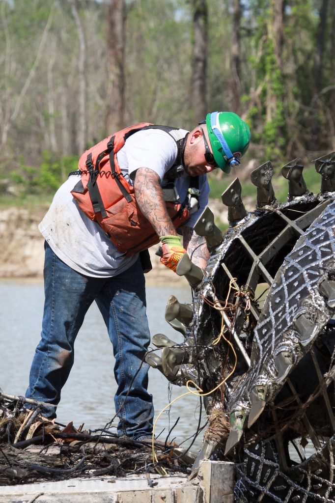
When that happens, productivity slows and crews must manually pick the material from the chisels on the dredge.
Note the pile of roots and sticks growing the men.
Here you get a better idea of how the roots and vines can clog the intakes on the cutter head. Dredging needs to stop many times each day to remove this material.
The “chisels” on the cutter head break up sand which the “cutter basket” then sweeps up. Pumps inside the steel cage suck the sand into the pipe and pump it back upstream to placement areas.
Once the dredge starts pumping again, the flow must be calibrated with three booster pumps attached to each line. At least one crew member mans each booster pump to coordinate with the others. They must avoid over- or under-pressure situations.
This shows a close up of one of the three booster pumps used by Great Lakes, the Army Corps’ lead contractor on the job. Callan Marine is a subcontractor to Great Lakes and also has three booster pumps.
This shot gives you an idea of how massive these pipelines are…
…and how much sediment they can pump per minute. There’s enough sediment moving here to fill up a dump truck in less than a minute.
The Eagle Sorters Mine is dredging this pit even as Army Corp contractors fill it up. Sand and silt recovered from the river may wind up in roadbeds or be used for mortar in the construction trades.

1.4 Million Cubic Yards Recovered to Date

Corps Engineers said that since Sept. 20, 2018, approximately 1.4 million cubic yards of Hurricane Harvey silt and debris have been pumped into the two placement areas. Ultimately, they expect to pump approximately 1.8 -1.9 million cubic yards to meet FEMA requirements, restore the river to pre-Harvey conditions, and to reduce flood risks.

Safety Warning

These images illustrate why boaters should stay away from the West Fork for now. It’s not safe. The FEMA funded emergency flood action should complete in early May, 2019.

Posted by Bob Rehak on 4/3/2019 with images courtesy of the Army Corps of Engineers

582 Days since Hurricane Harvey


Placement Area #1 Filling Up Quickly

As dredging on the West Fork of the San Jacinto gets closer and closer to completion, placement area #1 (PA1) is filling up quickly. Callan Marine, the company operating the dredge near Kings Harbor, is pumping its spoils to PA1. PA1 is an old sand pit off Townsend in Humble near North Houston Avenue.

Pipe Big Enough to Hold Two Basketballs Side by Side

I photographed the tail end of their pipeline this morning. The outflow was impressive. Callan uses 20 inch pipe. To put that in perspective, a basketball has a diameter of about 9.5 inches. So two basketballs could go through this pipe side by side with an inch to spare.

Equivalent of Filling Dump Truck Every Minute or Two

Dredgers measure output in cubic yards per hour. The output varies constantly depending on dredging location and conditions. Callan averages between 280 and 600 cy/hr. If the average dump truck holds about 10 cubic yards, that means this pipe could fill up about 30 to 60 dump trucks per hour, or one every minute or two. That explains why they pump via pipeline instead of using dump trucks.

Close up of 20 inch pipeline spewing sand, silt and clay into old sand pit near Townsend and North Houston Avenue in Humble.
Wide shot of same pit shows a little room left for storage near the perimeter in background.

Mouth Bar Update

The Corps expects dredging to complete around May 4. By contract the dredgers then have 30 days to remove their equipment (dredges, pipeline, booster pumps, pontoons, crew boats, etc.) from the river.

That means the deadline is fast approaching to do something about the mouth bar if we want to avoid a remobilization charges for a second job.

This week, according to Houston City Council Member Dave Martin, the City submitted its coring analysis of the mouth bar to FEMA and a storage permit application to the Corps. FEMA and the Corps have not yet approved either.

Mouth bar of the West Fork of the San Jacinto creates a backwater effect that contributes to flooding.

The City reportedly has talked to the dredging companies about delaying demobilization if the City cannot get approval of FEMA funding and a storage permit before the end of dredging.

Posted by Bob Rehak on 3/29/2019

577 Days since Hurricane Harvey

Huberty Proposes Amendment to Appropriations Bill that Would Allocate $30 Million to Dredge Mouth Bar

Senate Bill 500 is an omnibus appropriations bill passed by the Texas Senate on March 13. The bill passed to the House for committee review and consideration the same day. Last Friday, March 22, State Representative Dan Huberty offered an amendment to SB 500. It would allocate $30 million to dredging the mouth bar where the West Fork of the San Jacinto meets Lake Huston.

Text of Huberty Amendment

The text reads:

“Out of the funds appropriated in Subsection (1), $30 million dollars is dedicated to the Texas Water Development Board to provide a grant to Harris County for the purchase and operation of equipment to remove accumulated siltation and sediment deposits located at the confluence of the San Jacinto River and Lake Houston.”

Great News for West Fork Residents

This is great news for Lake Houston and West Fork residents. We faced six floods last year on relatively small rains. The mouth bar and other sediment dams left by Harvey created backwater effects that exaggerated flood heights. The exaggerated response of the river to these modest rains forced the City to prerelease water to avoid flooding.

It’s not clear how much funding the City will get from FEMA, if any, to address the mouth bar. The two sides have been arguing for more than a year about how much of the sediment is due to Harvey. Stephen Costello, the City’s Chief Recovery Officer, told a town hall meeting in Kingwood last week that there was at least 1.5 million cubic yards of sediment that needs to be removed to restore the river’s natural conveyance. Local geologists estimated that at least a third of that was due to Harvey.

Matching Funds for County

Last year, the County Flood Bond approved by voters in August included a $10 million match for dredging of the East Fork, West Fork and Lake Houston. The project description read: “Potential partnership project with the City of Houston, Coastal Water Authority, and the State of Texas to permit, design, and complete dredging of the East Fork, West Fork and Lake Houston area waterways to reduce flooding risks.”

The County expected to provide one-fifth of the total $50 million projected cost.

If the Huberty amendment and the appropriations bill pass, suddenly we have a clear path to funding… regardless of what FEMA does and how long it takes their money to get here.

Includes Purchase of Equipment

The Huberty amendment calls for the purchase and operation of equipment. That means the equipment could be owned and used wherever needed. For about a year, the Army Corps has emphasized the need for maintenance dredging to prevent re-accumulation of massive deposits.

Matching Funds Mean Higher Priority

There’s a lot to like about this simple amendment. Consider this. Many have worried lately about prioritization of flood bond projects, i.e., which would kick off first. Readily available matching funds would give the dredging project a very high priority. That would accelerate execution of the project.

Posted by Bob Rehak on March 25

573 Days after Hurricane Harvey

Yes, They’re Selling the Sand, Too!

On Tuesday this week, I created a post in response to a question about whether they really were taking sand out of the river. Someone thought the presence of dredges on the river was a government hoax because they didn’t see any trucks carrying sand away. Shades of Roswell and UFOs!

I explained that they were pumping it back upstream to sand pits via submerged pipelines. Placement Area #1 (PA 1) is an old pit no longer in active use. Placement area #2 (PA 2) is an active sand mine south of Kingwood College on Sorters Road.

Quantities Dredged to Date

According to Al Meyer, the Army Corps Project Manager, dredged material placed in the pits to date is approximately 418,000 cubic yards at PA 1 and 825,000 cubic yards at PA 2. That’s about two-thirds of the total estimated volume of 1.9 million cubic yards for the entire project.

Second-Hand Sand

Dozens of readers complained that they weren’t selling sand from the placement areas. Their concern: that it could wash right back into to the river. Most people wanted to see it put to use somehow…as fill for foundations, in concrete, etc…outside of the flood plain.

The Army Corps contract gives dredging companies and landowners the right to sell the material pulled out of the river. (See SECTION 02 41 01.01 45 Page 4 ) But were they? I asked the Corps. Here’s what I found out.

Placement Area #1

The abandoned pit south of the river is filling up quickly. So far, no sand has been sold from tha as far as I know and the Corps did not return a phone call on that subject.

Unconfirmed rumors say that the landowner may keep the sand and build on top of it. It certainly appears that way. I see no sorting or loading equipment on site. One bulldozer keeps relentlessly moving around, spreading and leveling the sand that has piled up. However, it could be mined and resold at a later date if the owner chooses.

At Placement Area #1 on Townsend, a bulldozer is spreading the sand around and packing it down.

Placement Area #2 on Sorters

The active pit on Sorters has received about twice as much material as the inactive pit on Townsend. But it is not filling up as quickly. That’s because they’re selling the sand.

Placement area #2. Dredged material flows in at the left and spreads out in the pit.

As it enters the pit, a dredge sucks it up and sends it to machines that cleans and sorts it. The mine then sells the coarse sand for use in concrete. They sell the fine sand for mortar in the construction trades, fill and pipeline bedding.

From there, a dredge sucks it up for cleaning, sorting, stockpiling and transportation.
Placement area #1 does not have all this equipment.

Free Use of Land In Exchange for Right to Sell

According to the Corps’ Lt. Col. Williford, the sand mine operators offer the free use of their land for storage in exchange for the right to sell the material. This seems fair. It keeps the cost to taxpayers down. The material is put to good use. And, at least in the case of PA2, they are removing it from the flood plain.

Posted by Bob Rehak on 3/15/2019

563 Days since Hurricane Harvey

Yes, They Really Are Moving Sand Out of the River

At a community meeting last night, someone asked whether the Army Corps was REALLY taking sand out of the river. They didn’t see any dump trucks and they were concerned that the project was just a big hoax, on the order of Roswell, aliens and UFOs.

You have no idea how often I hear comments like this! Where are they putting all the sand? How does it get there?

Yes, they really are moving sand out of the river. But it’s not with trucks. Two dredges are pumping it though 24-inch pipe and six booster pumps miles upstream. One dredge is south of the Kingwood Country Club. The other is just east of Kings Harbor.

The first dredge is pumping sand back to an abandoned sand pit south of Kingwood College on Sorters Road. The second dredge is pumping it back to a pit on Townsend Boulevard in Humble. Here’s what it looked like today at the Townsend Pit.

Placement Area #1 on Townsend in Humble just east of North Houston Avenue. The old sand pit is nearly full.
Keeping the sand evenly dispersed is a challenge. Bulldozers keep it from building up near the pipe on the left.
Placement Area #1 is almost filled.

After the sediment drops out of suspension and settles to the bottom of the pit, sediment-free water returns to the river through this drain.

Picture of pit taken in October 2018 as dredging was beginning. The pit is now almost completely filled.
It takes six booster pumps and five miles of pipeline to get the sand where it’s going.
Before the job is done, the Army Corps will have picked up a volume of sand equivalent to the Astrodome and moved it five miles.

Posted by Bob Rehak on 3/12/2019

660 Days After Harvey

March 4 Dredge Update

The U.S. Army Corps of Engineers supplied this graphic. It updates the public on the latest dredging progress.

Two dredges, moving west to east (left to right), expect to complete dredging by the end of April, seven weeks from now. It was originally a nine month project scheduled to end around April 1, but heavy weather and multiple floods during December and January set the contractors back.

Great Lakes Dredge and Dock operates the red dredge that started at River Grove Park and is working its way toward the project midpoint.

Callan Marine operates the blue dredge that started at the midpoint and is working its way toward the end.

With roughly 50 days remaining (about 15-20% of the time depending on how many weather days you allow), the corps appears to be about 70% done. That means they must hustle to make up time. The contractors are already working 24/7.

Parents who want to give their kids a treat can take them down to Kings Harbor to watch the dredging. I was there today. It is truly impressive. There’s lots of big equipment on the river moving more sand than the Astrodome can hold. They’re pumping it miles upriver to two old sand pits.

While at Kings Harbor sample some frozen yogurt or one of the restaurants that recently re-opened. Please support the local merchants who bet their financial futures to make your life a little more enjoyable.

Posted by Bob Rehak on 3/7/2019

555 Days since Hurricane Harvey

Army Corps Updates West Fork Dredging Progress

The US Army Corps of Engineers has just released a graphic that updates the Lake Houston Community on West Fork dredging progress. With a little more than two months to go before the scheduled completion of the project, about two thirds of the work has been completed. That’s a visual estimate, not one based on volume of sand removed.

The clock started ticking on this project on July 15, 2018. The contract called for completion in 270 days or about mid-April. However, contractors encountered three back-to-back-to-back floods in December and January that set them back. The Corps’ last scheduled completion date was at the end of April.

The dredging progress may be slightly behind schedule, even given the addition of the “weather days.” However, contractors hope to make up the time as weather improves.

Work to date shown in solid colors. Unfinished work shown as empty boxes. Expected completion date is end of April.

To download a high-resolution version of this progress map, click here.

Artwork courtesy of the U.S. Army Corps of Engineers.

Posted by Bob Rehak on 2/21/2019

541 Days since Hurricane Harvey