The Texas General Land Office (GLO) announced today that for the first time ever since Hurricane Harvey, both Houston and Harris County have each met their benchmarks for expending disaster relief funds – in the SAME time period. They may have individually met performance benchmarks before, but never together in the same review period.
Both Harris County and Houston have semiannual expenditure benchmarks in their Community Development Block Grant Disaster Relief funding contracts with the GLO, per HUD guidance. “These milestones were set by the City and County and approved by the GLO to ensure all programs will be completed as timely as possible,” said a GLO spokesperson.
A New Era of Cooperation Yielding Results Already
Dawn Buckingham, M.D., the new GLO Commissioner credits open communications and focused cooperation. “The GLO is dedicated to helping Harris County and the City of Houston put these vital funds to good use.”
GLO Commissioner Dawn Buckingham, M.D., speaking at a joint press conference in March. Others L to R: Harris County Community Services Interim Exec Director Thao Costis, HCFCD Exec Director Dr. Tina Petersen, P4 Commissioner Lesley Briones, P2 Commissioner Adrian Garcia, P3 Commissioner Tom Ramsey PE, P1 Commissioner Rodney Ellis, County Attorney Christian Menefee.
This is good news. In years past, the relationship between Houston, Harris County, GLO and HUD foundered over performance benchmarks, cooperation and communication. But now, new players are in place. And 5+ years after Harvey, the City, County and State all face “use it or lose it” deadlines from HUD.
More Money Hangs in Balance
While the performance benchmarks in question have to do only with unexpended, Harvey-related, disaster-relief funds, much more money hangs in the balance.
Earlier this month, HCFCD presented Commissioners Court with a proposed project list for those funds. HCFCD is reportedly still trying to define the areas benefited by each of those projects before final approval. However, HUD and the GLO seem pleased with both the progress and the collaborative working relationships that have developed.
Everyone seems to respond positively to Dr. Buckingham’s working style – described as “supportive,” yet “results oriented.”
Commissioner Adrian Garcia stated publicly, “I want to give a shout out to the GLO and Commissioner Buckingham for her support of Harris County and giving us a degree of trust.”
Commissioner Tom Ramsey complimented the fairness of project list, noting that it worked out to about 25% for each precinct. He stated, “job well done by the whole.”
Commissioner Lesley Briones said, “This is so wonderful that we were able to hit reset and really focus on the progress going forward.”
Nature Provides Its Own Deadlines
It can’t happen soon enough for Harris County residents who live under constant threat of floods. Monday afternoon, Tropical Storm Brett formed in the Atlantic. Another storm with an 80% chance of formation in the next 7 days follows closely behind. That’s up from 50% yesterday afternoon.
National Hurricane Center update as of 10:45AM EDT Tuesday, June 20, 2023
It’s too early to tell with any reliability where/whether/when either of these disturbances will make landfall.
Posted by Bob Rehak on 6/19/2023
2120 Days since Hurricane Harvey and Updated on 6/20/2023 with new storm information and photo.
https://i0.wp.com/reduceflooding.com/wp-content/uploads/2023/06/20230620-image0.jpg?fit=1100%2C824&ssl=18241100adminadmin2023-06-19 16:57:252023-06-21 22:08:33A First: Houston, Harris County Both Meet HUD/GLO Disaster-Relief Benchmarks in Same Time Period
Despite well intentioned efforts to help limit the growth of impervious cover, the Commission has not conducted a flood study showing the cumulative impact of its recommendations.
Nor does it have any concrete recommendations guaranteed to make housing more affordable – its primary goal.
Effects on Affordability Uncertain
Most of the ordinance changes would let people build more housing in any given area. Changes would allow:
More compact development and small-scale, multi-unit housing
On less land
With fewer parking spots
And with narrower driveways.
Housing variations encouraged by Livable Places increase housing density and impervious cover.
Those recommendations have the potential to reduce redevelopment costs and therefore exert downward pressure on housing prices. Land represents a significant percentage of those housing prices. Also, it takes less labor and fewer materials to build a 1,000 square-foot home than it does a 2,000 square-foot home. But…
How much of those savings will buyers receive and how much will developers pocket?
Higher density also lets more people share the cost of infrastructure, such as streets and storm sewers. That theoretically exerts downward pressure on prices, too.
But higher runoff associated with more impervious cover could exceed the capacity of those storm drains and ditches. And that could lead to increases in drainage fees.
During the public comment period after the last Planning Commission meeting, one individual referenced outrageous prices for densely packed, small homes in the Heights (see below). He made the point that nothing in the regulationsguarantees more affordable housing.
Many of the targeted inner-city neighborhoods already complain about flooding and blame it on historical discrimination. Any increase in impervious cover could make such neighborhoods less livable, not more.
Houston Already Has More Affordable Homes and People Still Move Out
The Planning Commission is filled with bright, intelligent, hard-working people. But they have limited tools at their disposal. While they may be able to make housing more affordable, they have no tools to fight crime, flooding, or failing schools.
Houston already has some of the most affordable housing in the region. Yet people still move out of the City to buy higher priced homes.
While population in the region is increasing, population in the City of Houston has decreased since the 2020 census.
Census estimates show the City’s population went down by 0.1% during that period.
During that same period, Montgomery County grew by 9.4% and Fort Bend County by 8.1%.
Usually, higher prices limit demand and lower prices increase it. But that isn’t happening in the Houston region.
According to the Census Bureau, the average house price in:
Houston = $200,000
Conroe = $223,300
Katy = $290,200
Sugar Land = $334,000.
Houston already has the lowest housing prices!
If people were looking purely for more affordable housing, you would expect Houston’s population to increase, not decrease.
But what do the high-growth areas have in common? They tend to be suburban with single-family homes that offer yards; a safe environment to raise kids; good schools; easy access to shopping and ample parking.
Perhaps the Planning Department needs to take a broader look at what attracts people and build that into its Livable Places Initiative.
Aerial Photo taken in 2022north of Houston’s downtown.
In the picture above, note how some blocks have more green space than rooftops, others are entirely covered by rooftops.
Redevelopment under the new rules will bring more of the latter, not the former.
Saving the Green
Denser housing also means fewer trees. According to the EPA, “Trees are increasingly recognized for their importance in managing runoff.”
Leaf canopies help reduce erosion caused by falling rain.
Rain water can land and evaporate from more surface area.
Roots take up water and help create conditions in the soil that promote infiltration.
Trees stabilize soil and help regulate streamflow by reducing the velocity of water entering streams.
Yes, trees play a vital role in reducing flooding.
Planning Department staff are fond of saying that higher density housing in Houston will help prevent the clearcutting of forests in outlying areas and, thus, reduce flooding. “Build more homes where the infrastructure already exists,” they argue.
There is, no doubt, some truth to that – especially on a macro level. Conservation and preservation make valuable flood-fighting tools. But…
Saving trees in one watershed won’t reduce flooding in another.
We need to practice conservation and preservation everywhere – to the extent possible – especially where people are flooding – in Houston.
YIMBY vs. NIMBY
Still, people need homes. And the cost of housing has clearly priced some people out of the housing market. According to the Census Bureau, a generational divide underlies the pricing divide. The housing shortage is dire in many metropolitan areas.
Older baby-boomers may abhor the type of development seen above. They’re literally saying NIMBY (Not in My Backyard!) to garage apartments, infill development and other types of housing encouraged by Livable Places.
But a younger group of millennials who find themselves priced out of the housing market are saying YIMBY (Yes in My Backyard).
Across the nation, renters, are especially cost burdened. The U.S. Department of Housing and Urban Development (HUD), says anyone who spends more than 30 percent of their income on housing is cost-burdened. Nationally, an estimated 40 percent of rental households and 21.3 percent of households with a mortgage met this threshold in 2018 – when Houston was revising building codes to help prevent another Hurricane-Harvey-type scourge.
One Crisis Vs. Another Crisis
Houston has averaged 3-5 flooding crises, on average, every decade for more than a hundred years. We saw eight in the last decade alone.
Now we seem to be solving a housing crisis with little regard for the predictable flooding crises we know will strike us. How soon we forget!
City Council Will Vote on Wednesday
City Council will vote on the “Livable Places” recommendations on Wednesday, 6/21/23. The Planning Commission website explains how you can sign up to speak.
ReduceFlooding.com recommends that City Council does NOT approve “Livable Places” recommendations until any potential impact on flooding is known and residents can decide whether the potential increased risk is worth any benefits developers may gain.
Posted by Bob Rehak on 6/18/23
2119 Days since Hurricane Harvey
The thoughts expressed in this post represent opinions on matters of public concern and safety. They are protected by the First Amendment of the US Constitution and the Anti-SLAPP Statute of the Great State of Texas.
https://i0.wp.com/reduceflooding.com/wp-content/uploads/2023/06/Screenshot-2023-06-18-at-1.04.08-PM.png?fit=2224%2C1472&ssl=114722224adminadmin2023-06-18 14:16:532023-06-18 19:49:39Would Livable Places Initiative Really Make Housing More Affordable?
Second in a series on the Houston Planning Commission’s Livable Places Initiative
“Livable Places” is a new initiative by the City of Houston Planning Commission designed to increase housing affordability and equity while increasing the walkability of neighborhoods.
To achieve these goals, the Commission is recommending new rules that govern development, platting and parking. They would also result in greater housing density especially in inner city neighborhoods. However, they affect the entire city.
Moreover, greater density usually comes at the expense of more impervious cover, which contributes to flooding. Despite several attempts to minimize the growth of impervious cover, the Planning Commission has not studied what the aggregate impact could be.
City Council will consider approval of the recommendations on Wednesday, 6/21/23. This Planning Commission website explains how you can sign up to speak.
ReduceFlooding.com recommends that City Council does NOT approve “Livable Places” recommendations until any potential impact on flooding is known and residents can decide whether the potential increased risk is worth any benefits developers may gain.
Proposed Changes
Specifically, ordinance changes to Chapters 42 and 26 of the City Code would allow:
Second Dwelling Unit: Lets this housing type be larger with parking based on the unit size. Think of apartments over garages or small backyard homes. Only available where deed restrictions do not prohibit their construction.
Multi-Unit Residential: Brings back this affordable housing type which is small scale 3–8-unit apartments with a height restriction to fit better within neighborhoods.
Courtyard Style Development: Promotes this housing type where lots are located around a common courtyard, and do not require street frontage. The proposal includes green space requirement per lot, parking could be separate from the units and height restriction so that homes are at neighborhood scale.
Narrow Lot Development: Incentivizes this housing type where lots take rear access or shared access to reduce the number of times pedestrians come in potential conflict with automobiles. In addition, these regulations help the redevelopment be more walkable by reducing the driveway widths and preventing vehicles from hanging into the sidewalk.
Market Based Parking: For all the four residential development types mentioned above, the proposal is to allow market-based parking in proximity where other transportation options exist and make housing affordable. This means the City will not have a minimum parking requirement, and the property owner can provide parking based on market needs.
Impervious-Cover Impact Unknown
The recommended changes encourage greater density by allowing subdivision of lots. That generally means more rooftops and concrete per acre. Rooftops and concrete are called impervious cover because they do not let stormwater soak into the ground.
Here are the proposed changes to ordinances. They mention impervious cover only once – in the context of courtyard development. And that mention says, courtyards “may be a mix of impervious or pervious material…” They specify no percentages.
Neither do they mention pier-and-beam foundations that could elevate new buildings above flood risk without reducing floodplain storage. Any reduction in the volume of floodplain storage could affect the flood risk of existing homes.
Several department spokespeople pointed out, however, that any development would have a 65% cap on impervious cover. Above that, developers would have to build stormwater detention basins. But the wording of that requirement is reportedly being reconsidered at this time by the Public Works Department.
The Planning Commission did not conduct a comprehensive engineering study to estimate any increase or decrease in impervious cover associated with the recommended changes. That raises the question:
Will impervious cover increase, decrease or stay the same?
The City knows how much impervious cover we have now because the City charges us a Drainage Fee for it. And even though the City cannot predict which types of housing developers will want to build and in what quantities, it could easily calculate the increase or decrease for representative scenarios and make guesstimates.
But we may not know a definitive answer for decades until the impact of these recommendations become visible on the ground or during the next large flood.
Fortunately, the Planning Commission has recommended several changes that may help offset increases in density. They include, but are not limited to:
Elimination of some mandatory parking requirements in neighborhoods where car ownership is low and access to public transportation is high.
Making greater use of alleys to preserve green space in public right of way at the front of lots.
Allowing shared driveways that are narrower than two individual driveways.
Density, Impervious Cover and Drainage Fees
Back in 2010, the City taught us that impervious cover was bad. The City even created a fee to discourage it called the Drainage Fee. Since then, the City has collected 3.2 cents per square foot of impervious surface from each home and business owner with curb and gutter drainage in the City. Those with street ditches pay a slightly lower rate. The total collected to date is reportedly approaching $1.3 billion.
Aerial Photo taken in 2022north of Houston’s downtown.
The proposed changes could make neighborhoods like the one above even denser and tax the capacity of storm sewers/roadside ditches even more. Many of the ditches are already blocked and in serious need of restoration.
Adding more homes per acre in areas with drainage that’s already poor could increase flood risk for existing residents.
More Resources
To learn more about the Planning Commission’s Livable Places initiative and what the Commission believes to be the benefits, visit these resources.
Livable Places does have the potential to provide some benefits to some market segments. So to make sure we get this right, I encourage comment from members of the planning commission, local governments, affected citizens, and flood experts. To submit a guest editorial, reach out to me through the Contact page of this website.
Posted by Bob Rehak on 6/16/2023
2117 Days since Hurricane Harvey
The thoughts expressed in this post represent opinions on matters of public concern and safety. They are protected by the First Amendment of the US Constitution and the Anti-SLAPP Statute of the Great State of Texas.
They would do that by encouraging more housing density – and potentially more impervious cover – in neighborhoods already prone to flooding.
While regulation changes would apply to the whole city, they would primarily increase housing density in “public-transit-rich” areas inside the Beltway. There, the new regs would even let developers avoid building parking so they could increase housing density more.
Compare the three maps below. The first shows flood damage in all storms from 1999 to the month before Hurricane Harvey.
From a 2018 Rebuild Houston presentation.Note the preponderance of damage inside the Beltway.
The second shows damage during Hurricane Harvey.
From 2019 HCFCD Federal Briefing. Again, note the preponderance of damage inside the Beltway.
Compare those maps to this one created by the Planning Department for the Livable Places Initiative. It shows transit-rich areas where parking requirements would be optional for developers, allowing even more housing density – inside the Beltway.
Screen capture from the Livable Places presentation to the Planning Commission on 6/8/23.
Preamble to City Council Resolution Clarifies Targeted Area
Encourage more compact development patterns and small-scale, multi-unit housing options
Make better use of land closer to existing infrastructure
Promote responsible, affordable housing development “within the inner city.”
The graphic below shows the housing types that Livable Places will encourage. Each involves putting more people on any given lot, acre, or square mile.
Screen capture from presentation to Planning Commission on 6/8/23
In summary, the Planning Commission hopes to increase density in areas with the worst history of flooding in Harris County – in the name of equity. And they do that even as Harris County struggles to mitigate flooding in those same areas – also in the name of equity.
My head is spinning. Where is Daniel Webster when you need him!
Learn More During “Livable-Places” Week
The City Council still needs to adopt these regulations before they become effective. The Planning Commission hopes to bring them before Council later this month or early next. Before then, I will cover:
More details of the plan and attempts to offset increases in impervious cover
The unknown, cumulative impact of recommended changes on impervious cover
The City’s Drainage Fee which penalizes impervious cover by increasing residents water bills
Whether proposed changes will really make housing more affordable
Migration patterns within the city and region, and the demographic changes affecting them.
Livable Places does have the potential to provide some benefits to some market segments. So to make sure we get this right, I encourage comment from members of the planning commission, local governments, affected citizens, and flood experts. To submit a guest editorial, reach out to me through the Contact page of this website.
The thoughts expressed in this post represent opinions on matters of public concern and safety. They are protected by the First Amendment of the US Constitution and the Anti-SLAPP Statute of the Great State of Texas.
https://i0.wp.com/reduceflooding.com/wp-content/uploads/2023/06/Rebuild-Houston-Flood-Damage-Repetitive-Loss-Map.jpg?fit=1100%2C617&ssl=16171100adminadmin2023-06-13 17:38:122023-06-18 22:13:01Livable Places Initiative Would Create Higher Density in Flood-Prone Areas
Concrete reinforcements under and on both sides of the bridge have collapsed from undercutting, erosion and jetting.
The stream has downcut, exposing pipelines.
Jetting has carved out a cavernous area south of the bridge.
Erosion has reached within a few feet of a utility corridor.
Storm sewer outfalls have been exposed, undercut and punctured by massive slabs of displaced concrete.
Bridge supports, once protected by sidewalls, have been exposed to more erosion.
Pictures Taken on 6/12/23 Show Extent of Damage
The bridge will probably not collapse in the next big rain. However, the cumulative damage to all these components underscores the need for urgent repair. It also underscores the need for mitigation to reduce the jetting that caused the damage.
Looking NE at downstream, eastern side of Tree Lane bridgeWider shot from same position reveals two exposed pipelines.Looking upstream under Tree Lane Bridge. Note how downcutting threatens western (left) wall also.Giant slabs of concrete have destroyed outfall.Erosion downstream of the Tree Lane bridge now is within approximately ten feet of a utility corridor.
Damage Accelerating, Repaired Just Three Years Ago
The city repaired the Tree Lane Bridge in March of 2020. Compare this post to see how it looked then. It’s amazing how much damage could be done in three years to a bridge that weathered multiple hurricanes and tropical storms for more than 50 years.
That’s a testament to insufficiently mitigated development upstream that sends ever greater volumes of water downstream – more than the opening under the bridge was designed for.
For a description of how jetting works, check this post. Basically, water backs up behind the bridge, putting greater pressure on the water flowing under the bridge.
Let’s hope the City can repair the Tree Lane Bridge again before school starts in the fall. The bridge borders Bear Branch Elementary School where 638 students attend classes.
Please check bridges near you and report any damage.
Posted by Bob Rehak on 6/12/2023
2113 Days since Hurricane Harvey
https://i0.wp.com/reduceflooding.com/wp-content/uploads/2023/06/20230612-DJI_0007.jpg?fit=1100%2C733&ssl=17331100adminadmin2023-06-12 21:28:172023-06-13 09:04:40Flood Damage To Tree Lane Bridge Over Ben’s Branch Accelerates
Stormwater can cause more than flooding. For all those headed to the beach this summer, the Texas General Land Office (GLO) offers a useful website that monitors water quality and safety. It’s called Texas Beach Watch.
About Beach Watch
The program tests bacteria levels at beaches along the coast and Galveston Bay. It measures Enterococcus bacteria (fecal indicator bacteria) levels every week from March through October and every other week during the rest of the year.
Why Enterococcus Matters
So what is Enterococcus and where does it come from?
Enterococcus indicates the presence of fecal matter. And according to the U.S. Environmental Protection Agency, sources include stormwater runoff plus:
Wastewater treatment plant effluent
Leaking septic systems
Sewage discharged or dumped from recreational boats
Domestic animal and wildlife waste
Improper land application of manure or sewage
Runoff from manure storage areas
Pastures
Rangelands
Feedlots.
EPA also lists natural, non-fecal sources of fecal-indicator bacteria. They include:
Plants
Sand
Soil
Sediments.
The latter contribute to a certain background level in ambient waters and vary based on local environmental and meteorological conditions.
Health and Recreation Consequences
The EPA says such pathogens can sicken swimmers and others who use rivers and streams for recreation or eat raw shellfish or fish. Other potential health effects can include diseases of the skin, eyes, ears and respiratory tract.
The EPA also says that enterococci are typically not considered harmful to humans, but their presence may indicate the presence of other disease-causing agents such as viruses, bacteria, and protozoa.
Overabundance of fecal bacteria in the water can cause beach closures, swimming and boating bans and closures of fishing and shellfishing areas.
Three Warning Levels and Today’s Readings
The Environmental Protection Agency (EPA) recommended single sample maximum criterion for Enterococcus bacteria is 104 colony forming units (CFU) per 100 ml. When the counts are above this level, swimming is not recommended.
The GLO rates bacteria levels at beaches as follows:
Low Bacteria counts less than 35 cfu/100 ml.
Medium Bacteria counts are between 35 and 104 cfu/100 ml.
High Bacteria counts are greater than 104 cfu/100 ml. An advisory for this beach is recommended.
Here’s what the coast looked like along the coast this morning.
Galveston looked pretty safe with the exception of two cautions.Bolivar had more cautions and an advisory.
For More Information,
For more information, please review the health risks associated with swimming in waters with high Entercoccus counts in Pathogens & Pathogen Indicators.
If you have a favorite beach, the GLO’s TexasBeachWatch.com website lets you sign up for alerts.
Posted by Bob Rehak on 6/10/2023 based on information from the GLO and EPA
2111 Days since Hurricane Harvey
https://i0.wp.com/reduceflooding.com/wp-content/uploads/2023/06/Screenshot-2023-06-10-at-1.05.56-PM.png?fit=1854%2C1056&ssl=110561854adminadmin2023-06-10 14:01:302023-06-10 14:06:12Check This Website Before Heading to the Beach
The Kingwood Middle School reconstruction project is nearing completion. The new stormwater detention basins are complete, grassed in, and virtually fenced. The athletic fields have been laid out. And the track is under construction. The photos below show what the project looked like on 6/9/23.
The new KMS track and football field will go where the old school was. The detention pond, framed by trees, will help screen afternoon activities from neighbors.The pond already sports grass on the banks to retard erosion.Looking west toward Cedar Knolls.The detention basin gets an A for the most creative shape.Such basins do not have to look ugly.Lower angle shows that the basin will enhance the south entry and provide a restful look. The black wrought-iron fence looks gorgeous. And it will keep kids out of mischief.
Humble ISD has created an architectural gem in the new Kingwood Middle School. The District hopes to complete the project soon. The school itself opened in August 2022.
Posted by Bob Rehak on 6/9/2023
2110 Days since Hurricane Harvey
https://i0.wp.com/reduceflooding.com/wp-content/uploads/2023/06/20230609-DJI_0995.jpg?fit=1200%2C799&ssl=17991200adminadmin2023-06-09 19:56:582023-06-09 19:56:59Kingwood Middle School Detention Ponds Complete, Athletic Fields Started
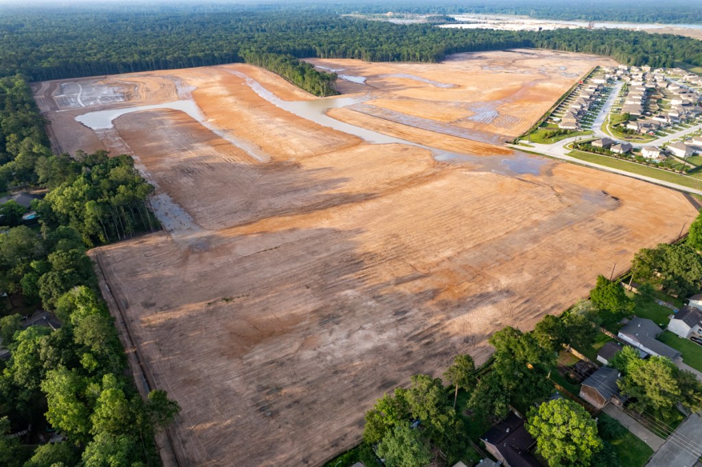
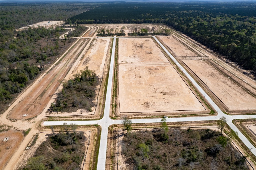
For a variety of reasons, many new developments seem to be “on pause” these days. Developers clear and grade land. Then it may sit undeveloped for months or even years.
This leaves exposed soil unprotected by vegetation. That makes it more susceptible to erosion for longer periods. And the eroded soil can clog streams and creeks with excess sediment. That reduces conveyance and can contribute to potential flooding. The EPA classifies sediment as the most common pollutant in American rivers and streams.
I am not alleging that all of the developments below have flooded other properties – though some have. But in extreme storms, they may contribute to conditions that increase flood risk.
That raises the question: Can we reduce that risk? That, of course, requires understanding what’s slowing development. But let me show you some examples of stalled developments first.
Unprotected Soil
No one keeps statistics on how long cleared land remains undeveloped. But suddenly, it feels as though stalled developments surround us. Below are pictures of just a handful taken in the last few months near the Montgomery/Harris County border.
Royal Pines in Porter
Royal Pines in Montgomery County on White Oak Creek has flooded neighbors’ properties multiple times in the last six months. White Oak Creek actually rerouted itself across a portion of the development.Royal Pines border with White Oak Creek (in woods). Note sediment escaping propertyinto creek.After a 4-inch rain in January, White Oak Creek branched and started flowing across the cleared area.Truck of Royal Pines neighbor one day after being washed.Flooding isn’t the only problem.
The neighbor stated that she spoke with the MoCo Engineers’ office last Friday and the stormwater detention plan still had not been approved. According to the neighbor, the developer was told by the county last January to submit revised detention and berm plans. The engineer also requested the developer to divert the runoff away from the neighbor’s property. But the developer evidently went ahead and built a detention basin without revising the plans. The development still floods neighbors’ property after every appreciable rain.
New trailer park development in NW Harris County is sending sediment into the headwaters of Spring Creek. See below.
As you approach the creek, the slope increases…
…and despite the best efforts of the developer, sediment is escaping into the creek.A river of mud……is flowing into Spring Creek.
Townsen Landing in Humble
A small part of Townsen Landing in Humble. The developer cleared land, but no homes have been built in the last year.
Valley Ranch in New Caney/Porter
Valley Ranch Medical Center construction in November 202120 months later they were building detention basins and channels to connect them. In March 2023, uncontrolled runoff was sending sediment into a ditch behind homes and businesses along FM1314.
Multiple Reasons for Development Delays
To do something about development delays, you need to understand the causes first. Those most often cited by developers and media have to do with:
Regulations. For instance, Magnolia officials enacted a moratorium on permit applications in December 2022 over concerns the city’s water supply couldn’t keep pace with growth in the area. The moratorium impacts new as well as current development projects.
Developers rank permitting delays as one of their biggest headaches.
Increasing land prices push developers into marginal, flood-prone land as a way to help control costs. But such land also causes permitting delays. Developers struggle with extra layers of studies and approvals from flood plain managers that can slow projects.
Rising interest rates that may undermine developers/builders economic assumptions.
Shortages of building materials. For instance, a global cement shortage, often linked to the war in Ukraine, makes planning difficult for land developers and road builders. According to a source at the Houston Contractors Association, Texas pours more concrete annually than the next two states (CA and FL) combined.
The pandemic, which led to other supply and labor shortages.
Such issues often loom larger for less experienced developers whose pockets may not be as deep as their more experienced competitors.
Regardless, silt fences are woefully inadequate in dealing with issues such as these.
Need to Re-Evaluate Construction and Permitting Practices
Some suggestions. Many areas do not require a permit to clear and grade land. Developers may begin the process assuming normal permitting time for their plans, but then run into unforeseen hiccups. As regulations have gotten more complex in the post-Harvey world, this has become increasingly common. Perhaps we need to require:
Permit approvals before clearing and grading.
Vegetated buffers around the perimeter of properties during development.
Berms to protect neighbors and waterways during development
Clearing and installing drainage in a portion of a property before moving onto another portion of the property (phased development).
Governments throughout the region to standardize construction requirements.
Governments to hire enough people to review plans a timely way.
Some or all of the above.
Other ideas suggested by readers:
Do not develop on land not suited for development in the first place.
Stop developing so close to waterways.
Zone land to allow natural drainage to exist in harmony with human occupancy.
Keep some areas prone to flooding heavily vegetated permanently.
Half Billion Dollars for Sediment Removal
Sound expensive? Consider this.
Since Harvey, we have spent/plan to spend approximately a half billion dollars on dredging and sediment removal. Half of that has been spent on the East and West Forks of the San Jacinto, plus channels/streams around Lake Houston. The other half will be spent on sediment removal in:
Willow Creek
White Oak Bayou
Spring Creek
Little Cypress Creek
Greens Bayou
Cypress Creek
Barker Reservoir
Addicks Reservoir
We must find a compromise that works for everyone. People need places to live. Especially places that don’t flood.
Posted by Bob Rehakon June 7, 2023
2108 Days since Hurricane Harvey
The thoughts expressed in this post represent opinions on matters of public concern and safety. They are protected by the First Amendment of the US Constitution and the Anti-SLAPP Statute of the Great State of Texas.
https://i0.wp.com/reduceflooding.com/wp-content/uploads/2023/06/20221006-DJI_0849.jpg?fit=1200%2C799&ssl=17991200adminadmin2023-06-07 19:53:512023-06-11 13:21:23How Development Delays Can Impact Flooding
On June 6, 2023, Harris County Flood Control District (HCFCD) recommended to Commissioners Court a flood-mitigation and disaster-relief project list totaling $825 million. The U.S. Department of Housing and Urban Development (HUD) allocated the funds to Harris County via the Texas General Land Office (GLO). The projects will require another $145 million in local-match funds from the 2018 Flood Bond. Thus, the projects are worth close to a billion dollars.
Commissioners Court unanimously approved the project list with little discussion. Each precinct will receive a relatively equal amount of projects and funding, according to Commissioner Ramsey.
Racial composition of areas receiving mitigation benefits.
HUD normally gives priority to projects that help minority and low-income areas. However, the two major buckets have different LMI requirements. They also have different deadlines.
HCFCD must spend 100% of the Disaster-Relief (DR) funds by August 2026. And they must benefit areas where 70% of the residents qualify as LMI (below the average income for the region).
The Mitigation funds have more time and a 50% LMI requirement. No less than 50% of the $750,000,000 – from which the $502.5 is carved – must be expended by January 12, 2027, with the full balance expended by January 12, 2032.
So the DR funds have more urgency attached to them and that list includes projects closest to “construction ready.”
Reason for Backup Projects
According to HCFCD, the project list will likely evolve based on review by GLO, project schedules and project costs. Budgets are estimates based upon today’s dollars. They will change as projects advance.
Fatal flaws may also become visible as projects advance toward construction. So, HCFCD requested and received permission to substitute alternate projects as needed if the intended projects become non-viable.
1 Recommended, 1 Alternate Project in Lake Houston Area
The “recommended” list includes one primary project in the Lake Houston Area: Taylor Gully Improvements.
The project list does not include information on how much these projects would contribute to flood reduction – either locally or downstream. However, HCFCD expects to post that information to its website before the projects go to the GLO for approval in the coming months.
Partnership-Funding Gap Affected
Likewise, HCFCD did not include with this list an estimate of how much it would affect the partner-funding gap.
Some time ago, HCFCD projected that it could finish all the projects in the flood bond using a combination of:
But to finish all the projects in the Flood Bond, HCFCD “phased” some projects. It knew it wouldn’t have enough money to complete 100% of some large projects. So, several phases might have been included and others deferred.
It appears that several projects on today’s list include some deferred phases. So the “partner-funding gap” may not be reduced as much as originally thought. Net: HCFCD may or may not have to look for additional funds. The District expects it will know more after GLO approves the list.
HCFCD must also come back to Commissioners Court by July 18 with an estimate for ongoing maintenance and land management costs for all the projects.
Posted by Bob Rehak on 6/6/2023
2107 Days since Hurricane Harvey
https://i0.wp.com/reduceflooding.com/wp-content/uploads/2023/06/Project-Recs.jpg?fit=1200%2C765&ssl=17651200adminadmin2023-06-06 19:32:252023-06-19 14:01:42Harris County Approves $825 Million Flood-Mitigation Project List For HUD/GLO Funds
Harris County Flood Control District’s (HCFCD) Woodridge Village Excavation and Removal contract for 500,000 cubic yards with Sprint Sand & Clay is almost one-quarter complete. Sprint excavated approximately another 9,000 cubic yards in May (5.8 acre feet). That’s almost double the monthly minimum and brings the total up to 123,882 cubic yards.
Stormwater from Woodridge Village flooded hundreds of homes twice in 2019. The excavation will provide additional stormwater detention capacity to reduce flood risk downstream in the future.
May/June Photos Show Progress
The first two photos below were taken at the beginning of May and June 2023.
Looking ENE. Extent of excavation on May 2, 2023Looking ENE. Extent of Excavation on June 4, 2023
Up until now, Sprint has been excavating from west to east. Now, they seem to be excavating primarily from south to north.
HCFCD spokesperson Amy Crouser said that, “Essentially, the contractor is free to excavate where they want within the provided footprint.”
Looking east across new focus of excavation.
Where Does Woodridge Village Excavation Go From Here?
Sprint has excavated 76.8 acre feet so far. That brings the current detention capacity (old plus new) to 348 acre feet. That’s 90% of what Woodridge Village needs to meet Atlas-14 requirements.
If Sprint keeps excavating at the current rate, it could reach Atlas-14 requirements before the end of the year.
Here’s how all that looks in a table.
Acre Feetof Stormwater Detention
% of Ultimate
Site Had When Purchased from Perry Homes
271
47%
Has as of 6/4/23
348
60%
Atlas 14 Requires
385
66%
If Sprint Excavates All 500K Cubic Feet
580
100%
Calculations based on original construction plans, HCFCD monthly reports, Atlas-14 Requirements and Sprint contract.
Sprint’s contract calls for excavating UP TO 500,000 cubic yards. Any excavation beyond Atlas-14 needs would create a safety hedge against future needs should they increase.
Sprint will make only $1,000 from its Woodridge Village excavation contract, but will make its profit by selling the dirt at market rates. It’s a good deal for taxpayers, but carries some uncertainty with it.
A lot of flexibility exists for both parties in an E&R contract. If the demand for dirt dries up and excavation slows, HCFCD and Sprint could modify the E&R contract to complete a smaller detention basin sooner. But I assume it would still meet Atlas 14 requirements at a minimum.
But simply excavating the dirt isn’t the end of the job. Harris County still needs to slope the sides, plant grass, and tie the new basin into the site’s existing stormwater-detention-basin network.
HCFCD and Harris County Purchasing are currently evaluating consultants’ bids to draw up the final construction plans.
Posted by Bob Rehak on 6/5/2023
2106 Days since Hurricane Harvey
https://i0.wp.com/reduceflooding.com/wp-content/uploads/2023/06/20230604-DJI_0952.jpg?fit=1200%2C799&ssl=17991200adminadmin2023-06-05 14:19:222023-06-05 14:44:31In May, Woodridge Village Excavation Total Reached Almost 124,000 Cubic Yards


 Low
Low  Medium
  High
High