Harvey Flood’s Sixth Anniversary Passes Virtually Unnoticed

August 29, 2023 – Six years ago today, thousands of Lake Houston Area residents woke up with water in their bedrooms thanks to Hurricane Harvey and a massive release of 79,000 cubic feet per second from the Lake Conroe Dam.

Harvey was a near week-long event. So it’s hard to pinpoint an exact day for the anniversary. But I chose to start the clock ticking from the day floodwaters arrived at my doorstep – August 29, 2017, 2191 days ago.

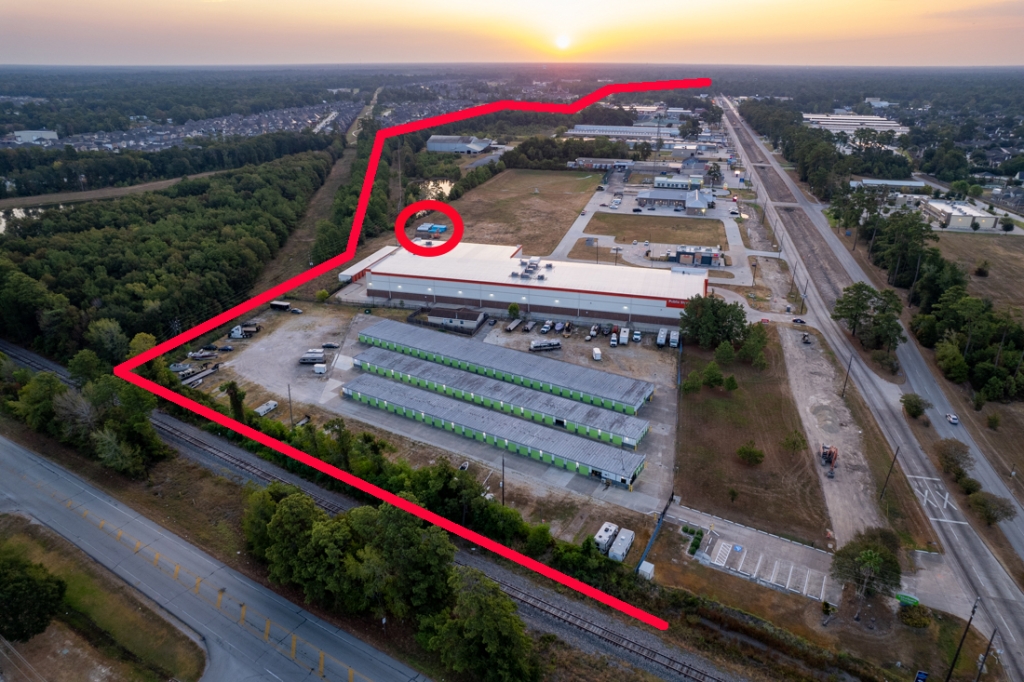
will this get any of the $750 million in CDBG-MIT funds from the GLO?
Looking east at West Fork Flooding over Townsen Blvd. during Harvey

Since then, I have investigated why we flooded (beyond the heavy rainfall) and how to prevent similar catastrophes in the future. The causes include:

  1. Unpredictability of storms
  2. Development in risky places
  3. Construction practices
  4. Sand mining
  5. Political complications
  6. Short memories

Let me explain each briefly.

Unpredictability of Storms

The only way to predict the future is by looking at the past. But the future often surprises us. Unfortunately, we base engineering on yesterday’s storms, not tomorrow’s. Engineering bigger safety margins into our flood control systems is too costly. Especially when you try to do it retroactively.

Development in Risky Places

We build too close to rivers. In swamps. Over wetlands. On fault lines. Why? Simple. Money. There’s always an engineer somewhere willing to render a favorable report about the safety of doing so with certain precautions. But again, they are looking at the past, not the future. And they write lengthy reports that defy comprehension by ordinary homebuyers.

The developers and their trade associations also lobby regulators and politicians to keep requirements loose. Every dubious project falls into that gray area called “acceptable risk.” And it can take years or decades to incorporate known flood risks from storms like Harvey into regulations that govern development. That gives everyone with property in risky places plenty of time to develop it.

Mavera
Clearing for Madera. 2022 photo of development at FM1314 and 242. Parts of development are in 10-year floodplain.

Construction Practices

Why build stormwater detention basins and ditches as big as you should? Why install silt fences? Why plant grass in them to reduce erosion if nobody is inspecting them? All that costs money. But it also sends extra silt downstream. And when the extra water comes on top of it, there’s nowhere for the water to go but into people’s homes.

Eroding ditch in Colony Ridge due to lack of erosion control measures such as backslope interceptor systems and grass.

Sand Mining

To produce marketable sand, mines must wash small particles of clay out of it. Miners then direct the wastewater to settling ponds. But that wastewater builds up. And soon it must be released. Some mines pump it over the sides of dikes. Some just open up their dikes. The result: accelerated deposition of sediment, again blocking rivers and streams.

white water caused by flaunting regulations
Confluence of Spring Creek and West Fork. TCEQ found that Liberty Mines discharged 56 million gallons of white waste water into the West Fork.

The construction of dikes also makes them susceptible to rupture during floods. They are thin, tall, made out of sand, next to rivers, and often unvegetated. Floodwaters can push them in, scoop up silt, and carry it downstream.

Triple PG sand mine draining industrial wastewater into Caney Creek and Lake Houston.

Political Complications

Political leaders deal with dozens of problems a day. A storm like Harvey gets their attention. Six years later, in the middle of a drought, not so much. Flood control spending has dropped precipitously. And what little spending remains has focused on low-to-moderate income areas, not the areas with the most flood damage.

Spending by watershed since 2000
As of end of 2023Q1. Data obtained via FOIA Request.
Based on same data, this shows a totally different rank ordering that ignores impact on communities.

Would it surprise you to learn that halfway through a ten year flood bond, we’ve spent only about 30% of the money? That six years after Harvey, we’re just now seeing the outline of the state’s first flood plan? That sprawling upstream developments pay little attention to sediment control? That many jurisdictions still haven’t adopted minimum drainage regulations?

Short Memories

For the most part, homeowners have restored their property using insurance payments, public assistance, and/or their kids college funds.

Now they want to worry about their kids’ prom dresses, birthday parties, the next vacation and a new car they can’t afford. They just assume that the Flood Bond they approved after Harvey is being spent wisely to protect them. Most don’t even remember what the money was supposed to be spent on.

Photo by Camille Pagel. Her children are helping to gut the kitchen instead of going to school after the Harvey flood.

So it might surprise them to learn that not one capital improvement construction project in the Lake Houston area has yet been approved. It would also surprise them to learn that after spending millions of dollars on studies, their flood risk remains and that the economics of upstream development (see sand mining and construction practices above) continue to increase that risk.

Higher Priorities Replace Flood Mitigation

Now we have crime, election chaos, impeachment spectacles and Trump mug shots to divert our attention. But we will grow weary of these, too. And then the rains will return. People will flood. And we will wonder, “Why didn’t that get fixed?”

Posted by Bob Rehak on August 29, 2023

2191 Days since Hurricane Harvey

The thoughts expressed in this post represent opinions on matters of public concern and safety. They are protected by the First Amendment of the US Constitution and the Anti-SLAPP Statute of the Great State of Texas.

CenterPoint Delays Force Change in Plans on Northpark Drive Expansion

CenterPoint delays have forced a change in Northpark Drive expansion plans.

Contractors working on the Northpark Drive expansion project in Kingwood have installed culvert as far west as they can until CenterPoint begins eliminating 11 conflicts. According to Ralph De Leon, Northpark project manager for the Lake Houston Redevelopment Authority (LHRA), CenterPoint was to have begun eliminating the conflicts on August 1. Four weeks later, CenterPoint hasn’t yet started.

Center Ditch Work Paused; Two New Areas of Focus

The CenterPoint delay is forcing LHRA contractors to change their plans. Specifically:

  • Work in the drainage ditch between east and westbound lanes will pause temporarily.
  • Contractors will move their crews west and begin working on:
    • Expansion of Ditch One that will parallel Northpark to the north.
    • Stormwater retention basins at the corner of Northpark and I-69.

Contractors have already prepositioned equipment and materials for the Ditch One portion of the project behind Duncan Donuts and the stormwater retention basins at I-69. However, as of Sunday morning, 8/27/23, work has not yet begun on either area.

Northpark Drive drainage improvements
Overview showing route of supplementary drainage (Ditch One) from I-69 to to Diversion Ditch and Ben’s Branch.

Photos Taken Sunday August 27, 2023

The pictures below show where contractors will now focus until CenterPoint mobilizes.

Workers have begun pre-positioning equipment and materials behind Duncan Donuts next to Public Storage to begin working on Ditch One.
This image has an empty alt attribute; its file name is 20230827-DJI_0373-copy-1024x682.jpg
Ditch One will carry stormwater north (left) of Northpark from the wet-bottom retention ponds that will be built at I-69.
Looking west along Northpark. Both groves of trees in the foreground will become stormwater retention basins.

Stormwater retention basins will accommodate the extra runoff from the expanded roadway. Culvert under the roadway will connect the two basins and let them drain toward the east into Ditch One.

Looking east at north grove in foreground. Note culvert and pipe being prepositioned inside tree line.

When finished, the twin ponds should resemble the entry ponds at Kingwood Drive.

Where Work Will Pause Temporarily

Meanwhile, farther east, work on replacing the drainage ditch with 5’x7′ culvert has paused.

Looking west along Northpark. Drainage work in the center ditch has paused at JiffyLube until CenterPoint resolves its conflicts.
Looking back east. The 5’x7′ box culverts have already been buried. Eventually two new lanes of traffic will go over them, one in each direction.

LHRA Posts Revised Schedule

LHRA has already posted a revised schedule on its website with a three-week lookahead so that you can plan your schedule to avoid construction.

LHRA has also posted construction drawings; drainage studies; and photos and videos that show the progress of work.

Posted by Bob Rehak on 8/27/23

2189 Days since Hurricane Harvey

Upper Taylor Gully Clean Out by MoCo Precinct 4

Montgomery County has just finished an Upper Taylor Gully clean out that will restore the conveyance in the channel which had become totally blocked.

The new commissioner in Montgomery County Precinct 4, Matt Gray, has adopted a much more active and collaborative role in flood mitigation than his predecessor.

Commissioner Gray’s crews inspected Taylor Gully above the Harris/Montgomery County line and found it totally blocked in places from accumulated erosion and littered with illegally dumped trash.

Gray then dispatched more workers to remove blockages. As a result, residents on both sides of the county line will sleep a little better if and when the next hurricane or tropical storm strikes.

The area they addressed is Woodridge Village, the same area where Harris County Flood Control is working with Sprint Sand and Gravel to double the existing detention basin capacity.

While Harris County Flood Control and the City of Houston own the area around the main ditch, Montgomery County owns the yellow areas (see below).

Montgomery County Taylor Gully Cleanout at Woodridge Village
Pictures below were taken near the blue dot in the center. Montgomery County owns area in yellow. HCFCD and City of Houston own the blue area.

Pictures of Cleanup, Clean Out Effort

Kennedy Williams with Commissioner Gray’s office provided the pictures below. The effort began with inmates removing several truckloads of old illegally dumped tires, trash and signs.

Montgomery County Taylor Gully Cleanout at Woodridge Village
Prisoners removing old tires
Montgomery County Taylor Gully Cleanout at Woodridge Village
Then crews mowed banks of the outfall ditch.
Montgomery County Taylor Gully Cleanout at Woodridge Village
Finally, an excavator and front-end loader removed accumulated sediment
Montgomery County Taylor Gully Cleanout at Woodridge Village
Note how high the dirt line was. Sediment completely blocked the 36-inch outfall pipe.

A Timely, Valuable Job

The Upper Taylor Gully cleanup and clean-out efforts are timely for several reasons. We are:

  • Approaching the peak of hurricane season on September 10th.
  • At the fourth anniversary of the Elm Grove floods that damaged up to 600 homes twice in 2019 – between May 7th and Tropical Storm Imelda.
  • Watching an area of low pressure move into the Gulf that has a 90% chance of turning into a tropical storm or hurricane in the next 48 hours.

While the National Hurricane Center projects that it will miss Houston to the east, the projected impact area has been shifting west in the last 24 hours.

Gray’s effort will help restore conveyance of the Upper Taylor Gully channel to its design specs. It will also help reduce flood risk for hundreds of families should another flood strike the area.

Thank you, Commissioner Gray!

Posted by Bob Rehak on 8/26/2023

2188 Days since Hurricane Harvey and 1437 since Imelda

Heat Records and Water-Use Restrictions

This is a bit off topic for a flood blog, but it affects tens of thousands of readers. Late yesterday, after multiple heat records were broken across the region, the City of Houston announced water-use restrictions going into effect Sunday, August 27, 2023. Let me address the heat first, water restrictions second. Then I’ll discuss rain chances and the tropics.

Heat Records Shattered Across Houston Region

Yesterday, the Houston area experienced another unrelenting afternoon of scorching temperatures. Many areas reached the mid- to upper-100’s with a few areas into the low 110’s.

Afternoon daily temperature records were shattered at many sites – many by several degrees.

Jeff Lindner, Harris County Meteorologist

High Temperatures on Thursday, 8/24/23

BUSH IAH: 109 (tied the all time record high, broke daily record high of 105 from 1980)

Huntsville: 111 (shattered record high of 102 from 2011…daily record high broken by 9 degrees)

College Station: 111 (broke record high of 107 from 2010)

Hobby: 107 (broke record high of 100 from 1980)

Conroe: 108 (broke record high of 105 from 1922…101 year old record)

Brenham: 107 (broke record high of 106 from 1980)

Sugar Land: 107 (broke record high of 101 from 2011)

Wharton: 106 (shattered the record high of 99 from 1911…112 year old record)

Cleveland: 109 (broke record high of 104 from 1980)

Crockett: 109 (broke record high of 106 from 2011)

CoH Water-Use Restrictions

According to a City of Houston press release, Houston has entered Stage Two of the City’s Drought Contingency Plan. Due to intense heat and a significant drop in annual rainfall. Effective August 27, 2023, mandatory water-use restrictions will go into effect. They apply to the entire City:

  • Limit outdoor watering to twice a week between the hours of 7PM and 5AM
  • Sundays and Thursdays for single-family residential customers with even-numbered addresses
  • Saturdays and Wednesdays for single-family residential customers with odd-numbered addresses
  • Tuesdays and Fridays for all other customers
  • Any outdoor water use that results in city water leaving your property (i.e., draining onto adjacent property, or streets or gutters) is unlawful.

Violations of watering times will get you a written warning for the first violation. Any subsequent violations are subject to a fine up to $2,000 for each occurrence; see Section 54.001 of the Texas Local Government Code.

Easy Ways to Conserve Water

Here are some easy ways to conserve water:

  • Check and repair water leaks, including dripping faucets and running toilets.
  • Check sprinkler heads to make sure water is not spraying into the street or directly into a storm drain and/or gutters.
  • Avoid washing sidewalks, patio furniture or cars. If you must wash your car, use a car wash. Most car washes use recycled water.
  • Run dishwashers and clothes washers only when full.
  • Take shorter showers.
  • Install a rain barrel and use it for outdoor watering.
  • Turn off the water when you are not using it (e.g., while brushing teeth or shaving).

For more water-saving tips, visit www.givewaterabreak.org.  

Rain Chances

The high-pressure ridge parked over us for the last two months is giving a little bit of ground. Yesterday, thunderstorms finally overcame subsidence in the super-heated afternoon air mass. The gage at the West Lake Houston Parkway bridge recorded 0.44 inches of rain. Despite several downed trees, people cheered because of our deep drought.

According to Jeff Lindner, Harris County Meteorologist, as high pressure moves west, weak disturbances may approach the area from the east and northeast.

Combined with high temperatures in the low- to mid-100’s, scattered thunderstorms will be possible.

Wildfire Risk Remains

Thunderstorms come with the threat for lightning-induced wildfires. One such fire started yesterday in the Humble area. Lightning strikes will be possible each day and strong gusty winds can quickly fan fires.

Additionally, wind direction and speeds can quickly change near and around thunderstorms creating very hazardous conditions for ground crews. Multiple fires caused by a single thunderstorm can quickly overwhelm local resources. So use extra caution. Burn bans remain in effect.

Western Caribbean Sea

An area of low pressure has crossed Central America into the western Caribbean Sea. It should move north toward Florida. As of this morning, the National Hurricane Center gave it a 70% chance of formation during the next 7 days.

August 25, 2023 8AM update from NHC

However, it remains unclear where exactly any surface low will form and how it may interact with the surrounding landmasses. Additionally, there may be wind shear to contend with in the southeastern Gulf of Mexico. At this time, models predict varying intensity as the storm moves north.

Currently, this system does not pose a threat to Texas. But watch for winds that could enhance our local fire weather.

Posted by Bob Rehak on 8/25/2023 based on information from Jeff Lindner, Harris County Meteorologist, and City of Houston

2187 Days since Hurricane Harvey

Drought Comparison – 2011 to 2023

By Jeff Lindner, Harris County Flood Control District’s Director Hydrologic Operations Division/Meteorologist, with a few minor edits for a non-technical audience.


There have been many comparisons of this summer to that of 2011 with respect to the heat and drought. Below, see the comparison of drought, water supply storage, and heat between 2011 and 2023.

Rainfall (Jan 1 to Aug 23)

 2023 Rainfall2023 Departure2011 Rainfall2011 Departure
BUSH IAH29.97-2.2910.93-21.33
Hobby22.20-11.8310.47-23.56
Conroe28.41-3.2517.54-14.69
College Station21.47-3.7910.57-14.12
As the table above shows, the rainfall departures in 2011 were significantly greater at all sites. That indicates a much more significant drought in 2011 than in 2023.

Rainfall departures in 2023 were tempered by a wet April and May over much of the area, while in 2011 drought conditions in the spring were some of the worst ever recorded with many areas recording their driest spring ever. 2011 was also preceded by dryness in late 2010 that helped to worsen the 2011 drought conditions and water supply concerns. 
 
Rainfall at Hobby Airport in 2011 (Feb-May) was only 1.31 inches compared to 2023 of 11.85 inches.
 
While it is clear that 2011 was worse with respect to lack of rainfall, the abrupt change in rainfall from late spring into the summer of 2023 has “shocked” vegetation across the region.

Additionally, it has been hotter to some degree (especially overnight) in 2023 and the flash drought has been severe with nearly the entire area drought free in early June to all of the area in severe to extreme drought as of August 15th.

The very warm maximum temperatures and record “high” low temperatures over the region have resulted in rapid degradation of vegetation health. Tree losses were staggering in 2011 and the area is starting to see losses mounting in 2023, but far below what was experienced at this point in 2011.

Comparison of Drought Conditions, Extents

In 2011, exceptional drought covered most of the state.

In 2023, exceptional drought is minuscule by comparison.

Reservoir Storage

2011 also featured significant drawdown on area lakes and water supply reservoirs as the longer duration “hydrological” drought resulted in record or near record low inflows to several lakes.

As of this afternoon, statewide reservoir storage is at 69.8% of capacity compared to 65.4% on this date in 2011. A low of 58.5% was recorded on 11-18-2011.

The table below summarizes storage capacities for the first 2 weeks of August 2023 compared to 2011:

 2023 Capacity2023 Departure2011 Capacity2011 Departure
Conroe92.5%-1.6082.0%-4.05
Houston96.4%-.4281.0%-6.50
Livingston89.0%-2.3890.0%-2.08
Texanna77.2%-3.8352.0%-9.62
Somerville79.0%-2.9049.0%-8.06
Travis39.4%-47.9643.0%-44.50
Buchanan49.7%-22.5551.0%-23.00

Lake Conroe and Houston are much better off than in 2011 with Lake Livingston being nearly the same and both Somerville and Texanna significantly better off in 2023 versus 2011. This matches well with the rainfall trends experienced in late Spring over the area which for the most part filled Houston, Conroe, Somerville, and Texanna to near capacity, allowing the recent dryness to be well handled.

This was not the case in 2011 when a very dry spring and dryness from late 2010 was already depleting capacities prior to the summer increased demand and evaporation losses.

Central Texas Lake Levels Lower in 2023

However, across central Texas at Travis and Buchanan, conditions are worse at this point than in 2011.  Travis is 3.46 ft lower in 2023 than in 2011 and Buchanan is 0.45 ft lower.

Central Texas and the highland lakes chain have been in drought conditions since the summer of 2022 and rainfall this spring was not as significant in this area compared to coastal areas of the state and SE TX, so lake inflows have been very low and evaporation and demand maximized.

Heat Comparison

In addition to the drought conditions, it has been brutally hot. But how does 2023 compare to 2011 with respect to 100 degree or hotter afternoons? This is only part of the story of the heat of 2023, as overnight low temperatures have also been warm.  

College Station has recorded 42 days with a morning low at or above 80 degrees,  BUSH IAH 41, and Hobby 44. However, Galveston has recorded 64 days this summer at or above 80 degrees for a morning low.

The above average Gulf of Mexico waters are resulting in exceptional overnight heat along the coast.

Jeff Lindner, Harris County Meteorologist
 Days At or Above 100Days At or Above 105
 2023201120232011
BUSH IAH333432
Hobby281410
Conroe383850
College Station5251229

With the exception of Hobby Airport, 2011 and 2023 are nearly tied for the number of 100 degrees days up to 8-23. Hobby Airport has surpassed 2011 by 14 days.

More significant is the number of days at or above 105 with College Station crushing 2011 by 13 days. All sites have recorded more 105+ degree days in 2023 compared to 2011. The afternoon high temperatures have been higher in 2023 than in 2011 especially at Conroe and College Station.

Most of this has occurred in the last 3-4 weeks as the ground has dried and the influence of high dewpoints from the Gulf has become less. That has let afternoon temperatures spike higher compared to June and July.  

By Jeff Lindner, Director Hydrologic Operations Division/Meteorologist, Harris County Flood Control District, on 8/23/2023

2185 Days since Hurricane Harvey

Northeast Water Purification Plant Expansion Now in Last Phase

The massive $1.77 billion expansion of the 120-acre Northeast Water Purification Plant near Summerwood is now well into its last phase. The last update to the expansion website is dated May 23, 2023 and estimates completion in 2025. Contractors have made considerable progress since May. This satellite image is dated 6/14/23. Note the area on the far right at the eastern side of the plant. That area contains most of the new construction activity.

Landsat Photo in Google Earth from June 2023

Aerial Photos Taken 8/12/23

Compare the photos below of the Northeast Water Purification Plant taken just two months later. They were all taken on 8/12/23.

Looking SW from NE Corner of plant.
Close up looking south.
Wider shot looking N from SE corner of plant. White circle will contain a giant water storage tank.
Looking W at entire plant. Note NE corner of Beltway 8 beyond plant and Atasocita Landfill in upper right.
Looking ENE toward Lake Houston

5X Capacity Increase Will Help Reduce Subsidence

The Northeast Water Purification Plant is designed to help ensure Houston’s water supply while reducing groundwater usage. Pumping groundwater at a rate greater than nature replaces it can cause irreversible subsidence. Subsidence has been linked to increased risk of flooding and structural damage.

The physical site above contains three major sections.

  • The original plant which can treat 80 million gallons per day (foreground)
  • First expansion phase (middle)
  • Second expansion phase (far end).

In May, Phase One was nearing completion and expected to be ready soon. Phase Two is the major focus of efforts now.

Together the first and second expansions will produce 320 million gallons per day, bringing the total treatment capacity to 400 million gallons.

Plant Will Handle Wide Range of Turbidity

Because Lake Houston is so shallow, turbidity increases rapidly during rainfall events. Accordingly, the partners have incorporated both wet- and dry-weather technologies into the treatment plant, so operators can switch nimbly as needed.

Innovative treatment strategies like chlorine dioxide, ozonation and biological filtration have been proven at other Texas facilities using similar source waters. Given the broad range of raw water qualities, they will help the City preserve high-quality finished water and deliver more of it.

Majority of Water Used by Industry

Houston Public Works Drinking Water Operations (DWO) currently serves about 2.2 million people. And Harris County’s population alone is projected to expand to 5.5 million people by 2050. But serving all those extra people is only half the battle.

Industrial and manufacturing operations use a MAJORITY of the City’s water.

Venus Price, P.E., Interim Senior Assistant Director, DWO

Many Sources Help Meet Demand, Protect from Drought

To meet demand DWO has three water treatment plants and 49 groundwater production facilities. They span four counties and 600 square miles, making Houston’s system one of the most complex in the nation.

And to feed those plants, the City of Houston owns a 70% share of Lake Livingston, a 70% share of Lake Conroe, 100% of Lake Houston and a 70% share of the future Allen’s Creek Reservoir on the Brazos River.

Lake Livingston supplies water to Lake Houston and the Northeast Water Purification Plant through the Luce Bayou Inter-Basin Transfer Project.

The variety of sources help sustain a growing population through droughts, such as the one we are in now. Corporations evaluate such factors when choosing where to expand. For more information about Houston’s water supply, check this informative history, written by Susan Smyer in 2008.

Posted by Bob Rehak on 8/22/2023

2184 Days since Hurricane Harvey

Three Named Storms in Atlantic in Two Days, Could Get Fourth

8/21/23 (9 AM CDT) – Three named storms have formed in the Atlantic in two days and we will likely get fourth (in the Gulf of Mexico) today or tomorrow.

Tropical storms Emily and Gert formed in the Atlantic yesterday (8/20/23). Gert formed overnight. And a fourth disturbance barreling across the Gulf of Mexico toward the lower Texas Coast could reach tropical storm intensity today or tomorrow, according to the National Hurricane Center (NHC).

2023 Summary Compared to 30-Year Average

So far this year, the Atlantic Basin has had:

  • An unnamed sub-tropical storm in January, that was later determined to have 70 mph max winds
  • Tropical Storms Arlene, Bret and Cindy in June
  • Hurricane Don in July
  • Emily, Franklin and Gert in August

If the disturbance currently in the Gulf turns into a named storm, it will become Harold – the ninth storm of the year to reach tropical storm intensity.

Normally, by this week in the hurricane season, the Atlantic Basin has five named storms. See the table below from the NHC’s Climatology page.

Progress of the average Atlantic season (1991-2020). 
Date upon which the following number of events
 would normally have occurred.
NumberNamed systemsHurricanesMajor Hurricanes
1Jun 20 Aug 11Sep 1 
2Jul 17 Aug 26Sep 19
3Aug 3 Sep 7 Oct 28
4Aug 15 Sep 16–
5Aug 22 Sep 28–
6Aug 29 Oct 15–
7Sep 3 Nov 15–
8Sep 9 ––
9Sep 16 ––
10Sep 22––
11Oct 2 ––
12Oct 11––
13Oct 25––
14Nov 19––

Greatest Threat to Houston is Fire

None of the current disturbances in the Gulf, Caribbean or Atlantic represent a threat to Houston.

The closest storm to Houston is south of Mississippi as of 9AM Tuesday morning. It will miss the upper Texas Coast and likely come ashore between Corpus Christi and Brownsville tomorrow.

NHC says that showers and thunderstorms are showing signs of organization and banding. Environmental conditions appear conducive for development. And a tropical depression or tropical storm is likely to form before it reaches the coastline on Tuesday. Formation chance is high…80 percent.

The greatest threat to the Houston area is not rain or flooding; north of I-10, we should see only about a tenth of an inch from the storm. But hot, dry conditions combined with a long-term drought have created critical fire weather conditions. A burn ban is in effect. High winds associated with the storm could spread fire quickly. So be careful. Several fires are already burning in other parts of East Texas.

Discussion of Other Disturbances

Unnamed Storm off African Coast

NHC gives the other unnamed storm off the coast of Africa a formation chance of 70% in the next 7 days.

Emily

Emily will also turn north. Its intensity will lessen into a tropical depression by Tuesday morning.

Franklin

NHC predicts Franklin will turn north and cross Puerto Rico, the Dominican Republic and Haiti through the middle of the week. It could produce heavy rainfall; life-threatening flash and urban flooding; and mudslides through Wednesday.

Gert

Gert is quickly unraveling. NHC expects to downgrade it into a tropical depression by Monday at 2PM.

A Record?

Is three or four named storms in two or three days a record? According to Harris County Meteorologist Jeff Lindner, it’s not. The record is closer to five or six at one time, he says. Regardless, tropical activity is heating up. The peak of hurricane season is still three weeks away – September 10th. It looks like earlier predictions of an above-average season were accurate.

In the meantime, watch out for that heat! Here’s a summary put together by Lindner of record highs on 8/20/23.

College Station: 112 (tied all time record high from 9-4-2000, broke the all-time August record high of 110 from 8-17-1903, and shattered the daily record high of 107)

  • BUSH IAH: 108 (broke the daily record high of 107 from 1909). This is only the 5th time since the 1880’s that Houston has reached 108. 1 degree shy of the all-time record high of 109.
  • Hobby: 107 (broke the daily record high of 101 in 1999).
  • Galveston: 97 (tied record high from 1995)
  • Huntsville: 112 (shattered the daily record high of 106 from 1909)
  • Madisonville: 108 (broke daily record high of 105 from 1948)
  • Sugar Land: 107 (broke daily record of 101 from 2018)
  • Conroe: 109 (tied all time record high from 2000 and 1925)
  • Tomball: 110 (shattered daily record of 101 from 1999) All time record high surpassing 108 in 2000
  • Wharton: 106 (broke daily record of 100 from 1911)
  • Brenham: 108 (broke daily record of 105 from 1948)

Posted by Bob Rehak on 8/21/23

2183 Days since Hurricane Harvey

Gulf Disturbance Could Increase Fire Danger

(11AM 8/20/23 and updated at 7PM) Here’s something you don’t often see – a tropical disturbance that could increase fire danger more than flood risk.

The 8am 7-day tropical outlook from the National Hurricane Center shows that Tropical Storm Emily has formed in the Atlantic. Separately, a disturbance lingering over the Bahamas has finally crossed over Florida and moved into the Gulf. However, the latter storm will likely miss Houston as it veers south into the lower Texas Coast and northern Mexico. That means…

8AM update on Aug 20, 2023 from NHC

Twelve hours later, another tropical storm formed in the Atlantic – Franklin. And NHC increased the chances for formation for the two orange disturbances to 70%.

8PM update on Aug 20, 2023 from NHC

High winds from the storm combined with the lack of rain and dry vegetation could actually increase fire danger north of I-10.

Jeff Lindner, Harris County Meteorologist

Rainfall Chances for North Houston Area Slight

Unfortunately, the still unnamed Gulf disturbance will likely bring little rain to the Houston area. The 72-hour cumulative prediction from the National Weather Service shows about a quarter inch of rain south of I-10 and a tenth of an inch north of it.

As of Sunday morning, the disturbance is centered south of the Florida panhandle.

That big clear area over the southern plains and Texas is the high pressure system that has dominated our weather for the last month. It forms a barrier that will likely block the lower pressure system in the Gulf from moving north toward Houston.

High Winds, but Little Chance of Flooding

Jeff Lindner, Harris County meteorologist predicts that tropical moisture will begin to arrive along the Texas coast on Monday with offshore scattered activity increasing through the day.”

Lindner believes that I-10 will be a good dividing line between higher coastal rain chances and lower inland chances late Monday into Tuesday.

Said Lindner, “There will likely be a strong south to north rainfall gradient over the region … with rain chances in the 50-60% range near the coast, 30-40% along I-10, and generally less than 30% north of I-10. 

Lindner expects wind gusts up to 30 knots on Monday and Tuesday as the storm passes. He also predicts that seas will build 5-9 feet for most offshore waters. He also predicts that tides will be elevated late Monday into Tuesday, but he doesn’t expect them to reach critical thresholds or cause any issues along the coast or in the inland bays.

Inland winds will increase Monday into the 15-20 mph range with higher gusts. Ironically, the biggest threat from this storm may be fire.

Lindner predicts that the high winds inland along with low humidity and critically dry vegetation will support an enhanced fire danger for those areas along and north of I-10. “Fires could quickly spread in these conditions,” warns Lindner.

Red Flag Warnings

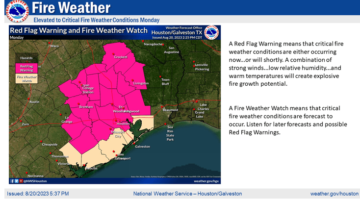
At 2:39 PM, Lindner announced that red flag warnings had been issued for most counties in SE Texas including Harris, Montgomery and Liberty.

Potentially dangerous fire weather conditions will exist on Monday as the tropical system approaches. It will increase the pressure gradient across much of SE TX. Humidity values will decrease through Monday and reach below 30% during the afternoon and early evening hours.

Fuels loads are critically dry over the region, said Lindner. “Small fire will grow rapidly. Fires continue to exhibit aggressive behavior in pine areas and winds on Monday.Ccanopy crown runs will make containment lines challenging.

Fire conditions have deteriorated to those similar to August and September 2011 when several large devastating fires occurred over portions of SE and central Texas.   

Extreme Drought Conditions Persist

In fact, the U.S. Drought Monitor shows that the Lake Houston Area is in Extreme Drought.

What have temperatures and rainfall been compared to the 30-year average?

Temperatures so far this year have been consistently above the average for the last thirty years (green line compared to yellow line). Rainfall (blue and red bars) has been both above and below average. April and May were both above average. But June, July and August have been far below.

According to the Harris County Flood Warning System, the West Fork San Jacinto gage at US59 last received rain on July 23rd – four one-hundredths of an inch!

Obviously, this is not the time for outdoor burning! In fact, the Texas A&M Forest Service shows that most Texas counties currently have burn bans.

Posted by Bob Rehak on 8/20/2023

2182 Days since Hurricane Harvey

Tropics Show More Activity, Higher Probabilities since Yesterday

What a difference a day makes! Yesterday, the Atlantic Basin had four areas of concern. Today, it has five. And, according to the National Hurricane Center (NHC), the chances of tropical development have increased for all of them since yesterday. See the seven-day outlook for the Atlantic Basin below and note the time: Saturday, August 19, 2023 at 3:35 Eastern time.

The NHC diagram below shows a veritable parade of potential storms marching from Africa toward the Americas.

Lowdown on the Lows

Starting with the yellow area moving off the coast of Western Africa:

Yellow Area on Right

A tropical wave located near the western coast of Africa is producing a large area of disorganized showers and thunderstorms. Some slow development is possible while it moves generally west-northwestward across the tropical eastern Atlantic during the next several days. Formation chance through 7 days…still low…20 percent.

Red Area with X

The red cross-hatched area to the left of the yellow is a broad area of low pressure located several hundred miles west of the Cabo Verde Islands. Shower and thunderstorm activity continues. Environmental conditions appear generally favorable for further development. A short-lived tropical depression will likely form this weekend and move west-northwestward at about 10 mph across the eastern tropical Atlantic. By early next week, upper-level winds over the system are forecast to increase, and further development is not expected. Formation chance through 7 days…high…70 percent.

TD #6

Tropical Depression #6 formed in the central, tropical Atlantic this afternoon. The system will move west-northwestward at 10 to 15 mph.  However, upper-level winds will become increasingly unfavorable by late this weekend, so NHC does not anticipate any further development.

Orange Area Entering Caribbean

A broad area of low pressure has formed near the Windward Islands. Shower and thunderstorm activity has become better organized since yesterday. Some additional development of this system is likely and a tropical depression could form by early next week when the system moves into the eastern and central Caribbean Sea. Formation chance through 7 days…medium…60 percent.

Orange Area Entering Gulf

An area of disturbed weather located near the Bahamas will move into the Gulf of Mexico by early next week where a broad area of low pressure will form. Some slow development is possible thereafter. A tropical depression could form as it moves westward and approaches the western Gulf of Mexico coastline by the middle of next week. The storm will likely make landfall in South Texas and bring little rainfall to the Houston area north of I-10. Formation chance through 7 days…medium…50 percent.

Satellite Image Shows Current Conditions in Gulf and Eastern Pacific

The last area represents the most imminent threat to Texas. Here’s what it looks like in a satellite image. Not very impressive at the moment, especially compared to Hurricane Hilary in the Pacific (on the left).

Conditions can change rapidly so prepare and stay aware.

Posted by Bob Rehak on 8/19/23 based on information from the NHC

2181 Days since Hurricane Harvey

Pack Your Patience: Accident Closes Northpark in Both Directions

Update as of 6:30 PM: Outbound lanes have opened. One inbound lane open. Utility crews onsite.

Northpark Drive is closed in the worst possible place at the worst possible time – Friday night during rush hour in a construction zone. However, the accident that caused the closure is not related to construction.

A little before 3 PM, I got a tip about an accident at Russell-Palmer Road from Ralph De Leon, the project manager for the Lake Houston Redevelopment Authority’s Northpark Drive expansion project. He said that a truck had clipped a power pole and wires were down.

By the time I got there with my drone, police and fire trucks had Northpark closed off in both directions between Woodridge Drive and Russell-Palmer. However, I got my drone up from the parking lot of St. Martha’s Catholic Church to get the shots below. That was the easy part.

Getting home (about 2 miles away) took almost 45 minutes.

Bob Rehak

If you have a family member coming into Kingwood during the Friday evening rush hour, warn them to pack their patience. Utility lines are down across the road in BOTH directions.

According to De Leon, Northpark will be closed until the utility company can assess and repair the problem. That could take hours. It will be difficult just to get to the area. Avoid it at all costs.

Photos Taken at 3PM

Looking east along Northpark over Russell-Palmer. Note emergency vehicles blocking inbound traffic.
One utility pole has snapped and another one across Northpark appears to be leaning. However, that could be a shadow.

It’s not clear whether the utility lines carry communications or electricity. The downed line in the photo below is next to a power pole; you can tell by the transformer. So it may be a communications line.

The utility line appears to be caught on an eighteen wheeler blocking the inbound lanes.
The downed lines stretch from the truck to a snapped pole, across the ditch and then across the outbound lanes.

The inbound traffic was being funneled south on Russell-Palmer toward Kingwood Drive. See below.

The utility pole is snapped in half.
Here you can see the lines tangled on the truck. It’s unclear whether the truck struck the pole.
West of Russell-Palmer Traffic is backed up to 59 and maybe beyond.

People trying to enter Kingwood through back streets will find the slogging tough. Everyone who normally uses Northpark is trying to squeeze through stop signs not designed to handle this volume of traffic.

Stay away. If you simply can’t, pack your patience.

Posted by Bob Rehak on 4:30pm on 8/18/23

2180 Days after Hurricane Harvey