This morning, more than 22 months after Hurricane Harvey, the Barrington held a grand re-opening ceremony for its 18,000 square foot Manor House. When project manager Lauren Blackburn cut the red tape, residents got their first glimpse of a newly renovated and re-imagined community facility without equal in Kingwood, and perhaps without equal in the Houston area.
Houston City Council Member Dave Martin (left of bow) addresses a crowd gathered for the ribbon cutting ceremony.Lauren Blackburn, right, the project manager planned the renovation meticulously. She laid out 72 steps that had to be taken before residents could even vote on the proposal.
Time to Enjoy Life Again
Driving into the parking lot, I could sense the electricity in the air. A large crowd gathered in front of the Manor House. People wanted this.
Residents of one of the hardest hit subdivisions during Harvey were out to make a statement. Every home looked perfectly manicured and freshly painted. Every blade of grass looked neatly trimmed and postcard perfect. Golfers were enjoying the immaculate greens and fairways of the surrounding Kingwood Country Club. Even the bluebirds were singing.
Flowers and flags set the stage.Impressive without being intimidating, the Manor House radiates warmth and welcome.Part of the library in the Manor House.Conference table in the library.A grand piano adorns the entry hall which looks out over the swimming pool.Opposite the piano in the entry hall, another conversation area welcomes residents and guests to sit awhile and stay.The Manor House is large enough to provide couples and friends with private, peaceful places to relax and socialize. It’s designed to bring people together..One end of the Manor House provides an exercise room for adults.The kitchen and dining area include a bar.Game room for kids and teens includes a full size pool table.Game room also includes ping pong……air hockey and more. Before the renovation, the Manor House did not have a game room at all.The Manor House even has a play room for smaller children. Parents and babysitters can bring kids here to play and socialize. The Manor House contains a room big enough to host parties, book clubs, church groups and more.Reception area in the Manor House.Pool area behind the Manor House. A lighted tennis court allows extended play for serious enthusiasts.This cabana provides shade near the tennis courts and swimming pool.ResidentsAudrey and Gabriel Alvarado with their daughters Gloria and Reeva, can all walk to the new Manor House.The Barrington is surrounded by the Kingwood Country Club, one of the largest private clubs in the country. It offers 72 holes of golf. The Club’s Lake Course surrounds the Barrington.
Overwhelmingly Approved by Barrington Residents
Blackburn says her team of residents surveyed the community three times to determine what the new Manor House should offer. Residents volunteered ideas for everything from the types of activities to the art on the walls.
Even though renovations cost more than $750,000, a whopping seventy-two percent of the residents voted for them.
Reflecting Needs of Next Generation
The developer originally conceived the Barrington for people older than 55. However, the survey found that 30% of the families had children under 10. As a result, the design of the original building, built in 2002/2003 changed.
“The community is different and the Manor House reflects the composition and wishes of the community,” says Blackburn.
Cultivating a Sense of Community
“In fact, we designed it to cultivate a sense of community,” said Blackburn. “People can hold all kinds of private events here. Or just hang out with friends. Groups can hold private events. Book clubs. Watch parties. Bible study. Birthdays. Community meetings. Weddings. Receptions. No other community has something like this. It’s what makes us special.”
The Barrington offers stately homes on immaculate streets surrounded by the Kingwood Country Club and nature.
Defined by Dreams, Not Disaster
Yes, the people of the Barrington made a statement today. They said, “We will no longer be defined by disaster. We will be defined by our dreams.” And they’re making those dreams come alive.
Posted by Bob Rehak on 7/20/2019
690 Days after Hurricane Harvey
https://i0.wp.com/reduceflooding.com/wp-content/uploads/2019/07/Barrington_14.jpg?fit=1500%2C1000&ssl=110001500adminadmin2019-07-20 22:11:322020-01-17 10:19:46Barrington Is BACK and BETTER!
An old-West saying proclaimed, “Steal my horse; carry off my wife; but don’t touch my water.” Texans fight over water. Even here in the Gulf Coast area. In fact, in Montgomery County, we have a good, old-fashioned water war erupting. Last week in Conroe, it escalated again, putting millions of residents in surrounding counties at risk. Here’s the latest volley in a shot heard across the Gulf Coast.
To someone who hasn’t been following this controversy closely, that resolution sounded innocent enough. Like a little squabble about objectives. But it’s much more.
One side says unlimited pumping has no negative consequences and that restricting the pumping of groundwater violates their constitutional property rights, impinges their freedom, and restricts their ability to grow. They also feel that the forced conversion to surface water is a monopoly conspiracy to run up prices needlessly. They see the other side as over-reaching bureaucrats eager to impose needless and expensive regulation on a population strapped by high water rates (even though Moco surface water rates compare favorably with others throughout the region).
The other side says unlimited pumping will cause subsidence, increase flooding, deplete aquifers, and deny others their fair share of groundwater. They see the other side as selfish water hogs, oblivious to the future, blind to science, and set on an unsustainable course.
Wowsers! How’d we get to this point?
Surface Water Vs. Groundwater: Pros and Cons
Several aquifers lie under the Houston region. Decades ago, people in neighboring counties learned that excessive pumping from these aquifers caused both depletion and subsidence. So they started converting to surface water to limit flood threats and property damage.
However, surface water is inherently more expensive for several reasons:
You have to buy land to create lakes.
You have to build dams and water treatment systems.
You have to build extensive water distribution networks instead of pumping it from under your feet.
All of that creates incentives to continue pumping groundwater.
So groups advocating cheaper water in Montgomery County found two hydrologists who, surprise, surprise, told them subsidence and depletion won’t happen there – even though the area is already subsiding and water well levels have been in decline!
Large amounts of subsidence are already visible in southern Montgomery County where most groundwater pumping takes place.
State Law Requires Neighboring Counties to Approve Pumpage
The state developed Chapter 36 of the Texas Water Code in large part to protect the public interest from private interests. It governs groups such as the Lone Star Groundwater Conservation District in Montgomery County.
Chapter 36 legislates goals for districts. They include:
Conservation
Preservation
Protection
Recharging
Prevention of waste
Control of subsidence
Protection of property rights
Balancing conservation and development of groundwater
Using best available science.
Four Steps to Manage Groundwater
By law and convention, groundwater and subsidence districts manage groundwater with a four-step process.
First, they set goals by defining “desired future conditions.”
Second, they model how much groundwater they can pump to meet those goals.
Third, they develop a plan for achieving the goals.
Fourth, they develop rules for implementing the plan.
It’s enlightening to see how those steps have played out in Montgomery County.
Step One: Define Desired Future Conditions
Groundwater management AREAs (GMAs) set “desired future conditions” (DFCs) or goals for a region. This helps prevent selfish decisions by individual groundwater conservation DISTRICTS (GCDs).
Under current law, goals are now set by a vote of all the GCDs in a GMA.
Instead of your local GCD setting goals for its area, the district must go to the GMA and convince the larger group of GCDs to approve goals for the area. This limits local control, but prevents one district from allowing the aquifer to be mined to the detriment of surrounding counties.
Legislators have divided the Sate into 16 groundwater management areas. Multiple groundwater conservation districts comprise each area (see below).For a high res pdf of this map, click here.GMA 14 includes 20 counties (including Harris and Montgomery), five groundwater conservation districts and two subsidence districts. For a high res PDF of this map, click here.
After the districts in a GMA set the DFC or goal, the Texas Water Development Board (TWDB) sets the Modeled Available Groundwater (MAG). This is the volume of groundwater that can be pumped in a particular area while still meeting the DFC goal.
For example, if Montgomery County wants to maintain stable water levels in the aquifer (at today’s height), then producers can pump approximately 65,000 acre feet per year. Prior to the introduction of surface water in 2015, producers were already pumping in excess of 90,000 acre feet per year.
Step 3: GCD Develops Management Plan
Once TWDB sets the MAG limit, then the GCD is supposed to develop a management plan that includes the approved DFC and MAG. The plan describes how they will achieve the DFC goals.
The TWDB rejected the Lone Star Conservation District’s (LSGCD) plan because it did not include a DFC and MAG approved by the rest of the districts in GMA 14.
The LSGCD board doesn’t like the DFC that was approved by the other GCDs because it would limit pumpage to a sustainable amount. They think mining the aquifer will have NO negative consequences, either to them or to neighboring counties.
They don’t want to be stuck with the 2010 DFC because those DFCs limit pumpage to a sustainable amount. Their problem:
Texas law doesn’t allow TWDB to approve just any DFC that LSGCD wants. All GCDs in the area must approve the goal.
Step 4: GCD Adopts Rules to Meet Goals
Once TWDB approves the management plan, a GCD must adopt rules to achieve its goals. Most often, this means adopting rules that limit pumpage to no more than the MAG (limit).
However, GCDs can structure rules many different ways to accomplish their goal. For instance, they could proportionally limit everyone’s pumpage by the same percentage. Or establish different classes of users with different rules for each, etc.
To confirm the latter, I downloaded and reviewed the 2010 GMA-14 report on desired future conditions from the TWDB website. On pages 30/31, it lists the goals for Montgomery County’s LSGCD. The goals say things like, “From estimated year 2008 conditions, the average draw down of the Chicot aquifer should not exceed approximately 3 feet after 8 years.” They go into similar detail for other aquifers, but using different dates, time spans and depletion rates.
These goals are, in fact, different from the rules that the judge found unenforceable.
Section on Subsidence in Executive Summary
Note the executive summary in the last report. It says:
“Subsidence is a major factor in GMA 14. The GMA 14 consultants spent considerable time and effort to evaluate potential impacts by the DFCs on subsidence. The only means of preventing subsidence is stabilizing groundwater levels throughout the Gulf Coast Aquifer System. The District Representatives concluded that the only means of stabilizing groundwater levels is to limit groundwater production.”
This report was approved unanimously by every subsidence and groundwater conservation district in the management area plus their consultants.
Complaints by other Districts
If you have a hard time following this (and many people will), consider what other experts in GMA-14 say in their letters to the Texas Water Development Board when protesting the action of the LSGCD:
City of Houston Public Works: “Houston is concerned that (LSGCD’s) Management Plan … does not safeguard aquifer recharge and recovery and does not support efforts to address subsidence.”
Montgomery County Water Control and Improvement District #1: Complains about the loss of wells due to water level declines and the expenditure of millions of dollars to drill new wells and reset pumps. Requests TWDB to reject the LSGCD Management Plan.
West Harris County Regional Water Authority: Urges TWDB to reject LSGCD Management Plan because of the impact it will have on groundwater availability and subsidence in northern Harris County.
Woodlands Joint Powers Authority: Requests TWDB to reject LSGCD Management Plan citing pumping of groundwater above sustainable levels, risk of additional water level declines, land subsidence, and flooding that would negatively impact private property rights throughout the region.
Harris-Galveston Subsidence District: The LSGCD management plan… “underrepresents the amount of subsidence that has occurred in Montgomery County. … Any additional withdrawal could cause pressure declines in Northern Harris County and additional subsidence.”
Protect Your Own Interests
Every person and entity who stands to be negatively impacted by LSGCD and Conroe’s actions should make their voices heard. They should notify TWDB that they oppose LSGCD’s appeal and support DFCs that prevent water-level declines and subsidence. They also should notify newspapers, neighbors, and community groups. Subsidence is irreversible. A few years of unlimited pumping can produce water level declines that take hundreds of years to reverse.
So speak up NOW.
Posted by Bob Rehak on 7/20/2019
690 Days since Hurricane Harvey
The thoughts in this post are my opinions on matters of public interest and are protected by the First Amendment of the U.S. Constitution and the Anti-SLAPP statute of the great state of Texas.
https://i0.wp.com/reduceflooding.com/wp-content/uploads/2019/07/GMA14_GCD_map-small.jpg?fit=1500%2C1140&ssl=111401500adminadmin2019-07-20 01:26:332019-07-22 12:09:00MoCo Water War Escalates, Putting Millions in Crossfire
These two images, taken almost two years apart, show one of the most dramatic improvements to West Fork conveyance – the removal of a giant blockage that the Army Corps nicknamed Sand Island.
Sand Island mysteriously appeared during Harvey almost overnight and virtually blocked the entire West Fork of the San Jacinto. Today, the blockage is gone as the before/after photos below show.
Taking Time to Reflect on Accomplishments
This is what Sand Island looked like two weeks after Harvey. It appeared virtually overnight. I took this shot from a helicopter.
Facing east. Sand Island blocks the entire west fork of the San Jacinto. The Kingwood Country Club is in the upper left portion of the photo. Shot from a helicopter on 9/14/2017.
Bayou Land Conservancy Provides the “After” Photo
Suzanne Simpson, Land Stewardship Director for the Bayou Land Conservancy, was doing a wetlands inventory with her drone near River Grove Park this morning. She captured a similar shot below of the same area.
After more than a year of dredging, Sand Island is finally gone. The Army Corps and Great Lakes have restored conveyance on this portion of the San Jacinto West Fork, immediately downstream from River Grove Park.Shot by Suzanne Simpson with a drone on 7/18/2019.
A Job Well Done
This pair of images shows the dramatic improvement in conveyance to this portion of the river. Kudos to the Army Corps and their contractors, especially Great Lakes, which managed this portion of dredging.
Clearing the river of blockages like these should have a dramatic impact on conveyance and help reduce future flooding.
Great Lakes is now working on the mouth bar farther downriver, while Callan Marine is dredging the area near Kings Harbor. Only the mouth bar was/is a bigger blockage on the West Fork than Sand Island.
Additional thanks go to FEMA for funding the project, the Texas Division of Emergency Management, former Congressmen Ted Poe, and the City of Houston.
Since dredging started almost a year ago, the Corps has removed 1.8 million cubic yards of sediment. That’s enough sand to fill the Astrodome.
Posted by Bob Rehak on 7/18/2019
688 Days After Hurricane Harvey
https://i0.wp.com/reduceflooding.com/wp-content/uploads/2019/07/DJI_0033.jpg?fit=1500%2C1000&ssl=110001500adminadmin2019-07-18 21:37:382019-07-18 21:41:01Now You See It; Now You Don’t. Second Biggest Blockage on West Fork GONE!
Harris County Flood Control crews restoring conveyance of Taylor Gully near Harris/Montgomery County line. Video courtesy of Jeff Miller.Woodridge S2 Detention Pond, immediately upstream from Elm Grove on Taylor Gully.Video courtesy of Jeff Miller.
More than 200 homes flooded near Taylor Gully on May 7th that had never flooded before. The ditch winds through Porter, Woodridge Village, Elm Grove and North Kingwood Forest. Homes on all four sides of the new development flooded after contractors altered drainage when clearing the land.
LJA Surveyors Worked over Weekend in Elm Grove
Additional still photos taken last Sunday by Nancy Vera also show LJA Surveying the streets of Elm Grove. Vera asked them what they were doing and the surveyors professed (or feigned) ignorance. They said the reason they were there was “above our pay grade,” according to Vera.
LJA Surveying crew working in Elm Grove on Saturday, July 13, 2019. LJA Surveying is a subsidiary of LJA Engineers, the company hired by the developer of Woodridge Village.Note dumpster in background. Families are still repairing homes more than two months after the May 7th flood. Image courtesy of Nancy Vera.LJA Surveying Truck in Elm Grove. Note: glare caused by shooting photo through windshield. Image courtesy of Nancy Vera.
I’m going to take a wild guess and assume that they’re going to claim that some of the homes were in the 100- and 500-year flood plains. Of course, that ignores the fact that none of those homes had every flooded before, not even in Harvey.
Posted by Bob Rehak on 7/17/2019 with contributions from Jeff Miller and Nancy Vera
687 Days since Hurricane Harvey
https://i0.wp.com/reduceflooding.com/wp-content/uploads/2019/07/IMG_2635.jpg?fit=640%2C480&ssl=1480640adminadmin2019-07-17 21:03:042019-07-17 21:17:27Video shows Taylor Gully Restoration Reaching County Line; Giant Berm Now Separating Elm Grove and Woodridge
Given the amount of sand we’re currently trying to remove from the mouth bar of the West Fork, this post may seem counter-intuitive to many. However…
Worldwide, sand is becoming scarce according to a number of recent reports and articles from respected sources. And as the scarcity transforms economies, it also transforms our environment.
Sand mine complex on the west fork of the San Jacinto adjacent to Kingwood.
Many now question the sustainability of an economy built on sand extraction from rivers and are exploring ways to reduce our dependence on that source … or import sand from places that are still producing it faster than they are using it.
Sand from Greenland?
An article in the New York Times points to people who are actually researching the feasibility of exporting sand produced by Greenland glaciers to Europe where river mining is outlawed in many countries. Such an endeavor would raise the cost of sand.
The article quotes Jason C. Willett, a minerals commodity specialist with the United States Geological Survey. “Currently almost all sand is mined within 50 miles of where it is used,” he said. “Once you move it any distance, it then costs too much.”
Regardless, the world makes so much concrete (more than 10 billion tons a year), that producers are investigating new ways to supply demand. Population is forecast to grow by more than 25 percent by 2050. “That makes sand, which is about 40 percent of concrete by weight, one of the most-used commodities in the world, and one that is becoming harder to come by in some regions,” says the Times.
Sand and gravel make up the most extracted group of materials, even exceeding fossil fuels1.
Urbanization and global population growth are fuelling an explosion in demand, especially in China, India and Africa2.
Roughly 32 billion to 50 billion tonnes are used globally each year, mainly for making concrete, glass and electronics3. (Note: this number is higher than the one quoted above but also includes additional uses.)
This exceeds the pace of natural renewal4 such that by mid-century, demand might outstrip supply2.
Desert sand grains are too smooth to be useful, and most of the angular sand that is suitable for industry comes from rivers (less than 1% of the world’s land)5.
This extraction of sand and gravel has far-reaching impacts on ecology, infrastructure and the livelihoods of the 3 billion people who live along rivers3,6,7
For example, the Nature article says, “In the Mekong delta, the Vietnamese government estimates that nearly 500,000 people will need to be moved away from river banks that are collapsing as a result of sand mining in the channel.”
Likewise, in Bangladesh, the Umngi River expanded when people started mining sand from the river bid.
Another recent report by the United Nations Environment Program (UNEP) says, “Shifting consumption patterns, growing populations, increasing urbanization and infrastructure development have increased demand for sand three-fold over the last two decades,” claims the UN Report. “Further to this, damming and extraction have reduced sediment delivery from rivers to many coastal areas, leading to reduced deposits in river deltas and accelerated beach erosion.”
The report also called for reducing demand for sand and gravel through improved designs that cut the amount of concrete in buildings and infrastructure. (Lighter designs would also help address carbon dioxide emissions: Manufacturing cement, the reactive ingredient in concrete, creatives about 5 percent of global carbon dioxide emissions.
UNEP also warns that, “To meet demand in a world of 10 billion people without harming the environment, effective policy, planning, regulation and management will be needed. Currently, sand extraction and use is defined by its local geography and governance context and does not have the same rules, practices and ethics worldwide.” The report aims to start a productive global conversation on sand extraction.
“To curb irresponsible and illegal extraction, ” the report suggests a customization of existing standards and best practices to national circumstances.”
Like all large scale transformations, this one will not be smooth or simple. The problem with all such reports is that they apply global observations to local conditions. And local conditions always govern actions and economics. As long as it’s cheaper to mine local sand than import it from Greenland, someone will mine it locally.
Those transportation costs can be a killer. In commodity businesses, every penny saved represents a competitive advantage. When you track that penny through the supply chain to the cost of finished goods ( i.e., to a house, a building, or a street, for example), it can have a substantial impact on affordability.
In a highly competitive, free-market economy like ours, producers will always fight to lower their cost of production. Getting them to voluntarily adopt practices that could benefit society is tough.
We can’t even get sand miners to push back 100 feet from the river. 4,000 miles to Greenland is a bit of a stretch!
That tiny problem aside, the value of reports such as these is that they let us develop alternatives before time runs out.
Posted by Bob Rehak on 7/16/2019
686 Days since Hurricane Harvey
https://i0.wp.com/reduceflooding.com/wp-content/uploads/2018/03/Harvey-SanJac_27-e1563290173129.jpg?fit=1500%2C1000&ssl=110001500adminadmin2019-07-16 14:21:152019-07-16 14:21:27Is Time Running Out for Sand?
Beginning last year, developers clear cut the area upstream of the Harris County line without sediment control measures in place. That let erosion from the Woodridge Village property (see below) clog Taylor Gully with sediment.
Photo taken after May 7th flood showed massive erosion over large parts of Woodridge Village. Dirt from this area washed through the culvert in the background which had no erosion control measures in place at the time.
Cleaning that sediment out of Taylor Gully will help restore the natural conveyance of the ditch and reduce future flood risk to Harris County residents.
Video courtesy of Jeff Miller. It looks up Taylor Gully toward the Montgomery County Line in the background and then pans downstream toward Rustling Elms. He was standing with his back to Creek Manor.The culvert you see at the start of this shot is the same culvert in the background of the erosion photo above.
Reducing Flood Risk
Approximately 200 homes adjacent to this ditch flooded on May 7th. Residents appreciate every extra margin of safety they can get, especially since Perry homes and its subsidiaries are far from finished with installing detention upstream.
It was less than a week ago that Harris County commissioners accepted the right of way agreement. That allowed flood control to begin this project. Hats off to to the hard and fast working people at HCFCD!
Posted by Bob Rehak on 7/16/2019 with video from Jeff Miller
686 Days since Hurricane Harvey
All thoughts expressed in this post are my opinions on matters of public policy and safety. They are protected by the first amendment of the US Constitution and the Anti-SLAPP statute of the great State of Texas.
https://i0.wp.com/reduceflooding.com/wp-content/uploads/2019/07/MaintenanceBeginsTaylorGully.jpg?fit=1500%2C840&ssl=18401500adminadmin2019-07-15 22:07:082019-07-15 22:07:14Excavation of Taylor Gully Began Monday
On June 17, the defendants filed a motion to dismiss the suit. The basis of the motion: that Webster and Spurlock had not filed a certificate of merit against LJA Engineers with the initial suit. They claimed that filing such a certificate is a requirement under Texas law when suing engineers.
Motion to Consolidate, Change Venue and Counterclaims
July 8 – Defendants responded to the plaintiff’s motion to dismiss the case(s). They cited the facts that they were NOT suing LJA Engineers, nor were they alleging any defect in their engineering plans or designs. Their claims, they said, related solely to construction practices. Specifically, they cited:
a. Blocking the drainage channels;
b. Filling in existing drainage channels;
c. Failing to properly install box culverts;
d. Failing to create temporary drainage channels;
e. Failing to allow adequate drainage after construction;
f. Failing to install silt barriers;
g. Allowing the Development to force rainfall toward Plaintiffs’ homes;
h. Failing to pay proper attention;
i. Failing to provide notice or warning; the filling in of creeks
j. Failing to have a proper rain event action plan;
k. Failing to have a proper storm water pollution prevention plan;
l. Failing to follow a proper storm water pollution prevention plan;
m. Failing to coordinate activities and/or conduct;
n. Failing to supervise the activities of the Development;
o. Failing to instruct in proper construction and/or drainage requirements;
p. Failing to train in proper construction and/or drainage requirements,
q. Failing to construct the emergency release channel; and,
r. Failing to timely implement the detention ponds.
Judge Reeder has not yet ruled on the change of venue motion or access to the property. Nor has she set a trial date.
Meanwhile, Back at the Construction Site…
Meanwhile, construction on the job site in the last week continued but at a slower pace. According to Elm Grove resident Jeff Miller who has closely monitored construction progress:
Had Hurricane Barry dropped the kind of water here that it did on Louisiana and Mississippi, Elm Grove and North Kingwood Forest residents would almost surely have flooded again.
LJA Engineers designed the onsite detention to hold a little more than a foot of rainfall. But with only an estimated 25% of the detention functioning at this point, 3″ of water could produce another flood (assuming my estimate is accurate).
Posted by Bob Rehak on July 15, 2019
685 Days since Hurricane Harveyand 9 weeks since May 7
All thoughts expressed in this post represent my opinions on matters of public interest and safety. They are protected by the First Amendment of the US Constitution and the Anti-SLAPP Statute of the Great State of Texas
https://i0.wp.com/reduceflooding.com/wp-content/uploads/2019/07/IMG_2575.jpg?fit=640%2C480&ssl=1480640adminadmin2019-07-14 23:23:032019-07-14 23:53:02Update on Webster, Spurlock Elm Grove Lawsuits; Woodridge Construction
According to a report by KHOU 11, Harris County Judge Lina Hidalgo announced on Friday that Kingwood residents affected by floods in early May can now apply for SBA loans. Loan amounts can range up to $200,000 with interest rates as low as 1.983 percent.
Most of those affected live in Elm Grove and North Kingwood Forest. However, the county estimates approximately 400 families in Harris County flooded. They will also be eligible.
Elm Grove on May 9 just south of the clear cut area for the new Perry Homes development in Montgomery County.
Where to Apply
You can get more information about the loans or apply online by clicking here. SBA representatives are also available by calling 1-800-877-8339 or by email at disastercustomerservice@sba.gov.
Harris County, the Texas Division of Emergency Management, the Texas Governor’s Office and the city of Houston worked together to secure the federal assistance.
Hidalgo Stresses Aid May Not Be Available in Next Flood
“We will always fight zealously for our region, but the process for obtaining federal disaster assistance all too often ignores the reality of what’s happening on the ground,” Judge Hidalgo said. “Until the federal government addresses this issue and lowers the threshold for aid, we run the risk in future incidents of hard-hit residents being left without key federal assistance.”
Posted by Bob Rehak on 7/14/2019with help from Juanita Cantu
684 Days after Hurricane Harvey and 9 weeks after the Elm Grove Flood
https://i0.wp.com/reduceflooding.com/wp-content/uploads/2019/07/ElmGroveFlood_01_09.jpg?fit=1500%2C1000&ssl=110001500adminadmin2019-07-14 12:16:092019-07-14 12:26:14KHOU Reports Elm Grove and Other Residents Now Eligible for Low-Interest SBA Loans
Something happened today that made me realize how, as a society, we are losing sight of the things that caused us to regulate the environment 50 years ago. As a result, some bad history could repeat itself
After seeing yesterday’s post about the West Fork mouth bar, a reader named Suzanne Kite sent me a link to an article on BusinessInsider.com. Little did she know that – for me – it would be a free ride on an emotional roller coaster in the wayback machine. The article talked about pollution of America’s rivers before the EPA…and focused on Cleveland, Ohio.
How Physical Landscape Shaped Political Landscape
About two thirds of Americans alive today had not yet been born when Cleveland’s Cuyahoga River caught fire in 1969. So they have no memory of the event that helped give birth to the EPA.
The Cuyahoga River caught fire a total of 13 times dating back to 1868. It was one of the most polluted rivers in America. Photo: Cleveland State University Library.
I remember it vividly. I was born in Cleveland, not far from the Cuyahoga River. Some of my earliest and happiest memories of childhood revolved around clam bakes with my family in Lake Erie in the early 1950s. But then we had to stop. The clams, they said, were contaminated with pollution from the Cuyahoga.
When the Cuyahoga caught fire, it came to symbolize out-of-control pollution. It became the spark that led to the creation of the EPA.
Says Aylin Woodward, author of the BusinessInsider.com article, “The disaster prompted a public outcry that in part led to the formation of the US Environmental Protection Agency (EPA) in 1970. The EPA was charged with regulating the country’s polluted air and waterways…”
“Documerica” Photo Archives
She continued. “Soon after its founding, the agency dispatched 100 photographers to capture the US’ environmental issues as part of a photo project called Documerica. The photographers took about 81,000 images, more than 20,000 of which were archived. At least 15,000 have been digitized by the National Archives, and the images now function as a kind of time capsule…”
The archives actually show many photographs of pollution coming from sand and gravel mines.
Environmental Degradation Preceded Population Loss
Cleveland was a once-proud and booming city that symbolized America’s industrial might. In 1950, it ranked as the seventh largest city in the country. Houston at the time ranked only 14th with a little more than half of Cleveland’s population. In the latest census (2010), however…
An alarming number of readers who saw yesterday’s post about the San Jacinto West Fork mouth bar commented on the massive amount of sediment pollution. They believe that not enough is being done to reduce the amount of sediment coming downstream.
Mouth bar blocking the West Fork of the San Jacinto. Photographed from a drone operated by Franz Willette of BCAeronautics.
Not all, but much of that sediment, in my opinion, came from approximately 20 square miles of sand mines upstream that were inundated by three so-called 500-year storms in 2015, 2016 and 2017. The rate of deposition has increased exponentially as you can see in the graph below.
Sudden exponential growth in mouth bar volume. Graph compiled by RD Kissling from Google Earth historical satellite photos.
FEMA believes that at least 500,000 cubic yards of sediment came downstream during Harvey. The City of Houston believes the number is closer to 1.4 million cubic yards.
All of that sediment pollution threatens the main source of the City’s drinking water by reducing its capacity.
Let’s Learn from History
The point of all this: history is repeating itself.
These developments make me fearful of the future that my children and grandchildren will inherit. If you share these feelings, please continue to apply pressure on elected representatives to push sand mines further back from the river.
What good is cheap concrete if the environment has become so degraded that people move elsewhere?
Posted by Bob Rehak on 7/13/2019
684 Days since Hurricane Harvey
https://i0.wp.com/reduceflooding.com/wp-content/uploads/2019/07/CuyahogaFire.jpg?fit=1500%2C997&ssl=19971500adminadmin2019-07-13 23:01:532019-07-13 23:02:03What Rivers Looked Like Before the EPA Regulated Water Pollution
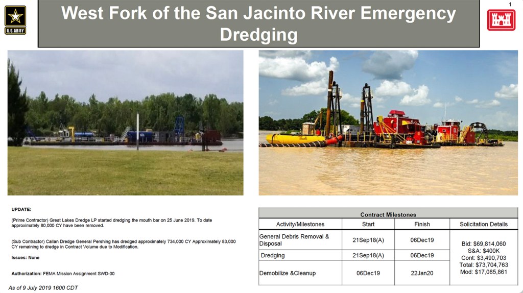
We learned a little bit more this week about the next phase of dredging. Several graphics (below) released by the Corps summarize modifications to the Emergency West Fork Debris Removal Project.
What We Confirmed and Learned
We confirmed that:
Great Lakes, the prime contractor on the original job, will be the only contractor on the Corps portion of the contract extension
Great Lakes will pump sediment all the way upstream to Placement Area 2
The Corps intends to dredge 500,000 cubic yards in the area of the mouth bar.
We learned that:
The original contract contingency allotment of approximately $3.5 million was used up, most likely by additional sediment washed downstream during floods in December, January, February, May and June.
Callan, the subcontractor for phase one, has approximately 83,000 cubic yards to dredge due to modification of the original contract.
Dredging an additional 500,000 cubic yards will cost another $17,085,861
The FEMA/Corps portion of the dredging should finish by December 6, 2019
Demobilization and cleanup will take until Jan. 22, 2020
This is FEMA mission assignment SWD-30
Great Lakes started dredging the mouth bar on June 25th
Great Lakes will dredge a wide area but not go all the way to the FM1960 bridge.
Corps Releases Summary of Project and Extension(s)
I compiled the information above from a PDF developed by The Army Corps. They released it on July 9.
First page of a 2-page PDF released by the Corps on July 9.Second page of a 2-page PDF. Army Corps summary of Emergency West Fork Dredging project. For a high-resolution PDF, click here.
To calculate the depth of dredging in that blue area to the right, I simulated the outline in Google Earth and found that it roughly equals 500,000 square yards. That means if they dredge this whole area, they will reduce the river bed by approximately 3 feet. The area already averages 2-3 feet deep. That means the river will be roughly 6 feet deep through this reach when the Corps finishes its portion of the job.
The area outlined by Corps is approximately 500,000 square yards. Where Callan will finish dredging near Kings Harbor, the depth will be approximately 22.5 feet.
However, upstream, Callan is dredging to a depth of 22.5 feet. Thus, creating a continuous gradient along the river bottom would require dredging approximately another 16 feet deeper in the same area…and that wouldn’t even get you to the FM1960 bridge. Also, note the gap in the graphic between where Callan will finish its portion of Phase One and Great Lakes will start mouth bar dredging.
Unknowns
It is unclear at this point who will dredge the rest of the material that needs to be removed to restore conveyance of the West Fork. Neither the City, County, nor State have yet announced their plans. We don’t know:
Where they will dredge
How deep they will go
Where they will place the material
How much it will all cost, or
When they plan to do it.
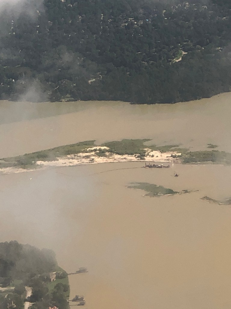
In the meantime, here are two dramatic sequences of photos plus a video submitted by readers this week. They show what the start of mouth bar dredging looked like from the air and water.
Carolyn Daniel Mouth Bar Shots from Airplane Landing at IAH
Carolyn Daniel submitted these shots of the mouth bar and dredging activity taken from her airplane window while on a landing approach to Bush Intercontinental Airport.
On approach to IAH. FM 1960 at bottom of frame. East Fork of San Jacinto upper right and West Fork on the left. Kings Point and Royal Shores between them. Image courtesy of Carolyn Daniel.
Can you spot East End Park? Kingwood Drive? Town Center? All are visible in this shot by Carolyn Daniel.
Mouth bar of west fork with dredge. Photo courtesy of Carolyn Daniel.Note the large Triple-P sand mine near the top of the frame in Porter.
Mouth bar of San Jacinto West Fork with Great Lakes Dredge. Image courtesy of Carolyn Daniel.
Mouth bar of West Fork with dredge. Atascocita Point on left in foreground. Fosters Mill and Kings Point in background.Photo Courtesy of Carolyn Daniel.
Through the clouds. While landing at Bush Intercontinental Airport. Mouth bar of San Jacinto West Fork with Great Lakes Dredge. Image courtesy of Carolyn Daniel.
Franz Willette runs a company called BCAeronautics that uses drones in mapping, inspections, roofing analyses, site surveys, and 3D modeling. He did not have clouds to contend with and could shoot safely from a much lower elevation. Willette is FAA certified.
West Fork Mouth Bar with Great Lakes Dredge. Drone image courtesy of Franz Willette, BCAeronautics.West Fork Mouth Bar with Great Lakes Dredge. Drone image courtesy of Franz Willette, BCAeronautics.Great Lakes should dredge those two small islands in the background.West Fork Mouth Bar with Great Lakes Dredge. Looking south toward the FM1960 Bridge. Drone image courtesy of Franz Willette, BCAeronautics.West Fork Mouth Bar with Great Lakes Dredge. Drone image courtesy of Franz Willette, BCAeronautics.
Kendall Taft Video
Video courtesy of Kendall Taft. Shot from south of mouth bar looking north. Shows how shallow the water is and how vast the expanse is.
I hope to post updates weekly on this project. So readers, please help. Submit your images through the submissions page of this web site. My thanks to Carolyn Daniel, Franz Willette, BCAeronautics and Kendall Taft.
Posted by Bob Rehak on 7/13/2019with help from Carolyn Daniel, Franz Willette, BCAeronautics and Kendall Taft.
683 Days since Hurricane Harvey
https://i0.wp.com/reduceflooding.com/wp-content/uploads/2019/07/BCAeronautics-Mouth-Bar-2.jpg?fit=1500%2C1125&ssl=111251500adminadmin2019-07-12 22:43:452019-07-12 22:47:22Weekly Mouth Bar Dredging Update with Images from Carolyn Daniel, Kendall Taft, Franz Willette of BCAeronautics, and the Army Corps