Today, Harris County Flood Control contractors demolished the townhomes on Aqua Vista Street in Forest Cove. Flooded during Harvey, then abandoned and vandalized, they burned the week before July 4th this year.
Townhomes flooded by Harvey, were burned during the week before the Fourth of July.Today, there’s nothing left. See below.
Only a tiny pile of rubble and some steel girders remain of that block of townhomes this afternoon. They should be gone by the end of the day.The demolition crew was scooping up the last of the structural beams when I photographed the site today.Into a giant truck they went.Tomorrow, there will be nothing left here but faded dreams of happier times.
Update on Remainder of Buyouts
HCFCD has purchased 80% of the townhomes on Aqua Vista St., Marina Drive and Timberline Court. There are 16 units remaining to purchase.
“We’ve demolished three buildings and four more will be demolished by the end of November,” said Matt Zeve, Deputy Director of Harris County Flood Control. “To date, we’ve spent approximately $4.1 million for all costs (appraisal, purchase price, closing cost, relocation, and demolition).”
“A FEMA Hazard Mitigation Grant Program (HMGP) resulting from Hurricane Harvey is partially funding this acquisition. 75% of the cost is from the federal HMGP grant and 25% (plus some relocation costs) is funded by HCFCD. The estimated costs of the townhome buyouts, once complete, will total approximately $5M.” said Zeve.
“HCFCD hopes to complete all acquisition and demolition by the end of 2020,” he said.
Bittersweet Memories
Despite persistent flooding problems, right up until Harvey, many families loved the river lifestyle that these townhomes offered. Since then, they have become an eyesore, a haven for squatters, and a dumping ground. While many former owners and renters will lament the loss of these townhomes, they will also understand the need to move on.
At tonight’s Town Hall meeting at the Kingwood Community Center, the Houston Parks Board will talk about plans for this area. They include a green belt trail to connect the Spring Creek greenway to the Kingwood trail network through Forest Cove.
The Town Hall meeting starts at 6:30 pm.
Posted by Bob Rehak on 10/17/2019 with help from Matt Zeve, Harris County Flood Control
779 Days since Hurricane Harvey and 28 since Imelda
https://i0.wp.com/reduceflooding.com/wp-content/uploads/2019/10/RJR_3749.jpg?fit=1500%2C1000&ssl=110001500adminadmin2019-10-17 17:22:252019-10-17 17:38:49HCFCD Demolishes Flooded, Burned, Vandalized Townhomes on Aqua Vista in Forest Cove Today
The San Jacinto East Fork watershed is immense. Many homes, vehicles, businesses and properties flooded along it during Imelda. Northeast Harris and East Montgomery counties, which contain the East Fork and its tributaries, received some of the heaviest rainfalls during that storm. So how much water came down them? And how did the peaks compare to Harvey?
East Fork Totals Computed by Harris County Flood Control
Jeff Lindner, Harris County Flood Control’s meteorologist computed the peak flows in cubic feet per second for ReduceFlooding.com.
He used the following gages. They are the closest to Kingwood and Huffman :
Peach Creek at FM2090
East Fork at FM1485
Caney Creek at FM2090
The peak flows in cubic feet per second past these gages during Imelda were:
East Fork = 34,600 cfs
Peach Creek = 32,800 cfs
Caney Creek = 9,230 cfs
Total = 76,630 cfs
Numbers Probably Understate True Peaks
The peaks probably exceeded those farther downstream. But we have no way of telling by how much because those are the closest gages to Lake Houston.
Many storm drains and smaller tributaries without gages enter into the flow downstream of those gages. For instance, White Oak Creak, Taylor Gully, Red Gully, Mills Branch, Luce Bayou and more all enter into the East Fork before it reaches Lake Houston. And all of those carry a lot of runoff from developed areas, i.e., areas with a lot of impervious cover, meaning high runoff rates.
Net: Look at the 76,630 cubic feet per second as a minimum.
Comparison of Harvey to Imelda
How did the peaks on these three tributaries compare to Harvey? Consulting the SJRA’s peak flow map from Harvey, we can see that Harvey dumped much more rain:
Caney Creek = 20,00 cfs
Peach Creek = 31,300 cfs
East Fork = 119,000 cfs
Total = 170,000
So Harvey generated peak flows rates twice as high as Imelda. Only Peach Creek had a higher peak during Imelda than Harvey.
Importance of Looking Upstream when Comparing Storms
Remember, when comparing storms, it’s not just how much rain fell on you. It’s how much fell upstream from you. Rainfall patterns can produce dramatically different flooding patterns. During Imelda, while 20 inches of rain were falling on Patton Village, Lake Conroe received only two inches.
Posted by Bob Rehak on 10/17/2019, with thanks to Jeff Lindner and Harris County Flood Control
779 Days since Hurricane Harvey and 28 since Imelda
https://i0.wp.com/reduceflooding.com/wp-content/uploads/2019/10/EF-Tributaries.jpg?fit=1500%2C985&ssl=19851500adminadmin2019-10-17 16:11:362019-10-17 16:11:47How Much Water Came from Where on the East Fork During Imelda ?
Houston City Council Member Dave Martin will host a town hall meeting tomorrow, Thursday, October 17 at 6:30 p.m. It will be at the Kingwood Community Center, 4102 Rustic Woods, Kingwood, TX 77345. Hear from city and community representatives about news related to the Kingwood and Lake Houston areas of District E.
Houston Mayor Sylvester Turner at Kingwood town hall meeting in October of 2018.Flooding was a hot topic then and even hotter now.
List of Speakers and Topics
Texas State Senator Brandon Creighton will kick off the town hall meeting, providing an update on Proposition 8 and sand-mining legislation.
Mayor Sylvester Turner will attend.
Stephen Costello, City of Houston Chief Recovery Officer, will update residents on the progress of projects such as additional Lake Houston Spillway Dam Improvement Project (Flood Gates) and dredging.
Houston Public Works and the Coastal Water Authority will address the Lake Houston Dam Maintenance Project. It’s why the lake will be one foot below normal through next November.
Stan Sarman, TIRZ 10 board chair, will discuss the Northpark Drive Mobility Improvement Project.
Chuck Gilman, San Jacinto River Authority Director of Flood Management, will address the regional watershed study.
Chip Place from the Houston Parks Board will update residents on the Bayou Greenways 2020 project along the San Jacinto River.
Texas Department of Transportation will update residents on the Loop 494 expansion project.
Information About Kingwood Docks and More
Those who arrive early can browse information stations starting at 6:00 p.m. hosted by:
Lovett Commercial (Kingwood Docks)
Houston Public Works
Houston Police Department Kingwood Division
Houston Permitting Center to assist residents with questions related to storm damage repairs and rebuilding.
Tables will remain open after the town hall meeting for those who arrive late.
For more information, please contact Council Member Martin’s office at (832) 393-3008 or via email at districte@houstontx.gov.
Posted by Bob Rehak on October 16, 2019
778 Days since Hurricane Harvey and 27 since Imelda
https://i0.wp.com/reduceflooding.com/wp-content/uploads/2019/03/Turner.jpg?fit=1500%2C1125&ssl=111251500adminadmin2019-10-16 10:47:482019-10-16 10:48:00Town Hall Meeting Thursday at 6:30 Will Cover Wide Variety of Topics
A tropical disturbance located over the extreme SW Gulf of Mexico now has a 50% chance of developing into a tropical cyclone over the next 5 days. At this time there is, still no threat to the Texas coast.
A trough of low pressure that was in Central America yesterday, moved across the Yucatan overnight as predicated. It now is just offshore of the coast of southern Mexico, in the Bay of Campeche and producing disorganized showers and thunderstorms.
Guidance from National Hurricane Center
The National Hurricane Center predicts possible gradual development. They say that a tropical or subtropical cyclone could form late this week over the western or central Gulf of Mexico while the system moves generally northeastward. An Air Force reconnaissance aircraft will investigate the system this afternoon, if necessary.
Formation chance through 48 hours…low…30 percent. Formation chance through 5 days…medium…50 percent.
24 hours ago, the comparable numbers were 0 and 10.
Disturbance in Bay of Campeche now has a 5-day 50% chance of tropical formation.
The Story Behind the Storm
Conditions appear favorable for slow development of this system because of upper level wind patterns and warm sea surface temperatures. An area of high pressure over the SE Gulf of Mexico will direct this feature toward the N and then NNE by late this week.
At the same time an approaching trough from the SW US will move toward west Texas by late in the weekend should force any tropical system to turn NE/ENE. Global model guidance supports a track of any tropical system toward the central or eastern Gulf of Mexico this weekend. Here’s a map that shows the expected location of the front two days from now. Note how the front pushes that orange line toward the NE.
Expected frontal location two days from now should push any tropical disturbance toward the NE.
Given the expected upper level shear across the northern Gulf of Mexico this weekend any system will likely have the majority of the weather near and far to the east of any actual surface circulation. That means people in Louisiana and east of there should get out their umbrellas. Houston will likely be on the dry side of the storm.
Keep your eyes on the Gulf any time a storm forms. Remember that Harvey originated in this same general area and forecasters predicted it to move inland over Mexico. It did…for a while.
Posted by Bob Rehak on 10/16/2019, with help from the National Hurricane Center and Harris County Flood Control
778 Days since Hurricane Harvey and 27 since Imelda
https://i0.wp.com/reduceflooding.com/wp-content/uploads/2019/10/two_atl_5d0-2.png?fit=900%2C665&ssl=1665900adminadmin2019-10-16 10:10:072019-10-16 10:12:32Tropical Formation Chances Increased Again Overnight, But Track Still Likely East of Houston
People who receive individual assistance from FEMA after a disaster such as Harvey are required to have flood insurance. But some people who cannot afford flood insurance become covered under a group flood insurance policy and may not even realize it.
Flooded During Harvey and Again in Imelda
In the last two weeks, I visited numerous people along the East Fork and Caney Creek in less fortunate neighborhoods. They flooded in Harvey and then again during Imelda. For these people, the devastation is especially crushing because they could not afford flood insurance…or so they told me.
Home below Triple PG Sand Mine in Walden Woods between Caney and White Oak Creekswas almost knocked off its foundationduring Imeldaand suffered extensive damage.
Almost all of the people I interviewed have tried to rebuild homes out of pocket as money becomes available. Some do the work themselves to make money stretch further. They are also trying to replace vehicles lost in floods. For these folks, recovering from the second flood in two years is like climbing a financial Mt. Everest.
Group Vs. Individual Flood Insurance Policies
However, Dianne Innes Cooper, who used to work for FEMA, made me aware of their Group Flood Insurance Policies. Then Kaaren Cambio, Congressman Dan Crenshaw’s assistant, made some calls to FEMA to explore who is eligible.
In short, if you flooded during Harvey, received FEMA Individual Assistance (IA), and flooded again, you are most likely covered under a group flood insurance policy. You may be entitled to benefits even if you didn’t know about the policy.
The 36-month Group Flood Insurance Policy (GFIP) begins 60 days after the Presidential Disaster Declaration.
The flood insurance is transferrable to people who may buy the property, but not subsequent renters.
Applicants do NOT receive a copy of the actual policy, just a certificate of coverage.
Applicants do NOT have the ability to decline the GFIP.
People who accept SBA loans are NOT eligible for a FEMA-purchased GFIP certificate.
After the Group policy expires, you need to purchase individual insurance to continue coverage.
Most people who flooded during Harvey and again during Imelda would still be covered under a GFIP issued after Harvey.
For More Information and to Verify Coverage
If it sounds like you might be covered under a group policy, but aren’t sure, you can verify coverage. FEMA lists a hotline for disaster assistance: (800) 621-FEMA (3362).
Congressman Dan Crenshaw’s office can also make inquiries for you. However, before the Congressman can help, you must download and fill out a FEMA Privacy Release Form.
Kaaren Cambio from Congressman Crenshaw’s office will be at the FEMA meeting at the Kingwood Community Center tonight starting at 6:30. You can also call or email her at the Congressman’s office during normal business hours.
Posted by Bob Rehak on 10/15/2019, with thanks to Dianne Cooper and Kaaren Cambio
777 Days after Hurricane Harvey and 26 after Imelda.
https://i0.wp.com/reduceflooding.com/wp-content/uploads/2019/10/RJR_3655.jpg?fit=1500%2C1000&ssl=110001500adminadmin2019-10-15 18:09:302019-10-15 21:23:49You May Have Group Flood Insurance and Not Even Realize It
Updated Tuesday @ 1:25 p.m.: At 1 p.m. Houston time this afternoon, the National Hurricane Center upgraded the chances of tropical formation for a disturbance that could move into the Gulf tomorrow.
As of 7 a.m. Houston time this morning, the National Hurricane Center issued this advice about a trough of low pressure that is producing showers and thunderstorms over the southern Yucatan peninsula, Belize, and northern Guatemala.
“By late Wednesday, the disturbance is forecast to emerge over the Bay of Campeche and gradually turn northward. Environmental conditions could become a little more conducive for some development towards the end of the week when the system is located over the western Gulf of Mexico.”
Formation chances through 48 hours are now rated…low…near 10 percent. Formation chance through 5 days…medium…40 percent.
Advice from Harris County Flood Control
Jeff Lindner, Harris County Flood Control’s meteorologist, had this to say about the disturbance.
Global forecast models have been suggesting that the large area of disturbed weather over central America will drift WNW into the southern Bay of Campeche by the middle of this week and then NW toward the SW Gulf of Mexico by late this week. Recent trends suggest upper level conditions may become favorable for the formation of a tropical system over the SW Gulf of Mexico late this week into this weekend.
Influence of Upper Level Currents
Lindner continued. “An amplifying upper level trough will be approaching TX by late this weekend into early next week and this feature should force any tropical system that forms toward the N and then toward the NE.”
“Latest guidance continues to indicate a tropical system moving across the west-central then north-central Gulf of Mexico this weekend.
It would be extremely rare for a tropical system to impact the state of TX this late in the hurricane season and the upcoming upper air pattern by this weekend favors a turn of any western Gulf of Mexico system toward the NE toward the central or eastern US Gulf coast.”
Local Forecast: Up to 3 Inches Possible
Lindner had this to say about the forecast for the Houston Area. “A cold front will move into the area tonight and this boundary along with pooled high moisture levels will support a good chance of rainfall over the area tonight into early Wednesday. Lines of showers and thunderstorms will be possible along the frontal boundary with rainfall amounts of 1-2 inches and isolated totals up to 3 inches possible. A cooler and drier air mass will move into the region on Wednesday and linger into the later part of the week before moisture begins to return on Friday into the weekend.”
“It is now somewhat uncertain as to how much moisture will move into the area this weekend with the increasing potential for a western Gulf of Mexico tropical system moving across the central Gulf. This feature may take much of the moisture to our east.”
This far in front of a storm, it’s hard to give exact predictions with much confidence. The best advice: raise your alert level and keep your eyes on the Gulf.
Posted by Bob Rehak on 10/15/2019
777 Days after Hurricane Harvey and 26 after Imelda
https://i0.wp.com/reduceflooding.com/wp-content/uploads/2019/10/two_atl_5d0.png?fit=900%2C665&ssl=1665900adminadmin2019-10-15 08:57:502019-10-15 13:32:19This Will Probably Miss Houston, But Keep Eyes on Gulf
Tim Garfield and RD Kissling, two of the world’s top geoscientists, happen to live in the Lake Houston Area. Both spent careers as highly placed executives for one of the world’s largest oil companies. Together, they have led the charge to raise awareness of the growing mouth bar on the West Fork of the San Jacinto where it meets Lake Houston. They have also lobbied long and hard with local leaders and the Army Corps to mobilize an effort to dredge the mouth bar.
On October 2, Garfield gave a presentation to the University of Houston Honors College. Debbie Z. Harwell, PhD, a history instructor at the college and editor of Houston History Magazine, organized the talk. Garfield summarized the history of Lake Houston, the West Fork Mouth Bar and attempts to mobilize a dredging program to remove the bar. The presentation is thoroughly researched and highly interesting. It focuses on the intersection of geologic and human history. Anyone interested in geology, flooding, history or politics should find it informative, fascinating and stimulating.
If you really want to learn what’s happening in the river and why, this is a must read.
The mouth bar is not just a giant sand bar at the mouth of the river. It’s part of an advancing delta system within the river and now the lake. Garfield and Kissling made careers out of studying deltas like this around the world. They point out that the delta’s growth is inevitable and the result of predictable geomorphic processes. All the more reason to take it seriously and plan for regular dredging to keep that channel open.
Yet attempts to remove the threat have largely been unsuccessful and largely for political reasons. The Corps did mount a nominal dredging program in July and August. But it was largely symbolic. They removed about 20-25% of what it would take to extend the upstream dredging channel through the mouth bar.
A post dredging survey shows that the Corps created an underwater box canyon that continues to slow down water and accelerate the deposition of sediment.
In fact, they left far more sediment behind than they dredged. Why? Was there some science to the decision to leave most of it in place? Have they made public a model for peer review that shows this was a good idea? In a word, NO!
Lack of Coherent Dredging Plan
Kissling and Garfield lament the lack of holistic understanding and a coherent dredging plan. I experienced this problem first hand. Before the Corps started dredging the mouth bar area, I requested their plans. The response I got shocked me. “Plans? What do you mean by plans?” That question came on the day of the deadline for processing my Freedom of Information Act request. I replied, “You know…plans…like the ones you shared for the first phase of dredging. Start points. Stop points. Channel widths. Depths. Objectives.” Twenty-three days later, they sent me a CD with 800 pages of uncatalogued information. Not one page dealt with plans. When I complained, they invited me to submit another FOIA request, saying that the first one had been closed out already. I declined their offer.
Clearly, they didn’t have a plan. Except to force the City to assume responsibility for dredging. The Corps and FEMA felt that if the City had done maintenance dredging years ago, the problem would not have become acute.
Since October of last year, the two sides (City and Corps/FEMA) have been playing a political ping pong match, each trying to get the other to dredge.
Post Script: Dredging Update
When contractors finished dredging 500,000 cubic yards from the mouth bar around Labor Day this year, they waited patiently for local authorities to come up with their own plan. Callan Marine got tired of waiting first. Their dredge was last seen weeks ago heading south on 59 in pieces on flatbed trucks.
Great Lakes Dredge and Dock had a dredge anchored at the mouth bar for six weeks. However, today, their dredge and booster pumps have been pulled back to the West Lake Houston Parkway Bridge.
A crane is dismantling the dredge enough to get it under the bridge and back to the command post. Great Lakes is demobilizing. That will leave no dredging equipment in the river.
As of Friday afternoon, according to Stephen Costello, the City filed another request with FEMA. The request was reportedly to allow the City to apply $9 million left over from its debris clean up budget from Harvey to additional debris removal. Unfortunately, going by past experience, remobilizing a dredging effort will cost far more than that.
It will be interesting to see what the City announces at its October Town Hall Meeting at the Kingwood Community Center this Thursday.
Be there. 6:30 PM. On the agenda:
Mayor Turner
Council Member Dave Martin
Stephen Costello, the City’s flood czar, to talk about dredging and dam improvements
SJRA’s Chuck Gilman to talk about status of the regional watershed study
Public Works and Coastal Water Authority to talk about dam repairs and lower lake levels for the next year
Houston Parks Board to talk about an extension of their Bayou Greenways Program south of Hamblen
And more
Posted by Bob Rehak on 10/14/2019, with thanks to Tim Garfield and RD Kissling
776 Days since Hurricane Harvey
https://i0.wp.com/reduceflooding.com/wp-content/uploads/2019/10/River-Gradient.jpg?fit=1500%2C953&ssl=19531500adminadmin2019-10-13 23:27:252019-10-14 11:50:49A Brief History of Lake Houston, the West Fork Mouth Bar and Attempts to Mobilize Dredging of It
This post is for all those unfortunate people who have suffered repetitive flood damage. Learn how you may qualify for federal assistance to elevate your home.
On Tuesday, October 15, at 6:30 p.m., the City of Houston will host a meeting about mitigation grant assistance for repetitive flood-damaged properties at the Kingwood Community Center.
The community center is at 4102 Rustic Woods, Kingwood, TX 77345 on the corner of West Lake Houston Parkway, near the Kingwood Park ‘N Ride.
Many families in Elm Grove who flooded in May also flooded in September and should explore the options in this meeting. Regardless of where you live in the City, if your home has flooded at least twice, you may be eligible to have your home elevated.
Homeowners can speak with the City regarding options. To quality, property owners must:
Hold a National Flood Insurance Program (NFIP) policy.
Reside within Houston city limits.
Have flooded at least twice.
Below is more information.
Information about Tuesday’s meeting
Info About the Program.
Please submit the voluntary interest form available here.
Thanks to Houston City Council Member Dave Martin for setting this up.
Posted by Bob Rehak on 10/13/2019
775 Days since Hurricane Harvey and 24 since Imelda
https://i0.wp.com/reduceflooding.com/wp-content/uploads/2019/05/ElmGroveFlood_13.jpg?fit=1500%2C1000&ssl=110001500adminadmin2019-10-13 18:02:522019-10-13 18:17:40City To Host Meeting Tuesday, 6:30, At Kingwood Community Center for Homeowners Who Suffered Repetitive Flood Damage
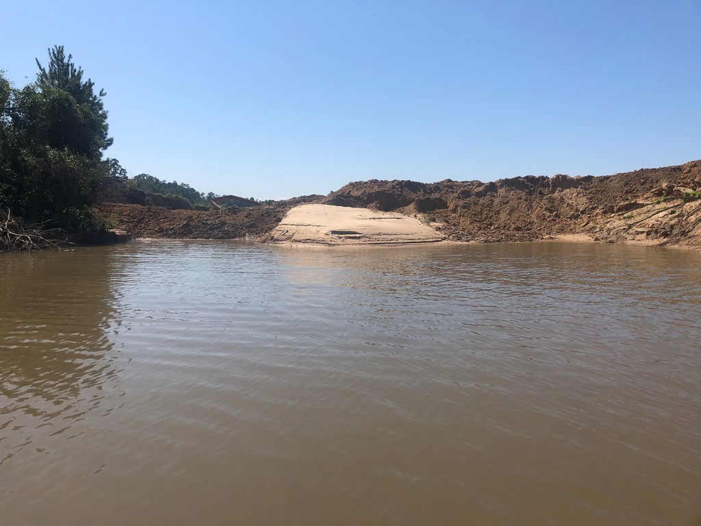
Josh Alberson took the photos below from Caney Creek around 11:30 a.m. on Saturday, October 12, 2019.
While there is now dirt in the breach, it’s not certain what kind. According to Alberson, it appears to be a mix of clay and sand.If this is the same material used in the same way to plug the May breach, it will probably fail the same way in the next flood.
No Serious Attempt to Compact Materials
Alberson says he observed mine employees dumping fill in the breach, but that he saw no attempt to compact the material with rollers. They did tamp it down with the bucket of the track hoe, however. Here’s what it looked like at about 2PM Saturday from Caney Creek. Not very tamped.
Water in the foreground is part of the original May breach. Repairs from May and so far from September, focused on building a road over the breach that acts as a dam. Two hundred feet of woods once separated the mine from the pit.This “dam” or “dike” is now about 15 feet wide and barely above the water at the low point.
Compare Width of Road to Length of Total Breach
The photo below shows the breach in question before repairs. I shot it from a helicopter on 10.2.2019.
Photo of breach looking west into pit before repairs. Note the location of the island and the width of the road relative to the length of the breach between the pit and Caney Creek (bottom left).Then review the satellite image below from Google Earthtaken in February.
Google Earth satellite image before breach in May. Yellow line represents approximate location of breach and measures 218 feet from pit to Caney Creek. Approximate width of repair is 15 feet, 1/14th the width of the original barrier.
Here you can see the width of the road at the end of work today (10/12/2019). Enough to accommodate one way traffic.A reader sent it to me.
Civil Engineer’s Impression of Repairs
Alberson’s brother is a civil engineer. He and another engineer I talked to both felt the repairs were inadequate. When asked what the repairs should consist of, Alberson’s brother suggested:
Temporary dam cut at river and in pit.
Pump out water.
Bring in 100% clay and fill entire dike and previous bank with clay in 1 ft. increments.
Measure clay at its mining point for water content.
After each foot, add spray water, then allow to dry to achieve optimum clay cohesion.
Roll pack with smooth drum roller.
Repeat to needed height.
Add geotextile, large stone, and smaller gravel followed by grass on river and pit side.
Width and height of damn should be determined by vertical drop of pit and horizontal width (i.e., water pressure on dike).
He said if they don’t “roll-pack” it, regardless of whether it is made of clay or not, it will fail.
Impact of “Dike” Failures on Families South of Mine
In the meantime, I interviewed three families below the mine today. They and physical evidence all indicated that water swept through the mine from north to south during Imelda. They said the MINE then flooded them before White Oak or Caney Creek rose. The water from the mine rose so quickly that:
One family narrowly escaped with their horses (unlike Harvey when one died).
Water covered a second family’s SUV in less than one hour. Their house – on 10-foot silts – took on two feet of water.
A third family fled early with their disabled daughter, only to find their home destroyed again when they returned. They also found their foundation undermined by the force of the water from the mine.
There really are no dikes between the mine and these families and dozens of others in their neighborhood. The road surrounding the mine is flush with ground level. It provides no protection when stormwaters capture the pit.
More on their stories in future posts. In the meantime, here are some photos of the heartbreaking devastation they suffered.
The back of Tom and Sherry Gills garage faces the mine. Just feet from the mine’s southern boundary, scouring was so bad that it undermined the foundation. Shelley Portillo’s porch also faces the mine. Water went in one side of her home and exited the opposite side, leaving sand waves in her home.Melissa Stowe’s back yard. Direction of flow came from mine and pushed construction debris up against tree line. Elevating her house ten feet after Harvey wasn’t enough. Twelve feet of water inundated her property.
Posted by Bob Rehak on 10/12/2019 with help from Josh Alberson and Charlie Fahrmeier
774 Days since Hurricane Harvey and 23 since Imelda
The thoughts expressed in this post represent my opinions on matters of public interest and safety. They are protected by the First Amendment of the US Constitution and the Anti-SLAPP Statute of the State of Texas.
https://i0.wp.com/reduceflooding.com/wp-content/uploads/2019/10/Alberson-10.12.19a.jpeg?fit=1500%2C1125&ssl=111251500adminadmin2019-10-12 21:46:082019-10-12 22:16:51Triple PG Mine Scurries to Fill Breaches Day After Attorney General Files Lawsuit
If past performance is any indication of the future, the mine is likely to receive a slap on the wrist. Fines against sand mines from the TCEQ have averaged around $800. However, this is more serious. The attorney general is involved. And stiffer penalties are now available thanks to a new law sponsored by State Representative Dan Huberty in the last legislation session.
If a court levies maximum penalties against this mine, the owners could be liable for $1.1 million plus $25,000 per day for each day breaches in the mine’s dikes remain open. That could easily exceed another half million dollars.
In addition, Ramiro Garcia, head of enforcement for the TCEQ, said the commission disengaged from settlement talks with Triple PG regarding May breaches. Those breaches also took weeks to patch. If lumped in with this, the court could assess yet another half million dollars.
Claim Patches in May Breaches Made with Clay
According to the results of the May investigation, investigators believe the mine patched its breaches with clay. But photos of the failed dikes indicate they were made from sand.
Breach of Triple PG Mine on Caney Creek in September. Photo taken 9/29/19.Close up of same breach reveals that this repair was clearly made from sand.Photo taken on 9/29/2019.Here’s what the same breach looked like from the air.Photo taken on 10/2/2019.I photographed at least 7 additional breaches that same day. Photo courtesy of Josh Alberson, showing that the breach remained open last Saturday, October 5, when he took this shot from his jet boat on Caney Creek.Investigators found the same breach open on the 9th, 20 days after Imelda.
About Chapter 26 of Water Code
Chapter 26 covers water quality control and industrial waste water. It defines “Industrial waste” to mean “…waterborne liquid, gaseous, or solid substances that result from any process of industry, manufacturing, trade, or business.” Its definition of “pollutant” includes “dredged spoils.”
“Pollution” also means “the alteration of the physical, thermal, chemical, or biological quality of, or the contamination of, any water in the state that renders the water harmful, detrimental, or injurious to humans, animal life, vegetation, or property or to public health, safety, or welfare, or impairs the usefulness or the public enjoyment of the water for any lawful or reasonable purpose.”
Triple PG Mine is at the confluence of floodways for White Oak Creek and Caney Creek.
The mine is in the confluence of two floodways: White Oak Creek and Caney Creek. Both are tributaries to Lake Houston, the source of drinking water for millions of people. The purpose of Chapter 26: “to maintain the quality of water in the state consistent with the public health and enjoyment…”
The code considers the possible adverse effect that illegal discharges might have on receiving bodies of water, such as Lake Houston, and on parks, such as East End Park in Kingwood.
Although the Code permits some discharges. However, “Discharges covered by the general permit will not include a discharge of pollutants that will cause significant adverse effects to water quality.”
Chapter 26 stretches more than 200 pages and 58,000 words. So I won’t attempt to summarize it here, except to say that it also includes the disposal of chlorides. One former executive for the City of Houston’s public works department told me that he personally witnessed many sand mines intentionally breaching dikes under the cover of floods to eliminate chloride buildups in their wash water.
“Companies that pollute Texas waterways will be held accountable,” says TCEQ Executive Director Toby Baker. “Every business has a responsibility to respect laws that protect the environment and public health, and I applaud the attorney general for acting swiftly on my request to hold Triple P.G. Sand Development fully responsible.”
The State of Texas requests that the court grant the following relief as allowed by law:
A permanent injunction
Civil penalties and reasonable attorney fees
Court costs
Investigative costs.
Repeated Dike Failures
The dikes of the Triple PG Sand Mine do not appear to comply with TCEQ rules for dike construction. They are built from sand and have failed repeatedly in multiple locations. However, the TCEQ rules clearly state, that structural integrity is the number one concern. “Construction must be based upon sound engineering principles. Structural integrity must withstand any waters which the levee or other improvement is intended to restrain or carry, considering all topographic features, including existing levees.”
The Attorney General’s charges do not mention dike construction. Reading the requirements, however, it will be interesting to see which professional engineer signed off on the plans. The requirements state:
“§301.36. Plans To Bear Seal of Engineer.“
“All preliminary plans and other plans which are submitted with an application for approval of a levee or other improvement shall be prepared by or under the direction of a registered professional engineer and signed by the registered professional engineer whose seal shall appear upon or be affixed thereto.”
Stay tuned. More investigation to follow.
Posted by Bob Rehak on 10/11/2019, with thanks to Dan Huberty, Charlie Fahrmeier and Josh Alberson
773 Days after Hurricane Harvey and 22 after Imelda
All thoughts in this post represent my opinions on matters of public safety and policy. They are protected by the First Amendment of the US Constitution and the Anti-SLAPP Statute of the Great State of Texas.
https://i0.wp.com/reduceflooding.com/wp-content/uploads/2019/10/IMG_0480.jpeg?fit=4032%2C3024&ssl=130244032adminadmin2019-10-11 20:21:042019-10-11 21:37:48Texas Attorney General Files Charges Against Triple PG Sand Mine