Fecal contamination of water can have many health consequences. It can also have consequences for your wallet in terms of hospital bills and water treatment costs. The expansion of Houston’s Northeast Water Purification Plant will cost $1.765 billion.
Persistent Sewage Leaks at Colony Ridge
Yesterday, I reported on 48,000 gallons of sewage documented by the TCEQ in ditches and streams near Colony Ridge in Liberty County just before Imelda struck last year. Stormwater from that area flushes into the San Jacinto East Fork and Lake Houston. Any sewage not cleaned up from that particular spill likely wound up in the main source of the City of Houston’s drinking water.
Had it been a one time affair, it could have been explained as an accident. But the problems recur. Neither the developer, sewage contractor, County, nor State have managed to eliminate the frequent leaks.
Sewage Coverup
In fact, yesterday’s post contained photographs of one incident where the leak remained. A bulldozer had simply covered up sewage that leaked into the ditch adjacent to a road. It was as if the people responsible were saying, “out of sight, out of mind.” The sewage leak remains, though, and without remediation, the pollution will eventually wash down toward Tarkington Bayou, which also enters the East Fork.
Putting Water Test Results in Context
Two recent tests of samples taken within Colony Ridge by Eastex Environmental Labs showed fecal contamination on the order of 3,000 to 5,000 “colonies” per 100 milliliters. Just what does that mean?
One-hundred milliliters equals a little more than six tablespoons.
The presence of fecal contamination is an indicator that a potential health risk exists for individuals exposed to this water. Diseases and illnesses that can be contracted in water with high fecal coliform counts include but are not limited to:
Typhoid fever
Hepatitis
Gastroenteritis
Dysentery,
Ear, nose, eye and cut infections.
Cost to Make Drinking Water Safe
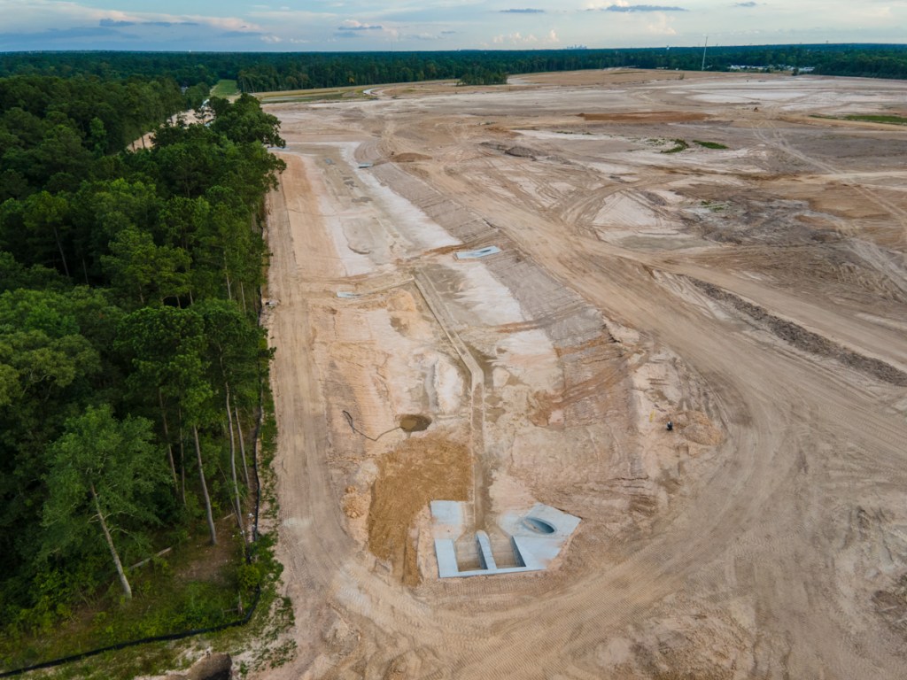
On my last flight over Lake Houston, I flew over the expansion of the Northeast Water Purification Plant. Until you’ve seen this in person, it’s hard to believe how large it is.
The new plant will quintuple the amount of pure, fresh water available to customers in this area. The City is adding 320 million gallons per day (MGD) to the existing 80 MGD capacity for a total of 400 MGD.
In addition to conventional treatment processes, the new plant will include an advanced oxidation process called ozonation. Ozonation helps disinfect water to help ensure that harmful organisms such as Giardia and Cryptosporidium are eliminated. Ozonation also helps eliminate taste and odor causing compounds.
The intake facility shown below will finish next year, but the plant itself won’t finish until mid 2025.
All aerial images below were taken on 6/16/2020. While the plant expansion will make drinking water safe, it won’t make all the water in Lake Houston safe as long as people allow fecal contamination to leak into it.
The expanded plant lies more than a mile from the intake in the foreground.
The expansion will occupy approximately 150 acres of the City’s 252 acre site.
The new intake pump station will be located approximately 900 feet from the shore of Lake Houston to draw water from a deeper depth than the current intake.That, say the partners, will alleviate some water-quality challenges.Construction of the intake pump station should finish in about a year.The pipelines carrying water back to the treatment plant will measure 108″ in diameter.That’s nine feet tall. About the height of that cargo container used as a construction office!Photo cropped and enlarged from wider image above.
The City and its partners have produced an easy-to-understand, yet informative website that documents construction of this project.
This PowerPoint, posted as part of the latest update is packed with photos that may inspire your kids and grandkids to become engineers someday. It shows the meticulous planning and attention to detail that goes into such a project.
Objectives for Project
According to the web site, the project has two objectives:
To support the region’s growth
To reduce subsidence
But the partner’s sell themselves short. The fundamental reason is to provide safe, clean drinking water, despite the pollution from places like Colony Ridge.
For the record, lest you think I’m picking on Colony Ridge, there are many other sources of water pollution. They include livestock, leaky septic tanks, runoff from streets and more.
We can all help by reporting spills and leaks to City, County and State authorities when we see them.
Posted by Bob Rehak on 6/24/2020
1030 Days after Harvey and 279 since Imelda
The thoughts expressed in this post represent opinions on matters of public concern and safety. They are protected by the First Amendment of the US Constitution and the Anti-SLAPP Statute of the Great State of Texas.
https://i0.wp.com/reduceflooding.com/wp-content/uploads/2020/06/20200616-RJR_3337.jpg?fit=1200%2C800&ssl=18001200adminadmin2020-06-24 22:32:002020-06-25 00:03:44Hidden Cost of Fecal Contamination: Removing It
Jeff Lindner, Harris County Meteorologist just issued an alert concerning increasingly heavy rainfall potential for this evening. And the National Weather Service has issued a FLASH FLOOD WATCH for all counties in the Houston region.
Conditions Right for Heavy Rainfall
“Short range model trends are starting to paint a concerning picture for this evening,” said Lindner, “as a slow-moving, low-level boundary moves into the area and helps to focus a west-to-east oriented line of thunderstorms. Recent trends and high-resolution models suggest potential training bands of heavy rainfall this evening into the overnight hours.”
“Given parameters in place including deep tropical moisture, slowing storm motions, and a good feed of low-level flow off the Gulf, excessive rainfall rates of 2-4 inches per hour will be possible and this will lead to rapid street flooding.”
“If storms anchor or slow over an area for a few hours, the rainfall total could quickly reach 4-6 inches with higher isolated amounts,” said Lindner.
All Houston Region Currently in Danger Zone
Lindner feels all areas within the region may feel the effects. “Everywhere should be ready. As of Noon, I suspect the main focus area will be Waller, Austin, NW Harris, SW Montgomery Counties. But we will have to see how things develop this afternoon.”
For the moment the main concern is street flooding.
The front will lift back northward on Thursday and will likely trigger another round of showers and thunderstorms.
NWS Issues Flash Flood Watch
The National Weather Service in League City has issued a * Flash Flood Watch for portions of south central Texas and southeast Texas, including the following areas, in south central Texas, Coastal Jackson and Inland Jackson. In southeast Texas, Austin, Brazos, Burleson, Chambers, Coastal Brazoria, Coastal Galveston, Coastal Harris, Coastal Matagorda, Colorado, Fort Bend, Galveston Island and Bolivar Peninsula, Grimes, Houston, Inland Brazoria, Inland Galveston, Inland Harris, Inland Matagorda, Madison, Matagorda Islands, Montgomery, Northern Liberty, Polk, San Jacinto, Southern Liberty, Trinity, Walker, Waller, Washington and Wharton. *
From 7 PM CDT this evening through Wednesday morning
A line of strong thunderstorms will develop over southeast Texas this evening and slowly move eastward through Wednesday morning. A combination between the slow moving nature of the thunderstorms, back building/training of thunderstorms, and recent rainfall over the area has led to an increasing threat of flash flooding.
NWS predicts rainfall rates may reach one to three inches per hour or more at times.
The NWS also feels uncertainty remains in the timing and location of the line of strong thunderstorms.
On average, two to four inches of rain is expected through tomorrow morning with isolated areas of six to eight inches possible.
These storms with heavy rainfall may be capable of flooding roadways. Low water crossings may flood becoming impassable and dangerous. Small creeks and bayous may see minor rises.
PRECAUTIONARY/PREPAREDNESS ACTIONS
A Flash Flood Watch means that conditions may develop that lead to Flash Flooding. Flash Flooding is a very dangerous situation. You should monitor later forecasts and be prepared to take action should Flash Flood Warnings be issued.
Posted by Bob Rehak on 6/23/2020
1029 Days since Hurricane Harvey and 278 since Imelda
https://i0.wp.com/reduceflooding.com/wp-content/uploads/2020/06/Water-Vapor-Texas.jpg?fit=1220%2C1216&ssl=112161220adminadmin2020-06-23 13:36:002020-06-23 13:36:14Flash Flood Watch: Training Bands of Heavy Storms Could Quickly Drop 4-6 Inches Or More
More recent independent laboratory testing has verified fecal contamination in at least two drainage ditches in Colony Ridge. Moreover, residents claim they have found fecal contamination in other Colony Ridge ditches and streams, too. It’s not clear whether those additional spills have been tested.
During heavy rains, fecal contamination can quickly wash downstream and eventually wind up in Lake Houston.
A major concern of residents is the frequency of sewage leaks.
Results of TCEQ Investigation
Maple Branch Creek carried black water into the East Fork.
TCEQ cited Quadvest L.P., the sewage and water provider for Colony Ridge, for “unauthorized discharge of wastewater which resulted in a documented serious impact to the environment.”
A month after TCEQ documented this discharge, 33 inches of rain fell on nearby Plum Grove during TS Imelda.
Here are results of the first test and pictures of the sewage.
The first site on a ditch next to County Road 5023 showed 3090 and 3130 units of fecal coliform, with none detected in the control sample. Maria Acevedo photographed this problem on June 4, 2020.
Photo on June 4, 2020 by Maria Acevedo on CR 5023 where Eastex took samples.
Sludge oozing down same ditch.
Second Eastex Report Shows VERY STRONG Fecal Contamination
Samples collected and analyzed by Eastex Environmental Labs, eliminating chain of custody issues.
The lab told Acevedo that they found “very strong fecal contamination.”
Maria acevedo
Residents who wish to remain anonymous for fear of retaliation, contacted me about this site a week before Eastex sampled it.
Location of Second Sample Photographed on 6/12/2020
I photographed that ditch on Friday, 6/12/2020. It’s on the southeast corner of Colony Ridge. While there, I photographed cloudy water bubbling up out of the ground and running down a ditch toward Tarkington Bayou (see photos below).
Foul water and trail of greenish-brown sludge (left) bubbling up through ground……then flowed into ditch toward Tarkington Bayou at bottom of hill.Close up of water/sludge in ditch.Silt fence in ditch was propped up, ensuring foul water could ooze under it.Farther down the ditch, contaminated water was pooling, and turning green and black.In places, it had dried due to extreme heat. Temp was in 90’s.
Photos Taken Two Days Later Show Attempted Coverup
I came back two days later on 6/14 to explore the same area some more. The foul water still bubbled up, but someone with a bulldozer attempted to cover up the evidence in the ditch.
Sludge and contaminated water bubbled up from same hole on 6/14/2020.However, the evidence in the ditch near the road had been freshly covered up by a bulldozer.
The Leaks Go On
If the incidents above were isolated, one might dismiss them. But they seem to be part of a larger, recurring pattern that neither Colony Ridge, Quadvest, nor Liberty County have stopped.
A resident says this sanitary sewer was leaking for more than two months into a ditch in a residential neighborhood and stunk like sewage.Photo by Maria Acevedo on CR5006 on March 18, 2020.
The largely Hispanic residents complain among themselves. But few reportedly file reports for fear of raising their profiles with authorities and perhaps answering difficult questions in court. Meanwhile, the sewage leaks go on. Both Colony Ridge residents and those downstream pay the price.
Posted by Bob Rehak on 6/23/2020
1029 Days since Hurricane Harvey and 278 since Imelda
The thoughts expressed in this post represent opinions on matters of public concern and safety. They are protected by the First Amendment of the US Constitution and the Anti-SLAPP Statute of the Great State of Texas.
https://i0.wp.com/reduceflooding.com/wp-content/uploads/2020/06/IMG-7112.jpg?fit=1024%2C576&ssl=15761024adminadmin2020-06-23 00:04:242020-06-23 01:56:3148,000 Gallons of Fecal Contamination Found in Liberty County’s Colony Ridge Ditches, Streams; Problems Persist
Photo Courtesy of Dee Price. Taken at East End Park where Peach Creek, Caney Creek and East Fork all come together.
Stopping Beaver Dams Before They Start
During floods, the downed trees get swept downstream. They form “beaver dams” that back water up when the debris hangs up on other trees, boat docks, bridges and the Lake Houston dam itself. Removing the debris lowers the risk of flooding and damage.
During Harvey, such debris gathered in supports of the Union Pacific Bridge over the west fork, where it contributed to flooding in Humble.
Union Pacific Bridge immediately after Harvey. Photo Courtesy of David Seitzinger.Donna Dewhirst’s boat dock received a 70-foot surprise during Harvey.Rail bridge over Lake Houston after Harvey. Photo courtesy of Donna Dewhirst.Logs collect at Lake Houston Spillway. Photo taken on 6/16/2020.
Improving Boater Safety
The debris pickup also improves boating safety when lake and rivers are low. Submerged trees can injure and kill boaters and water skiers.
Semi-submerged trees in Lake Houston just north of FM1960 Bridge. Photo taken March 6, 2020.
Posted by Bob Rehak on 6/21/2020
1028 Days since Hurricane Harvey
https://i0.wp.com/reduceflooding.com/wp-content/uploads/2020/06/DSCF2256-copy.jpg?fit=1200%2C900&ssl=19001200adminadmin2020-06-21 13:09:402020-06-21 13:09:51New Phase of East Fork Cleanup Begins
Perry Homes’ current contractors have excavated 3X more detention pond volume in ten weeks than the previous contractors did in virtually two years. During this past week, they finished excavating three ponds on the northern section of Woodridge Village. Together, they comprise 77% of the total detention volume for the whole site.
Excavation Done, but Finish Work Remains
That doesn’t mean they’re totally done with the ponds. Recent aerial photos show that they still have much finish work to do. That includes:
Shaping the sides
Creating backslope swales
Installing pipes to funnel water from the swales into the ponds and channels
Ensuring water can flow out of Adams Oaks in Porter on the west side of the subdivision into Taylor Gully as it previously did
Creating concrete “pilot channels” in the center of the ponds and larger channels
Planting grass along the sides of the slopes to reduce erosion
Installing outflow control in several places to hold back floodwaters
Building maintenance roads around the ponds
Elm Grove resident Jeff Miller, who monitors the progress of construction daily, says crews are already hard at work on many of those tasks.
Ponds NOT Expanded Beyond Initial Plans
Miller has compared the width and depth of ponds to the initial plans and verified that the ponds are being built to original specifications. Since the ponds were designed to meet pre-Atlas 14 rainfall requirements, that means the site will still hold 30-40% less runoff than needed to meet current regulations.
With the peak of hurricane season now less than two months away, Perry Homes is in a race against risk. The company may regret the six months of virtual inactivity between the completion of pond S2 and the start of work on ponds N1, N2, and N3 in early April.
The faster pace of current construction puts pressure on Harris County and the City of Houston to complete an offer if an offer will be made. Elm Grove residents lobbied the City and County to purchase the property and build a regional flood detention facility. They center would also help protect downstream residents on the East Fork and Lake Houston.
However, at a Kingwood Town Hall Meeting in February, Mayor Pro Tem Dave Martin announced that the City would not participate in a deal. He said it was the County’s responsibility.
Then in May, the County increased its demands. The County now wants the City to contribute land in lieu of cash to cover half the purchase AND construction costs for creating additional detention.
County and City Clamp Down on Communications
Since then, the County has clamped down on communications regarding this subject. Rumors suggest that all parties are still trying to make a deal happen. But the County has denied all FOIA requests and referred them to the Texas Attorney General for a ruling on their denials. That often happens when negotiations are in progress, according to a knowledgeable source.
What Happens Next?
At the contractor’s current rate of progress, it’s entirely possible that contractors will complete all work on detention ponds in July.
With approximately $14 million dollars invested in the property, with hurricane season here, with lawsuits pending, and knowing that the amount of detention is insufficient to hold a 100-year rain, Kathy Perry must be sweating bombshells.
Ms. Perry may be hoping for a City/County offer, but she can’t be counting on one. If she were, she could have sold the dirt coming out of those detention ponds. Instead, however, she’s building up land elsewhere on the site to keep her options open and develop the site if a deal falls through.
That dirt will have to be moved again at taxpayer expense if the county builds additional detention ponds.
Pictures of Site as of 6/19/2020
Here’s what the site looked like as of 6/19/2020.
Looking NW from over Taylor Gully toward Pond N2, the largest on the property.The connecting channel between N1 at the top of the frame and N2 along the western edge of the property has been excavated.Note the pilot channel that contractors have startedin the distance.At Mace Street in Porter, contractors created a concrete face for the twin culverts on the upstream side, but not yet on the downstream side. Note the earthen dam holding water back while contractors complete the pilot channel running off the bottom of the frame.Above Mace Street, contractors are still putting in pipes between the channel and backslope swales.The Webb street entrance to the site has been removed to connect N1 (out of frame on the top) with N2 (out of frame on the lower left).Looking SE at N1.Looking South at N3, which runs down the eastern edge of the property.More pipes are being put in to channel water from backslope swales to the pond so water won’t erode the face of the pond. Not the rills already cut in the dirt.Looking SE. The southern half of N3 where it connects with Taylor Gully in the upper right.N3’s connection to Taylor Gully is now wide open. It’s not clear how this connection will be completed to release the water at a slow controlled rate.The two culverts under the bridge over Taylor Gully should slow the water from N2 (upper right) and N1 (out of frame) down.
Need for Grass if Deal Not Reached Quickly
Note how the grass on the southern side of the gully has all died. That raises a question. If Perry, the City and County do not complete a purchase agreement soon, will Perry plant grass on the northern section to slow runoff. Right now, it’s all hard-packed dirt.
Most of northern section is hard packed dirt which increases runoff rate.
Planting grass over an area this large would be a big investment and might get in the way of construction if Perry decides to develop the land. But it will reduce flood and legal risks.
Posted by Bob Rehak on 6/20/2020
726 Days after Hurricane Harvey and 275 after Imelda
https://i0.wp.com/reduceflooding.com/wp-content/uploads/2020/06/20200619-DJI_0205.jpg?fit=1200%2C900&ssl=19001200adminadmin2020-06-20 14:57:582020-06-20 14:58:16Perry Contractors Now Focusing on Finish Work for Detention Ponds
Attorneys for owners of 304 flooded homes in Elm Grove have named Perry Homes, LLC and Concourse Development, LLC as additional defendants in their lawsuit. Plaintiff’s lawyers filed their 287-page, sixth amended petition on 6/16/2020. Today, they also filed a request for a new trial date of 3/1/2021.
New Information May Tie Perry, Concourse Directly to Floods
Based on allegations made in the lawsuit, it appears that attorneys may now have evidence that Concourse (the developer of Woodridge Forest) was also part owner of Woodridge Village. Wording within the allegations also suggests that Perry Homes was directly involved in the actions of its subsidiaries PSWA and Figure Four Partners, which in turn were telling contractors what to do and not to do.
This is potentially good news for plaintiffs because companies, such as PSWA and Figure Four are only subsidiaries of Perry. Such subsidiaries often act as shell companies that shield the parent company from liability. With few assets, the subsidiaries simply declare bankruptcy if they lose a large lawsuit. Then, life goes on as normal for the parent company. However…
Both Perry Homes and Concourse Development have substantial assets. Perry claims to be close to a billion dollar company.
Concourse developed the adjacent Woodridge Forest, where Perry also built homes. It bought Woodridge Village land and then held it for six days before selling it to Perry. Evidently, they didn’t sell their entire interest. Before the May 7th flood, Concourse bragged about its role in Woodridge Village. But after the flood, the company removed all mentions of Woodridge from its web site.
Screen Capture from Concourse Development website before lawsuits filed.
Allegations in Sixth Amended Petition
The big news: The plaintiff’s sixth amended petition now names Perry and Concourse as additional defendants. Previous petitions named only Perry subsidiaries, contractors and LJA Engineering.
In the new petition, defendants allege that:
LJA used an outdated version of Montgomery County’s Drainage Criteria manual when it designed drainage for Woodridge Village.
Figure Four failed to properly review the plans, catch the error, oversee LJA, or make construction decisions.
As a group, Figure Four, PSWA, Perry Homes and Concourse (referred to as “Developer Defendants” in the amended petition) hired contractors and directed them to fill in existing creeks and drainage channels, and to remove a levee or berm on the south side of Taylor Gully that had previously protected Elm Grove. The existence of this berm was not mentioned in LJA’s engineering plans, they say.
Even after the first flood on May 7th, when developers were aware of the danger, they failed to take corrective actions that would have prevented the September 19th flood.
As a direct consequence of their actions and inactions, the developers flooded hundreds of homes in Elm Grove.
The inactions of Perry and Concourse following the May 7th flood justify punitive damages.
Key Elements of Agreement Between Developers
The petition also claims that the four developer defendants entered into an agreement that called for them to:
Make exhaustive or continuous on-site inspections to check the quality and quantity of work
Be responsible for the techniques and sequences of construction, and safety precautions
Take responsibility AND liability for the contractors’ failure to construct the project in accordance with the contract documents.
However, the plaintiffs also accuse the developer defendants (through negligence or omissions) of:
Failing to make exhaustive or continuous on-site inspections to check the quality or quantity of the work
Failing to properly monitor the techniques and sequences of construction or the safety precautions to ensure Elm Grove would not flood during construction
Failing to ensure the contractors performed the construction work in accordance with the contract documents
Failing to incorporate drainage studies prior to initiating construction on the Development
Failing to properly direct and supervise the means, methods, and techniques of the sequence in which the contractors performed the work on the Development
Removing drainage from the Development
Removing a levee and/or berm from the Development
Failing to implement a proper construction schedule
Failing to follow the construction schedule
Blocking the drainage channels
Filling in existing drainage channels
Failing to properly install box culverts
Failing to create temporary drainage channels
Failing to allow adequate drainage after construction
Failing to install silt barriers
Allowing the Development to force rainfall toward Plaintiffs’ homes’
Diverting surface water towards Plaintiffs’ homes
Failing to pay proper attention
Failing to provide notice or warning
Failing to have a proper rain event action plan
Failing to have a proper storm water pollution prevention plan
Failing to follow a proper storm water pollution prevention plan
Failing to coordinate activities and/or conduct
Failing to supervise the activities of the Development and engineering
Failing to instruct in proper construction and/or drainage requirements
Failing to train in proper construction and/or drainage requirements
Failure to review engineering plans
Failing to comply with the Terracon Consultants, Inc. geotechnical report
Failing to construct the emergency release channel
Failing to timely implement the detention ponds
Allowing inadequate construction to take place
Failing to hire an adequate engineer to implement the project plan
Failing to protect runoff from flooding homes
Failing to protect Elm Grove from flooding during construction.
Basis for Exemplary Damage Claim
Paragraph 42 contains some of the strongest language in the complaint. It alleges that the Developer Defendants knew of the risks, and both the probability and magnitude of the potential harm to others. The complaint asserts, “These acts and omissions were more than momentary thoughtlessness, inadvertence, or error of judgment. Rather, the Developer Defendants had actual, subjective awareness of the risk involved, but nevertheless proceeded with conscious indifference to the rights, safety, or welfare of others.”
“Such acts and/or omissions,” the paragraph continues, “were a proximate cause of the flooding and the resulting injuries and damages sustained by Plaintiffs. Accordingly, Plaintiffs hereby seek an award of exemplary damages.”
Having said all that, the plaintiffs seek BOTH ordinary and exemplary damages (defined below).
Location of plaintiffs’ flooded homes in relation to Perry/Concourse property.
8 Defendants, 9 Counts, 2 Floods, 3 Degrees of Negligence
Altogether, the petition alleges nine counts against eight defendants in two floods. Spelling out who is being sued for what and why involves a lot of overlap and redundancy. But some of the Counts specify subsets of defendants, floods, allegations and degrees of negligence. So you may want to read the entire document.
The petition splits the defendants into three groups: Contractors, Developers, and LJA Engineering, with specific charges against each. The basis for charges sometimes varies also. For instance, charges against LJA include (in addition to many of those above) failure to:
Adequately report the modeling
Use the correct hydrology method
Adequately model the development
Notify the developers and contractors of the importance of the existing berm.
Plaintiffs say LJA was aware of the risks, but nevertheless proceeded with willful and conscious indifference to the rights safety and welfare of the victims.
As a result, plaintiffs are suing LJA for negligence, negligence per se and gross negligence for BOTH floods.
Differences Between Degrees of Negligence
Black’s Law Dictionary describes the differences:
Negligence is the failure to do something which a reasonable and prudent man would do, or doing something which a reasonable and prudent man would not do.
Negligence Per Se is the form of negligence that results from violation of a statute. The violation of a public duty enjoined by law for the protection of people and property. So palpably opposed to the dictates of common prudence that no careful person would be guilty of it.
Gross Negligence is the intentional failure to perform a manifest duty in reckless disregard of the consequences as affecting the life or property of another. It is a conscious and voluntary act of omission which is likely to result in grave injury when in the face of clear and present danger of which the defendant is aware.
Nuisance Claim
In addition to negligence, plaintiffs also claim nuisance…”When Defendants unlawfully diverted … water onto Plaintiffs’ homes.”
Black’s Law Dictionary defines nuisance as “…that activity which arises from unreasonable, unwarranted or unlawful use by a person of his own property, working obstruction or injury to right of another…and producing such material annoyance, inconvenience and discomfort that law will presume resulting damage.”
Seeking Damages, Exemplary/Punitive Damages
The ordinary damages, plaintiffs claim, consist of one or more of the following:
Cost of repairs to real property;
Cost of replacement or fair market value of personal property lost, damaged, or destroyed during such event;
Loss of use of real and personal property;
Diminution of market value of Plaintiffs’ properties;
Loss of income and business income;
Consequential costs incurred, inclusive of but not limited to alternative living conditions or accommodations and replacement costs;
Mental anguish and/or emotional distress;
Prejudgment interest;
Post judgment interest;
Attorneys’ fees
Costs of Court.
However, as a result of alleged gross negligence, plaintiffs also seek exemplary damages as punishment. Black’s Law Dictionary defines exemplary damages as “Damages on an increased scale awarded to a plaintiff over and above actual or ordinary damages, where wrong done to a plaintiff was aggravated by circumstances of violence, oppression, malice, fraud, or wanton and wicked conduct.”
Defendants’ Responses Not Yet Filed
As of this writing, the Harris County District Clerk’s website does not show responses filed by either Perry or Concourse to new allegations.
March 1 Preferential Trial Date Requested
Because of the number of plaintiffs, expert witnesses, defendants and law firms involved in this case, the plaintiffs have requested a “preferential trial setting” of March 1, 2021. A preferential trial setting eliminates the possibility of numerous continuances due to scheduling conflicts between the court, parties, attorneys and witnesses.
The plaintiffs have also requested a proposed Amended Docket Control Order that shows alternative dispute resolution (mediation) happening on 1/29/2021.
Net: If the judge accepts the new timetable, it will likely be another 7 to 8 months before this case sees any resolution.
As new developments happen, read about them here.
Posted by Bob Rehak on 6/19/2020
1025 Days since Hurricane Harveyand 274 since Imelda
https://i0.wp.com/reduceflooding.com/wp-content/uploads/2020/06/Location-of-Plaintiffs.jpg?fit=1200%2C871&ssl=18711200adminadmin2020-06-19 17:30:442020-06-19 17:33:39Elm Grove Lawsuit Names Perry, Concourse Development As New Defendants; Trial Delayed
Certainly, there are many honorable developers who try to build high-quality communities for people without adversely affecting downstream residents. I don’t wish to malign a whole profession. Nor do I want to fail to acknowledge the many wonderful communities they have built in this area.
But there are also some developers who put profit before people. They try to cut corners wherever they can and hope that nobody will notice. Especially regarding flood control. It’s expensive and easy because most people don’t understand it.
Grand Parkway Coming Soon To Wetlands Near You
The construction of State Highway 99, aka the Grand Parkway, has opened up vast new areas on the outskirts of Houston to developers. Many of those areas consist of wetlands and forests.
TxDoT is currently prepping land for Section H of the Grand Parkway almost all the way to FM 1960 on the east from US59.
From USGS. Wetlands near the path of Grand Parkway extension. Compare with maps above and below.
Visible Difference in Development Density Where SH99 Completed
The map below shows permit applications in the north Houston area. Compare the density of projects around sections of the Grand Parkway that have already been completed (left) with the areas on the east where the concrete has not yet reached.
This map shows permit applications in the northeast Houston area, both within the City and its ETJ (extra territorial jurisdiction. The Colony Ridge development featured below is outside the ETJ (green area) in the upper right of the map above.
Developers have even more projects underway outside the City’s ETJ (not shown on the map above).
How Development Can Affect Flooding
Kingwood residents have seen how one developer can contribute to flooding hundreds of homes. Last year, Perry Homes clearcut 268 acres north of Elm Grove before installing detention ponds. Hundreds of Elm Grove homes then flooded on May 7 and again on September 19, during Tropical Storm Imelda.
Below are recent photos of a massive 10,000 acre development in Liberty County near Plum Grove. It is about to become a 15,000 development now, thanks in part to Grand Parkway access. And yet it has only one small traditional detention pond.
Detention ponds slow down the rate of runoff to compensate for the loss of trees, wetlands and ground cover that have been replaced by streets and rooftops.
Their goal: to prevent downstream flooding.
Colony Ridge Accounts for All Growth in Liberty County In Last Decade
Colony Ridge can account for all the growth in Liberty County in the last decade. Below are some photos of Colony Ridge and its expansion near Plum Grove. The approach of SH99 will make it more accessible and therefore more attractive (at least from one point of view).
All aerial photos below were taken on 6/126/2020.
Looking north across the Grand Parkway extension toward Colony Ridge in Liberty County near Plum Grove.Just north of the Grand Parkway (upper left), you can see roads going in that will accommodate even more manufactured homes, aka trailer homes.The developer puts in roads, ditches, water and sewer. Fire hydrants? Forget it.
Developer’s Marketing Strategy
The developer tries to pass as many costs along to lot buyers as he can to maximize profit. He targets Hispanics. Residents tell me that sometimes two or three families may live in one of the homes you see here.
Nobody knows the real population of Colony Ridge because many residents are reportedly undocumented and uncounted.
Site work before parking a home is the responsibility of site buyers, many of whom openly burn brush to clear their lots. Like the developer, they’re trying to cut costs.
Land of Fire and the Forgotten
Resident burning brush on his property last Sunday afternoon.Residents aren’t the only ones burning.That smoke you see on the horizon is from dozens of brush fires set by the developer as he continues to clear land.Here’s one still smoldering.At this point, a major storm would bring the potential for uncontrolled erosion,just as it did in Woodridge Village in Montgomery County, above Elm Grove.As dry as it has been lately, the developer is burning brush piles next to woodlands. That increases fire risk. The barren surface also accelerates runoff and erosion, increasing flood risk.Note the haze and plums of smoke on the horizonand the vast expanse of exposed, packed dirt.The smoke is coming from burning piles of brush, such as these. If a fire spread into surrounding woods, local volunteer fire departments would be overwhelmed.No fire hydrants anywhere in sight.
If this were Houston, hydrants would be spaced at a minimum of every 500 feet. A firefighter told me that the spacing often depends of home values and population. Based on population alone, he believes this area should have hydrants.
One Small Detention Pond for 15,000 Acres
The developer has one detention pond (center) for the entire 15,000 acres. He relies on less efficient, in-ditch detention for additional capacity.Note the proximity to SH99 in the upper right.There are no detention ponds anywhere in the new areas being cleared. This is reminiscent of Woodridge Village which contributed to the flooding of hundreds of homes in Elm Grove.But Woodridge was only 268 acres. The developer relies on this and other drainage ditches to double as detention ponds in storms. But at the far end of this ditch……FM 1010 washed out during Harvey and destroyed one of the two major access roads into the development. The in-ditch detention failed. So has the county. The road has been out now for 1025 days, increasing the commute time for residents and the response time for firefighters.
Endless Loop of Construction and Destruction
State Highway 99 represents more than just a third loop around the City of Houston.
SH 99 will bring more developersand more people eager to escape downstream flooding issues.
Tapayer funded roads such as these create endless loops of construction and destruction. They are like a perpetual motion machine. Building one area floods another, causing people to move farther out and the cycle to repeat itself.
No one will admit it’s intentional, of course. The flooding is just a byproduct of greed. Cut a detention pond here. Substitute in-line detention there. Don’t bother planting grass to reduce erosion. Send your problems downstream. Let someone else worry about them.
One Chance
Do all developers think that way? Of course not. Many have principles and wonderful communities to show for them.
That notwithstanding, as one Splendora resident said, “They really only have one chance to get this right. If they screw this up, it will be almost impossible to fix and they will argue over who is going to pay for it for centuries.”
We are at that inflection point now.
Posted by Bob Rehak on 6/19/2020
1025 Days since Hurricane Harvey
The thoughts expressed in this post represent opinions on matters of public concern and safety. They are protected by the First Amendment of the US Constitution and the Anti-SLAPP Statute of the Great State of Texas.
https://i0.wp.com/reduceflooding.com/wp-content/uploads/2020/06/20200616-RJR_3705.jpg?fit=1200%2C800&ssl=18001200adminadmin2020-06-18 21:28:292020-06-18 21:57:39“The Developers Are Coming! The Developers Are Coming!”
Construction of State Highway 99, also known as the Grand Parkway, has turned south. It is now approximately 4.5 miles from FM1960, but more than 20 miles from reaching its goal of I-10. In the image below, taken on 6/16/2020, you can see it crossing the Luce Bayou Inter-Basin Transfer project and then heading through open farm land.
Looking southeast. Grand Parkway construction has now passed the Luce Bayou Inter-Basin Transfer Project. Approximately 4.5 miles remains before construction reaches FM1960 to the south.
The Grand Parkway will open up vast areas in Montgomery, Harris and Liberty counties for development. All of that will put pressure on Lake Houston, shown in the lower left of the satellite image below (which was taken seven months ago.
Now, more than ever, it’s important for these counties to work together to reduce the risk of flooding for downstream residents in Houston, which is the economic center of the region.
Without a vital, safe center, growth in the entire region could falter.
Posted by Bob Rehak on 6/18/2020
1024 Days after Hurricane Harvey
https://i0.wp.com/reduceflooding.com/wp-content/uploads/2020/06/20200616-RJR_3555.jpg?fit=1200%2C800&ssl=18001200adminadmin2020-06-18 15:33:432020-06-18 15:33:53Grand Parkway Construction Now Within 4.5 Miles of FM1960
New Caney ISD is planning to build a new comprehensive high school on a roughly 50-acre site between US59 and Sorters-McClellan Road, where a par-3 golf course used to be. The land is south of HCA Kingwood Medical Center and behind several car dealerships that face US59.
New Caney ISD High School #3, still unnamed, will be built where the par 3 golf course used to be in the center of the image above.
Photos of Site and Layout
The site for this high school is roughly 5-acres larger than Kingwood High School’s site. Clearing and grading of the land has already started. See pictures below.
Looking NE. Land for Future New Caney ISD High School #3Looking East. Looking South. Detention pond will go at the far end of this part of the site.
Importance of Detention Pond
A Bid Bulletin described the total project as a 337,000 square-foot, 3-story building with tilt-wall construction and a detention pond.
A building that large, with parking lots, and rubber grass on its playing fields would make make detention ponds critical.
Site Plan for New Caney HS #3 shows detention pond on south side of property (right) and taking up approximately 10% of the property.For a higher resolution PDF, click here.
Plans show that the retention pond will be located along the southern border of the property. The land naturally slopes to there.
Although width and length are not noted on this drawing, it appears to take up about ten percent of the site and have a depth of 6.66 feet. If those are accurate assumptions, that would mean the pond provides 33.3 acre feet of detention for a 50 acre site.
That equals .666 acre feet of detention per acre. The City of Houston requires .5 feet per acre for sites of this size.
But a white paper by the Greater Houston Flood Mitigation Consortium points out that many factors can influence the amount of detention needed to offset development. Those factors include the amount of impervious cover, the soil type and more. They can change the rate needed for protection of downstream residents more than 10X. There is not one-size-fits-all.
Until we learn more about the specifics of this site and project, we can’t know whether this plan provides enough detention. But this certainly is an encouraging start.
Community Impact newspaper reported earlier this year that the high school will open in August, 2022. The project will be built in two phases.
Artists renderings of the campus show a sleek, modern, open, light-filled design.
Aerial image shows high school will be built around an open courtyard giving more classrooms access to more sunlight.Rendering from New Caney ISD.
Artists rendering of lobby of New Caney HS #3 from New Caney ISD.
Front Elevation of the new high school from New Caney ISD.
For those new to the area, two independent school districts serve the Kingwood area. The Humble ISD serves the vast majority of the area. The New Caney ISD serves the parts outside of Harris County on the north and west.
Posted by Bob Rehak on 6/17/2020
1023 Days after Hurricane Harvey
https://i0.wp.com/reduceflooding.com/wp-content/uploads/2020/06/Screen-Shot-2020-06-17-at-4.02.13-PM.jpg?fit=1200%2C946&ssl=19461200adminadmin2020-06-17 18:04:412020-06-17 18:04:53Development Watchlist: New Caney ISD Prepping Land for High School #3 in Kingwood
Harvey inundated many old oil and gas properties in Humble and Kingwood, including many old stripper wells and storage tanks. Nowhere is the problem more apparent than in the abandoned well site next to the Forest Cove little league fields.
Proximity of Abandoned Site and Little League Fields
Harvey floodwaters toppled and rusted tanks which are now leaking onto the soil around them. The wells and equipment have been abandoned. All within range of a long fly ball.
Noxxe Oil & Gas, LLC used to list the abandoned property as its headquarters in Forest Cove until Harvey.Photo taken from helicopter on 6/16/2020, 1022 days after Harvey.
A home run and you’re out! Ain’t no one going over that fence for the long ball.
Closer shot shows three wells, 16 tanks, a truck and a trailer on the site.Sign at entrance to property indicates the Railroad Commission has seized the property and equipment. The TRCC will plug the wells and auction the equipment.This will be a major cleanup. It looks like one wellhead has been removed already. Tanks are ruptured and leaking. One tank has embedded itself in the ground.
Economics of Stripper Wells
As oil fields mature and well production declines, thinly capitalized operators often buy up old “stripper” wells. They hope they can still turn a profit because of their lower overhead compared to majors. But when a disaster like Harvey strikes, it exposes the flaw in that formula.
Foul!
It won’t take a major flood to cause more problems on this site and surrounding properties. Even a minor flood could spread this foul mess around.
Posted by Bob Rehak on 6/16/2020
1022 Days since Hurricane Harvey
https://i0.wp.com/reduceflooding.com/wp-content/uploads/2020/06/20200616-DJI_0200-2.jpg?fit=1200%2C900&ssl=19001200adminadmin2020-06-16 22:51:252020-06-16 22:51:35Toxic Waste Next to Little League Fields Since Hurricane Harvey