Humble ISD’s North Transportation Center adjacent to Woodridge Village on Ford Road is now complete. And the District’s new Ag Barn should be completed by the start of next year.
Humble ISD’s press office confirmed today that the project is now totally complete and operational.
The property, located at 24755 Ford Road, encompasses about 12 acres. The new center will save an estimated $2 million in operating costs due to shorter routes and improved response times.
(Looking north) Note the bus exiting the facility toward Ford Road on left.This large detention pond on the north side of the transportation center will reduce the risk of flooding caused by rapid runoff from all that concrete.Looking south. The project was completed so recently, that silt fencing from the construction still has not been removed.
Ag Barn Construction Could Finish by Early Next Year
While I had the drone up, I also took several pics of Humble ISD’s new ag barn about a block south. Note the cell tower in the photo above. It’s the same one in the photo below.
According to an Humble ISD spokesman, the contractor has finished exterior construction and is now focusing on interior buildout.
Looking north toward Humble ISD’s new ag barn in Porter. Ford Road in upper left. Transportation center in upper right.Looking south toward smaller, triangular detention pond next to Mills Branch Road (upper right) and North Kingwood Forest (also upper right).
Wider shot showing location of new ag barn, where Ford Road (right) turns into Mills Branch Road (top) across from entrance to North Kingwood Forest.
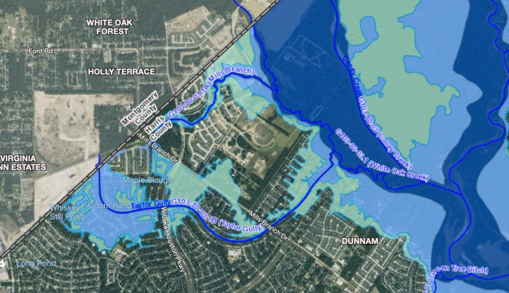
Mills Branch (the creek) originates in the woods in the upper left. Mills Branch then goes through Woodstream Forest and Royal Brook before joining White Oak Creek and Caney Creek.
https://i0.wp.com/reduceflooding.com/wp-content/uploads/2021/09/20210921-DJI_0465-2.jpg?fit=1200%2C800&ssl=18001200adminadmin2021-09-21 16:56:392021-09-21 17:05:28Humble ISD North Transportation Center Now Complete, New Ag Barn Getting There
A new flood-insurance rating system, designed to make rates reflect the true risk to an individual property will go into effect on October 1. FEMA calls it their Risk Rating 2.0 system. They describe it as Equity in Action. It’s FEMA’s attempt to put the National Flood Insurance Program (NFIP) on a sound actuarial footing and stop the system’s financial hemorrhaging.
“The new system moves away from basing price primarily on a handful of broadly drawn and often dated flood map zones,” according to the Pew Charitable Trusts. The new rates reflect “a more detailed set of factors, including proximity to and size of a water source, flood frequency and type (such as heavy rainfall or coastal erosion), ground and building elevation, foundation types, and drainage issues.”
Source: FEMA Presentation in MaapNext MeetingSource: FEMA Presentation in MaapNext Meeting
Sliding Scales not Price Brackets
“The more detailed analysis allows for prices that run along a sliding scale,” says Pew, rather grouping homes into brackets because they’re in the same mapped zone. Thus, low-risk homes will no longer be carrying the freight for high-risk homes.
Under Risk Rating 2.0, policyholders can save through mitigation activities such as elevating mechanical and electrical equipment above flood levels or installing flood openings.
Also, under the old system, all National Flood Insurance policy holders paid the same base rate. However, they could purchase additional insurance at substantially discounted rates. Thus, more expensive homes enjoyed an advantage over less expensive homes. But the new system will attempt to correct that imbalance.
Risk Rating 2.0 also gives policy holders savings for practical mitigation activities, such as elevating mechanical and electrical equipment above flood levels or installing flood openings.
So far, so good. Congress mandated the change to actuarily sustainable rates in 2012. At the time, people thought the rates would also help discourage development in flood prone areas.
A google search turned up many news stories about fears of massive rate increases. However, by law, most new rates may not increase by more than 18% per year, according to FEMA.
Gap Between Policies and Practice, At Least Initially
Still, several insurance companies have pointed out hidden inconsistencies between policy and practice in the new system.
A new artificial rate cap. Under Risk Rating 2.0, regardless of risk, policyholders will never pay more than $12,125 per year. This effectively creates a subsidy that encourages development in the most flood-prone areas.
Rates still do not align with risk. Current policy holders will not be penalized for any losses during the past two decades. That said, the artificially low rate will immediately increase to reflect actual risk after the first claim under Risk Rating 2.0. For a period at least, the NFIP provides no way for homebuyers to discover the flood-loss history of a structure.
Rate discounts unrelated to specific risk will continue. The NFIP’s Community Discount System will continue to provide community-wide premium reductions regardless of an individual property’s risk. These reductions impact more than 70% of NFIP policies and provide discounts of up to 45% to every structure in the community regardless of actual risk.
There are still no refunds for many policyholders who want to trade up. Once an NFIP policy has been in force for more than 30 days, the NFIP will not allow a refund to a policyholder who cancels an NFIP policy and replaces it with private coverage.
Pushback from Politicians
Several senators and congress people have complained about the new system and asked to delay the rollout to study impacts more closely.
The influential, Washington publication “The Hill” published a scathing op-ed of Risk Rating 2.0 in May. The author, Jainey Bavishi, director of the NYC Mayor’s Office of Climate Resiliency, felt that rising costs would force many to let flood-insurance policies lapse. She called the rollout “rushed.” She claimed, and I quote, the new policy “threatens to transform the National Flood Insurance Program from a financial lifeline into a crippling financial burden for thousands of low-income families in coastal cities.”
Phased-In Changes
Any change this massive was bound to cause political indigestion. FEMA has heard the criticisms and is trying to roll out the new system in a way that minimizes hardships. For instance, existing policies will be on an 18% “glide path” to their full risk rate. Said another way, FEMA will phase in the increases to make them more bearable. They will also give discounts for flood proofing, adding flood vents beneath homes, elevating homes and much more.
For policy holders in multi-floor apartment buildings, FEMA will now consider the actual floor you live on, not just quote a flat rate for everyone in a building. This should benefit renters who live on upper floors.
Timing
PHASE I
New policies beginning Oct. 1, 2021, will be subject to the new rating methodology. Also beginning Oct. 1, existing policyholders eligible for renewal will be able to take advantage of immediate decreases in their premiums.
PHASE II
All remaining policies renewing on or after April 1, 2022, will be subject to the new rating methodology.
Get a Quote From Your Insurance Agent
In its efforts to make pricing reflect true risk, FEMA will now consider many new data sources and variables. I reviewed an hour-long FEMA presentation on the subject. At the end, I was left with one overwhelming conclusion. Call your insurance agent. Your price may go down. It may go up. It costs nothing to get a quote. But the cost of NOT having insurance when you need it can break the bank as we saw during Harvey and Imelda.
1483 Days since Hurricane Harvey and 732 since Imelda
https://i0.wp.com/reduceflooding.com/wp-content/uploads/2021/09/20210908-Screen-Shot-2021-09-08-at-4.24.22-PM.jpg?fit=1200%2C673&ssl=16731200adminadmin2021-09-20 15:51:182021-09-20 15:54:46New Flood-Insurance Rating System Starts October 1
For an engineering study, it’s exceptionally easy to understand and the recommendations were prophetic. It almost reads like a primer for flood control.
Recommendations of specific projects aside, the principal recommendations are as valid today as they were then. Had only someone acted on them.
Make sure you at least read Chapter 5: Conclusions and Chapter 6: Examination and Recommendation of Basic Design Criteria for Watershed. Together, they total just five pages.
Purpose of Upper San Jacinto Study
The Upper San Jacinto study had four main goals:
Develop a comprehensive stormwater drainage plan
Recommend specific improvements
Evaluate/compare alternatives
Provide drainage authorities with information necessary to control flooding.
Problems of Rapid Development in Flat Areas
The study begins with a discussion of the problems of rapid development in flat areas. The Upper San Jacinto Watershed covers 1200 square miles. It includes all of Montgomery County and parts of Walker, Grimes, Waller, San Jacinto, and Liberty Counties. For the purposes of this study, the Harris/Montgomery County line formed the southernmost boundary.
Seven major streams comprise the watershed: the West Fork, Lake Creek, Spring Creek, East Fork, Caney Creek, Peach Creek, Luce Bayou and Tarkington Bayou.
The topography changes from rolling hills in the north and west to flat coastal plains in the south and east. The lack of slope in the southern and eastern regions seriously affects the ability of streams to drain stormwater.
The authors warned that as development would move northward, hydraulic “improvements” would alter natural stream patterns by increasing flow velocities and reducing ponding.
Without sufficient retention, development can accelerate runoff, leading to faster, higher peaks that contribute to flooding.
Even before urban development, they said, channels in the Upper San Jacinto Watershed did not have adequate capacity to transport runoff from large storms.
In 1985, at the time of the report, less than 5% of the land area in the watershed was developed. The Woodlands was relatively new and still building out. The report warned that because of development, increases in impervious cover “will require a more efficient drainage system to collect and transport runoff.”
The report lauded the type of development in The Woodlands, where, “discharges are no higher today than they were years ago in the undeveloped stages.” However, the report also cautioned that “…with most of the current development in the southern and eastern extremities of Montgomery County, watershed flooding problems may be greatly enhanced by urbanization.”
The chapter which discussed planning said, “Right of way and reservoir land acquisition should occur while the land is open and available.” Sadly, with the exception of Lake Conroe, which had already been built, none of that happened.
Benefit/Cost Ratios of Regional Detention in Undeveloped Areas
The last advice sounds so simple, one wonders why no one acted on it. However, as I read through the economic analyses of alternatives (reservoirs, channel improvements, etc.), the reason became blindingly clear.
So few people lived in undeveloped areas in the Upper San Jacinto Watershed in 1985 that the annual flood damages are minuscule. For instance, there were only 39 structures in four Lake Creek floodplain areas that the authors examined. Annual damages totaled only $9,600. That made the Benefit/Cost Ratios (BCRs) for the various mitigation alternatives that they developed come out to less than .001 in some cases and .09 at most. Benefits equal costs at 1.0. So FEMA usually demands BCRs exceed 1.
But compare the cost of a reservoir then and now. In 1985, the authors estimated the total cost of a Walnut Creek reservoir (a tributary to Spring Creek) to be only $41,000,000. Today, the cost would be $132 million – more than 3X. But it would take many more homes out of the floodplain. So the BCR today could be 1.04 making the project doable (see page 44)…although much more expensive and much to late to help those who flooded recently.
To get around this problem, the Harris County Flood Control District started its Frontier Program. The program buys up land for regional detention ponds (those that serve multiple developments), and then resells detention capacity back to developers for future use. Because regional detention is usually more efficient than developers building individual detention ponds on their own, it can actually lower developers’ costs while protecting the public and conserving money long term.
Most High-Level Recommendations Still Valid
Page 43 of the 1985 report makes six high-level recommendations (apart from specific projects) that are as valid today as they were then.
Create a central agency to control, monitor, remedy and finance flood control for the entire watershed.
Control development within the 100-year floodplain and prohibit it in the floodway with laws and regulations.
Establish minimum building slab elevations in flood-prone areas.
Limit fill in the floodplain.
Develop procedures to follow when allowing floodplain development, i.e., not obstructing 100-year floods.
Develop specific criteria, procedures and requirements for downstream impact analysis to compare Development A with Development B, and to analyze their combined effects.
Regular readers of this site have heard many of these recommendations before. The surprise, if there is one, is that we haven’t adopted them all already or that we haven’t adopted them consistently. Even where recommendations have been adopted, they are enforced inconsistently.
For future reference, the 1985 report can also be found on the reports page under the SJRA tab.
Posted by Bob Rehak on 9/19/2021
1482 Days since Hurricane Harvey and 731 since Imelda
https://i0.wp.com/reduceflooding.com/wp-content/uploads/2021/09/Screen-Shot-2021-09-19-at-1.24.59-PM.png?fit=1084%2C1198&ssl=111981084adminadmin2021-09-19 15:07:542021-09-25 18:48:421985 Upper San Jacinto Flood Control Study Prophetic, But Largely Unheeded
The Texas General Land Office (GLO) has announced that the public comment period for the first amendment to the state’s action plan for Community Development Block Grants for Mitigation (CDBG-MIT) will close in twelve days – on September 29, 2021. The GLO first posted the amendment to its $4.3 billion action plan on August 23rd.
Harris County essentially got shut out of the first round of grants last summer. This amendment would allocate $750 million to Harris County in the second round. That’s good as far as it goes, but Harris County needs more and the proposed amendment needs tweaks. Read more below.
Townhome destroyed by 240,000 cubic feet per second during Harvey.
Background
Earlier this year, the GLO held a statewide competition for approximately $1.1 billion in Harvey flood mitigation funds. Harris County received none, despite being one of the most heavily populated and impacted counties in the state.
A public uproar ensued. GLO Commissioner George P. Bush then agreed to commit $750 million to Harris County for the second round of funding.
The amendment also obligates the county to define a method of distribution (MOD) for that money within US Department of Housing and Urban Development (HUD) rules.
The amendment is based on a Method of Distribution (MOD) program. It makes the GLO the direct recipient of HUD funds and Harris County a sub-recipient.
Harris County must define the MOD plan to allocate funds to eligible entities within rules defined by HUD.
Eligible entities include:
Local governments (cities/towns)
Special purpose districts (MUDs/improvement districts/drainage districts, etc.)
Ports
River authorities
GLO encourages prioritization of projects that meet regional mitigation needs.
Harris County’s MOD plan must benefit at least 50% LMI (low-to-moderate income) residents.
Eligible activities include:
Flood control and drainage improvements
Infrastructure improvements
Natural or green infrastructure
Communications infrastructure
Public facilities
Buyouts
Relocation assistance to outside of floodplains
Public service (housing, legal, job, mental health and general health counseling with a 15% cap)
Economic development
Elevation of critical structures
Planning (5% cap)
Ineligible activities include:
Emergency response services
Enlargement of a dam or levee
Assistance for privately owned utilities
Improvement of buildings used by government
Funding USACE projects in excess of $250,000
Projects involving use of eminent domain that benefit private parties
Buyouts
Have their own guidelines which are too complicated to summarize here.
Timeline
The clock starts ticking 4 months after HUD’s approval of Amendment #1.
50% of the grant must be expended by Jan. 12, 2027.
100% must be expended by January 12, 2032.
Experts say all this time may be needed given the complexity of navigating HUD processes, which are lengthier than other sources.
Discussion/Recommendations
Harris County and the Flood Control District support the amendment. It is certainly justified by the number of people in Harris County and the amount of damage inflicted by Harvey.
However, $750 million is not enough. A fairer amount would be closer to $1 billion. As the action plan points out, approximately one third of Harris County went under water during Harvey.
Alan Black, interim executive director of the Harris County Flood Control District, points out several other reasons for increasing the allocation:
The City of Houston has still been left out. Flooding in Harris County has a dual nature. “You can address the rivers and channels,” he says, “but if water can’t get to the bayous, people will still flood when water ponds in neighborhoods. Both riverine and street flooding must be addressed together.”
Black also points out that administrative fees are capped at 6%, but with HUD compliance costs, 8% is more realistic. Moreover, those administrative costs must come out of the $750 million – they are not on top of it. So the real amount of money available for flood mitigation would be reduced to about $690 million.
Finally, the Amendment also allocates approximately $450 million to Houston/Galveston Area Council, much of which would go back into the City of Houston. Black points out that flood mitigation is the Flood Control District’s core competency and that HCFCD can construct projects much faster and more efficiently than HGAC.
An estimated one third of Harris County went under water during Harvey. Photo courtesy of Sally Geis before her rescue.
But he worries about inflation of construction costs (which he is already seeing) and the admin costs.
Black intends to build projects as quickly as he can. If there’s a project in an LMI neighborhood that’s shovel ready, he will build it with bond money and not wait for HUD funding which could add years of delays.
That said, there are many projects that are not shovel ready that could benefit from this money. In fact, the need is greater than available funding, says Black.
Make Your Feelings Known
Please consider these points and take time to submit a public comment. Email is probably the easiest way. It doesn’t require you to wait through a meeting for your turn to speak, and doesn’t limit you to a certain amount of time.
Photo by Camille Pagel. Her children are helping to gut the kitchen instead of going to school after the Harvey flood.
How to Register Your Opinion
You can register your opinion in any one of five ways.
US Mail: Texas General Land Office Community Development and Revitalization, P.O. Box 12873 Austin, TX 78711-2873
Fax: 512-475-5150
All public comments submitted by 5 p.m. on Sept. 29, 2021, will be considered. The method of submittal does not matter. Per federal requirements, the GLO will respond to public comments before the amendment is sent to HUD for final approval.
Posted by Bob Rehak on 9/17/2021
1480 Days after Hurricane Harvey
https://i0.wp.com/reduceflooding.com/wp-content/uploads/2021/09/20170829-IMG_5756.jpg?fit=1200%2C800&ssl=18001200adminadmin2021-09-17 20:15:172021-09-17 20:25:58Help Needed: Public Comment Period Swiftly Closing on $750 Million HUD Flood-Mitigation Grant for Harris County
In August 2017, Sally Geis and her husband JG watched as Harvey’s floodwaters crept over the San Jacinto West Fork river bank. They thought they would be safe. But soon rising water turned to raging water. As they moved upstairs, they took a hatchet. JG said it was to kill snakes that got in the house. But Sally wondered if it was to chop a hole in their roof in case they needed an escape hatch.
Sally’s rediscovered cache of photos creates a valuable addition to our understanding of how Harvey’s floodwaters rose and spread in the Kingwood area.
Before Waters Rose
West Lake Houston Parkway Bridge over West Fork San Jacinto before the flood.August 25th, 2017, 11:09 a.m.
Waters Begin to Rise
August 27th, 2017 at 7:17 a.m. Note how much closer the level of the water is to the bridge and how part of the boat dock is under water.
River Fully Out of its Banks
August 28, 2017 at 10:44 p.m. Boat dock is completely under water. Street signs visible in earlier photos are almost completely submerged.
Serious Trouble
August 29, 2017 at 8:35 a.m. Street signs are under water but top parts of light poles are still visible. Note bridge on far right. Water almost touches bridge in center. But at far end on Atascocita side, the road bed is tangent with the river. All surface features in foreground are submerged.
River Rescue
Soon a boat was the only way out…a boat which snatched them from the second story of their home.
Said Sally, “The current was very fierce — he really knew what he was doing!! We could touch the tree tops and the street name signs overhead!”
Geis rescue during Harvey. Two men from Paris, TX drove 6 hours with their boat to help. Sally said they had to rev their engine up to full speed to fight the cross current. Notice the churning waves among the trees in the background as they make their way north on West Lake Houston Parkway to the drop off point.August 29, 2017 at 6:55 P.M.
The picture above was taken north of Kingwood Drive almost two miles from the main channel of the West Fork. Yet look at that turbulence in the water. Normally, a point this far from a river would be designated as “floodplain storage.” Normally, that would mean placid waters, the opposite of what you see.
Eventually, the rescue boat dropped Sally and JG off at Wendy’s on West Lake Houston Parkway at Rustic Woods, several blocks north of where the photo above was taken. From there to the water’s edge on the south side of the West Fork is approximately 2 miles…wider than the widest part of Lake Houston itself – just upstream from the spillway – during normal times.
Eventually the river became wider than Lake Houston normally is.
From Wendy’s, a car ferried Sally and JG to a volunteer’s home where they slept the next night.
Day After Explorations
The following day, they explored the area on foot, still in shock, surveying all the damage. Water remained high in many places. Rescue operations continued.
At Woodland Hills and Tangle Lake, rescue efforts continued. August 30, 11:26 AM.
Shady Run at Kingwood Drive. Water normally flows from left to right here. But note how the trees appear to have been pushed from right to left. August 30, 2017 at noon.
At the same intersection, water reached halfway up street signs. August 30, 2017, 12:07 PM
Revisiting the Escape Route Days Later
“We went OVER this bridge in the boat!!” said Sally Geis.
West Lake Houston Bridge over Bens Branch after water receded. Photo taken 9/1/2017. Geis says her rescue boat went OVER, NOT UNDER THESE BRIDGES.
According to Geis, on the way out, rescue-boat propellers kept striking submerged cars, nearly capsizing boats on more than one occasion.
Photo taken 9/1/2017 after water receded. Car destroyed by propeller of rescue boat was totally submerged when struck. Side window was likely blown out by water pressure.
“A lot of boats were hitting submerged signs, cars, heavy things — they had no idea what was underwater. One boat hit a car, began to sink and nearly capsized. Thankfully it didn’t. A lady onboard could not swim. The water was over our heads and the current was scary and swift, plus contaminated. I heard there were 500 rescue boats in all — including the Cajun Navy, helicopters, jet skis,” said Geis.
After Shocks
Sally and JG lost their vehicles in the flood. And like so many others, they lost all the belongings on the lower floor of their home. Here is a short video of a scene they filmed on a walkabout after Harvey’s floodwater’s receded.
Video of Harvey Debris in Kingwood, TX by Sally Geis. Shot September 3, 2017, at 5:29 PM.
Sally’s brother later picked the couple up when the water receded and took them to a friend’s home. The friend was on vacation, so they got to rest up for five days before facing the destruction.
Says Sally, “Those images of every street lined with trash – of complete households hauled to the curb – for months on end added to the depression and PTSD.”
Geis and her husband spent the next two years restoring their home.
After fighting developers who wanted to build in the floodway of the West Fork, they finally sold their home earlier this year. They now live in a high rise downtown.
Sally says, “People who have never been through an experience like this have no idea how real the PTSD can be. It can take over your life.”
Posted by Bob Rehak on September 16, 2021, based on the photos and memories of Sally Geis
1479 Days since Hurricane Harvey
https://i0.wp.com/reduceflooding.com/wp-content/uploads/2021/09/20170829-IMG_9819.jpg?fit=1200%2C900&ssl=19001200adminadmin2021-09-16 19:52:032021-09-17 08:24:39Day of Terror Relived: Sally Geis’ Harvey Evacuation Story
Four years after Harvey, the storm’s effects are still visible at Alspaugh’s Hardware Store in Kingwood’s Town Center. To this day, Rick Alspaugh struggles to balance inventory with service, the thing that made his business formula unique. This is the story of how Harvey affected him, his business, his customers and 60 employees.
Bob: Your family’s first hardware store in Kingwood was up near the front. When did you move to Town Center?
Rick: We bought our property from Friendswood in 1993 and opened our store in ‘94.
Rick Alspaugh (center), wife KellyAnnette (right) and manager Dallas Behman (left)
27 Years of Success Based on Unique Formula
Bob: You’ve been there 27 years! Did the entry of Lowe’s into the market affect your business?
Rick: Not really. They don’t do what we do.
Bob: How would you characterize that?
Rick: They have great inventories. But we have people who can walk you through a project. We were the go-to place for service. People don’t come here for lumber, tile, sinks and carpet. They come for parts, paint, smaller things. And we have this amazing boutique with unique things that nobody else carries. With goods at all price levels. Plus free gift-wrapping. You can’t get that anywhere else in the city.
Back before Harvey, we also had a huge selection of barbecue equipment. We’re struggling right now, but God’s going to get us through it.
Bob: Let’s go back to Hurricane Harvey.
3.5 Feet of Water in 16,000 SF Store, But No Flood Insurance
Rick: August 28th 2017. I’ll never forget it. Everything went underwater. Deep under water – three and a half feet.
Alspaugh’s during Harvey
We lost twenty-seven computers. They were all on desktops, but that wasn’t high enough.
The height of Harvey’s floodwaters meant Alspaugh lost 27 computers sitting on desktops – all but one in the paint department.
Bob: Were you insured for that?
Rick: Not a bit.
Bob: (shocked) You didn’t have flood insurance?!
Rick: About a month before Harvey, my insurance agent came in. We talked about how we had grown and increased my coverage. Then Harvey hit. I’ll come back to that in a minute.
60 Employees Help Jumpstart Business
Rick: At the time, I had about 60 employees. The day after Harvey, everyone showed up and started cleaning. It was amazing, Bob. They rebuilt the store. It was unreal. It was just… We came together!
Within three days, we were able to open by working out of trailers and a cargo container outside with one surviving computer from the paint department. We ran wires out there. And we re-opened out of that container.
I ordered about $400,000 worth of stuff that people would need for cleanup.
“I Just Assumed I Had Flood Insurance”
Rick: In the flood, we also lost three trucks. A generator. And our forklifts. I used up all my cash reserves to get going again and keep people working. So, I called my agent to make some insurance claims and he says, “For what?”
“We flooded in Harvey! This was a total loss,” I said.
Alspaugh tossed his entire inventory, fearing contamination from a sewage treatment plant just upstream.
He goes, “You’re not covered for rising water. You don’t have flood insurance.”
My agent never once asked me if I wanted flood insurance. And I never asked if I had it. I just…assumed. I assumed I had it.
Luckily, the three trucks were covered under our automotive policy. So, I got money for them. But it was not enough to replace them.
Bob: How long did it take to reopen?
Doing Business Outside While Rebuilding Inside
Rick: By September 1st, we were selling outside. But for all of September and October, and most of November, we were rebuilding the inside.
At lunch, our barbecue vendor came in to cook for us. We would pressure wash the tables, turn a bunch of buckets upside down, sit, pray, and eat. That really brought us together.
Before the store was even cleaned out, I targeted reopening inside for the Saturday before Thanksgiving. Everyone just looked at me with giant eyes. But by God, we got to work. And we made it happen.
Bob: Were there any setbacks?
Rick: We received three 18 wheelers of shelving…in the wrong order. We needed uprights first. But they came on the last truck…a week late. So, we literally lost a week of assembly. But we were back in the store by Monday before Thanksgiving.
Bob: Wow.
Rick: In about eight weeks, we completely redid the store. But that was eight hours a day for 60 people.
Starting over from the ground up
$3.2 Million in Flood Losses
Bob: How much did you lose in Harvey?
Rick: $3.2 million dollars. We lost the entire inventory. We trashed it all because I was concerned about contamination. It was nasty. We’re less than a quarter of a mile downriver from Kingwood’s main sewage treatment plant. We just had to trash everything.
Store interior after floodwater receded. Note water line on standing cardboard cartons.
But when we reopened, everything was 100 percent clean. Brand new. We threw out everything touched by Harvey. Four trailer loads of barbecue pits were crushed and hauled straight to the scrap yard.
Even the barbecues, his signature product line, went to the dump.
Bob: I had no idea. Did any of the newspapers write that story?
Rick: No. I never felt I was special to where I needed to talk about it. All the people around me suffered similar losses. The jewelry store. The photofinisher. The barbershop. The cupcake guy. Everybody in Town Center lost everything.
Bob: Did you ever think the water would get this high?
Rick: I knew it could reach Town Center because of the 1994 flood. So, during Harvey, we tried to raise everything up about a foot. But I never thought three and a half feet!
If you had three and a half feet of snow, it would melt by next week and it would be business as usual. But when you have three and a half feet of water in your store…well, here I am talking about the recovery four years later.
Plagued by PTSD
Bob: How has this affected you personally?
Rick: People don’t realize how real PTSD is. I have my eye on the Weather Channel all the time now.
Bob: Do you have flood insurance now?
Rick: Yes, sir. And I’ve got a different insurance agent, too.
Business Since Harvey
Bob: So, you lost $3.2 million worth of inventory and computers. You had to start over. Without help from insurance. How has Harvey affected your business since then?
Rick: Harvey not only destroyed our store, it wiped out 3000 homes within a nine-iron shot of here. This entire neighborhood…gone. Customers didn’t need most of what I had at that point. They needed major remodel stuff: carpet, tile, wallboard, like that. They needed contractors, not light switches. Plus, they didn’t have flood insurance and had to bear the cost of recovery out of pocket.
We have problems. But not like most people. We’re not on the way to M.D. Anderson. Having burned through my own savings, I just don’t have enough money to offer the kind of service people came to expect.
Government Grants Slow in Coming
Bob: What comes next?
Rick: We’re poised to recover. I just need inventory. We filed for some Harvey help.
I got some tax relief, which was very nice. An SBA loan which we’re paying back. The Humble Chamber helped us, which was a huge blessing.
Congress appropriated $100 million to small businesses for Harvey grants. But they take forever. Worse, they had $250 million worth of need.
Luckily, friends in the community stepped up to help fill that gap. That’s why we are here today. I’m not begging friends anymore. I’m just not. But I would like to get some of this Harvey aid. I certainly qualify.
Banking on Community Spirit
Bob: So where do you go from here?
Rick: We’re here every day. The lights are on. And we still have stuff to sell. Just not as much as we used to.
Bob: You know, I can’t imagine cooking barbeque without your store.
Rick: Thank you.
Bob: I see Alspaugh’s as a central location for community spirit.
Rick: It used to be. And it can be again. There’s not a whole lot that we can’t do as a community.
Posted by Bob Rehak on September 15, 2021 based on an interview with Rick Alspaugh
1478 Days since Hurricane Harvey
https://i0.wp.com/reduceflooding.com/wp-content/uploads/2021/09/20170830-IMG_1542.jpg?fit=1200%2C895&ssl=18951200adminadmin2021-09-15 17:36:212021-09-15 21:19:59The Long Road to Recovery: Rick Alspaugh’s Harvey Story
Still, with hurricanes, you prepare for the worst and hope for the best. And in the end, we got the best of Nicholas. Even the power outages happened in the middle of the night when most people were asleep.
Results of Scouting Trip This Morning
A scouting trip this morning showed the worst never materialized here. That’s not to say that we were damage free. I saw numerous downed trees, signs blown over, and water filling roadside ditches. But, thankfully, no flooded homes! There may have been some; I just didn’t see any.
Kingwood Drive and Green Oak Drive in Kingwood.A sign of high winds during the night.See more images below.
Modest Rainfall Spread Out over Time Kept Bayous in Banks
As of 11 AM on Tuesday 9/14/2021, all streams and bayous in Harris County were within their banks, winds were dying down, and the worst part of the storm had moved off to the east.
I had 3.7 inches of rain in my gage for the last two days, which is largely consistent with other gages in the area. The gage at US59 and the West Fork San Jacinto recorded 3.04 inches over a two-day period. The rain was gentle and spread out. The heaviest downpour occurred Monday afternoon between 1 and 2 PM when we received .64 inches in a few minutes. But that volume was well within the capacity of storm sewers which can generally handle 1-2 inches per hour.
Mostly gentle rains were spread out enough to avoid flooding.
The stream gage at the same location showed the effects of lowering Lake Houston then the heavier parts of Nicholas’ rainfall.
The rest of the City and County fared pretty much the same, with the exception of the far south and eastern portions.
Two-day rainfall totals for Harris County during Nicholas. Note the sharp differences between north and south, and east and west.
Only Clear Creek came out of its banks as of 11 AM Tuesday morning.
The Kingwood Diversion Ditch was well within its banks. Photo taken at Kingwood Drive.
The diversion ditch was typical of every ditch I checked in Kingwood. All were well within their banks.
Satellite Imagery Shows Worst of Nicholas Now Off to East
Visible satellite images show the distinctive “comma shape” of Nicholas.
Visible satellite image as of 11 AM Houston time on 9/14/2021shows much of Houston area still covered in clouds...
…But an infrared image taken minutes later shows the heaviest rains have moved east. Infrared images measure the cloud tops.
This water vapor image taken at the same time confirms that the storm is focused east of us now.
Downed Trees, Debris, and Power Outages will be Biggest Problems for Most People
Gus, the poodle, inspects a downed tree at Alligator Alley in East End Park. Note all the smaller debris scattered on the trail, too. That was typical of streets in the Kingwood area today.Photo courtesy of John Knoezer.
It will take a while to recover from the storm, but nothing like Harvey, Imelda, or even May 7, 2019. As of this morning, there were power outages randomly affecting neighborhoods and commercial areas. Some places seemed to be operating normally; others still lacked power. About every third traffic light was blinking.
I personally lost power several times throughout the night for a total of about six hours.
What Next for Nicholas?
According to the National Hurricane Center at its 10 AM update this morning, doppler weather radar data from Houston and Lake Charles, along with surface observations, indicate that Nicholas has continued to weaken while moving farther inland.
The strongest winds recently reported near the Texas and Louisiana coasts have been 33-35 kt (40 mph) near Sabine Pass, Texas. The estimated central pressure of 1002 mb is based on surface observations in Houston. Further weakening is expected as Nicholas moves farther inland due to frictional effects, entrainment of very dry mid-level air from the southern Plains, and increasing southwesterly to westerly shear.
Nicholas should become a tropical depression by tonight and degenerate into a remnant low by late Wednesday. Nicholas is now moving northeastward at only 5 kt. and should move even more slowly on Wednesday and Thursday. It is possible that Nicholas could stall over southwestern or central Louisiana. Although the winds associated with Nicholas will weaken, heavy rainfall and a significant flash flood risk will continue along the Gulf Coast during the next couple of days.
Posted by Bob Rehak on 9/14/2021 at 12:30 PM based on personal observations and data from NHC and HCFCD
1477 Days since Hurricane Harvey and 1 since Nicholas
https://i0.wp.com/reduceflooding.com/wp-content/uploads/2021/09/20210914-RJR_8799.jpg?fit=1200%2C800&ssl=18001200adminadmin2021-09-14 12:35:352021-09-14 12:50:06Nicholas Largely Spares Lake Houston Area
As of its 10 PM CDT update on 9/13/2021, the National Hurricane Center (NHC) upgraded Tropical Storm Nicholas to a hurricane.
Nicholas a Minimum Cat 1 Hurricane
A weather station at Matagorda Bay reported sustained winds of 66 kt (76 mph) with a gust to 83 kt. NHC expects no additional strengthening before the system makes landfall. Gradual weakening is expected during the next 2-3 days while Nicholas moves over southeastern Texas and southwestern Louisiana.
According to NHC, “Nicholas is currently moving through a weakness in a mid-level subtropical ridge. Within 12 to 24 hours, after Nicholas has moved inland, the ridge should weaken and leave Nicholas in an area of light steering currents. As a result, during the next couple of days, the cyclone should turn eastward and slow to a crawl near southwestern Louisiana.”
Nicholas should now reach the Houston Area with tropical-storm-force winds on Tuesday before slowing near the Louisiana border on Wednesday as a tropical depression..
The current 10 PM official forecast shows Nicholas moving more slowly than the previous forecast.
Key Messages
Heavy rainfall will impact portions of southeastern Texas, Louisiana, and southern Mississippi through the middle of the week. Significant rainfall amounts are expected, potentially resulting in areas of life-threatening flash and urban flooding, along the eastern Texas coast into southwestern Louisiana. Minor to isolated major river flooding is also possible in smaller river basins and urban areas.
There is the danger of life-threatening storm surge inundation along the coast of Texas from Port Aransas to Sabine Pass. Residents in these areas should follow any advice given by local officials.
Wind Force Probabilities Increasing
The probability of experiencing tropical-storm-force winds in the north Houston Area is very high.
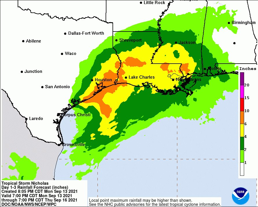
Rain Forecast Less Extreme in North Houston Area
However, the Weather Prediction Center now shows major rain accumulations only near the coast and to the east of Houston.
I already have 1.47 inches in my rain gage for today. The estimates above are for three days.
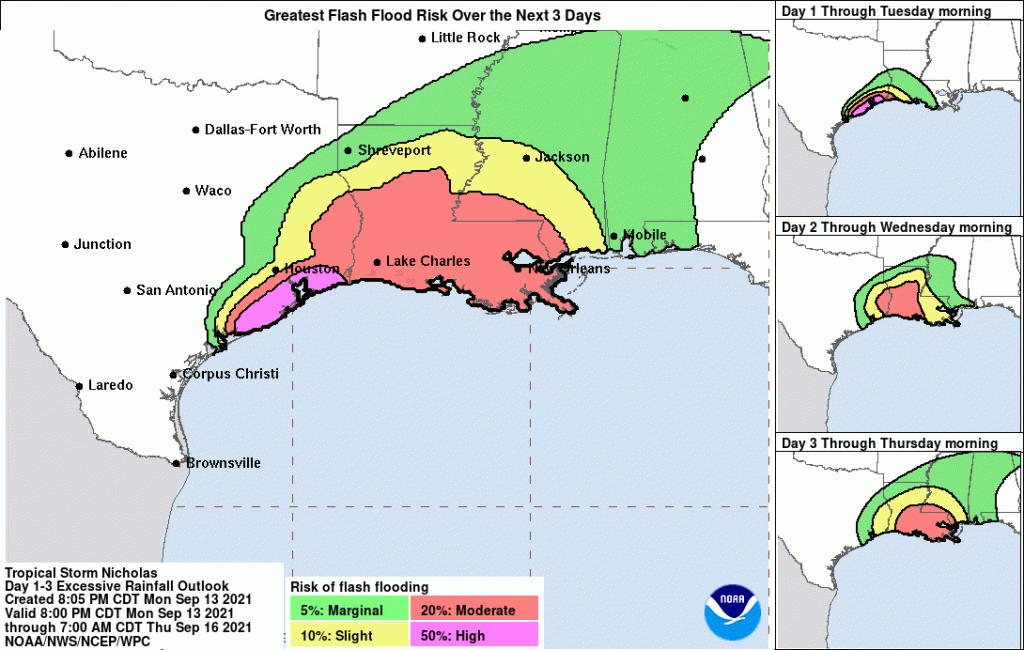
Flash Flooding Risk Now Mostly Along Coast
The risk of flash flooding mirrors the rainfall map above. The Lake Houston Area now has only a slight chance of flooding.
All in all, if the maps above are accurate, the Lake Houston Area could still see 2 to 6 inches of rain tomorrow, but that’s far better than previously predicted.
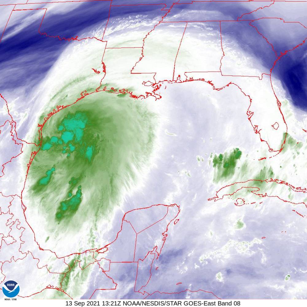
This infrared image shows the areas of heaviest rainfall as of 11:26 PM CDT 9/13/2021
Areas near the coast remain under a storm surge warning.
So far, none of the streams or bayous in Harris County have come out of their banks. To stay on top of potential local flooding on Tuesday, visit the Harris County Flood Warning System.
Posted by Bob Rehak at 11 PM Monday, 9/13/2021 based on information from NHC and HCFCD
1476 Days since Hurricane Harvey
https://i0.wp.com/reduceflooding.com/wp-content/uploads/2021/09/030938_5day_cone_no_line_and_wind.png?fit=897%2C736&ssl=1736897adminadmin2021-09-13 23:37:452021-09-14 00:10:27Nicholas, Now a Hurricane, Expected to Slow to a Crawl Near SW Louisiana
The 10 AM update from the National Hurricane Center shows that the eye of Nicholas is reforming yet again – further east from where it first reformed earlier today near Brownsville. This means that the cone of uncertainty for Nicholas has expanded. It now includes the entire Houston Area. And although chances of a hurricane are low, the hurricane watch has been extended northward to San Luis Pass.
Nicholas’ Cone Now Includes All of Houston
Remember that every place within the cone has an equal change of having the storm pass over it.
Main Threats from Tonight to Tomorrow Night
Bands of heavy rainfall and gusty winds continue to spread inland from the coast and will increase in frequency and intensity this afternoon into tonight. Core of Nicholas will move across southeast Texas….especially areas south of I-10 overnight into Tuesday with significant rainfall likely.
Harris County Meteorologist Jeff Lindner warns that while Nicholas is not forecasted to become a hurricane, it is possible that it could landfall as a minimal hurricane….but this does NOT change the impacts.
Impact Predictions Remain Unchanged Since Last Update
Significant rains will begin early this evening and likely continue into Tuesday morning.
Rainfall rates of 2-4 inches per hour will be possible yielding rapid street flooding and significant rises on bayous and creeks.
Lindner’s main concern is watersheds south of I-10 (Clear Creek, Armand Bayou, Vince and Little Vince Bayous, Keegans Bayou, and possibly Brays Bayou). However, Lindner still sees risk north I-10.
Some bayous and creeks may overflow their banks. Structure flooding is possible tonight. The majority of the rainfall is going to be tonight into Tuesday morning.
Residents should stay where they are after 6:00 PM this evening and remain there through the duration of Nicholas.
According to Harris County meteorologist Jeff Lindner, “The center of Nicholas has reformed overnight about 150 miles to the northwest of the previous center or just off the tip of the northeast Mexican coast. With the center reformation, the track timing has been moved up by about 12 hours.”
NOAA Satellite image taken at 7:06 am Houston time this morning.
Infrared image taken at 8:16 am Houston time this morning. Infrared imagery is useful for determining thunderstorm intensity. Strong to severe thunderstorms will normally have very cold tops.
Nicholas will now make landfall along the middle Texas coast later this afternoon or this evening.
National Hurricane Center
Said Lindner, “The center is now clearly defined on Brownsville radar and has been sampled by a USAF mission. The latest mission has found that the central pressure is starting to fall and is down to 1001 mb. Maximum sustained winds now reach 60mph. A large mass of very deep convection now extends several hundred miles into the Gulf of Mexico. Nicholas is moving toward the NNW around 14mph and will pass just offshore of Brownsville this morning. This will be a significant rainfall event for southeast Texas.”
Watches and Warnings Now in Effect
A Tropical Storm Warning is in effect for…
Mouth of the Rio Grande to High Island Texas
Barra el Mezquital to the U.S./Mexico border
A Tropical Storm Watch is in effect for…
East of High Island Texas to Sabine Pass
A Hurricane Watch is in effect for…
Port Aransas to Freeport Texas
Flash Flood Watch is in effect for:
Areas along and SE of US 59
A Storm Surge Warning is in effect for…
Port Aransas to San Luis Pass Texas
Aransas Bay, San Antonio Bay, and Matagorda Bay
Storm Surge Watch is in effect for…
Mouth of the Rio Grande to Port Aransas Texas
San Luis Pass Texas to Rutherford Beach Louisiana, including Galveston Bay
Baffin Bay and Corpus Christi Bay
Track
Forecasters predict a general northward motion toward the Matagorda Bay area followed by a gradual turn toward the NNE and NE. The forward motion of Nicholas will slow after moving inland over the TX coast.
Predicted track as of 7 am Houston time this morning. The storm should pass closest to Houston around mid-day tomorrow, but as a tropical depression. Note: the cone only indicates the potential path of the storm center, not the storm’s width, which can be much wider.
Intensity
Radar shows the Nicholas is attempting to form an inner core. However, moderate wind shear and dry air reaching into the center have slowed this process. With that said, Nicholas is now moving over very warm waters. Lindner predicts the shear may weaken over the next 8-10 hours. That may let Nicholas intensify close to hurricane strength at landfall. Nicholas should make landfall as a strong tropical storm or minimal hurricane.
Tropical storm force winds currently extend outward 115 miles…mainly to the east of the center.
NHC gives most of the Houston area a 30-60% chance of experiencing tropical-storm-force winds.
Impacts
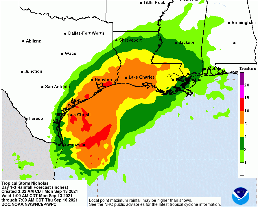
Rainfall:
Significant rainfall is expected along and east of the track of Nicholas. This rainfall may produce areas of considerable flash and urban flooding, especially in highly urbanized metropolitan areas. Additionally, there is the potential for isolated minor to moderate river flooding.
While rainfall totals are indicated over the 5 -7 day period, much of the rainfall is expected to fall over a 2-3 day period starting later tonight.
Coastal counties: widespread 10-15 inches (isolated totals up to 20 inches)
South/East of US 59: widespread 8-12 inches (isolated totals up to 15 inches)
North of I-10: widespread 4-6 inches (isolated totals up to 8 inches)
After landfall, models do not aon how quickly the tropical cyclone will move northeastward out of Texas. The forward speed is important to the heavy rainfall forecast, and this trend will be one to watch.
The usually conservative Space City Weather team warns that the flood threat in this event may compare to Tropical Storm Imelda and the 2016 Memorial Day weekend.
Rainfall will generally be heaviest near the coast with diminishing amounts as you move inland. However, training bands could create much higher than predicted totals in northern areas.
Water vapor satellite image captured at 8:21 Houston time this morning.
The National Weather Service’s Weather Prediction Center gives most of the Houston area a moderate risk of flash flooding, but some areas near the coast will have a high risk.
Winds:
Tropical storm force winds are likely along the coast from Matagorda to Galveston Bay and inland to the US 59 corridor. Sustained winds in the 65-75mph range will be possible over the Matagorda Bay region northward into Jackson and possibly southern Wharton Counties with sustained tropical storm force winds spreading inland into portions of Harris, Fort Bend, and Colorado Counties.
Tropical-storm-force winds could arrive in the Houston area later this afternoon.
Maximum sustained winds are currently near 60 mph (95 km/h) with higher gusts. Strengthening is forecast today, and Nicholas could reach the northwest Gulf coast as a hurricane. Weakening is anticipated on Tuesday and Wednesday while Nicholas moves over land.
Tropical-storm-force winds extend outward up to 115 miles (185 km) from the center. South Padre Island recently reported a wind gust to 45 mph.
Tropical storm conditions are expected to first reach southern Texas this morning, making outside preparations difficult or dangerous. These conditions will spread northward within the warning area through tonight. Hurricane conditions are possible in the Hurricane Watch area as early as this afternoon. Tropical storm conditions are possible within the watch area by tonight or early Tuesday.
Tides:
Expect storm surge of 3-5 feet from Port O Connor to Sargent and 2-4 feet from Sargent to High Island above normal dry ground. Some significant inundation is possible around Matagorda Bay. Additionally, waves on top of the surge will result in significant beach erosion and wave run-up.
Areas NE of Galveston Bay could experience 2-4 feet of storm surge, while areas SW could experience 3-5.
Gradual Weakening Predicted
Nicholas should weaken after landfall, diminish into a tropical depression within a couple of days, and degenerate into a remnant low in about 3 days.
Key Messages
Heavy rainfall will impact portions of the Texas and Louisiana coasts through the middle of the week. Significant rainfall amounts are possible, potentially resulting in areas of considerable flash and urban flooding, especially in highly urbanized metropolitan areas. Isolated minor to moderate river flooding is also expected.
There is the danger of life-threatening storm surge inundation along the coast of Texas from Port Aransas to San Luis Pass. Residents in these areas should follow any advice given by local officials.
Nicholas is forecast to approach the middle Texas coast as a strong tropical storm today, and could be near hurricane intensity at landfall. Tropical storm conditions are expected along portions of the middle Texas coast beginning by this afternoon, with hurricane conditions possible from Port Aransas to Freeport this afternoon and tonight.
Tropical storm conditions are expected along portions of the northeastern coast of Mexico and the coast of south Texas beginning during the next few hours.
Posted by Bob Rehak on 9/13/2021 at 8AM based on information from HCFCD and NHC
1476 Days since Hurricane Harvey
00adminadmin2021-09-13 08:46:112021-09-13 08:56:24Eye of Nicholas Reforms, Timetable Moved Up