Since my last update, Kingwood Middle School (KMS) reconstruction has progressed nicely despite heavy rains and a tropical storm in the last month. My rain gage, a few blocks away recorded more than 11 inches of rain in the last 30 days – almost triple the average for September.
My last update on August 20 showed that contractors had erected most of the structural steel, but large parts of superstructure were still open. Today, almost the entire roof is on and most of the structure has been walled or glassed in.
Photos Showing Status of KMS Reconstruction as of 10/3/21
Here are pictures of KMS reconstruction taken this afternoon with a drone.
KMS reconstruction as of 10.3.21. Looking SE from over Woodland Hills Blvd.
Looking N across roof of old KMS. Woodland Hills Blvd on left. Note how left (western) part of building is already bricked in. When new KMS is complete, the old one will be torn down.
Plans call for reconstructing the athletic fields on the site of the old school and building a permanent, larger detention pond where the circular drive in the foreground is.
It’s hard to tell from this angle, but temporary detention pond had barely emptied from yesterday’s deluge.Only one small section in lower left remains without roof. The new KMS will go up instead of out to create the needed capacity for studentsAs construction moves in phases from NW to SE, you see different degrees of finish.
For this round of funding, the TWDB selected 19 sub-applications from local government entities. After screening, FEMA eliminated 6 and identified 13 “for further review.”
Here’s a summary from the TWDB of what they will vote on.
Harris County Drainage Project in Bear Creek Village
Bear Creek Village is located on the west side of the Addicks reservoir near Highway 6. This is an $11.3 million project of which the federal government would pay $8.5 million.
The Harris County project would mitigate 1,421 structures. The current storm sewer system is designed for a 3-year event and is inadequate to collect and drain extreme event runoff. The proposed drainage improvements are intended to provide an additional flow path, so that excess storm water is contained within street right-of-way to an outfall. The project will incorporate a combination of channel construction, street regrading, and enhancement of outfalls. The project has a positive Benefit-Cost Ratio of 1.09.
Harris County Flood Control District Single-Family Home Acquisitions
Total cost = $16.7 million with federal government paying $14.7 million.
Harris County Flood District seeks to mitigate 61 structures: 23 Severe Repetitive Loss structures, 17 Repetitive Loss structures, and 21 at risk of continual future flooding. HCFCD would acquire and demolish structures, then convert the land to open green space. The project has a positive Benefit-Cost Ratio of 1.09.
Harris County Flood Control District Commercial Acquisition
This is a $3.7 million buyout with the federal government picking up the whole tab.
Harris County Flood Control District wants to buy out a hotel on the east freeway with a severe repetitive loss history. HCFCD would demolish the property and convert the land to open green space. The project has a positive Benefit-Cost Ratio of 1.84. The grant application notes that since 1979, FEMA has paid out $8 million in NFIP claims on this property.
City of Houston Single-Family-Home Elevation Project
Total Cost $1.5 million (all paid by federal government) to elevate 5 severe-repetitive-loss homes ($300,000 each). All would be elevated at least 2 feet above the 500-year floodplain. That would hopefully reduce or eliminate future NFIP claims. The project has a positive Benefit-Cost Ratio of 1.1.
Jersey Village Single-Family-Home Elevation Project
Total Cost $4.9 million with federal government covering $400,000.
Jersey Village seeks elevate 16 structures: 10 are Severe Repetitive Loss, five Repetitive Loss and one at risk of continual future flooding. Elevation will raise structures one-foot above Base Flood Elevation per the City’s freeboard requirements. The project has a positive Benefit-Cost Ratio of 1.32.
Montgomery County Single-Family-Home Acquisition and Demolition
Total Cost = $12.6 million with federal share of $12.4 million.
Montgomery County seeks to mitigate 40 flood prone structures (31 Severe Repetitive Loss and 9 Repetitive Loss structures) by acquisition, demolition, and the conversion of land to open green space. The project has a positive Benefit-Cost Ratio of 1.36.
Tammy Gunnels’ Home in Porter is an example of a Severe Repetitive Loss Home. It flooded like this 13 times in 11 years and was bought out yesterday as part of another Montgomery County grant.Before the buyout, it cost FEMA more than 3 times its fair market value and would have continued flooding had nothing been done.
Pearland Single-Family-Home Elevation Project
Total Cost $500,000, all covered by federal government.
The City of Pearland seeks to mitigate two Severe Repetitive Loss structures by elevation one-foot above the Base Flood Elevation per the City’s freeboard requirements. The project has a positive Benefit-Cost Ratio of 1.08.
Taylor Lake Village Single-Family-Home Elevation Project
Total Cost $2.77 million with federal government covering $2.75 million.
Taylor Lake Village wants to elevate eight Severe Repetitive Loss structures and one Repetitive Loss structure one foot above the 100-year flood level. The project has a positive Benefit-Cost Ratio of 3.1.
In each of the projects above, the owners have all voluntarily committed to the elevation or demolition of the structures.
Recommendation of TWDB Staff
The Executive Administrator of the TWDB recommends that his board approve all these grants. This program meets the agency’s objectives of providing financial assistance to communities to reduce or eliminate the long-term risk of flood damage and to become more flood resilient.
https://i0.wp.com/reduceflooding.com/wp-content/uploads/2018/12/Gunnels_01_01.jpg?fit=1500%2C844&ssl=18441500adminadmin2021-10-02 21:19:082021-10-02 21:19:12TWDB To Vote on Accepting $63.6 million in FEMA Flood Mitigation Assistance Grants
I first interviewed Tammy Gunnels and her husband Ronnie almost three years ago. They had flooded ten times at that point even though they weren’t in a flood zone. The Gunnels are devout people and prayed for a buyout. Friday, their prayers were answered. Here is the story of how their faith and persistence paid off in the long run. This interview also included Morgan Lumbley, the Disaster Recovery Manager for Montgomery County who guided the Gunnels through the application process.Ironically, the skies unleashed torrential rains just before the closing. But this time, everyone was smiling instead of worrying.
Ronnie Gunnels (left), Morgan Lumbley (middle), Tammy Gunnels (right) at Chicago Title in Montgomery for closing.
Early Frustration
Bob: You flooded 13 times in 11 years. Tell me how you finally got the buyout offer.
Tammy: After Harvey, one of my cleaning clients who’s an attorney vowed to find a way to get us a buyout. She put me in touch with the Office of Emergency Management for Montgomery County. Initially, they told me there were no open programs available.
Tammy: That was in 2017. Then in May of 2019, we flooded twice – on May 3rd and again on May 7th. Once more, I contacted their office and went to commissioners meetings, begging for a buyout. But nothing happened. After we flooded a third time that year during Imelda, I called their office just to scream and holler and cry into the phone. But this time, Morgan answered. I told her our story and by the end of the conversation, she was crying and promising that she was going to do everything she could.
Patience Finally Pays Off
Bob: And she wrote a beautiful note.
Tammy: She put it on her computer where it stayed until today. It says, “No one before Miss Tammy. Number one priority.” Later, she called back and said, “Look, I’ve found a couple programs. Which do you want to go with?” I said, “I don’t care. The quickest. Just get us out of this house.”
When Morgan Lumbley came to the Gunnels’ closing today, she brought the note she wrote during her first phone call with them.
Initially, we thought the buyout was going to be done in early 2020. But it kept dragging out. Red tape. Then COVID hit. That changed everything. I would email Morgan nights, weekends, whenever it rained, asking “When?” But never once did she get irritated or say, “I’m doing the best I can.”
All throughout biblical scripture, it says we do not understand His ways or His timing or His plans. If we had been bought out before now, no way would we have gotten the offer we got.
We got full current market value. We hoped the county would pay off the mortgage, which was about $60,000 but FEMA covered full market value…$250,000.
Bob: How did you find these programs, Morgan?
FEMA’s Flood Mitigation Assistance Program
Morgan: There are a couple funding programs for buyouts. The one we got the Gunnels in is FEMA’s Flood Mitigation Assistance Program. It is a “cycle funding” opportunity – available every year. But it’s a competitive grant. So, we have to fill out an application that names the homes you want to buy out – and their values – on the front end. The county collected data for “severe repetitive loss” homes. And when we won the grant, those were the people who got offers.
But buyouts are probably the slowest of all the mitigation processes. So, sometimes people drop out before deals close. And when they do, that opens up room for others.
Bob: Is that how Tammy and Ronnie got in?
Morgan: Yes. Tammy and Ronnie could also have qualified through a HUD program, but we focused on FEMA’s, because they had a current National Flood Insurance Program (NFIP) policy. It was also based on their flood losses. They were considered a “severe repetitive loss.”
Active Flood Insurance Key to Buyout
Not counting our own personal funds, NFIP spent three quarters of a million on that property. They could have bought us out five times.
Tammy Gunnels
Tammy: People said we should just walk away. But we literally had no place to go. When you flood, yeah, you get insurance. But the lien holder on your home gets the money. The lien holder releases it in increments so that you make the repairs. And they inspect the repairs before releasing the next payment. There IS no walking away. Most people don’t understand that. You don’t have money to go anywhere.
We had already drained Ronnie’s 401K and every bit of savings we had. We’re at the age that we’re supposed to be looking forward to retirement. But we don’t. I have nothing left from my kids from when they were growing up. The childhood memories – all those silly little pictures they make for you in birthday cards – I have none of that left. The floods took everything. This has aged us physically and mentally by years.
Ronnie and Tammy as they sign the last of the closing papers.
Ronnie: When we first got insurance, it was fairly cheap and then once we flooded, it skyrocketed. We were just going to handle the losses ourselves. But our neighbor said, “If you’re not insured, you can’t be on any buyout list. That woke us up. We said, “We’ve got to get back on insurance.”
The 13th Time is the Charm
Bob: So Morgan, put this in perspective for me. Flooding 13 times. Where does that rank?
Morgan: 13 is a lot.
Bob: Is it a record?
Morgan: Of those that have come across my desk, it definitely is! Five or six is pretty common, maybe even seven. But 13 is a lot. I think that’s what got me the most. To hear that someone has flooded that many times!
Tammy: Morgan says she’s the low person on the totem pole, but she’s on a throne in my heart forever.
Home Will Be Demolished and Lot Turned to Green Space
Bob: What will Montgomery County do with the home you just bought?
Morgan: Demolish it. The land will be regraded and then it becomes green space to restore the natural flood function. Nothing else. Another residential structure cannot be built on that land.
“I just want to be a normal person again!”
Bob: Tammy, where do you go with your life from here?
Tammy: I don’t think we’ve even thought about it. For the last 13 years, we haven’t been able to plan anything.
Ronnie: We’re just hoping we don’t freak out every time it rains.
Tammy: I just want to go to sleep at night without pacing the floor, wondering when the next flood will hit, and whether the water will come in through the front door, the back door or the patio. I just want to be a normal person again.
Advice for Home Buyers: Research, Ask Right Questions
Bob: What advice would you give people looking for a home to buy?
Morgan: Research! Research is the biggest thing. Diligent research. Too many people take information at face value. They look at the seller’s disclosure. And it asks, “Has the home flooded?” But it doesn’t say when. And it doesn’t say how many times. And no one has to tell you that. Also, the damage amount is not indicated anywhere. And no one has to disclose that either.
If you’re looking at a house, go over to the neighbors. Knock on doors and ask, “Did you flood? Do you know if that house flooded? How high did the water get in your yard? Those are questions that you want to ask.
Ronnie: I’m guilty. I didn’t ask the right questions.
Morgan: A lot of people, when they go looking for their forever home, they’re looking at granite countertops. Is the backyard big enough for the kids? But the questions they really need to ask are, “Am I near a flood plain? Has this house been flooded? How many times? How high? Those kinds of things.”
Tammy: She is exactly right. EXACTLY.
Posted by Bob Rehak on October 1, 2021, based on an interview with Tammy and Ronnie Gunnels, and Morgan Lumbley
1494 Days since Hurricane Harvey
https://i0.wp.com/reduceflooding.com/wp-content/uploads/2021/10/20211001-RJR_8842.jpg?fit=1200%2C741&ssl=17411200adminadmin2021-10-01 20:39:192021-10-02 10:02:38MoCo Couple That Flooded 13 Times in 11 Years Finally Gets a Buyout
To date, Montgomery County has resisted any mention of a subsidence metric in DFCs for the groundwater management area which includes 14 counties. All must abide by whatever metric the group adopts. The group has been arguing about this metric for years and they’re rapidly approaching a mandatory deadline set by the state.
The Lone Star Groundwater Conservation District (LSGCD) Board which regulates groundwater withdrawals in Montgomery County has favored unlimited groundwater pumping and denied that subsidence affects Montgomery County. Both the southern and northern parts have already seen measurable declines.
Sources close to the controversy do not expect GMA-14 members to reach agreement next week. However, John Martin, head of the management area says, “After we convene and discuss the summary reports submitted by each GCD (a summary of the comments received during the public comment period) the Group will have completed all of the necessary requirements that must be completed prior to the adoption of the DFCs. So, a “final” decision (for this round of planning) could be made at this meeting.”
The Army Corp’s public comment period for adding 1,000 feet of crest gates to the Lake Houston Dam ended on August 23rd. However, I have not yet found any recommendation from the Corps on their site.
The Coastal Water Authority discusses the project at its monthly board meetings.
Minutes from the September meeting have not yet been posted. However, directors did receive an update in their August 11 meeting. The minutes state that engineers presented their modifications of the spillway to support the gates. Next steps (at the time) were to focus on the cofferdam design and structural analysis of the spillway during demolition, interim construction, and post construction.
CWA has not yet responded to an inquiry about how the September meeting went.
Matt Barrett, SJRA’s flood-management director said, “We have not yet selected consultants for the Joint Ops project. My goal would be to start … joint ops by sometime next summer. We are coordinating with CWA/City of Houston on the joint ops schedule to ensure that the project merges as seamlessly and effectively as possible with their ongoing efforts related to the additional Lake Houston gates.”
Makes sense. While FEMA has approved construction of the gates in principle, FEMA has not yet approved the plans. Stephen Costello told a community meeting at the Kingwood Community Center on July 9 that he expects all plans and the environmental study to be completed by the summer of 2022.
The idea is to help people better understand how much water is moving down Winters Bayou, the East Fork, and Peach Creek by adding three gages, one on each at strategic locations.
Barrett says SJRA staff is handling most of this work in-house and has already started.
Locations at both Walnut Creek and Birch Creek have potential to provide flood-mitigation benefits to the watershed. But which to pursue? Here’s the scope of work.
This is another SJRA project. Barrett says, “We recently completed consultant selection and contract negotiation for the Spring Creek project and took the consultant contract to our Board last week (where it was approved). We are aiming for a mid-October start date.”
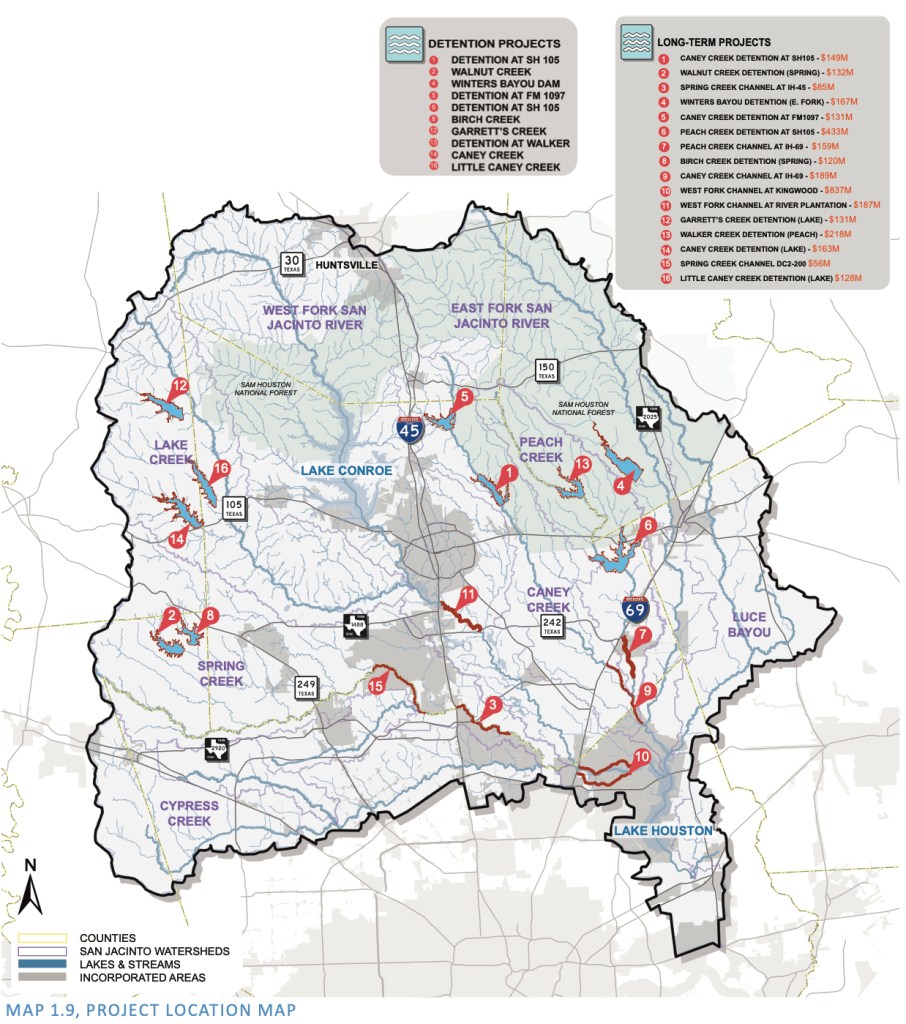
Location of MoCo projects in San Jacinto River Basin Master Drainage Study
Upper San Jacinto River Basin Sedimentation Study
This SJRA study is also an extension of work started in the San Jacinto River Basin Master Drainage Study. The application for this grant from the state’s Flood Infrastructure Fund states, “Any sedimentation reduction activity in the Upper San Jacinto River Basin (Lake Houston watershed) is anticipated to achieve some level of reduction of sediment load entering Lake Houston, which would in turn reduce storage reduction in the lake, which is the major water supply reservoir for the City of Houston and surrounding communities.”
It could also reduce Lake Houston Area dredging costs which Costello estimates will total $222 million. After taking years to dredge the West Fork, the City is now dredging its way to the East Fork.
Barrett has not yet selected a consultant for the sedimentation project. He hopes to get that started by Spring 2022. The Spring Creek and Joint Operations studies have much shorter timetables, so the SJRA started those first.
Potential vendors interested in developing a long-term dredging plan for Lake Houston had to submit their qualifications by September 23rd last week.
It’s not clear how many vendors responded or who they were. According to Stephen Costello, “It is my understanding that this information is not available due to the quiet period provisions of the city’s procurement process. The information will not be available until the consultant is selected/contract terms negotiated and the contract is on the city agenda for council action.”
That should happen sometime in November. Stay tuned.
Said Barrett, “The Caney Creek project is on hold due to limitations of the CDBG-MIT funding program. Grants for a single project were limited to $100 million in the first round of applications (and the reservoir project as recommended in the San Jacinto Regional Watershed Master Drainage Plan was anticipated to be over $100 million by a decent amount).”
The Texas General Land Office (GLO), which coordinates HUD grants in Texas is committing most of the 2nd round funding to HCFCD after the uproar that followed Harris County’s snub in the first round. Barrett says he is coordinating with appropriate entities to determine how that funding will ultimately be distributed and whether SJRA would be eligible to receive any.
The thoughts expressed in this post represent opinions on matters of public concern and safety. They are protected by the First Amendment of the US Constitution and the Anti-SLAPP Statute of the Great State of Texas.
https://i0.wp.com/reduceflooding.com/wp-content/uploads/2020/12/Project-Location-Map.jpg?fit=1238%2C1400&ssl=114001238adminadmin2021-09-30 19:04:282021-10-01 09:03:47Flood Mitigation Digest: Updates on Nine Lake Houston Area Efforts
Most of us have seen sinkholes. And most of us have probably given little thought to what causes them.
Retired engineer Chris Bloch, a local flood fighter, measured a 13-foot deep sinkhole near Taylor Gulley earlier this year that had become overgrown with vegetation. Working with the City of Houston and a local homeowner who first reported the problem, they found the sinkhole related to a nearby storm drain.
Bloch lowered this length of PVC pipe into the Taylor Gully sinkhole to measure the depth.Note how the hole had become overgrown with vegetation.
Other things can cause sinkholes, but in this area and in this part of the world, “storm drain gone bad” ranks high on the list of things to investigate.
Corrugated Pipe Commonly Used At Outfalls When Kingwood Built
According to Bloch, when Friendswood built Kingwood, they commonly used corrugated metal pipe (CMP) at storm sewer outfalls. CMP has an expected service life of approximately 35 years, says Bloch. And corrosion commonly causes failure at older outfalls constructed with such pipe.
For example, see the section of pipe below. This photo was taken on Ben’s Branch, not Taylor Gully, but it shows how the pipe rusted, bent, and crimped. Also look just to the right of the wooden posts, and you can even see a large hole in the pipe. It even tilts upward before it reaches the creek.
Bloch frequently walks ditches looking for sinkholes to report to the City. He says he’s aware of at least five right now.
The 72-inch outfall to Taylor Gully serviced drainage area G03408-00-OUT which encompasses all of Greenriver Valley Drive and Mountain Bluff Lane as well as portions of Appalachian Trail, Natural Bridge and Echo Falls Drives. That area comprises 33.4 acres. See below.
Service area for damaged outfall encompasses 33.4 acres where several homes flooded.
The transition from a 72-inch concrete storm sewer to the 72-inch CMP outfall is at a manhole on the edge of the Taylor Gully right of way. See below.
Over the years, the CMP at the connection to the manhole failed. The earth above the failed pipe washed into the outfall and then downstream where it helped reduce the conveyance of Taylor Gully.
Repairs Started But Not Complete
The City of Houston has already repaired several storm sewers with failed corrugated metal outfalls. At least five additional storm sewer outfalls with sinkholes have been identified that have not yet been repaired.
Vegetation frequently hides the presence of these sinkholes. In addition to posing a danger to citizens walking along the banks of the drainage channels, the soil that falls into the sewer can be held up by the corrugations of the metal pipe reducing the flow capacity of the sewer, says Bloch.
Even without obstruction from soil falling into a sewer outfall, the rough surface of the corrugated metal pipe generates greater friction than smooth concrete. The friction slows the flow of storm water and reduces flow capacity which becomes critical during high intensity rains that cause street flooding.
Bloch somehow convinced the City of Houston Public Works Department to replace the damaged CMP at Taylor Gully with concrete pipe. See below.
“This upgrade in the outfall piping will significantly improve the flow capacity of the storm sewer system,” says Bloch.
Concrete pipe replaced CMP at the location of the 13-foot sinkhole on Taylor Gully. Installed by City of Houston Public Works Departmentafter HCFCD repaired Gully.
Concrete Better for New Atlas-14 Rainfall Intensities
When Friendswood Development installed stormwater sewers in Kingwood, they met standards which applied at that time. With new Atlas-14 rainfall projections, we now understand that we should expect more rainfall. Several homes along Appalachian Trial suffered flood damage during Tropical Storm Imelda.
How to Report Sinkholes When You Find Them
As they say, it takes a village to reduce flooding. Now that you know the story behind sinkholes…
If you jog or walk along drainage ditches, exercise caution. Look out for developing sinkholes. And report them to 3-1-1 when you find them. They can pose dangers to children and even grown adults. To put that in perspective, Bloch (shown in the first photo) is more than 6 feet tall, but the sinkhole dwarfs him.
This NBC News story on YouTube has some spectacular examples of sinkholes in Florida along with easy to understand animations that show how they form.
Another 7 minute YouTube video from a series called Practical Engineering focuses on how sinkholes form. It contains both real world examples and table-top experiments that bring the processes to life.
Posted by Bob Rehak based on information and photos provided by Chris Bloch
1492 Days since Hurricane Harvey
https://i0.wp.com/reduceflooding.com/wp-content/uploads/2021/09/Sinkhole-Depth-2-scaled.jpg?fit=1920%2C2560&ssl=125601920adminadmin2021-09-29 16:40:182021-09-30 15:53:15Sinkholes Often Sign of Damaged Storm Drains
The City of Houston Planning Commission was to have considered plat approval on September 30th for redevelopment of the old Kingwood Cove Golf Course acquired by Ron Holley and his FLOG Partners. However, I learned late today from District E Councilman Dave Martin’s office that Planning Commission staff is recommending postponing the public hearing until at least the next regularly scheduled meeting on October 14th.
The Planning Department Staff met with Houston Public Works staff. Reportedly, the applicant has not yet provided all the information necessary for Publics Works to review the application.
Drainage Study Reportedly Not Detailed Enough
According to Martin’s office, Holley’s people submitted a drainage study for the Kingwood Cove development. However…
“Public Works indicated that it needed a more detailed analysis.”
Spokesperson for District E Council Member Dave Martin
Therefore, Planning Department Staff will reportedly recommend to the Planning Commission that Commissioners postpone the public hearing. This will likely happen in the meeting itself when the agenda item is called. But a delay is not automatically guaranteed.
As of this afternoon, approval of the Kingwood Cove plats was still on the agenda.
If Delayed, October 14 Next Possible Date
If the applicant were to provide all required information immediately so that staff could review and provide recommendations, the earliest date for reconsideration would be October 14th (the next meeting following September 30).
The Planning Commission posted Holley’s current plans in two places:
A 24-page abbreviated version as part of the agenda
I haven’t had time to review the entire set of plans yet, so I’m including them all here for you to review. However, I did note several items that may explain why Public Works raised questions.
No HCFCD Check Off Yet
Apparently, no one from Harris County Flood Control District (HCFCD) has reviewed or signed the drainage plans yet. Note how the signature blocks are empty.
Beat-the-Peak Method Employed in Flood Calculations
The Kingwood Cove engineers apparently used the beat-the-peak hydrologic-timing method to support their claim of “no adverse impact.” They also based their calculations on profiles developed from 2001 LIDAR data and a 2012 model of the river basin.
FEMA’s National Flood Hazard Layer Viewer indicates that the boundary of the floodway shown above dates to 2008. Harris County Flood Control’s MAAPNext effort, however, is revising the flood maps. Floodways all over the county are expanding into the 100-year floodplain. So some or all of this detention pond could soon find itself within the floodway.
No Adverse Impact?
The Kingwood Cove engineers claim the detention pond would protect downstream residents in a 500-year storm, but the Harris County Flood Warning System shows, the pond would be under 9.5 feet of water in a 10-year storm. And 22 feet of water in a 500-year storm! I fail to see how the pond would be holding anything back in such situations.
Photo taken from helicopter on June 16, 2020 shows area in middle where Kingwood Cove detention pond would go. Looking SW.
A Grandfathering Play?
Note that Halff engineers submitted their Kingwood Cove drainage analysis on March 17, 2021, and the City implemented its .65 acre feet of detention per acre on March 31, 2021. Holley is just now seeking approval.
If he’s expecting to get a pass because he submitted the plans before a change in regulations, I would submit that we saw how dangerous that can be in the case of Woodridge Village and Elm Grove. Woodridge Village engineers calculated detention requirements based on pre-Atlas 14 data and got it grandfathered by MoCo even though everyone knew the requirements were changing.
There’s certainly lots to think about in these plans. They deserve more close scrutiny.
The thoughts expressed in this post represent opinions on matters of public concern and safety. They are protected by the First Amendment of the US Constitution and the Anti-SLAPP Statute of the Great State of Texas.
https://i0.wp.com/reduceflooding.com/wp-content/uploads/2021/09/20200616-RJR_4514.jpg?fit=1200%2C800&ssl=18001200adminadmin2021-09-27 19:48:112021-09-28 20:01:34CoH Public Works Asking for More Details on Kingwood Cove Golf Course Conversion
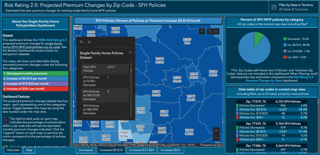
Starting Oct. 1, FEMA’s new Risk Rating 2.0 will fundamentally change the way FEMA rates a property’s flood risk and prices insurance premiums. But to what extent will that affect premium changes in your area?
To help answer that question, the American Society of Flood Plain Managers (ASFPM) and The Pew Charitable Trusts recently unveiled newinteractive maps. They show exactly where flood insurance premiums will decrease, increase, or remain the same — and by how much.
Risk Rating 2.0 incorporates more flood risk data to more accurately reflect a property’s individual flood risk. Types of data include:
Frequency and types of flooding (river overflow, storm surge, coastal erosion, heavy rainfall)
Distance to a water source
Property characteristics ( elevation, cost to rebuild).
Visual Tools Make Data More Accessible
ASFPM developed the interactive maps to help local leaders better communicate what’s occurring in their communities, but it’s also easy enough for an average person to grasp.
“There is a fair amount of information available on Risk Rating 2.0. But getting that data out of spreadsheets is challenging. This new tool should help,” said Chad Berginnis, ASFPM’s executive director.
“Floods are this nation’s most frequent and costly natural disasters. And the trends are worsening. It’s important that people know their risk and buy flood insurance to help protect their homes and businesses. It’s equally important that communities take steps to minimize flood risk,” said Berginnis.
ASFPM used datasets fromFEMA’s NFIP policyholder information to create the easy-to-use data visualization tool. The data are broken down across four categories. They range from a decrease in premiums to an increase of $20/month or more. A color-coded scale indicates the percentage of policyholders in each category.
Interactive Maps Show Premium Changes By State, Zip
The first interactive map at no.floods.org/rr2changes breaks down projected premium changes for each state and territory.
For all existing NFIP policies at no.floods.org/rr2all (residential, commercial, multi-family, etc.)
The data compares a snapshot of policyholder premiums from May 31, 2020 with Risk Rating 2.0 premiums, applying statutory increase limits.
The comparison does not attempt to estimate premium increases that might have occurred without the new Risk Rating 2.0 pricing methodology.
This data won’t tell you what will happen to your premiums. But it will give you a rough idea of the percentages of people in your zip code who can expect increases within certain pricing brackets. The brackets include:
Decreases
Increases in the $0 to $10/month range
Increases in the $10 to $20/month range
Increases in the $20+/month range
Zip Codes in Lake Houston Area
The maps for local zip codes showed that the vast majority of all local policies in the Lake Houston area will increase between $0 and $10 per month.
The vast majority of policies in the upper Lake Houston area will see monthly increases of less than $10.This includes homes and businesses.
Clicking on the other tabs at the bottom of the map will show you the percentage of policies that fall into other ranges.
Very few people in these zip codes will see decreases. Almost everyone else will see increases greater than $10 or $20/month.
Looking only at increases for Single-Family-Home policies, about 90% of policies should see a monthly increase in the $0-10 range.
The maps contain far more detail than shown above. When you click on a zip code, areas surrounding the map and within the black pop-up box, display the data in tabular and graphic formats. Make sure you scroll through the data in the black pop-up box. It breaks the highest and lowest categories down into far more brackets. For instance, the $20+ category actually includes brackets up to $90-$100/per month.
Individual policyholders should contact their insurance agent for a personalized quote.
Use this data for comparison purposes to make sure you’re not overpaying. But remember, variations such as your proximity to water, first floor elevation, and the replacement value of your home could skew results from the average in your zip code.
The largest increases in the Houston area will be in Pasadena’s 77507 zip code. More that 50% of the policy holders there will see a $20+/month increase.
First Pricing Update in 40 Years
This is the program’s first pricing update in more than 40 years.
“Under Risk Rating 2.0, FEMA is fixing longstanding inequities in the NFIP’s flood insurance pricing and establishing a system that is better equipped for the reality of frequent flooding caused by climate change,” said David Maurstad, senior executive of the National Flood Insurance Program. “Risk Rating 2.0 is not just a minor improvement, but a transformational leap forward that enables FEMA to set rates that are fairer and ensures rate increases and decreases are both equitable.”
According to FEMA, only 4% of policyholders nationwide are expected to see substantive increases. In a national rate analysis of current policyholders, FEMA has said:
23% will see premium decreases
66% will see, on average, premium increases of $0-$10/month (which is around what the average is now)
7% will see, on average, premium increases of $10-$20/month
4% will see, on average, premium increases of $20 or more per month.
Background on Risk Rating 2.0
Risk Rating 2.0 will deliver rates that are actuarially sound, equitable, easier to understand, and better reflect an individual property’s unique flood risk.
By communicating flood risk more clearly, the new methodology should help policyholders make more informed decisions on the purchase of adequate insurance and on mitigation actions to protect against flooding. FEMA is implementing the program in two phases:
Phase I – New policies beginning Oct. 1, 2021 are subject to the new pricing methodology. Also beginning October 1, existing policyholders are able to take advantage of immediate decreases in their premiums when the policy renews.
Phase II – Renewals of the remaining existing flood insurance policies will be written to the new plan starting April 1, 2022, allowing policyholders an additional six months to prepare for any adjustments.
Posted by Bob Rehak on 9/26/21 based on a press release from ASFPMprovided by Diane Cooper
1489 Days since Hurricane Harvey
https://i0.wp.com/reduceflooding.com/wp-content/uploads/2021/09/Screen-Shot-2021-09-26-at-3.02.09-PM.png?fit=1292%2C870&ssl=18701292adminadmin2021-09-26 16:10:042021-09-26 21:20:50New Interactive Maps Show Flood Insurance Premium Changes With Risk Rating 2.0
Today, at a meeting of the Harris County Flood Resilience Task Force, Vanessa Toro of the County Judge’s Office and Leah Chambers, Principal of consulting firm Outside Voices presented several slides about flooding and flood-mitigation efforts in Harris County that you might find interesting. Their presentation started with a series of slides that illuminated the history of flooding in Harris County; types of flooding; mitigation challenges, and mitigation efforts currently underway.
Historical Flooding and Mitigation
The first four slides address historical flooding and build on each other.
Selected historical milestones show dates and damage from several major storms in the last 20 years.
The next slide shows the major challenges in each epoch.
The third shows major mitigation efforts over time.
The dotted line shows spending by Harris County to help control flooding.
Different Types of Flooding Throughout County
The presentation then went into examples of the different types of flooding we experience. While river and bayou flooding are important to the Lake Houston Area, in other parts of the county, street flooding is a bigger issue. During high intensity rainfalls, water can’t get to the bayous.
Down in the southern part of the county, coastal flooding from storm surge is the main concern.
Each type of flooding requires different mitigation strategies.
For instance:
Flood professionals often address river- and bayou-flooding with detention ponds and channel widening.
Street flooding may require better maintenance of ditches, bigger storm drains and wider storm sewers.
Coastal flooding may require dikes and better building codes that elevate homes higher.
Key Challenges with Flood Mitigation
The presentation then segued into key challenges we face and how the county is trying to address them.
The first slide in this section discussed incomplete knowledge.
For instance, FEMA’s flood maps measure river, bayou, major channel and coastal flooding, but not street flooding, which is a major problem in the inner city. Hopefully, the next generation of flood maps (See MAAPNext) will help address that.
There’s a feeling that large scale infrastructure projects by themselves will not solve our flooding problems. Various groups within the county are looking at ways to supplement them. The engineer’s office is looking at subdivision drainage. Several other groups are collaborating to explore nature based solutions, flood proofing, and more.
The title of the slide above refers to difficulty of coordinating flood-control efforts across complex jurisdictional boundaries.
Different areas have different priorities, needs and timetables. No one understands that better than those who live near county lines. For instance, upstream counties often use lax regulation and enforcement as a way to entice developers – much to the detriment of those who live downstream.
Flood Resilience Efforts Now Underway
While the 2018 flood bond gets all the publicity, it’s certainly not the only Harris County effort underway to mitigate flooding. The slide below shows the variety of efforts.
They include:
The Community Flood Resilience Task Force, a group designed to give voice to communities in developing the next generation of flood mitigation efforts.
MAAPNext to update flood maps, incorporate the more data sources, and make flood-risk easier to understand.
Resilience Actions Inventory, an ongoing effort to catalog resilience initiatives, projects and programs throughout the county.
Infrastructure Resilience Team – an interdepartmental team planning resilience projects. It includes: Flood Control, Engineering, Community Services, Public Health, Emergency Management, and the Toll Road Authority.
New departments, such as the Office of Sustainability and the Deputy County Administrator for Resilience and Infrastructure.
The ongoing Capital Improvement and Maintenance budgets of HCFCD.
All these efforts may not mesh like the gears in a Swiss watch. At least not today. But it’s good to know that efforts are underway on more than one front.
Posted by Bob Rehak on 9/25/2021 based on information from the Harris County Judge’s Office
1788 Days since Hurricane Harvey
https://i0.wp.com/reduceflooding.com/wp-content/uploads/2021/09/CFRTF-Retreat-Slides-Subset_092521_Page_14.jpg?fit=1500%2C844&ssl=18441500adminadmin2021-09-25 18:20:002021-09-25 18:35:00Update on Harris County Flood Mitigation Efforts
Hurricane Nicholas likely affected the schedule with the twin needs to secure equipment and lower the lake.
Regardless, when I put up a drone today, I found good news. The dredging is now much closer to the east fork than the west.
Dredging has now reached homes in Royal Shores. Looking south toward FM1960and Lake Houston.
Looking east toward the East Fork. Dredging should break through in about another 1000 feet, the width of another six or seven homes.
Assuming the City can maintain a pace of 200 feet per week, that would put crews in the East Fork by the end of October.
Distance dredged in three weeks since last update on August 28th.
Looking west. At present, there appear to be two crews working. Note one still way out near the west fork, widening or deepening the channelnear where they started in mid-July.
This certainly is one of the most beautiful parts of Houston for those who can afford to live with the flood risk.
Proposals for Long-Range Dredging Plan Due Today
A damage map compiled shortly after Harvey showed that 1290 Harris County homes flooded in the East Fork watershed.
https://i0.wp.com/reduceflooding.com/wp-content/uploads/2021/09/20210923-DJI_0475-2.jpg?fit=1200%2C800&ssl=18001200adminadmin2021-09-23 16:39:092021-09-23 19:08:06Dredging Now Closer to East Fork Than West
Tuesday, City of Houston Mayor Sylvester Turner and Houston Housing and Community Development Director Tom McCasland got into a verbal brawl over alleged improprieties in the distribution of Harvey relief funds.
Houston Mayor Sylvester Turner photographed in February of 2020.
The Mayor overrode the recommendations of McCasland and his staff, who pointed out that $16.2 million could have created four times the number of affordable units in poorer neighborhoods. Those projects all scored higher in the competition for funding.
General Land Office Response
Brittany Eck, a spokesperson for the Texas General Land Office (GLO), issued a statement within hours. She said, “The GLO is looking into the serious allegations of fraud or corruption regarding projects by the City of Houston’s Harvey Multifamily Program. The GLO is responsible for ensuring all money allocated through the Community Development Block Grants for Disaster Recovery (CDBG-DR) are spent appropriately. These projects and funds are intended to be utilized to aid the greatest number of low-income Texans as possible.”
Eck continued: “As such, we will re-review all requests for funding draws allocated to the City of Houston by the U.S. Department of Housing and Urban Development (HUD). The GLO will coordinate with HUD and other investigative entities to determine what actions should follow regarding these allegations. Fraud has no place in helping Texans recover from disaster.”
She concluded, “Anyone with information relating to potential fraud, waste, and/or abuse is encouraged to report it by calling 1-844-893-8937 or emailing cdr@recovery.texas.gov.”
Mayor’s Response
According to multiple news reports and a press release from the Mayor’s Office, Turner denied specific knowledge of the deal with his former law partner. He claimed there was no impropriety, that McCasland had raised no objections to the deal, and that he (Turner) had the right as Mayor to override McCasland’s objections.
The Mayor also asserted he was trying “to place affordable housing projects throughout the City…” Finally, he claimed he severed all ties with his former law partner before assuming his position as Mayor.
McCasland’s Point of View
McCasland insisted this was not the first time the Mayor’s office interfered. The Houston Chronicle, which broke the story, said “McCasland acknowledged the Mayor has the authority to overturn staff recommendations, but McCasland argued that in this case it represented a subversion of a competitive process to benefit one applicant.
McCasland said he was not alleging fraud, but said the pattern of behavior was emblematic of a broader problem in Turner’s administration, a “do-it-because-I-said-so” management style. McCasland did say that drives out public servants dedicated to integrity and breeds a “culture for corruption.”
Further, the Chronicle article quoted McCasland as saying he briefed the Mayor August 17 and again on August 24.
McCasland said the Clear Lake complex (Huntington at Bay Area) ranked 8th out of 12 proposals, and had the lowest percentage (60%) of its units reserved for low income tenants.
Note McCasland’s comments on page 4. He claims “The outcome of that process was predetermined before the funding opportunity was even issued.”
If you don’t read anything else, skip to the last page. It’s an email from McCasland to the Mayor dated September 17. In it, he summarizes all his objections to the Clear Lake deal. That would seem to contradict the Mayor’s claim that McCasland did not register his objections.
Mayor Fires McCasland
McCasland said to City Council, “I am being forced to participate in a charade that this was a competitive process, when I know it was not a competitive process. That’s the problem here and I’m being forced to ask my teammates to participate in that charade and that is not something that we can do and that is not something that we will do.”
According to those who watched the gripping testimony in City Council, it was like watching someone commit career suicide. By the end of the day, the Mayor issued a terse press release. He denied McCasland’s allegations, said he had lost confidence in McCasland, and that it was time to move on.
Why All of a Sudden?
The big question is this: Why now? McCasland and his embattled department have been under fire for years:
Coming forward when he did – as he did – almost felt like a Law & Order episode in which the DA flipped a witness with a promise of immunity. Some veteran City Hall observers felt McCasland was being unusually frank and fearless for someone at the center of such a huge mess. If there was a pattern of ethics violations, why wait years before objecting to them?
Mayor Likely Overstepped Authority
Both McCasland and the Mayor said the Mayor had the right to overturn staff decisions. But Eck pointed out the Mayor did not have the power to “rewrite” the Notice of Funding Availability (NOFA) to favor one applicant; any project selected must meet federal regulations.
She said that had the City written the NOFA to favor affluent neighborhoods, and had HUD and the GLO approved it that way, there would be no problem at this point. However, the City did not do that.
From McCasland’s report and the documentation provided, it appears the City’s award went against the scoring system laid out in the published NOFA, resulting in a competition that was not full, fair and open. The result led applicants to believe their projects would be considered against one criterion when other unknown criteria were actually utilized.
We now know the City awarded the project to a former partner of the Mayor in a high-income area…ignoring the posted and approved scoring system. In that regard, the Mayor evidently overstepped his authority.
The GLO has been in touch with HUD, the Texas Department of Housing and Community Affairs, Gov. Greg Abbott’s office and the Department of Public Safety, according to Eck.
KTRK’s Ted Oberg said DPS would only be involved to investigate criminal matters.
Brown, who audits City projects, continued, “In the past several months alone, our office has been denied procurement documents required to conduct an audit of the Strategic Procurement Department and were told to stop all work on a financial transparency project that would bring much-needed insight into the city’s spending practices. Taxpayers deserve a city government that is transparent and above reproach. Unfortunately, recent events suggest that the city is falling short of that goal.”
Posted by Bob Rehak on 9/22/2021
1485 Days since Hurricane Harvey
The thoughts expressed in this post represent opinions on matters of public concern and safety. They are protected by the First Amendment of the US Constitution and the Anti-SLAPP Statute of the Great State of Texas.
https://i0.wp.com/reduceflooding.com/wp-content/uploads/2020/02/20191017-RJR_3755.jpg?fit=1200%2C800&ssl=18001200adminadmin2021-09-22 22:05:092021-09-23 11:27:43Blowup Between Mayor and Housing Director Triggers Fraud Investigation over Harvey Funds