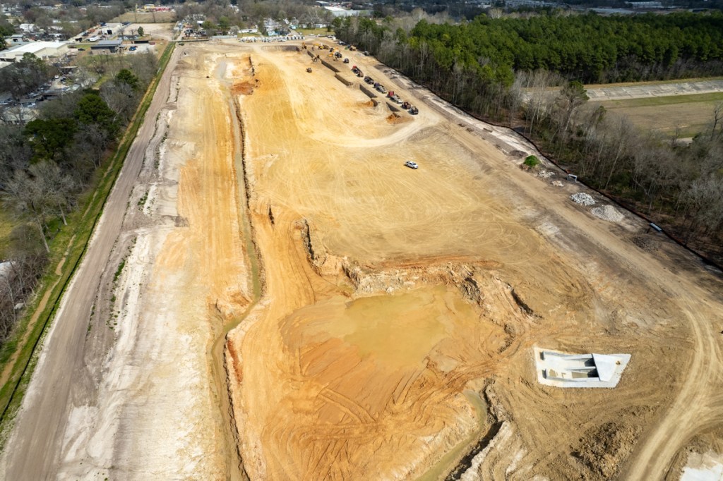
Along Halls Bayou, HCFCD is constructing a large stormwater detention basin and making channel conveyance improvements as part of Bond Project C-25. The detention basin will reduce the risk of flooding by taking in excess stormwater during heavy rain events and then releasing it slowly back to the channel when the threat of flooding has passed.
Looking S across Isom Street toward Halls Bayou at far end of detention pond.Photo Taken 3/5/22.Reverse shot. Looking N from over Halls Bayou. Photo taken 3/5/22.At the south end of the detention basin, before Halls Bayou comes out of its banks, water will pour over the wide concrete spillway and fill up the pond. As the level of water in Halls falls, water will go back into the bayou through the twin culverts.
Projected Completion Dates
HCFCD expects to complete construction of the stormwater detention basin during spring 2022 and channel conveyance improvements during fall 2022.
The $6 million stormwater detention basin project (P518-11-00) will provide regional mitigation benefits and also mitigate increased stormwater coming from drainage improvements in the Western Homes subdivision along Aldine Mail Route Road.
The basin will hold 180 acre-feet, or nearly 58.7 million gallons, of stormwater that might otherwise flood homes and businesses. It will be a wet-bottom basin with a vegetated shelf.
Channel Improvement Highlights
North of the basin, HCFCD will shift Tributary P118-21-00 west and enlarge it to increase its capacity. Along Aldine Mail Route Road and north of the road, the channel will be extended as a box culvert system to the Western Homes subdivision. The channel will have a 140-foot top width and 15-foot depth.
Looking east from the south side of the West Fork of the San Jacinto during Harvey. Photo courtesy of Harris County Flood Control District.
Unequal Impact of Mental Health Challenges
Section TS.B.5.2 says, “Mental health challenges increase with warming temperatures (high confidence), trauma associated with extreme weather (very high confidence), and loss of livelihoods and culture (high confidence). Distress sufficient to impair mental health has been caused by climate-related ecological grief associated with environmental change (e.g. solastalgia)…” [Emphasis added.]
The section continues, “Vulnerability to mental health effects of climate change varies by region and population, with evidence that Indigenous Peoples, agricultural communities, first responders, women, and members of minority groups experience greater impacts (high confidence).”
What Does Solastalgia Mean?
I’d never seen the word “solastalgia” before and had to look it up. It was difficult. Websters Third International Dictionary didn’t have it. The 20-volume Oxford English Dictionary didn’t have it either. But Wikipedia did have a discussion of it. It’s a neologism – a new word entering the language.
According to Wikipedia, “solastalgia” was coined by philosopher Glenn Albrecht in his 2003 book Solastalgia: a new concept in human health and identity.[1] He describes it as “the homesickness you have when you are still at home” and your home environment is changing in ways you find distressing. In many cases, this relates to climate change, but more localized events such as volcanic eruptions, drought or destructive mining techniques can cause solastalgia as well.[2]
Solastalgia refers to the “distress specifically caused by environmental change while still in a home environment.”[3]
You like the serenity of living near water. Then Harvey floods your home without warning in the middle of the night and you narrowly escape with your life.
Solastalgia literally means “loss of solace.” Solace, in turn, means “comfort or consolation in a time of distress.” For instance, after the death of parent, you might seek solace by returning to the place where you grew up. But when you get there, you find a strip mine has obliterated the entire area. Now your grief doubles and you feel “solastalgia,” the loss of solace.
Distress Related to Income Level
Solastalgia affects people differently. Some groups are inherently more vulnerable and, therefore, may experience a greater sense of loss and grief. This study from a group of scholars at UCLA examined the impact of wildfires on psychological well-being.
They found a marked difference in the way high- and low-income groups processed loss. Those making more than $80,000 a year had resources to rebuild and experienced less grief. Those making less felt lost. The adverse financial impact of a fire felt insurmountable and left them with “clinically significant psychological distress.”
Those who lived in Houston during Hurricane Harvey can relate to this. Many are still trying to find the help to rebuild their homes and lives. The lucky ones moved on. Others still live among mold and rot, constant reminders of the day their lives changed forever.
I previously talked about flood psychology in terms of post traumatic stress disorder and re-traumatization. But I think solastalgia fits what I see better. Even 4.5 years after the flood. What do you think?
Posted by Bob Rehak on 3/4/22
1648 Days after Hurricane Harvey
https://i0.wp.com/reduceflooding.com/wp-content/uploads/2018/07/HumbleFloodFromHCFCD-e1761946748900.jpg?fit=1100%2C821&ssl=18211100adminadmin2022-03-04 15:29:222022-03-04 15:42:28Word of the Day for Flood Victims: Solastalgia
Four months after Laurel Springs RV Resort contractors started tying into the Lakewood Cove storm sewer system, they may finally finish the job in the next few days. I spotted them yesterday and today, digging a trench from the pumps to the pond.
At their present rate of progress, and with gasoline prices spiraling out of control, one wonders whether RVs will be able to afford gas to get here when this job is complete.
Detention Pond Storm Sewer Tie In Started in Early December
Laurel Springs RV Resort detention pond drainage tie in as of 12/05/21. Contractor has tunneled under Laurel Springs Lane to Lakewood Cove storm sewer system on far side.Drainage plans approved by City of Houston for this portion of the job site. SE corner of detention pond below is in upper leftof diagram above.
Contractor Now Working on Approved Tie In
Wednesday around noon, 3/02/22, workers started excavating around the circular pump housing. By early morning 3/3/22, they had already laid the first section of pipe.By noon on 3/3/22, they had laid another section of pipe and were excavating their way to the corner of the pond.
Rec Center Being Framed Out
In separate news, workers started framing the RV Resort recreation building yesterday.
This shows the status on the morning of 3/3/22.
Spiraling Cost of Gasoline Could Affect Demand
I heard a story on the radio this morning that gasoline in Toronto has now topped $8.50 USD per gallon. With gasoline prices spiraling out of control, it’s unclear how many people will be traveling in RVs anytime soon. The larger ones get as little as 6 miles per gallon.
I remember taking a trip through the Yukon Territory several years ago when gasoline was half that price and seeing an RV fill up for more than $1000.
That’s comparable to the cost of a 2500 square-foot penthouse suite in a luxury 5-star hotel.
Now imagine doubling that cost to stay in something one tenth the size.
As they say in Hollywood, “Timing is everything in show business.” You could say the same for the RV park business.
Posted by Bob Rehak on 3/3/22
1647 Days since Hurricane Harvey
The thoughts expressed in this post represent opinions on matters of public concern and safety. They are protected by the First Amendment of the US Constitution and the Anti-SLAPP Statute of the Great State of Texas.
https://i0.wp.com/reduceflooding.com/wp-content/uploads/2022/03/20220303-DJI_0535.jpg?fit=1200%2C799&ssl=17991200adminadmin2022-03-03 15:16:502022-03-03 15:31:20RV Resort Detention-Pond Drain Finally Being Installed in Approved Location
Within the last week, the focus of dredging moved from the East Fork San Jacinto to the mouth of Rogers Gully on the west side of Lake Houston near the Walden Country Club. HCFCD conducted a dredging operation upstream from the Rogers Gully mouth bar in 2020. But the mouth bar itself is in Lake Houston, which is owned by the City of Houston. So this portion is the City’s responsibility.
Where dredging stopped in East Fork in late February. Looking South. Luce Bayou on upper left. FM1960 Bridge in upper right.Picture taken 2/27/22.Rogers Gully mouth bar has already been partially removed by the dredgers anchored in the distance for the evening.Looking east toward Huffman on far side of lake from over the Walden Country Club.Photo taken 3/1/22.
New Base of Operations Will Shorten Supply Lines
At the same time, the base of operations for dredging appears to be moving from the West Fork to a marina across the lake from Rogers Gully. The new drop off point for spoils is about 2.2 miles from Rogers Gully. Compare that to almost 7 miles to get from the East Fork to Berry Madden’s property south of River Grove Park on the West Fork.
New deposit site for dredging spoils on Fairlake Lane in Huffman.Photo taken 2/27/22.
Over the weekend, I photographed dredgers preparing the site and carting the first loads of sediment to a dirt/mulch company about six miles east on 1960.
Where spoils from Lake Houston are going on FM1960 toward 99.
The dirt company is about 2 miles inside the new Grand Parkway extension.
Looking south. New Grand Parkway extension crossing FM1960. Photo taken 2/27/22.
The new highway will open vast new areas for development and create ready markets for dredging spoils to elevate homes and build roads.
Focus Shifting to Inlets Around Lake
According to State Representative Dan Huberty, about $40 million remains in the dredging fund appropriated by the state legislature last year. He hopes that after inlets around the lake are cleaned out, that dredgers will return to the East Fork in the future to continue the effort there.
Pictures taken this afternoon show that in the last two days, the dredgers have taken a significant bite out of the Rogers Gully mouth bar, which in my opinion, was the worst of many smaller inlets around the lake.
Rogers Gully mouth bar in August of 2020. Compare to photos below to see progress already made.
The photos below tell the story.
Looking west from beyond one of the anchored dredges toward the mouth bar and the Walden Country Club in the top center.Still looking west at the partially removed mouth bar.Looking NNW.From here, tugs will ferry the pontoons toward the general vicinity of that white spot on the lake front in the upper right.Note the FM1960 bridge in the background.
Soon, the dredgers will finish with Rogers Gully and move on to the next inlet.
Posted by Bob Rehak on 3/1/22 with input from Dan Huberty
1645 Days since Hurricane Harvey
https://i0.wp.com/reduceflooding.com/wp-content/uploads/2022/03/20220301-DJI_0429.jpg?fit=1200%2C799&ssl=17991200adminadmin2022-03-01 19:01:142022-03-01 19:09:52Dredgers Move to Rogers Gully from East Fork
Since development of the Laurel Springs RV Resort started last October, the Centerpoint easement below the development has turned into a small lake. It’s not clear at this point what caused the lake to develop. Several theories come time mind: increased runoff; sediment blocking drains; heavy January rains; poorly drained soils; illegal discharges; or some combination of the above. Regardless, this raises the most common question I encounter these days. “What happens when a developer builds its land up and sends water onto my property?”
Before Development
Here’s how the Centerpoint easement looked on October 25 last year when contractors started clearing land. Note the power lines in the small corridor left of the bigger one for railroad tracks. Also notice the tiny little ponds in the distance toward Hamblen Road at the top of the frame.
Looking SSE along the utility corridor and railroad tracks to the west of the RV resort shortly after clearing started on October 25, 2021.
According to Weather.gov, the 30 year average for October is 5.46 inches. So we got a little more than an inch above normal. Yet the corridor had only tiny amounts of ponding water.
January Photo Shows Ponds Expanding
On January 9, we had a large rainfall event and a photo that day shows the ponds expanded.
After heavy rains on 1/9/2022. Note small stream of water running down middle of utility corridor and two large ponds.
But also note how the larger pond in the distance stops well short of Hamblen Road in top right of frame.
February Rainfall One Third of Normal, But Ponds Continue to Grow
But since January 8/9, we’ve had very little rain. Nevertheless, the ponds have expanded into what one resident called a “lake” that blocked her hike down the utility corridor. See below.
Looking S toward Hamblen Road at top of frame. Pond now extends almost all the way to Hamblen.
The amazing thing is that the “lake” grew despite very little rain in February. As the chart below shows, we got 1 inch which is one third of the monthly average of 2.97 inches. Moreover, we got no significant rain for the 7 weeks before I took the picture above.
Yet the lake now stretches almost all the way to Hamblen! It’s getting bigger! So where’s the water coming from?
Water Not Coming West, East or South
It didn’t come from west of the railroad tracks. Union Pacific elevated those several feet above ground level.
Laurel Springs Lane has storm sewers that would have intercepted water from the east.
And water doesn’t usually flow uphill, so it didn’t come from the south either.
Much of it probably came from the north and the detention pond below which the developers drained into Edgewater Park on January 29.
Contractors drained detention pond into Edgewater Park on January 29.
Prior to that, they also pumped water over the wall of the pond.
Laurel Springs RV Resort pumping stormwater into Edgewater Parkon 1/18/2022.Then on January 31, contractors even tried to lay pipe through the wall of the detention pond to create a permanent conduit for stormwater into Edgewater Park.
Addition of Fill
They’re also bringing in fill to build up the RV Resort higher than the property around them. As they do so, they have been pushing standing water toward the utility corridor.
Looking west toward Centerpoint corridor just beyond tree line. Photo taken 2/10/22.
Lake Expands on One-Third Average Rainfall!
The bottom line is this.
Standing water in the Centerpoint utility corridor has increased as rainfall has fallen well below normal.
When you look around, there’s only one place this water could have come from.
I don’t want to beat this horse to death. But I get emails every day from people across northern Harris and southern Montgomery Counties. They worry about comparable issues. In essence, the emails say something like this: “A developer is building up land and flooding my property.”
I can understand the desire to build up land to avoid flooding on your own property. But we need to agree on ways to avoid flooding neighbors in the process. The answer probably lies in:
Better construction practices and training, i.e., sloping all land toward detention ponds.
Meaningful inspections and penalties by authorities.
Publication of the penalties.
Posted by Bob Rehak on 2/28/2022
1644 Days since Hurricane Harvey
The thoughts expressed in this post represent opinions on matters of public concern and safety. They are protected by the First Amendment of the US Constitution and the Anti-SLAPP Statute of the Great State of Texas.
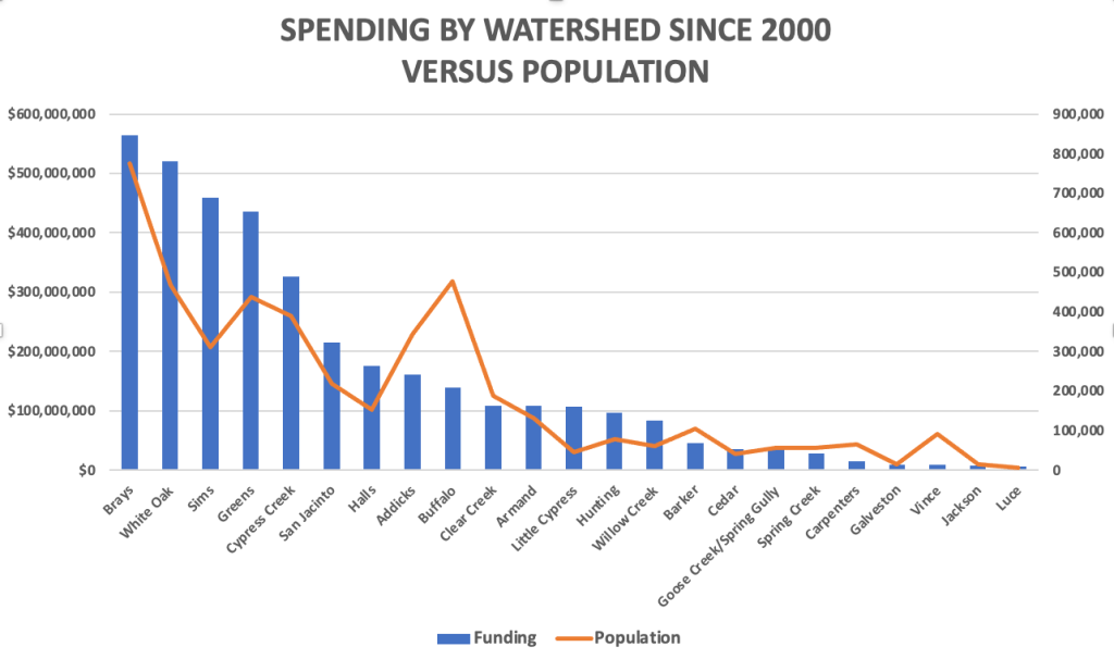
New data obtained from Harris County Flood Control District via a FOIA Request breaks down flood-mitigation funding by watershed through the end of 2021. It shows where your flood-bond money is going. It also debunks some popular myths. Those include the oft repeated:
Rich watersheds get all the funding; poor watersheds get none.
Partner funding favors rich watersheds because home values are higher.
HCFCD has historically discriminated against low-to-moderate income (LMI) watersheds.
Eight out of 23 watersheds in Harris County have a majority of residents that fall into the LMI category. That means a majority make less than the average annual income for the region. As the data below shows, those eight LMI watersheds get the vast majority of county, partner, and total funding. In fact, four have received 54% of total flood-mitigation funding since 2000.
Funding now correlates more highly with LMI population than damage!
Before I dive into the data, though, let me point out that between the 3Q21 and the end of last year, the county changed the way it compiles historical data. Instead of using the start/stop dates in project management software and reporting only completed projects, the county is now using invoice dates. This produces much higher accuracy. Dollars do not spill over from one period into another. The new data also reflects spending on projects that are ongoing, but still open.
In response to my FOIA Request, the county provided spending using both the old and new methods. They differ by roughly $615 million. Of that, approximately $215 million reflects actual fourth-quarter spending and $400 million reflects the change in when expenses are recognized.
Spending by Watershed
The rank order of spending by watershed has not changed much since last year. Several watersheds moved up or down by a place or two.
The top four are still the top four in the same order. But some of the amounts changed radically, mostly due to the change accounting. For instance, White Oak increased from $387 million to $521 million. But out of the $134 million difference, $102 million comes from when expenses are recognized.
Because this gets so confusing, and because the rank order did not change much, I will use only the new totals compiled by invoice date from now on. I will not compare old and new totals based on the different accounting methods.
Spending by watershed between 1/1/2000 and 12/31/2121 broken down by county and partner contributions, and LMI/Other watersheds.
Graphs of Spending
Here’s a graph of total funding by watershed since 2000, arranged from highest to lowest.
Watersheds rank ordered by amount of flood-mitigation funding received between 1/1/2000 and 12/31/2121.
Funding correlates with population. But you can see notable exceptions below. Some watersheds get far more funding than their proportion of the population, i.e., White Oak, Sims and Greens. Others get far less.
Spending is not allocated proportionately to population in all cases. Six out of eight LMI watersheds received more funding than their population alone would justify.
But population alone does not tell the whole story. Some watersheds are huge and some small. So I also looked at population density per square mile. The curves correlated even less.
Graphing population density vs. total spending shows more variance. Of the eight LMI watersheds, four (Brays, White Oak, Sims, and Greens) get far more than their population density alone would dictate.
As we saw last year, funding flows primarily to damage. The chart below plots funding versus the total number of structures in each watershed damaged in five major storms (Allison, Tax Day, Memorial Day, Harvey, and Imelda). The slope of the curves closely match. But several major exceptions exist.
Historical Discrimination?
Many community groups from LMI neighborhoods have alleged historical discrimination in the distribution of flood-mitigation funding. I just don’t see it. All of the pie charts below take into account all funding between 1/1/2000 and 12/31/2021 based on invoice dates.
The county itself sent almost 60% of its flood-mitigation funding to one third of the watershedswith majority LMI populations.An even larger percentage came from partner funding.Whether you look only at county funding, partner-funding, or the total, the picture is still roughly the same.One third of the watersheds get almost two thirds of the funding.Top 4 include Brays, White Oak, Sims and Greens. All have an LMI percentage higher than 50%.
LMI Population Now Correlates Higher with Funding than Damage
A coefficient of correlation of 1.0 is considered perfect. A good example: between gallons of gas in your car and the distance they will take you.
As a result of the constant tweaking of the equity funding formula, “Population” and “LMI Population” now correlate more highly with “Funding” than “Damage.” The correlation between “Funding since 2000” and:
Population Density = .54
Damage = .85
Population = .87
LMI Population = .89
Statisticians consider all of the last three very high.
Despite investigations by local, county and state authorities into construction practices at the Laurel Springs RV Resort near Lakewood Cove, contractors seem to have stepped up the pace of construction. They’ve also launched a major cleanup effort around the detention pond. Contractors triggered a cease-and-desist letter from the County Attorney, with the threat of a lawsuit, after it became apparent the developer was emptying its stormwater into Harris County Precinct 4’s Edgewater Park contrary to permits and approved plans. Contractors also apparently cut down a wide swath of trees in the northern part of the park.
Photos Showing Construction Activity Since Last Friday
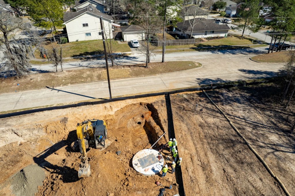
Looking west toward Sorters-McClellan Bridge over 59. Edgewater Park on left. RV Resort on right. Silt fence at the base of the pond corresponds to approximate southern boundary of RV Resort on survey. Taken 2/24/22.Looking south along Laurel Springs Lane at freshly poured concrete at entrance. Taken 2/24.This afternoon (2/25), trucks were pouring more concrete.Pipes being laid in northern part of RV Resort.Note water still ponding from rain in early January. Soil reports in the site’s stormwater pollution prevention plan claimed the soil was sandy loam which would have absorbed the rain by now.Still no pipe from the corner of the detention pond leading to the pump housing in the round whiteconcrete housing at top of frame. 2/23/22.
The detention pond was to have drained into the Lakewood Cove storm sewer system with the aid of pumps. But there’s no inlet yet at the pond.
Looking east toward Laurel Springs on 2/19/22.Plans approved by City of Houston for pumping stormwater in detention pond into Lakewood Cove’s storm sewer system.Contractors pulling up tree debris from below detention pond. 2/18/22.Looking SW.Looking south toward Edgewater Park. Contractors initially piled the debris on the western (right) wall of detention pond, but ran out of room. They then started hauling it round to northern edge of pond where trucks are carting it away.
Overall, the developer appears to be cleaning up its act. But as you can see in the first shot, they seem to have made a significant and serious intrusion on Edgewater Park.
Posted by Bob Rehak on 2/25/22
1641 Days since Hurricane Harvey
The thoughts expressed in this post represent opinions on matters of public concern and safety. They are protected by the First Amendment of the US Constitution and the Anti-SLAPP Statute of the Great State of Texas.
Several readers recently asked for a an update on the demolition of the remaining Forest Cove townhomes on Marina Drive. Three clusters remain near the Forest Cove Community Center. The vacant townhomes destroyed by Hurricane Harvey have become magnets for gangs, graffiti, dope dealing and illegal dumping. The people who wrote me avoid using the community center facilities because they now fear the area.
Difficulty and Delays with Demolition
Harvey flooded these once-proud buildings to the third floor. The flood swept some buildings off their foundations and rendered everything else structurally unsound. Harris County Flood Control District (HCFCD) has tried to buy out the properties ever since. However, they can’t tear down a building until all units within it have been purchased.
Most of the buildings have been torn down, burned down or swept away at this point. But HCFCD can’t find all owners. Several just moved away after Harvey and abandoned their property. That has stymied demolition efforts.
One Complex Scheduled for Demolition Soon
HCFCD’s property acquisition manager offered this update on the schedule for demolition.
Three buildings remain to demolish (1106, 1110 and 1020 Marina Drive).
1106 Marina Dr. is scheduled to be demolished within the next few weeks. That’s the building directly across Marina from the Community Center.
Two Still in Condemnation Proceedings
1110 and 1020 Marina Dr. will be demolished once the last 2 units are purchased (one in each building). These units are currently in condemnation proceedings.
Of the three remaining complexes, the one in the middle will soon come down. One owner couldn’t be found in this building. It is currently going through condemnation proceedings.One owner couldn’t be found in the building on the right. It is also going through condemnation proceedings.Not much remains. Someone could easily get killed or injured by stepping in the wrong place. Red area censored.Even the graffiti look terrified.What 240,000 cubic feet per second can do to your dream home with a close-up water view.
HCFCD also plans to clean up debris at the former location of 980 Aqua Vista in the near future. When HCFCD demolished that building earlier contractors left some materials behind.
Turning a Negative into a Positive
When HCFCD does finish demolishing these buildings, their long-range plan is to revert these properties back to nature and green space. That could turn what has become a blight on the community into an asset that supports the values of properties on higher ground.
Another good thing may come out of this. The destruction you see here may deter others from building these types of structures this close to a major river. Or even cause a change in building codes.
The theory here was that only garages would be built on the ground floor; living spaces would go safely above. That didn’t work out so well for the Forest Cove townhomes and those who invested their life savings.
Posted by Bob Rehak on 2/24/2022 with input from HCFCD
How soon we forget. Hurricane Harvey was just 4.5 years ago. Since then I have documented dozens, if not hundreds of questionable practices that erode margins of flood safety.
It Didn’t Have to Be That Bad
Harvey was the largest rainfall event in the history of North America. However, with better regulations and construction practices, it didn’t have to be as destructive as it was.
Lax regulations;
Willful blindness;
Development and construction practices that pushed the safety envelope;
Relentless destruction of forests and wetlands near rivers and streams;
And homebuyers who didn’t realize their true flood risk…
…made Harvey’s destruction worse than it otherwise would have been.
No one factor by itself would explain Harvey’s destruction. But put them all together, and it’s like “death of a thousand cuts.”
The sheer volume of material – more than 1,000,000 words on this site – makes it difficult for people to see the big picture sometimes. To put 1,000,000 words into perspective, the average novel contains only about 100,000. So I’m condensing the website into a book that includes the themes below.
No One Wins Arguments with Mother Nature
During an interview with Milan Saunders and his daughter Lori, Milan said, “No one wins arguments with Mother Nature.” How profound! It doesn’t matter how many surveys, studies and engineer stamps you have on your home’s title. If you don’t:
Large islands built up during Harvey blocked both drainage ditches and rivers. Below, you can see a large sand island (top) built up at the confluence of the Kingwood Diversion Ditch where it reaches the San Jacinto West Fork at River Grove Park. This sand bar reached 10-12 feet in height above the waterline and helped back water up into Trailwood, the Barrington and Kingwood Lakes and Kings Forest. Before the Army Corps dredged this island, River Grove flooded five times in six months. It hasn’t flooded since.
The Kingwood Diversion Ditch and West Fork San Jacinto were almost totally blocked by sediment dams deposited during Harvey.
The second photo above was taken a few hundred yards downstream on the West Fork from the first. It shows “Sand Island” – so nicknamed by the Army Corps. It took the Corps months to dredge this island which they say had blocked the West Fork by 90%.
A certain amount of this sedimentation can be explained by natural erosion. But mankind also contributed to the sheer volume by other practices which I will discuss below.
Influence of sand mines of West Fork San Jacinto water quality.
End the War on Wetlands
Wetlands are nature’s detention ponds. During storms, they hold water back so it won’t flood people downstream. But we seem to want to eradicate wetlands. The images below show the Colony Ridge development in Liberty County. Wetlands (right) are being cleared (left) to make way for the world’s largest trailer park. The acceleration of runoff wiped out FM1010 during Harvey. The road still has not been repaired.
Colony Ridge in Liberty County.
Conservation Costs Much Less than Mitigation
Halls Bayou at I-69 near Fiesta. Image on left shows whole subdivisions that that to be bought out before detention ponds on right could be built.
Respecting Individuals’ Property Rights While Protecting Others’
In Texas, it sometimes feels that an individual’s right to do what he/she wants with property trumps others’ rights NOT to flood. You may think you’re protected by all those public servants reviewing and approving plans. But what happens when developers and contractors decide to ignore the approved plans? Here’s a prime example: the Laurel Springs RV Resort near Lakewood Cove.
About 10% of all the water coming down the West Fork at the peak of Harvey came from Crystal Creek in Montgomery County. But the wetlands near the headwaters of Crystal Creek are currently under development. And the developer is avoiding building detention ponds with a “beat-the-peak” survey. This loophole allowed by Montgomery County says that if you get your stormwater to the river faster than the peak of a flood arrives, then you’re not adding to the peak of a flood and you don’t have to build detention ponds. So developers conduct timing surveys to reduce costs and maximize salable land.
What happens when upstream areas develop without consideration for the impact on downstream property owners.
Of course, speeding up the flow of water in a flood is the opposite of what you want to do. To reduce flooding, you should hold back as much water as possible.
The graph on the right shows what happened on Brays Bayou without suitable detention upstream. Floodwaters peak higher, sooner. Harris County has spent more than $700 million in the last 20 years to remediate flooding problems along Brays.
How much will we need to spend when more areas like Mavera get built upstream on the West Fork?
How Quickly We Forget!
FEMA’s Base-Flood-Elevation Viewer shows that in that same area, developers have already built homes that could go under 1-5 feet of water in a 100-year flood. These homes are actually in a ten-year flood zone. And yet more homes are being built nearby. On even more marginal land!
In recent years, the price of land as a percent of a new home’s cost has risen from a historical average of 25% to approximately 40% today. This puts pressure on developers to seek out cheaper land in floodplains, reduce costs by avoiding detention pond requirements, pave over wetlands, and reduce lot sizes resulting in more impervious cover. All contribute to flooding.
Of course, smart homebuyers would not make such risky investments. But few lack the expertise to gauge flood risk. Educating such homebuyers will be one of the major objectives of the book I hope to write.
Posted by Bob Rehak on 2/23/2022
1639 Days since Hurricane Harvey
The thoughts expressed in this post represent opinions on matters of public concern and safety. They are protected by the First Amendment of the US Constitution and the Anti-SLAPP Statute of the Great State of Texas.
https://i0.wp.com/reduceflooding.com/wp-content/uploads/2019/11/RJR_4245.jpg?fit=1500%2C1000&ssl=110001500adminadmin2022-02-23 18:55:302025-08-19 22:13:53How Soon We Forget!
Taxpayers like such contracts. But they have one potential drawback. If the market softens, it could take years to remove all the material. Progress to date has been slow, but steady.
Extent of removal on 2/14/22.Three days later, on 2/17/22.One day later on 2/18/22.
Harris County Flood Control executives emphasized that E&R contracts provide flexibility to both sides. They let Sprint move the material when it’s needed. And they let the Flood Control District get a head start on construction of detention ponds that they know they will need.
Perry left the Woodridge Village site 40% short of Atlas-14 requirements for detention-pond capacity. Five-hundred-thousand cubic yards will virtually double the detention-pond capacity, leaving a significant margin to help accommodate future upstream development.
HCFCD currently has no plans to tie this detention pond into the network of five others on the Woodridge site. It will just form a barrier against sheet flow from the north for the moment. Tie-ins with the existing drainage network could come after completion of the Taylor Gully engineering study.
After completion of the study, when HCFCD has a better handle on how much land it actually needs on the site, the District will hold public meetings to discuss secondary uses of the land, such as wetland restoration, reforestation, jogging trails, parkland and such.
HCFCD met with members of KSA and community associations that border Woodridge property last week to discuss the timetable. The ability to create secondary uses for the land will depend on finding local partners to maintain them. Flood control would only be responsible for maintaining its own flood control infrastructure (ponds, ditches, etc.).
Where Dirt Can, Can’t Go
Sprint has broad latitude with where it can sell the dirt from Woodridge Village. But HCFCD does impose limitations. It cannot be placed in the current 100- or 500-year flood plains.
According to Alan Black, Interim Executive Director of HCFCD, “We place some pretty stringent criteria in our E&R contract agreements requiring that fill from our project sites can only be placed in areas where a permit has been obtained. But we actually go a step further.
“It is possible for developers to obtain a permit that includes fill in the 100/500 year floodplain provided that it is property mitigated,” continued Black. “However, HCFCD contractors are prohibited from placing fill in the 100/500 year floodplain even if there is a development permit to do so. This has resulted in an increase in our construction costs, but it’s the right thing to do.”
Black is referring to the City of Houston rules for placing fill in floodplains. See sec 19-34 of the City code of ordinances. Remember that the “Houston special flood hazard area” means the 500-yr. Section 19-34(a) says nobody can diminish the storage volume within a Houston special flood hazard area. However, this is followed by an exception. Paragragh A4 says fill may be placed… “In the 0.2 percent chance floodplain, [if] the amount of fill proposed does not impact or impede the 100 year overland sheet flow in the watershed.”
Regardless of the City regulations, HCFCD refuses to let its dirt be used in this situation.
Posted by Bob Rehak on 2/21/22
1637 Days since Hurricane Harvey
https://i0.wp.com/reduceflooding.com/wp-content/uploads/2022/02/20220219-DJI_0203.jpg?fit=1200%2C799&ssl=17991200adminadmin2022-02-21 17:18:042022-02-21 17:36:49New Woodridge Village Detention Pond Taking Shape