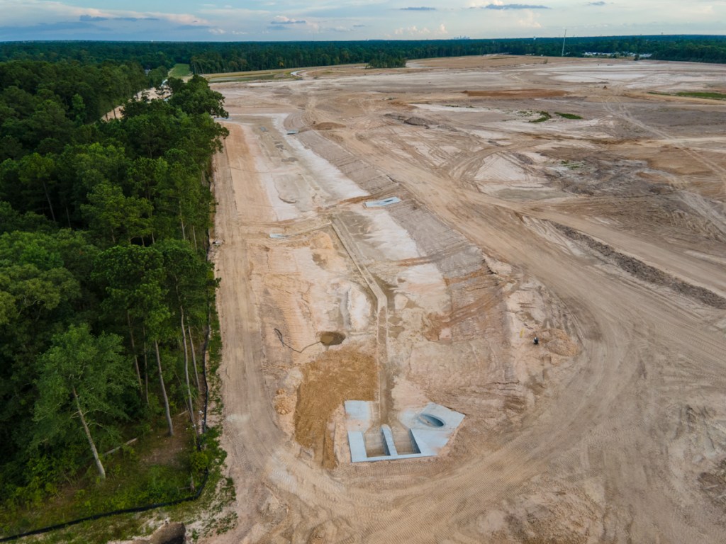
Castle Hill Partners in Austin, the company that owns CH-B Kingland LLC, did not return phone calls re: its development plans. However, since tollway construction is moving from west to east, it would make sense to develop the western portions in Montgomery and Harris Counties before moving east into Liberty County.
Kingland’s 2017 sales brochure shows that almost half of the western section lies in Montgomery County along the San Jacinto East Fork. The remainder of the western section lies within Harris County. Both portions lie partially within the City of Houston’s Extra Territorial Jurisdiction.
Western section of Kingland shows a 41.3 acre detention pond, plus seven smaller ponds. But it’s unclear whether they will lie in the floodway or floodplain.
FEMA’s National Flood Hazard Layer Viewer shows the extent of the floodway and floodplains in that area.
Crosshatched area = floodway. Aqua = 100 year floodplain. Brown = 500 year.
I interviewed a family in that small development south of Kingland property that straddles the Harris/Liberty County Line and discovered that they flooded from the East Fork during both Harvey and Imelda. They live more than 1.5 miles from the nearest mapped floodplain. However, that could soon change when the new post-Harvey flood maps are redrawn.
Anyone downstream on the East Fork or Luce needs to keep a close eye on this one. It has the potential to further alter the hydrology of the watershed.
Posted by Bob Rehak on 1/11/2021
1231 Days since Hurricane Harvey and 480 since Imelda
The thoughts expressed in this post represent opinions on matters of public concern and safety. They are protected by the First Amendment of the US Constitution and the Anti-SLAPP Statute of the Great State of Texas.
https://i0.wp.com/reduceflooding.com/wp-content/uploads/2021/01/20210101-RJR_4417-1-e1610410584123.jpg?fit=1200%2C800&ssl=18001200adminadmin2021-01-11 18:25:112021-01-11 22:16:33Thousands of Acres in East Fork, Luce Bayou Watersheds to be Developed as Part of Kingland
268 acres currently owned by Perry Homes could be turned into a regional floodwater detention basin if the purchase is approved by Houston City Council tomorrow and Harris County Commissioners Court on December 15.
If successful, the City and HCFCD would work together to reduce the volume of water flowing out of the headwaters of Taylor Gully.
Require a minimum detention rate of 0.55 acre-feet per acre of detention for any new development on tracts one acre or larger in size
Prohibit the use of hydrographic timing (flood-routing studies) as a substitute for any detention requirements, unless the project emptied directly into Galveston Bay.
Enforce these provisions both within the City and its extraterritorial jurisdiction.
The volume of detention ponds currently on Woodridge Village is about 40% short of what the new higher Atlas-14 requirements dictate. The current detention was approved and construction started before Atlas 14 became effective in Montgomery County.
If Council approves the money and ILA tomorrow for the Woodridge Village purchase, Harris County Commissioners would take up the issue at their next meeting on December 15. Approval by both bodies certainly would make Christmas much merrier and more hopeful for hundreds of Kingwood families devastated by flooding last year.
Kudos to Mayor Pro Tem Dave Martin for pushing this forward.
The outcome of the votes could affect projects considered in the Kingwood Area Drainage Analysis. If the purchase goes through, it could reduce or eliminate the need for widening and deepening Taylor Gully itself. It is not immediately clear whether the City and County have set deadlines for the design and construction of the detention basin.
Posted by Bob Rehak on 12/8/2020
1197 Days since Hurricane Harvey and 446 since Imelda
The thoughts expressed in this post represent opinions on matters of public concern and safety. They are protected by the First Amendment of the US Constitution and the Anti-SLAPP Statute of the Great State of Texas.
https://i0.wp.com/reduceflooding.com/wp-content/uploads/2020/12/20201207-Aerial-Dec-2020_425.jpg?fit=1200%2C800&ssl=18001200adminadmin2020-12-08 22:13:572020-12-08 22:43:54Woodridge Village Purchase on Wednesday’s Houston City Council Agenda
The Harris County Commissioners Court established the Community Flood Resilience Task Force (CFRTF) as a multidisciplinary, community-driven body. Its purpose: to ensure Harris County implements equitable flood resilience projects that respect community priorities. The group needs 11 more members who represent the geographic, gender, age, racial, and ethnic diversity of Harris County. These are all are unpaid, pro-bono positions. Learn more about the task force, its goals, responsibilities and composition here.
Represent the geographic, gender, age, racial, and ethnic diversity of Harris County
Demonstrate interest in and have a commitment to serving the community
Contribute meaningful time and effort to achieving the purpose and objectives of the CFRTF. “Meaningful time and effort” includes, but is not limited to, reviewing provided materials, contributing ideas and thoughts to flood resilience discussions, and meeting at least once every other month for a total of at least six (6) times per year.
If possible, members must also meet one or more of the following qualifications:
Represent one or more communities adversely impacted by flooding in Harris County.
Have knowledge of or interest in:
Innovative and environmentally sustainable approaches to flood risk mitigation
Equitable approaches to flood resilience.
Among the skillsets that the task force needs:
Public Housing
Public Health
Engineering/Construction
Urban Design/Planning
Flood-Risk Mitigation
Environmental Sustainability
Grassroots Community Organization
Equity and Social Justice
CFRTF Bylaws
Task force bylaws balance the diverse range of interests in Harris County. To learn more about the purpose and responsibilities of the task force, please review the following.
Final Guide to the Bylaws, a summary of the key elements English, Spanish
If you need the application translated, please email the CFRTF.
Posted by Bob Rehak on 11/21/2020
1180 Days since Hurricane Harvey and 429 since Imelda
https://i0.wp.com/reduceflooding.com/wp-content/uploads/2020/11/CFRTF.jpg?fit=1200%2C685&ssl=16851200adminadmin2020-11-21 11:52:352020-11-21 12:26:23Harris County Flood Task Force Looking for 11 More Members, How to Apply
In January, the City hired DRC Emergency Services, LLC (DRC) to begin mechanical dredging of the San Jacinto West Fork Mouth Bar. I’ve provided periodic updates on that. According to Houston Mayor Pro Tem Dave Martin, DRC has now officially completed 60% of that project.
In the meantime, other related dredging projects, including East Fork dredging and long-term Lake Houston maintenance dredging are reportedly taking shape. Here’s how pieces of the puzzle fit together. But one piece is still missing – long-term funding to pay for the maintenance dredging.
Two-Phase Program
DRC’s scope of work has two distinct phases:
Phase One will remove accumulated materials near and at the mouth bar on the West Fork of the San Jacinto River.
Phase Two will remove accumulated materials in the East Fork of the San Jacinto River AND other locations in Lake Houston.
West Fork Mouth Bar as of late June 2020.
During Phase One, 400,000 cubic yards of material will be removed over twelve months. To date, DRC has removed approximately 240,080 cubic yards of material. (See photo above.) That’s 60% in approximately 60% of the allotted time, so that part of the project is on schedule.
East Fork Mouth Bar as of May 2020. This areas went from 18 to 3 feet deep during Imelda, according to boater Josh Alberson. The above-water portion of this sand bar has grown three quarters of a mile since Harvey.
Phase Two of the project will consist of:
Hydrographic surveys of the West Fork of the San Jacinto River, the East Fork of the San Jacinto River, and Lake Houston to determine dredge material volumes
City of Houston advertising and awarding a dredging contract to the lowest responsive bidder
Phase Two will run simultaneously with Phase One to expedite dredging.
Dave Martin, Houston Mayor Pro Tem
Mayor Pro Tem Martin did not provide an update on where Phase Two currently stands. But residents have reported seeing survey boats on Lake Houston, and the East and West Forks of the San Jacinto.
Mouth bar forming at Rogers Gully on Lake Houston. Example of kind of projects being considered for Phase 2.Photo late June, 2020.
Long-Term Dredging Plan in Development
Additionally, during Phase Two, City of Houston and its partners will develop a long-term dredging plan for Lake Houston. City of Houston or the Coastal Water Authority will execute the plan.
The intention: to fund dredging operations in perpetuity.
This phased approach will obligate the full grant funding before the 87th legislative session in 2021. This grant funding was made possible thanks to State Representative Dan Huberty (District 127) through the passage of Senate Bill 500.
Mayor Pro Tem Martin credits Huberty for his dedication to the long-term maintenance dredging activities on Lake Houston. “Representative Huberty has been a champion for his residents and a great ally in seeing these additional dredging efforts come to fruition,” said Martin.
$40 Million Project
The total project is valued at $40 million (except for the perpetuity part). Funding for the immediate dredging projects comes through a combination of:
City of Houston Harvey Disaster dollars provided by Governor Greg Abbott
Grant dollars from the Texas Water Development Board (TWDB)
Harris County Flood Control District (HCFCD) Bond Program.
Long Term Funding – Still A Missing Piece of Puzzle
Lake Houston, a City of Houston asset, is losing capacity. Everyone has recognized that fact for decades. But as silt filled the rivers, inlets and lake, maintenance was deferred, reportedly for budgetary reasons. In 2017, during Harvey, the problem became so big that no one could ignore it anymore. Flooding was the immediate problem. But loss of water capacity is an even bigger, longer-term problem.
It’s one thing to have a long-term maintenance dredging plan and another to put it into action. But where will the money come from?
A tax on sand mines? Won’t work. Most aren’t in the City. Or even in Harris County.
Some have suggested creating a taxing district for lakefront homeowners. That won’t work either. Not enough of them. And it would create a stampede for the Oklahoma border. Moreover, it hardly seems fair; the lake is part of a City system that provides water to two million people and generates revenue.
The logical solution seems to be increasing the cost of water. Adding just a fraction of a penny per 1000 gallons should do it. Dredging isn’t just about reducing flooding. Or preserving views for lakefront homeowners. It helps preserve the lake’s capacity. And that benefits everyone.
As we develop a long-term dredging plan for the lake, we also need to consider a sustainable source of financing.
Posted by Bob Rehak on 8/12/2020based, in part, on a release by Houston Mayor Pro Tem Dave Martin
1079 Days after Hurricane Harvey
https://i0.wp.com/reduceflooding.com/wp-content/uploads/2020/08/20200306-RJR_9786.jpg?fit=1200%2C800&ssl=18001200adminadmin2020-08-12 13:45:302020-08-12 16:03:12Long-Term Lake Houston Dredging Plan in Development; West Fork Mouth-Bar 60 Percent Completed
This morning in a special meeting, Harris County Commissioners debated whether to raise taxes BEFORE they had a certified appraisal from the Harris County Appraisal District.
They chose to take no action for the time being.
Request by Budget Director
The first agenda item said, “Request by Budget Management for discussion and determination if the Court would like (1) to proceed with initial consideration of proposed property tax rates based on the July 24th Harris County Appraisal District (HCAD) estimate or (2) to take no action and wait to propose rates based on the Certified Appraisal Roll expected from HCAD in late August.
Commissioners Chose Option 2
The commissioners chose option 2, i.e., to take no action. Much of the debate had to do with accuracy. The budget director outlined several different scenarios that called for different levels of tax increases. One even was based on holding the tax rate constant.
But at least one scenario called for a tax increase that would have required voter approval in November. Getting the increase on the ballot, however, would have required making a decision before August 18 and the completion of the certified appraisal.
The agenda item refers to “late August” for the completion of the certified appraisal. Those concerned about a potential tax increase should watch the calendar for the Harris County Commissioners Court.
A portion of the debate and one call-in comment focused on the economic hardships that people are laboring under right now. The owner of a Chinese restaurant downtown said that her business was only 30% of the normal level. She and her family have been in business for more than 50 years. She said that they might not even be able to make their current tax payments and also said that she could not handle an increase.
This argument set the tone for the discussion. Several commissioners frequently eat at the restaurant.
At the end of the day, the commissioners voted not to take any action until they knew exactly what the tax base was. They feared raising the taxes too much or too little.
The County has not yet published the different budget scenarios considered in the meeting.
County Will Fight to Include Non-Citizens in Population Counts
The second agenda item stated: “Request by the County Attorney for authorization to file on behalf of the County friend of the court briefs and join in existing/future litigation that challenges federal efforts to exclude non-citizens in population counts when legislative boundaries are redrawn and to further authorize the County Attorney to engage Special Counsel at no cost to the County.”
A majority of the Court voted to approve this. It means the county will fight to include non-citizens in official census counts. That means, when legislative districts are redrawn (which they are after every census), Texas could wind up with more representatives in Congress rather than less. It also means that the composition of the congressional delegation could shift.
Uncertainty Surrounds Estimates of Non-Citizens
No one knows with certainty at this instant how many non-citizens live in Harris County.
So if the Migration Policy Institute estimate is correct, AND if Harris County is successful, the inclusion of non-citizens won’t be enough to create a new district. However, it will shift some boundaries.
The Texas Secretary of State estimates that as many as 100,000 residents statewide many not have attained citizenship. However, officials are skeptical of the estimates. They are based on the number of people who did not have citizenship when they applied for drivers’ licenses. Many may have attained citizenship after applying for the licenses.
So no one really knows at this point how the inclusion of non-citizens could affect congressional boundaries.
Posted by Bob Rehak on 8/6/2020
1073 Days after Hurricane Harvey
https://i0.wp.com/reduceflooding.com/wp-content/uploads/2020/08/Agenda-8.6.20.jpg?fit=1200%2C796&ssl=17961200adminadmin2020-08-06 13:32:092020-08-06 13:32:21Harris County Commissioners Vote to Take No Action on Raising Taxes at This Time
Correction on 7/4/2020: The article below was based on a City of Houston District E newsletter. It inferred that the City “applied for” five grants (in bullet points below). Other entities, such as the SJRA, applied for those. Mayor Pro Tem Dave Martin personally supports them.
The City of Houston has submitted several applications to the Texas Water Development Board (TWDB) for Flood Infrastructure Fund dollars. Among the projects was one for Taylor Gully Flood Damage Reduction. It consists of evaluating flood reduction alternatives plus design, permitting, and construction of a detention basin located on a 278 acre site to the north of the Elm Grove subdivision.
Looking SW atWoodridge Village as of 6/16/2020
Woodridge Project One of Six Apps
Other applications include:
San Jacinto River Sand Trap Development
Spring Creek Watershed Flood Control Dams Conceptual Engineering
Upper San Jacinto River Basin Regional Sedimentation Study
Lake Conroe-Lake Houston Joint Reservoir Operations Study
Harris County MUD #153 Siltation Reduction
“All of these projects submitted for funding promote regional resiliency and future sustainability in an effort to protect life and property from future flooding,” said Mayor Pro Tem and District E City Council Member Dave Martin. “The ability to submit these projects to the TWDB for funding would not be possible without State Senator Brandon Creighton’s writing of Senate Bill 7. We continue to applaud the Senator for his forward thinking and hope to receive funding for these projects. State Representative Dan Huberty has also been a vocal proponent for resiliency within our area and just beyond the City boundary. We are thankful to have him as a local engaged leader.”
Looking NW from US59 (foreground) over San Jacinto West Fork at the confluence of Spring Creek (left) and the West Fork (right). Spring Creek splits off to left. Its watershed contains several natural areas that might make candidates for flood control dams.
Neither Martin, nor his office, provided additional details on any of the grant applications.
However, from the wording of the release, it sounds as though state leaders are fully aligned and engaged to support the projects.
Woodridge Village Project Has Long History
The grants, if approved, could help reduce flooding throughout the Lake Houston Area.
Both the City and County have been silent on any deal since then. The County refused a Freedom of Information Act request to release the text of the motion, which was approved in a public meeting. They even protested release of the information to the State Attorney General.
Putting Application in Historical Context
The following is speculation, but speculation based on the historical context. It appears that when County Commissioners voted to demand that the City come up with half the the purchase AND construction costs, the City found it hard. The grant application, if successful, is a way for the City to help the people of Elm Grove, who flooded twice last year after Perry Homes cleared 268 acres of adjacent land.
At the time of the floods, less than 25% of the planned detention pond capacity was in place. Perry has since developed additional detention ponds that provide the other 75%.
A joint reservoir operations study seems necessary. Currently, FEMA is funding a preliminary engineering study to add additional gates to the Lake Houston Spillway. If FEMA also approved the money for construction of the gates, they will be a game changer.
The Spring Creek Watershed flood control dams would provide additional upstream detention. Community leaders identified that as a high priority after Harvey. They would reduce the amount of water coming downstream during a flood.
Sand bar blocking mouth of Rogers Gully has backed up water and contributed to flooding. Photo taken 6/16/2020.
Posted by Bob Rehak on 7/3/2020
1039 Days since Hurricane Harvey
https://i0.wp.com/reduceflooding.com/wp-content/uploads/2020/07/20200616-RJR_4383.jpg?fit=1200%2C800&ssl=18001200adminadmin2020-07-03 11:55:542020-07-04 14:02:25City Applies for TWDB Grants to Turn Woodridge Village Into Detention Basin and More
Perry Homes’ current contractors have excavated 3X more detention pond volume in ten weeks than the previous contractors did in virtually two years. During this past week, they finished excavating three ponds on the northern section of Woodridge Village. Together, they comprise 77% of the total detention volume for the whole site.
Excavation Done, but Finish Work Remains
That doesn’t mean they’re totally done with the ponds. Recent aerial photos show that they still have much finish work to do. That includes:
Shaping the sides
Creating backslope swales
Installing pipes to funnel water from the swales into the ponds and channels
Ensuring water can flow out of Adams Oaks in Porter on the west side of the subdivision into Taylor Gully as it previously did
Creating concrete “pilot channels” in the center of the ponds and larger channels
Planting grass along the sides of the slopes to reduce erosion
Installing outflow control in several places to hold back floodwaters
Building maintenance roads around the ponds
Elm Grove resident Jeff Miller, who monitors the progress of construction daily, says crews are already hard at work on many of those tasks.
Ponds NOT Expanded Beyond Initial Plans
Miller has compared the width and depth of ponds to the initial plans and verified that the ponds are being built to original specifications. Since the ponds were designed to meet pre-Atlas 14 rainfall requirements, that means the site will still hold 30-40% less runoff than needed to meet current regulations.
With the peak of hurricane season now less than two months away, Perry Homes is in a race against risk. The company may regret the six months of virtual inactivity between the completion of pond S2 and the start of work on ponds N1, N2, and N3 in early April.
The faster pace of current construction puts pressure on Harris County and the City of Houston to complete an offer if an offer will be made. Elm Grove residents lobbied the City and County to purchase the property and build a regional flood detention facility. They center would also help protect downstream residents on the East Fork and Lake Houston.
However, at a Kingwood Town Hall Meeting in February, Mayor Pro Tem Dave Martin announced that the City would not participate in a deal. He said it was the County’s responsibility.
Then in May, the County increased its demands. The County now wants the City to contribute land in lieu of cash to cover half the purchase AND construction costs for creating additional detention.
County and City Clamp Down on Communications
Since then, the County has clamped down on communications regarding this subject. Rumors suggest that all parties are still trying to make a deal happen. But the County has denied all FOIA requests and referred them to the Texas Attorney General for a ruling on their denials. That often happens when negotiations are in progress, according to a knowledgeable source.
What Happens Next?
At the contractor’s current rate of progress, it’s entirely possible that contractors will complete all work on detention ponds in July.
With approximately $14 million dollars invested in the property, with hurricane season here, with lawsuits pending, and knowing that the amount of detention is insufficient to hold a 100-year rain, Kathy Perry must be sweating bombshells.
Ms. Perry may be hoping for a City/County offer, but she can’t be counting on one. If she were, she could have sold the dirt coming out of those detention ponds. Instead, however, she’s building up land elsewhere on the site to keep her options open and develop the site if a deal falls through.
That dirt will have to be moved again at taxpayer expense if the county builds additional detention ponds.
Pictures of Site as of 6/19/2020
Here’s what the site looked like as of 6/19/2020.
Looking NW from over Taylor Gully toward Pond N2, the largest on the property.The connecting channel between N1 at the top of the frame and N2 along the western edge of the property has been excavated.Note the pilot channel that contractors have startedin the distance.At Mace Street in Porter, contractors created a concrete face for the twin culverts on the upstream side, but not yet on the downstream side. Note the earthen dam holding water back while contractors complete the pilot channel running off the bottom of the frame.Above Mace Street, contractors are still putting in pipes between the channel and backslope swales.The Webb street entrance to the site has been removed to connect N1 (out of frame on the top) with N2 (out of frame on the lower left).Looking SE at N1.Looking South at N3, which runs down the eastern edge of the property.More pipes are being put in to channel water from backslope swales to the pond so water won’t erode the face of the pond. Not the rills already cut in the dirt.Looking SE. The southern half of N3 where it connects with Taylor Gully in the upper right.N3’s connection to Taylor Gully is now wide open. It’s not clear how this connection will be completed to release the water at a slow controlled rate.The two culverts under the bridge over Taylor Gully should slow the water from N2 (upper right) and N1 (out of frame) down.
Need for Grass if Deal Not Reached Quickly
Note how the grass on the southern side of the gully has all died. That raises a question. If Perry, the City and County do not complete a purchase agreement soon, will Perry plant grass on the northern section to slow runoff. Right now, it’s all hard-packed dirt.
Most of northern section is hard packed dirt which increases runoff rate.
Planting grass over an area this large would be a big investment and might get in the way of construction if Perry decides to develop the land. But it will reduce flood and legal risks.
Posted by Bob Rehak on 6/20/2020
726 Days after Hurricane Harvey and 275 after Imelda
https://i0.wp.com/reduceflooding.com/wp-content/uploads/2020/06/20200619-DJI_0205.jpg?fit=1200%2C900&ssl=19001200adminadmin2020-06-20 14:57:582020-06-20 14:58:16Perry Contractors Now Focusing on Finish Work for Detention Ponds
Certainly, there are many honorable developers who try to build high-quality communities for people without adversely affecting downstream residents. I don’t wish to malign a whole profession. Nor do I want to fail to acknowledge the many wonderful communities they have built in this area.
But there are also some developers who put profit before people. They try to cut corners wherever they can and hope that nobody will notice. Especially regarding flood control. It’s expensive and easy because most people don’t understand it.
Grand Parkway Coming Soon To Wetlands Near You
The construction of State Highway 99, aka the Grand Parkway, has opened up vast new areas on the outskirts of Houston to developers. Many of those areas consist of wetlands and forests.
TxDoT is currently prepping land for Section H of the Grand Parkway almost all the way to FM 1960 on the east from US59.
From USGS. Wetlands near the path of Grand Parkway extension. Compare with maps above and below.
Visible Difference in Development Density Where SH99 Completed
The map below shows permit applications in the north Houston area. Compare the density of projects around sections of the Grand Parkway that have already been completed (left) with the areas on the east where the concrete has not yet reached.
This map shows permit applications in the northeast Houston area, both within the City and its ETJ (extra territorial jurisdiction. The Colony Ridge development featured below is outside the ETJ (green area) in the upper right of the map above.
Developers have even more projects underway outside the City’s ETJ (not shown on the map above).
How Development Can Affect Flooding
Kingwood residents have seen how one developer can contribute to flooding hundreds of homes. Last year, Perry Homes clearcut 268 acres north of Elm Grove before installing detention ponds. Hundreds of Elm Grove homes then flooded on May 7 and again on September 19, during Tropical Storm Imelda.
Below are recent photos of a massive 10,000 acre development in Liberty County near Plum Grove. It is about to become a 15,000 development now, thanks in part to Grand Parkway access. And yet it has only one small traditional detention pond.
Detention ponds slow down the rate of runoff to compensate for the loss of trees, wetlands and ground cover that have been replaced by streets and rooftops.
Their goal: to prevent downstream flooding.
Colony Ridge Accounts for All Growth in Liberty County In Last Decade
Colony Ridge can account for all the growth in Liberty County in the last decade. Below are some photos of Colony Ridge and its expansion near Plum Grove. The approach of SH99 will make it more accessible and therefore more attractive (at least from one point of view).
All aerial photos below were taken on 6/126/2020.
Looking north across the Grand Parkway extension toward Colony Ridge in Liberty County near Plum Grove.Just north of the Grand Parkway (upper left), you can see roads going in that will accommodate even more manufactured homes, aka trailer homes.The developer puts in roads, ditches, water and sewer. Fire hydrants? Forget it.
Developer’s Marketing Strategy
The developer tries to pass as many costs along to lot buyers as he can to maximize profit. He targets Hispanics. Residents tell me that sometimes two or three families may live in one of the homes you see here.
Nobody knows the real population of Colony Ridge because many residents are reportedly undocumented and uncounted.
Site work before parking a home is the responsibility of site buyers, many of whom openly burn brush to clear their lots. Like the developer, they’re trying to cut costs.
Land of Fire and the Forgotten
Resident burning brush on his property last Sunday afternoon.Residents aren’t the only ones burning.That smoke you see on the horizon is from dozens of brush fires set by the developer as he continues to clear land.Here’s one still smoldering.At this point, a major storm would bring the potential for uncontrolled erosion,just as it did in Woodridge Village in Montgomery County, above Elm Grove.As dry as it has been lately, the developer is burning brush piles next to woodlands. That increases fire risk. The barren surface also accelerates runoff and erosion, increasing flood risk.Note the haze and plums of smoke on the horizonand the vast expanse of exposed, packed dirt.The smoke is coming from burning piles of brush, such as these. If a fire spread into surrounding woods, local volunteer fire departments would be overwhelmed.No fire hydrants anywhere in sight.
If this were Houston, hydrants would be spaced at a minimum of every 500 feet. A firefighter told me that the spacing often depends of home values and population. Based on population alone, he believes this area should have hydrants.
One Small Detention Pond for 15,000 Acres
The developer has one detention pond (center) for the entire 15,000 acres. He relies on less efficient, in-ditch detention for additional capacity.Note the proximity to SH99 in the upper right.There are no detention ponds anywhere in the new areas being cleared. This is reminiscent of Woodridge Village which contributed to the flooding of hundreds of homes in Elm Grove.But Woodridge was only 268 acres. The developer relies on this and other drainage ditches to double as detention ponds in storms. But at the far end of this ditch……FM 1010 washed out during Harvey and destroyed one of the two major access roads into the development. The in-ditch detention failed. So has the county. The road has been out now for 1025 days, increasing the commute time for residents and the response time for firefighters.
Endless Loop of Construction and Destruction
State Highway 99 represents more than just a third loop around the City of Houston.
SH 99 will bring more developersand more people eager to escape downstream flooding issues.
Tapayer funded roads such as these create endless loops of construction and destruction. They are like a perpetual motion machine. Building one area floods another, causing people to move farther out and the cycle to repeat itself.
No one will admit it’s intentional, of course. The flooding is just a byproduct of greed. Cut a detention pond here. Substitute in-line detention there. Don’t bother planting grass to reduce erosion. Send your problems downstream. Let someone else worry about them.
One Chance
Do all developers think that way? Of course not. Many have principles and wonderful communities to show for them.
That notwithstanding, as one Splendora resident said, “They really only have one chance to get this right. If they screw this up, it will be almost impossible to fix and they will argue over who is going to pay for it for centuries.”
We are at that inflection point now.
Posted by Bob Rehak on 6/19/2020
1025 Days since Hurricane Harvey
The thoughts expressed in this post represent opinions on matters of public concern and safety. They are protected by the First Amendment of the US Constitution and the Anti-SLAPP Statute of the Great State of Texas.
https://i0.wp.com/reduceflooding.com/wp-content/uploads/2020/06/20200616-RJR_3705.jpg?fit=1200%2C800&ssl=18001200adminadmin2020-06-18 21:28:292020-06-18 21:57:39“The Developers Are Coming! The Developers Are Coming!”
Construction of State Highway 99, also known as the Grand Parkway, has turned south. It is now approximately 4.5 miles from FM1960, but more than 20 miles from reaching its goal of I-10. In the image below, taken on 6/16/2020, you can see it crossing the Luce Bayou Inter-Basin Transfer project and then heading through open farm land.
Looking southeast. Grand Parkway construction has now passed the Luce Bayou Inter-Basin Transfer Project. Approximately 4.5 miles remains before construction reaches FM1960 to the south.
The Grand Parkway will open up vast areas in Montgomery, Harris and Liberty counties for development. All of that will put pressure on Lake Houston, shown in the lower left of the satellite image below (which was taken seven months ago.
Now, more than ever, it’s important for these counties to work together to reduce the risk of flooding for downstream residents in Houston, which is the economic center of the region.
Without a vital, safe center, growth in the entire region could falter.
Posted by Bob Rehak on 6/18/2020
1024 Days after Hurricane Harvey
https://i0.wp.com/reduceflooding.com/wp-content/uploads/2020/06/20200616-RJR_3555.jpg?fit=1200%2C800&ssl=18001200adminadmin2020-06-18 15:33:432020-06-18 15:33:53Grand Parkway Construction Now Within 4.5 Miles of FM1960
When the developer sought approval of their general plan from the City of Houston Planning Commission, the City deferred approval. Instead they asked the developer to consult with the City Engineer and Harris County Flood Control, before coming back to the commission.
Despite the location of the development in the floodplain and floodway of the West Fork, ironically, the City had only procedural comments on the plans. The comments had to do with things like the spacing and labelling of streets. Incredibly, they did not refer to potential flooding or wetlands issues.
Pending Regulation Changes Could Affect Development
Specifically, the County wants the City to change Article III: Standards for Flood Hazard Reduction in the Houston Code of Ordinances, Chapter 19 Floodplain (September 2018):
19-33(a) Base Flood Elevation Requirements –Must also include a provision that no fill will be allowed to elevate structures proposed for the 100-year floodplain. These structures must be on open foundations designed by a structural engineer.
Where Property Is
Here’s where the property is. It wraps around the Barrington, which was elevated significantly and still flooded during Harvey. It also wraps around River Grove Park Kingwood Country Club, and Deer Ridge Park.
Purple area represents proposed site of Romerica’s Orchard Seeded Ranches Development.
Large Concentration of Forested Wetlands
All aerial photos below were taken on 5/11/2020.
Looking southeast from the southwest corner of Romerica’s property. Hamblen Road enters the from on the middle right. That’s the San Jacinto West Fork cutting through the top of the frame.Looking southeast while hovering over Woodland Hills Drive. The northern part of Romerica’s property lies between the front and back nines of the Kingwood Country Club Lake Course. That’s the Barrington on the right.Those same trees serve as a nesting ground for hundreds of great egrets.Looking southwest from near the entrance from Barrington. Deer Ridge Park wraps around the water tower.Looking SE over Woodland Hills and the Barrington entrance. The property contains three artificial lakes, which I believe were excavated to elevate the Barrington.Note how high lake level/water table is. River Grove soccer fields are on right. Look closely and you can also see the Kingwood Diversion Ditch entering the park from the lower right.
From the ground, beneath the dense canopy of trees, you can see palmettos galore. Palmetto plants are an important biologic indicator of wetlands. They only grow where the ground is underwater at least part of the year.
“Wetlands function as natural sponges that trap and slowly release surface water, rain, … and flood waters. Trees, root mats and other wetland vegetation also slow the speed of flood waters and distribute them more slowly over the floodplain. This combined water storage an braking action lowers flood heights and reduces erosion,” says the Agency.
They continue: “Wetlands within and downstream of urban areas are particularly valuable, counteracting the greatly increased rate and volume of surface- water runoff from pavement and buildings. The holding capacity of wetlands helps control floods… Preserving and restoring wetlands together with other water retention can often provide the level of flood control otherwise provided by expensive dredge operations and levees. The bottomland hardwood- riparian wetlands along the Mississippi River once stored at least 60 days of floodwater. Now they store only 12 days because most have been filled or drained.”
Fence separating Romerica property from Hamblen road after Harvey.
All those concerns still exist. Romerica should take a cue from the Humble ISD. They’ve had two ag barns in this area. The District abandoned one (that was actually on Romerica property), moved to higher ground, is trying to abandon the second, and hopes to move to higher ground yet again.
The thoughts expressed in this post represent opinions on matters of public concern and safety. They are protected by the First Amendment of the US Constitution and the Anti-SLAPP Statute of the Great State of Texas.
https://i0.wp.com/reduceflooding.com/wp-content/uploads/2020/05/20200511-RJR_2403.jpg?fit=1200%2C800&ssl=18001200adminadmin2020-05-27 15:05:412020-05-27 15:15:06Development Watch List: Orchard Seeded Ranches From the Air