10/17/24 – Harris County Flood Control District (HCFCD) held a meeting Wednesday night at the Kingwood Community Center to explain the scope of its maintenance activities. The exhibits were designed to raise awareness of the types of things HCFCD does in order to help educate the public in advance of the vote on HCFCD’s Proposition A.
Proposition A would increase HCFCD taxes 63 percent.
Not discussed at the meeting:
A basis for the percentage increase in the tax rate
Justification for the amount of the tax increase, i.e., linking objectives/tasks to cost estimates and budgets
How, where or when the additional money would be deployed
For those who couldn’t make the meeting, I’ll provide a brief recap of the exhibits below. There was no formal presentation. Residents walked from table to table and asked the staff questions about the oversized poster exhibits shown below. Some of the type gets pretty small when reproduced on a cell phone or tablet, so I’ll provide some context.
At the end, I will also provide some feedback from attendees.
What Does Proposition A Include?
The first poster talked about the proposed tax increase. The small type explains the before and after tax rates if Prop A is approved. The HCFCD tax RATE would go from 3.316 cents to 4.897 cents per $100 of assessed valuation. That’s a 57% increase in the rate. What they don’t show is an average 6% increase in valuations this year, bringing the total increase in your tax BILL up to 63%. The rate is applied to a larger base.
The small type says that the average homeowner would see an increase of $60/year. Altogether, the new tax would generate $100 million of additional revenue for HCFCD.
Here is the language you will find on your ballot. Notice that it says the new tax would go toward “operating and maintaining the District’s flood-risk-reduction infrastructure.”
Text of HCFCD Tax Proposal
The reference to operations would let the $100 million be spent on virtually anything…like the $3 million Commissioners Court approved last week to hire a consulting firm to write the county’s resilience plan.
Scope of Maintenance Activities
The rest of the posters discussed different types of maintenance.
Examples of preventative maintenance include mowing and debris removal.
They vary throughout the year by season. This chart shows seasonal shifts in emphasis. For instance, they plant trees in the fall and winter.
Activities change by the season.Channels in the Kingwood area that have received maintenance help since Harvey.Forward-looking maintenance includes things like tree planting; selective clearing; and planting of native grasses and wildflowers.
HCFCD also does major maintenance projects that border on capital improvement projects.
Examples include sediment removal from channels; channel sidewall replacement; repairs to concrete lining and outfalls; and erosion repairs.
See before-and-after examples below.
Service Requests
The pie-chart below shows the major types of service requests that members of the public request. The top categories are:
Debris 29%
Ponding Water 13%
Tree 12%
Unauthorized use 11%
Erosion 10%
Vegetation Overgrowth 9%
Note also how the level of service requests has remained relatively constant for the last four years. There is less than 5% variation.
This heat map shows where the most service requests came from in the county.
Precinct 4 is the pinkish color at the top of the map.
Beryl and the Derecho
The biggest effort in recent years has been debris removal following Hurricane Beryl and the derecho.
HCFCD/FEMA contractors have removed 40,000 tons (80 million pounds) of debris so far this year.
Mixed Feedback/Support
Dee Price, KSA President, was positive. She said, “After attending the Harris County Flood Control District’s public meeting on Proposition A, it is my assessment that Harris County Flood Control District needs additional funds to maintain all of the infrastructure for which it is responsible. It is my opinion that Kingwood would benefit if HCFCD receives additional funds that would enable them to maintain the drainage infrastructure in Kingwood.”
Jeff Miller, an Elm Grove resident who lives near Taylor Gully, said, “HCFCD freely admitted that their performance has been falling short for a long time but that with more funding, they can catch up. I plan to vote for Prop A, but based on our experience with the 2018 flood bond, I’m doing so reluctantly.”
I was skeptical based on previous experiences with the 2018 Flood Bond and 2022 Bond. County commissioners changed those deals after voters approved them. “The same thing could happen with Prop A and the Lake Houston Area could wind up funding projects everywhere but here.”
Turnout for the meeting was approximately 40 people – very low compared to the 13,000 that flooded in the Lake Houston Area in recent years.
Only one thing is certain – either way, you have the power to send a message with your vote.
Two Additional Meetings
HCFCD has scheduled two additional Zoom meetings for people who couldn’t attend in person.
Thursday, October 24 | 12:00 – 1:00 p.m
Wednesday, October 30 | 12:00 – 1:00 p.m.
Posted by Bob Rehak on 10/17/24
2606 Days since Hurricane Harvey
https://i0.wp.com/reduceflooding.com/wp-content/uploads/2024/10/20241016-Service-Request-History.jpg?fit=1100%2C885&ssl=18851100adminadmin2024-10-17 18:32:102024-10-17 18:32:11HCFCD Explains Scope of Maintenance Needs, Proposition A
10/16/24 – Harris County Flood Control District (HCFCD) and Precinct 3 will host a tax meeting at the Kingwood Community Center tonight starting at 6 PM. The purpose: discuss the thinking behind HCFCD’s request for what amounts to a 63% increase in taxes to cover operations and maintenance.
See details below.
Ask Tough Questions
Please come to the tax meeting. The community needs your support.
The 63% increase to tax bills will result from a 56% increase in the tax rate applied to a 7% increase in property valuations.
Is it worth it? Whether you see any benefit from the money depends on where you live in the county. Up here in the northeastern part, we’ve been fooled twice already.
When we were promised the 2018 flood bond would take care of the worst flooding first. And when we were told each of the four precincts would get at least $220 million from the 2022 bond. Commissioners Ellis and Garcia along with County Judge Hidalgo changed each deal after the fact.
Fool me once, shame on you. Fool me twice, shame on me.
So come prepared to ask tough questions. Like:
Why haven’t we seen any benefit from the flood bond after six years?
Six years in, money from the 2018 flood bond has not been distributed fairly across the county. The far northeastern part of the county has been severely punished for its Republican leanings, despite having some of the worst flooding in the county.
Chart showing feet above flood stage of 33 gages of misc. bayous in Harris County during Harvey.The four gages on the left all feed into Lake Houston
Harris County has 23 watersheds. Since Hurricane Harvey:
The top 11 have received $1.2 billion in flood mitigation funding.
The bottom 11 have received $172 million.
The average difference? 7X. Here’s what that looks like.
Through third quarter 2024. Source: HCFCD data obtained via a FOIA request.
The San Jacinto River, Luce Bayou and Jackson Bayou watersheds all fall into the bottom 11.
So now that we’ve funneled more than a billion dollars worth of capital improvement projects into low-income areas, who do you think will have the greatest maintenance needs?
I’m going to see what they say tonight at the tax meeting before I make any recommendations. Hope to see you there.
Bring a neighbor. Pack the room.
Posted by Bob Rehak on 10/16/2024
2605 Days since Hurricane Harvey
00adminadmin2024-10-16 16:54:342024-10-16 16:57:35Flood Control Tax Meeting Tonight at Kingwood Community Center, 6 PM
July 21, 2024 – Last week, Harris County Flood Control District (HCFCD) quietly shared this year’s flood-bond update with Commissioners Court. The update came during widespread power and internet outages from Hurricane Beryl that limited its visibility.
Combining the data in this flood-bond update with data from other sources reveals the impact of the County’s political divide and Equity Prioritization Indices. Both have affected projects in the Lake Houston area and Precinct 3 negatively.
But first some good news.
More Partner Funds Now Secured than Required by Original Bond
The total of secured funding now exceeds $5.2 billion. That includes the $2.5 billion approved by voters in 2018 plus $2.7 billion in other funding secured since then.
The additional funds include grants and matching funds from city, state and federal governments plus other local organizations, such as municipal utility districts. It also includes $87 million in Bond ID Z-07 – the Bond Program Reserve, formerly known as the Flood Resilience Trust.
Commissioners Court allocated this money to backstop bond funding before a massive infusion of funds from the General Land Office and the U.S. Department of Housing and Urban Development in 2022.
HCFCD says it is working on revising costs to reflect inflation and the rising cost of property acquisition since then. However, it appears that HCFCD did not include inflation-adjusted project estimates in the current update.
Dollars Spent vs Dollars Secured
Regardless, we are now at a point in the bond where available cash covers the original estimates. So looking at dollars spent vs. dollars secured gives us a reasonable feel for how close we are to completing flood-bond projects in various watersheds. See the bar graph below.
Compiled by combining 2024 Bond Update Appendix B on Page 10 with spending data obtained separately via FOIA request.See data in table below.
Brays and Greens are more than 80% complete. Five others are more than 50%.
Meanwhile, 15 others are less than 50%. And of those, 10 are less than 25%. The county’s largest watershed, the San Jacinto, is only 19% complete (“spent”).
The graph above does not include Carpenters Bayou. It was an anomaly at 1762%. The 2021 bond update included only half a million dollars for a study there. But HCFCD has spent almost $9 million so far. Including Carpenters in the bar graph distorted the scale and obscured the differences between the other watersheds. However, I did include it in the table below.
Compiled by combining Bond Update Appendix B on Page 10 with spending data obtained via FOIA request.County-wide projects not included.
Next month will mark the sixth anniversary of flood-bond approval. The bond was originally intended to be a 10-year program. So, totaling all these figures, we are about 40% done in 60% of the time. There’s certainly room for improvement on that front.
Projects in some watersheds are stalled while projects in others near completion. Take, for instance, the Kingwood Diversion Ditch and Taylor Gully Projects in the San Jacinto Watershed. The Kingwood Area Drainage Analysis identified them as the top two projects in Kingwood back in 2020.
But not a shovel full of dirt has been turned yet on the Diversion Ditch project. And a $1,000 excavation and removal contract on the Woodridge/Taylor Gully project was terminated last November when only one third complete.
Partisan Changes Negatively Impact Precinct 3
Another thing to look at: changes to projects (Dollar Increases or Decreases; Project Deletions or Additions). While a certain amount of changes are normal when dealing with rough, early estimates, in this case, the changes also reflect a partisan bias.
Harris County has three Democratic commissioners and one Republican – Tom Ramsey in Precinct 3.
Thirty projects affecting the three Democratic Precincts increased by $162.6 million – $54.2 million per precinct on average. But projects in the lone Republican precinct increased only $27 million. Thus, the three Democrats each benefited twice as much from additions as the lone Republican.
Likewise, 12 projects in the three Democratic Precincts decreased by a total of $92.6 million or $30.6 million per precinct on average. But Ramsey’s precinct lost $40.5 million.
Ramsey lost $13.5 million more than he gained.
Ellis, Garcia and Briones each gained about $8 million more than they lost.
When watersheds crossed precinct boundaries, I split dollars evenly among them. For example, if a project increased in value by $10 million and benefited one Republican and one Democratic precinct, I allocated $5 million to each. While that may not be precisely accurate in all cases, more precise data is not readily available.
To see the evolution of the bond fund through various iterations during the last six years, see the Harris County Flood Control District tab on the ReduceFlooding Reports page.
Other Items of Note
I did not include Countywide Expenditures in the calculations above even though they took a large hit. Their decrease shows up in corresponding increases for watershed projects. And I was more interested in how those were skewed.
However, one item definitely deserves future exploration: the $50 million decrease in “Federal Grant Funded Volunteer Home Buyouts.” Typically, the Federal Government grants funds for specific purposes. Where did this money go? The 2024 flood-bond update does not say.
Also of note: HCFCD currently has 20 projects in construction or turnover. The District has spent more than $2 billion in bond and partnership funds out of the $5.2 billion now available.
The latest bond update points out that of 181 original projects, 42 have been completed and closed out.
Equity Being Redefined Again
Separate from the bond update, Commissioners approved an expansion of equity guidelines last week. Item 18 on the agenda discusses an expanded definition of “equity” that will be used to allocate future flood mitigation dollars. It includes three components:
Structural Equity – righting historical wrongs
Procedural Equity – implementing procedures, policies and programs for groups previously not considered.
Socio-emotionally Intelligent Equity – mitigates the impacts of interpersonal, individual, structural, systemic, and institutional racism and sexism.
More news to follow when I figure out how all that will affect flood-control-mitigation dollars which have historically correlated to flood damage more than sexism.
At the very least, the imposition of new metrics on projects will slow down project scoring and implementation. It’s additional overhead burden on already complex processes. But my real fear? More and more of the San Jacinto watershed budget will slip away to other watersheds.
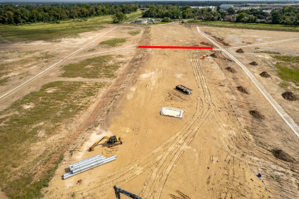
On 3/6/24, Harris County Flood Control District (HCFCD) revealed its preliminary recommendations for the Kingwood Diversion Ditch. The recommendations come out of a preliminary engineering report (PER) for the project. And HCFCD is still soliciting public comments.
Recommendations from Preliminary Engineering Report
HCFCD initially considered three alternative scenarios and dismissed one. It then spent most of last night’s meeting comparing the other two and discussing why it preferred one.
The proposed project alternative recommends:
Channel conveyance improvements to the Diversion Ditch
A diversion structure at the intersection of the Diversion Ditch and Bens Branch to take enough water out of Bens Branch to bring it up from a 2-year level of service to a 100-year level.
Bridge replacements at Kingwood Drive, Walnut Lane, Deer Ridge Estates Boulevard and the pedestrian bridge at Lake Village Drive
The ultimate goal of the Kingwood Diversion Ditch Project is to reduce the risk of structural flooding associated with the Bens Branch channel.
HCFCD
Improvements to One Channel Improve Another
The Kingwood Diversion Ditch is a man-made channel that was constructed prior to 1978. The channel diverted excess stormwater from Bens Branch and gave it an alternate route to the West Fork of the San Jacinto River.
The two channels largely operate as one unit. But HCFCD has room to expand the ditch and not Bens Branch. That’s because large portions of the Bens Branch Channel remain natural and are flanked by greenbelt trails, near and dear to the hearts of residents.
The Kingwood Diversion Ditch, however, has ample right of way and room for expansion. Even though, the Diversion Ditch operates at 100% of its design capacity, expansion of the Diversion Ditch can reduce the water surface elevation along Bens Branch without destroying the natural character of the stream.
The two alternatives that made the initial cut each recommended widening and deepening the Diversion Ditch channel. Exact dimensions/increases, however, will not become clear until final construction plans are developed.
Proposed widths for the bottom of the channel could vary from 10-80 feet. Top of channel widths could vary from 150-190 feet.
HCFCD said only that widths would vary along different portions of the channel and that, altogether both channels should be able to handle 100-year rains when the project is complete. The Kingwood Area Drainage Analysis revealed that portions of Ben’s Branch flooded in a 2-year rain.
The screen capture below shows benefits of the recommended alternative (#3).
HCFCD recommended Alternative #3 because of savings on maintenance.
Money Not Yet Identified to Fund Improvements
However, money does not currently exist to fund ANY of the three options. Almost seven years after Harvey, only $3.9 million has been committed. But costs are estimated at $54.5 million.
Screen capture from PER review meeting.
HCFCD emphasized that it always looks for funding. The District laid out a sequence of future events. Next steps:
Present the preliminary engineering report to commissioners court in two weeks.
Commission final design
Additional community engagement meeting
Secure funding
Begin construction
Need for Local Disaster-Mitigation Funding
The funding challenges, almost seven years after Harvey when the sense of urgency has dissipated, underscore the need for communities everywhere to plan for their own flood mitigation.
We can’t expect the federal government to ride to the rescue for every issue in every community. People in Kentucky don’t want to pay for our Diversion Ditch any more than people in Kingwood want to pay for a Diversion Ditch in Kentucky.
Switching gears, the Lake Houston Redevelopment Authority will hold a separate meeting tonight at the Kingwood Community Center from 5-7PM to discuss plans for the second phase of Northpark Drive Expansion. Hope to see you there.
Posted by Bob Rehak on 3/7/2024
2382 Days since Hurricane Harvey
https://i0.wp.com/reduceflooding.com/wp-content/uploads/2024/03/20240306-Screenshot-2024-03-06-at-6.50.05%E2%80%AFPM.jpg?fit=1100%2C612&ssl=16121100adminadmin2024-03-07 14:38:022024-03-07 15:00:21Preliminary Recommendations for Kingwood Diversion Ditch Announced
This morning at 10:34 AM, the last remains of another Forest Cove townhome complex toppled to the ground. The HCFCD demolition contractor nibbled away at it last week and earlier this morning. Eventually, all but a narrow strip of the last townhome in the complex had turned into a pile of rubble.
That strip started to lean. Then, suddenly, one more touch from the excavator, and the building collapsed on itself with a billowing cloud of dust and a thunderous boom. When the dust cleared, only one last complex remained standing.
As of Saturday, 7/16/22, one of the last three buildings was completely gone along with half of the second.Early Monday, 7/18/22, demolition of the remaining portion of the second building started again.As the excavator clawed away at the building, it started to lean.Periodically, the excavator would pile more rubble under itself so it could then reach higher. Note falling doors, walls and floors, frozen in space by the camera’s fast shutter speed.What took months to build came down in seconds.Note the severe bowing of the wallon the right.
Final Collapse Caught on Camera
At this point, I sensed the building would soon collapse. So, I switched from the drone to my Nikon which can shoot many more frames per second. And then it started…
With parts of the second and third floors removed, along with most of the truss structure in the attic, the remainder of the building started to collapse in on itself.A chimney came tumbling forward.The final collapse took less than 10 seconds. Three minutes later, the dust had cleared.
Next Steps
Contractors will extract any recyclable waste from the rubble. Then, they will crush what remains so that it takes less space in a landfill. Finally, they will remove the concrete from the foundation and likely recycle that, too.
Eventually, this area will return to nature. However, what form that takes has not yet been determined. Typically, HCFCD partners with other organizations such as the Houston Parks Board to create and maintain improvements such as trails, parks or recreational space. In fact, the Houston Parks Board West Fork Trail currently ends behind the rubble in the photo above. The Parks Board plans to extend it to Edgewater Park at US59, so hikers and bikers can connect from the Kingwood Trail System to the Spring Creek Greenway.
Demo Date for Last Building
After this morning, only one Forest Cove townhome complex remains standing. That’s at 1020 Marina Drive near the community swimming pool. According to Amy Stone, a Flood Control District spokesperson, HCFCD will demolish that building starting August 1, 2022. More news to follow.
Posted by Bob Rehak on 7/18/2022
1784 Days since Hurricane Harvey
https://i0.wp.com/reduceflooding.com/wp-content/uploads/2022/07/20220718-DJI_0249.jpg?fit=1200%2C799&ssl=17991200adminadmin2022-07-18 13:22:152022-07-18 14:54:27Caught on Camera: Moment Forest Cove Townhome Toppled
Harris County Flood Control District (HCFCD) is accelerating its spending on flood mitigation projects. I compiled the chart below with data from a FOIA Request. This request parallels an earlier request at the end of the first quarter and includes spending through the end of the third quarter. In the 3.5 years since the flood bond, HCFCD has completed many preliminary studies and engineering designs. Now many projects are moving into the capital-intensive phases: Right-of-Way Acquisition and Construction.
Current Spending Rate is 8X over pre-Harvey Rate
Comparing the periods before and after Harvey, spending per month tripled. And comparing the last six months to the post-Harvey period, you can see that the pace accelerated another 2.75X. The average for the last six months is up a whopping 8X compared to the pre-Harvey period.
HCFCD Flood Mitigation spending is rapidly accelerating.
That’s good news.
Where/When Spending Occurred
The chart below shows where HCFCD has spent that money. It ranks watersheds by total spending. But within that, you can see tremendous variability between the pre- and post-Harvey eras. In some watersheds, such as Sims, HCFCD largely completed projects with its partners, before Harvey. In other watersheds, such as Little Cypress, you see the opposite. HCFCD accelerated spending on land acquisition as part of its Frontier Program to help prevent, rather than remediate flooding.
Looking at spending before and after Harvey shows the most watersheds ramping up spending as a few taper off.
Four Watersheds Have Received 53% of All Spending since 2000
The flood bond prioritization framework helps shape the curve above. It gives priority to low-income, socially vulnerable neighborhoods. Those projects started first while others wait.
Thus, most of projects in low-income watersheds cluster toward the left. Likewise, with a few exceptions, more affluent watersheds tend to cluster toward the right.
In the years ahead, as HCFCD completes more projects on the left and begins more projects on the right, the slope of the curve may change.
Spending continues to be concentrated in a handful of watersheds. Four have received more than half of all dollars since 2000.
In the meantime, however, looking at subsets of this data, reveals much about priorities. Only five watersheds out of 23 have been allocated significant dollars above the average.
If you took Cypress Creek out of that mix, four other watersheds would be at the average. And fourteen would be below it.
But the top four watersheds alone comprise 53% of all spending since 2000.
Additional Analysis to Follow
In the next few days, I will examine other aspects of spending and what drives it. Those other aspects will include, but are not limited to:
Where the most damage has occurred
Population density
Watershed size
Percent of low-to-moderate income residents
Partnership funding
More news to follow.
Posted by Bob Rehak on 12/9/2021
1563 Days since Hurricane Harvey
The thoughts expressed in this post represent opinions on matters of public concern and safety. They are protected by the First Amendment of the US Constitution and the Anti-SLAPP Statute of the Great State of Texas.
https://i0.wp.com/reduceflooding.com/wp-content/uploads/2021/12/Spending-Acceleration-Bar-Chart.jpeg?fit=1200%2C900&ssl=19001200adminadmin2021-12-09 15:31:072021-12-09 16:04:49HCFCD Accelerating Spending on Mitigation Projects
Location of HCFCD’s Cutten Floodwater Detention Basin
The basin includes 5 separate Basin Compartments (BCs). One is on the north side of the Bayou (BC5) and four are on the south side (BC1-4).
The $16.2 million expansion will add 866 acre-feet of stormwater storage capacity to the previous 677 acre-feet. That’s enough to lower the water surface elevation by .36 feet throughout the surrounding floodplain.
When complete, the 235-acre complex will have enough capacity to hold a foot of stormwater falling over 2.4 square miles.
Photos Taken 10/15/2021 Show Current Construction Status
Looking E at the extension of Greens Road between BC3 (right) and BC4 (left). Red line indicates path of culvert under roadbed.Looking W in opposite direction. Greens Bayou is on right. Greens Road (coming from top of frame) will be extended south along ridge that bisects BC3 and BC4 in foreground. BC1 and BC2 are in background on either side of Greens Road. Hollister cuts through the frame from left to right.Looking NW across Hollister toward yet another detention pond, BC5.Looking SW across the intersection of Hollister (left) and Greens Road (right). Excavation of BC1 still has a way to go. On Friday, muddy conditions were slowing down the work, but if you look closely, you can still see heavy equipment working in the distance.
How Ponds Will Work with Bayou, Surrounding Developments
These ponds will function two ways. They will take stormwater:
Out of Greens Bayou when it starts to overflow.
Directly from surrounding subdivisions before it gets into the bayou.
It’s important to understand that County/Municipal neighborhood drainage and HCFCD infrastructure often pre-date current building and development codes, as they do in this area.
As cities and precincts re-grade and reconstruct streets with more and bigger storm sewers that get water out of neighborhoods faster, that water needs a place to go – without flooding others downstream.
In this area, these ponds will be that place. Everything has to work together. The very first sentence of the Texas Water Code Section 11.086 states, “No person may divert … surface waters in this state … in a manner that damages the property of another…”
Stormwater detention basins like these also provide greenspace and recreational opportunities, such as public parks.
HCFCD expects to complete the Cutten Project in the summer of 2022.
The Woodridge site already contains five small detention ponds and HCFCD has room in the center to add more. Perhaps the Woodridge site will look somewhat like this one before things are all over.
Late this week and early next will be the fourth anniversary of Harvey’s four day rampage through the Houston area. The storm broke so many records that NOAA retired its name. A year later, still reeling from the storm’s effects, Harris County voters approved a $2.5 billion bond issue to catch up with decades of chronic underfunding for HCFCD.
Since then, the rate of spending on flood mitigation projects has more than doubled. And the rate will accelerate even more as more projects move from engineering to construction.
High-Level Findings
Three years into a 10-year bond, HCFCD has spent slightly more than 30% of the money. That puts them exactly on track time-wise.
$251 million in contracts have been awarded to engineering companies
$552 million in contracts have been awarded for construction of capital improvements and repairs.
27 projects have completed, removing 11,000 homes from 100-year floodplains
Another 660 buyouts have been completed with another 662 in process.
Back in 2018, the Harris County Flood Control District (HCFCD) vowed to be open and transparent with bond funds. This report shows how, when, and where it spent the public’s money.
Accurate Snapshot of Progress
Until now, HCFCD’s website was the primary means for communicating with the public. But information was scattered across hundreds of pages and updates took place incrementally. That meant information on some watersheds was current and others could be months old. That made it difficult to get an accurate snapshot of progress.
To rectify this problem, HCFCD last week released the first in a series of new monthly reports. It gives everybody in every watershed information about what’s happening that affects them…at a glance.
Types of Information Included
The first report is 37 pages and tracks spending through the end of July 2021.
It’s broken down into a series of sections that include:
An introduction that summarizes active bond projects, grants, local partner funding, buyouts, contracts awarded, projects completed, community engagement, floodplain preservation, selective clearing and turf establishment
A visual timeline that tracks the progress of projects by month and year
Key performance metrics
Recent news
A GANNT chart showing the stages and progress of every single project approved by voters
Eight maps showing cumulative spending from different sources of funding
Two maps showing the location and spending to date on all active construction and maintenance projects in the county.
The Ultimate Go-To Doc on Where Your Money Has Gone
This is the ultimate go-to document for everyone who wants to know what’s happening near them. And HCFCD vows to update it monthly.
If you compare this to articles I previously published on funding, keep in mind that this data includes:
Four more months of spending
Only spending starting August 2018 (approval of the bond fund).
So numbers may vary from posts you see on ReduceFlooding’s Funding page. I also included historical spending going back to 2000 to help put the current spending in context.
Replacing Fear with Facts
All in all, HCFCD’s monthly spending reports will advance the public dialog. It will be good to have discussions based on facts, not just fear.
Flooding is one of the most terrible things that can happen to someone. It produces lasting trauma and alters the trajectory of lives.
To complicate matters, not many people understand what a flood control project is. They may see a jogging trail in a park and not realize it is a massive flood detention basin. They may not realize that a channel through their neighborhood has been widened. And they likely don’t know how to track historical gage data to see if their neighborhoods are flooding from bayous or streets.
This report won’t solve all those problems. But it will go a long way toward helping people understand they have not been forgotten.
Posted by Bob Rehak on 8/22/2021
1454 Days since Hurricane Harvey
https://i0.wp.com/reduceflooding.com/wp-content/uploads/2021/08/20210822-Screen-Shot-2021-08-22-at-12.37.32-PM.jpg?fit=1200%2C925&ssl=19251200adminadmin2021-08-22 12:48:392021-08-22 12:57:08HCFCD Issues Update on Bond Spending In Advance of Harvey’s Fourth Anniversary
Location of six six high-income watersheds used in the same analysis
Voter turnout for the 2018 Harris County flood-bond referendum
Damage from Harvey
Ironically, low-income watersheds had the lowest turnout for the 2018 flood-bond referendum and they’re getting the vast majority of flood mitigation funding.
Previous articles in this series have shown that, out of 23 watersheds in Harris County, six low-income watersheds:
The low-income watersheds are all located primarily inside the Beltway.
Most of Greens Bayou is inside Beltway 8, though a portion of it wanders just outside.
Location of Watersheds with Highest Income
Now let’s look at the location of the six high-income watersheds.
High-income watersheds are all outside the beltway.
Who Approved that $2.5 Billion Flood Bond?
Now look at the voter turnout map below from the 2018 flood bond referendum.
Light areas had the lowest voter turnout.
Dark areas had the highest voter turnout.
Note the area inside the yellow outline. It contains all the watersheds that Commissioners Ellis and Garcia complain about the most as having the least funding: Greens, Halls, Hunting, White Oak and Sims.
To see turnout in both absolute numbers and percentages in individual precincts, go to the interactive version of this map. Click on the visual above or here.
Some precincts in those watersheds had 0 voters. That’s right. No one showed up at the polls. At all. Many precincts had less than 1% turnout. Those light tan-colored areas generally had 1-5%.
The darkest areas, such as those around Kingwood, had turnout in the 20 to 30% range – generally 5-20 times higher than in the neighborhoods where most of the money is going.
Compare damage in Harvey (below) with the area outlined in yellow in the map above.
When you consider these four maps together with the historical funding data discussed in previous posts (see links below), they show that most of the money is already going where most of the damage was.
But large pockets of damage exist elsewhere that get comparatively little to no funding.
For instance, in the map above, note the curving arc of damage along Cypress Creek in the northern part of the county which extends into the Humble/Kingwood area.
People in those damaged areas turned out in high percentages for the flood bond. But they are seeing the vast majority of flood-mitigation projects being built in neighborhoods that didn’t even bother to vote in many cases. That doesn’t bode well for future bonds referendums.
Misleading Statements Undermine Trust in Government and Future
Some political leaders are telling poor people that flood-mitigation projects are all going to rich neighborhoods and the Houston Chronicle blindly repeats what they say without checking the real numbers. Or even bothering to mention projects already completed.
Twitter feed of Chronicle writer who wrote the article above.
But as I’ve shown in previous articles (see links below), depending on how you measure it, up to three quarters of the money is actually flowing to poor neighborhoods.
Funding in six highest and lowest income quartiles.
Funding in six low income watersheds compared to 15 higher income watersheds
Yet poor people believe all the money is going to rich watersheds – because that’s what their leaders tell them. And rich people see the lion’s share of the money going in the opposite direction.
Everyone believes someone else is getting the funding. So who would vote for another flood bond at this point? No one.
How are you going to convince people that taxed themselves $2.5 billion – and think they aren’t receiving any benefit from it – to vote for the next bond?
We need to restore trust in government by giving people accurate information, not misleading them with racial rhetoric for political gain. More on that tomorrow.
The thoughts expressed in this post represent opinions on matters of public concern and safety. They are protected by the First Amendment of the US Constitution and the Anti-SLAPP Statute of the Great State of Texas.
https://i0.wp.com/reduceflooding.com/wp-content/uploads/2021/06/Voting-Map-W-Legend-and-Outline-Small.jpg?fit=1200%2C599&ssl=15991200adminadmin2021-06-26 10:05:322021-06-26 12:34:20Watersheds with Low Voter Turnout Get Most Flood-Mitigation Funding
Second in a Series of Eight Articles on Flood-Mitigation Funding in Harris County
If the charges of racial and income bias in flood-mitigation funding in Harris County were true, you would expect the poorest neighborhoods to get less funding than the most affluent. But the opposite is true. They get a billion dollars more
Contrary to the “equity” narrative repeated ad nauseum in Harris County political circles, an analysis of flood-mitigation spending shows that JUST SIX low-income watersheds already:
Received a billion dollars more than six high-income watersheds since 2000
Averaged three times more funding per watershed
Data obtained from HCFCD via FOIA Request compares six highest and lowest income watersheds.These numbers include only capital improvement projects, not maintenance.
Data obtained via a Freedom of Information Act (FOIA) request debunks the narrative that falsely claims high-income watersheds get more funding because they have higher home values. Higher home values theoretically create higher Benefit/Cost Ratios. And some political leaders claim that causes the Federal government to favor projects in affluent neighborhoods, compared to poor.
So, look through the other end of the telescope. Examine actual funding instead of the funding process. You will see that, in Harris County at least, actual flood-mitigation funding favors low-to-moderate-income (LMI) watersheds by a wide margin. If the process favors high-income watersheds, why do the low-income get a billion dollars more?
I requested from Harris County Flood Control District (HCFCD) the following data by watershed – broken up into various time periods:
Capital improvement funding (excluding maintenance)
Population totals
Low-to-moderate income (LMI) population
Watershed size in square Miles
Damaged structures in major storms
From that, I computed other factors such as $/square mile, population density, LMI %, LMI Rankings, etc. The data goes back to 2000, but also includes “Since Harvey.”
Comparing the quartiles for lowest- and highest-income watersheds since 2000 showed that HCFCD spent more than $1.5 billion dollars in six low-income watersheds, but only $472 million in six high-income watersheds.
The lowest income quartile received a billion dollars more than the highest. There’s just no truth to the “rich-neighborhoods-get-all-the-funding” story.
Terminology and Methodology
Before going further, let’s clarify some terms. LMI means Low-to-Moderate Income.
High LMI means watersheds with a high percentage of low-to-moderate income residents.
Low LMI means watersheds with a low percentage of low-to-moderate income residents, which actually means High Income.
Instead of bogging readers down in confusing double negatives, I will simply use the terms “High Income” and “Low Income” for this discussion.
The numbers in the lists below represent the percentages of people with incomes below the average for the region. So, with 16% LMI, Little Cypress has 84% of residents making above the average. That’s why it ranks as “higher income” even though it has a lower LMI percentage.
To create each group of six, I started with seven. That’s because each included a statistical anomaly explained below.
Watersheds with the highest income (lowest LMI ranking) include:
Little Cypress (16%)*
Barker (22%)
Cypress Creek (26%)
Armand (26%)
Willow Creek (27%)
Jackson (30%)
Spring Creek (31%)
The seven with the lowest income (highest LMI ranking) include:
Halls (71%)
Hunting (69%)
Sims (65%)
Vince (62%)*
Brays (58%)
Greens (57%)
White Oak (51%)
*Note: For this analysis I substituted Spring Creek for Little Cypress because Little Cypress is a statistical anomaly. Harris County is buying vacant land there along creeks to prevent future flooding as part of their “frontier program.” But the small number of people who currently live in the Little Cypress watershed skews most statistical comparisons. I also excluded Vince in the low-income category because it lies almost wholly within the City of Pasadena, which is responsible for it.
Summary of High-Level Findings
The six low-income watersheds received $1.52 billion since 2000. But the six high-income watersheds received $472 million – more than billion dollars less.
Let’s also compare total spending since 2000 per square mile in each group.
Low-income watersheds got $2.8 million/sq. mi.
High-income watersheds received $0.9 million/sq. mi.
Again, the 3X advantage for the low-income quartile held up.
Finally, let’s compare average dollars per watershed for all groups since 2000 (not adjusted by square mileage). The 3X advantage held up yet again for the low-income group, which also more than DOUBLED the countywide average. See below.
These comparisons make compelling evidence that the political narrative is misleading! However, these numbers don’t tell the whole truth either.
Low-income watersheds had 7X more damaged structures in four major floods (Allison, Tax Day, Memorial Day and Harvey) – 144,754 vs. 19,677.
If there’s one truth about flood-mitigation funding in Harris County, it’s that “dollars flow to damage.” The following tables show funding, damage and LMI% rankings for both income groups.
Only one of the watersheds in the high-income group received more funding than Hunting, the lowest in the low-income group. (I will explore this further in article #7 in this series.)
Reasons for Rankings
If you understand Houston neighborhoods, the reason for these rankings becomes apparent when you look at a watershed map. Here are the high-income watersheds…
High-income watersheds are generally newer and built to higher standards on the periphery of the City. They also generally have fewer developments beyond them to create flooding issues. Not one is predominantly inside the Beltway.
Now, let’s look at the low-income watersheds.
Each low-income watersheds IS predominantly inside the Beltway. Homes and drainage in these older areas are not built to current standards.
Role of Density in Flooding and Flood-Mitigation Funding
Another huge disparity exists between these two groups of watersheds: population density.
1,517 per square mile for the high-income group
3,912 for the low-income – 2.6X more.
Higher density brings with it more impermeable surface; more and faster runoff; more crowding of floodplains; plus, less room for detention facilities, channel expansion and wetlands. Often, wetlands are destroyed to accommodate higher density.
Very high density can also escalate flood-mitigation costs and delay flood-mitigation construction projects. Sometimes, homes or even entire subdivisions must be “bought out” to widen ditches or install detention ponds. For an example, see this post about Halls Bayou.
Also understand that when homes must give way to flood-mitigation projects, the projects often generate significant pushback from people being displaced.
Moving Forward, Let’s Ask the Right Questions
The statistics in this post disprove racial bias in funding. However, inner-city, minority residents are more susceptible to flooding than their suburban counterparts. But it’s largely because of where they choose to live for whatever reason: affordability, proximity to work, transportation, etc. Sometimes people just have no options, despite flooding. (I’ll explore this subject more in #7 of this series.)
To help residents in these low-income areas, HCFCD is already spending 3X more than it does in high-income areas. This raises the question, “Are we underfunding some watersheds?”
As development pushes past today’s high-income watersheds, they too will come under pressure from even newer developments beyond the Grand Parkway. It’s already starting to happen to the west, north and northeast. Those along Cypress Creek may first to feel the full brunt on this (see rankings above).
To solve the problems that really plague us, we need to bury the racial rhetoric, realize the true nature of the problems, and work together on solutions.
The current inflammatory “equity” discourse only seems to distract and divide people. The real question we should ask ourselves is, “How can we upgrade the drainage infrastructure (streets and storm sewers) in neighborhoods that are 60 – 70 years old?” I’ll discuss that more in the seventh article in this series.
If leaders truly want to reduce flood risk, then the discussion needs to focus on how best to support the professionals and organizations toiling to protect all residents from the next flood.
If the conversation does not change, then that will prove flood prevention is not really a priority for Harris County leadership.
Posted by Bob Rehak on 6/22/2021 based on data received from a FOIA request
1393 Days since Hurricane Harvey
The thoughts expressed in this post represent opinions on matters of public concern and safety. They are protected by the First Amendment of the US Constitution and the Anti-SLAPP Statute of the Great State of Texas.
https://i0.wp.com/reduceflooding.com/wp-content/uploads/2021/06/Hi-Low-Quartiles-Since-2K.jpg?fit=1200%2C716&ssl=17161200adminadmin2021-06-22 11:32:182021-06-22 14:52:43Six Low-Income Watersheds Receive One Billion Dollars More than Six High-Income Watersheds