But four months later, the documents are still missing. Without explanation.
Either they got lost or were never developed in the first place. And no one will defend or explain the soil sampling in the documents that were produced.
Greg Arthur, Liberty County Precinct 2 Commissioner, won’t talk.
David Douglass, the Liberty County Engineer, won’t talk.
Louis Bergman, the former Liberty County Engineer, won’t talk.
Trey Harris, the developer of Colony Ridge, won’t talk.
Earnest Bailes, Liberty County’s state rep won’t talk.
Phil Struble, CEO of Landplan Engineering, won’t talk.
Enter Wayne Dolcefino, Investigator Extraordinaire
Wayne Dolcefino, formerly one of the country’s foremost investigative journalists and now a private investigator for the Plum Grove City Council, picked up the scent of a coverup. And he’s running it to ground…all the way to the Liberty County Courthouse and the headquarters of Landplan Engineering in Kansas. Landplan served as the engineering company for the Colony Ridge developer.
Simon and Garfunkle’s 1965 hit The Sounds of Silence became the theme song for Dolcefino’s latest exposé. In the 13-minute video, Dolcefino asks officials difficult questions about persistent problems that have driven off half of tiny Plum Grove’s population in the last few years.
I never get tired of watching Dolcefino wave his microphone in front of people who walk away to avoid answering questions.
For those who enjoy hard-hitting investigative journalism that speaks truth to power, this is a must-view video.
When it’s all over, you’ll ask yourself the biggest question of all: “Are these officials protecting the people who elected them or each other?”
We may soon find out. I interviewed Dolcefino this afternoon. He told me that his company, Dolcefino Consulting, is filing criminal complaints against State Representative Earnest Bailes and Commissioner Greg Arthur for failure to produce records requested under the Texas Public Information Act.
Keep your eye on this one. It has the potential to affect cozy relationships between developers and officials throughout the state.
Posted by Bob Rehak on 4/23/2021 based on a video by Wayne Dolcefino
1333 Days after Hurricane Harvey
The thoughts expressed in this post represent opinions on matters of public concern and safety. They are protected by the First Amendment of the US Constitution and the Anti-SLAPP Statute of the Great State of Texas.
https://i0.wp.com/reduceflooding.com/wp-content/uploads/2021/04/20210423-Screen-Shot-2021-04-23-at-1.32.20-PM.jpg?fit=1200%2C797&ssl=17971200adminadmin2021-04-23 14:40:532021-04-23 16:39:28Silence: Liberty County, Colony Ridge, Landplan Engineering Remain Mute on Missing Documents
“Backslope interceptors” help prevent erosion that can clog drainage ditches and contribute to flooding. Most people have probably seen them, but never paid much attention to them. Nor do they understand can reduce ditch maintenance costs by lengthening maintenance intervals. This photo essay shows what a difference they can make. All three counties in the Lake Houston Area require them, but Liberty County doesn’t enforce its own regulations. So the visual differences are dramatic.
What Are They? How Do They Work?
We’ve all observed water flowing through drainage ditches. But how does it get into the ditch? Broadly speaking, it can get into the ditch by a) flowing down the banks or b) through pipes. Option A increases erosion. Option B decreases it. B also reduces flood risk and the long-term cost of ditch maintenance.
What is a backslope interceptor? Imagine a small ditch (or swale) parallel to but offset from the main ditch. The swale captures runoff and overland sheet flow before it gets to the main ditch. The swale then funnels the flow into pipes that run under the banks of the main ditch. Keeping large volumes of water off those banks reduces erosion which could otherwise quickly fill the ditch with dirt and reduce its carrying capacity. If erosion reduces carrying capacity enough, water can flood nearby homes and businesses. The illustration below shows how backslope interceptors work.
Real-Life Examples
On 3/3/2021, I flew over three counties: Harris, Montgomery and Liberty. The “with/without” photos below illustrate the difference that properly constructed backslope interceptors can make. I shot the first one over the new Artavia development in southern Montgomery County. Note how the backslope interceptors let the developer establish grass on the banks of the ditch despite construction still in progress.
Ditches WITH Backslope Interceptors
Artavia ditch in Montgomery County. Note series of backslope interceptors behind the maintenance roads that flank the ditch.
Drainage ditch in Atascocita in Harris County. Again, backslope interceptors let grass establish on the sides of ditches, reducing erosion.
Wider shot along same ditch.
Ditches WITHOUT Backslope Interceptors
The rest of these examples came from Colony Ridge in Liberty County.
Lack of backslope interceptors has led to severe erosion. Runoff goes straight down the banks of ditch and into the East Fork San Jacinto.
Close up of same Colony Ridge ditch.
Role in Establishing Grass
The next two photos show the role of backslope interceptors in establishing grass. By preventing bank erosion from sheet flow, the interceptors give grass time to establish and grow, reducing erosion even more.
Ditch in Artavia, a still-developing area in Montgomery County, where developer has recently hydromulched to establish grass.
Liberty County ditch in newly developing part of Colony Ridge, also recently hydromulched. Without backslope interceptors, hydromulch has washed into bottom of ditch and will eventually wash away, leading to more severe erosion.
How Enforcing Regulations Can Reduce Costs, Flooding
Ironically, Liberty County drainage regulations updated in 2019 require developers to install backslope interceptors and plant grass on the banks of drainage ditches.
Page 100 states: “Erosion Control: All drainage facilities must be designed and maintained in a manner which minimizes the potential for damage due to erosion. No bare earthen slopes will be allowed. [Emphasis added] Various slope treatments, including turf establishment, concrete slope paving, and rip- rap, are accepted. Flow velocities should be kept below permissible values for each type of slope treatment. Interceptor structures and backslope swale systemsare required [Emphasis added] to prevent sheet flows from eroding the side slopes of open channels and detention facilities.”
Unfortunately, Liberty County does not enforce its own regulations.
When the developer eventually tries to turn Colony Ridge over to Liberty County, the county will inherit as massive maintenance burden because of non-compliance with these regulations. But even before then, the developer is creating rivers of mud that reduce the conveyance of ditches, and thus contribute to flooding nearby residents in Plum Grove.
This Colony Ridge drainage ditch in Liberty County is rapidly filling in. Residents use it for joy-riding in their ATVs, which further contributes to erosion.
The sediment also contributes to dredging and water purification costs for people downstream in Harris County.
Posted by Bob Rehak on 3/6/2021
1285 Days since Hurricane Harvey and 534 since Imelda
The thoughts expressed in this post represent opinions on matters of public concern and safety. They are protected by the First Amendment of the US Constitution and the Anti-SLAPP Statute of the Great State of Texas.
(Updated 2/2/2021 at 8PM) In the “lawsuits-are-stranger-than-fiction department,” Colony Ridge developer Trey Harris has filed yet another lawsuit against the Plum Grove City Council and Plum Grove’s former Mayor Leann Walker. This time, Harris wants more than a million dollars. Among other things, the suit alleges that by hiring Wayne Dolcefino, they attempted to smear Harris. But in the next sentence, Harris trumpets “Their smear tactic was not successful.” So where was the damage?
More Questionable Allegations
Dig a little deeper and you’ll find several more equally questionable allegations. For instance, he alleges that elected officials acting in their official capacity can be sued as private citizens. To support this assertion, Harris alleges that council members had personalvendettas against him when they tried to defend residents from road damage, flooding and more.
Harris also alleges that:
The City Council doesn’t represent the public’s interest. Yet Colony Ridge issues have been front and center in multiple elections during the last decade.
Harris is a citizen of Plum Grove although he reportedly lives in Huntsville.
Defendants “trespassed” on his property, presumably by driving on a public road.
The Council refused Harris’ offer to help repair roads when, in fact, they accepted his $25,000.
Geez! When does a City Council have an obligation to like someone who they believe has destroyed the homes, roads and safety of City residents?
History of Disputes with Multiple Parties Contradicts Vendetta Claim
A long history of legal and political disputes between Colony Ridge and Plum Grove under different councils and mayors contradicts Harris’ claim that current criticisms are “personal vendettas.”
Harris previously sued Walker and lost in 2015. The judge ordered Harris to pay Walker’s legal fees. Harris also sued the City, which was under a different mayor at the time, and reportedly settled.
Downstream residents in neighboring counties have also expressed concerns about flooding and road damage related to Colony Ridge construction practices.
Sediment coming down the East Fork (right) from Colony Ridge on Jan. 1, 2021.
Rumor also has it that the Army Corps in Galveston has an open investigation into wetland mitigation issues in Colony Ridge.
Finally, last year, Plum Grove sued Colony Ridge to get the developer to repair roads his trucks have damaged. Could Harris’ recent suit simply be a countersuit designed to intimidate Plum Grove into dropping its suit? Possibly. But there’s something else going on, too.
Enter Wayne Dolcefino, Investigative Journalist
Having found no way to get Liberty County to enforce its own regulations in Colony Ridge, last October, Walker and the City Council hired Wayne Dolcefino, one of the country’s leading investigative journalists. They hired him to help shine a light on problems there. And for the first time ever, Liberty County started paying attention.
A short while later, Harris filed his latest lawsuit.
Intimidating People into Silence
Harris seeks more than a million dollars from the tiny city of Plum Grove. On Page 4 of the suit, Harris alleges, “This action [the hiring of Dolcefino] was not taken with the public’s best interest in mind. It was taken as a calculated and vindictive action in an attempt to harm Plaintiff.” But in the very next sentence, Harris also claims, “Their smear tactic was not successful.” So if he wasn’t damaged, why is he suing? To intimidate people into silence?
But like the boxer he was, Harris has come out swinging. Things will soon get interesting.
Posted by Bob Rehak on 2/1/2021and updated on 2/2
1252 Days after Hurricane Harvey and 490 Days since Imelda
The thoughts expressed in this post represent opinions on matters of public concern and safety. They are protected by the First Amendment of the US Constitution and the Anti-SLAPP Statute of the Great State of Texas.
Based on new information obtained on 2/2/2021, mention of the Texas Municipal League paying for legal costs was deleted.
https://i0.wp.com/reduceflooding.com/wp-content/uploads/2021/01/20210101-RJR_4809.jpg?fit=1200%2C800&ssl=18001200adminadmin2021-02-01 13:55:172021-02-02 20:04:47Colony Ridge Developer Sues Critics For More Than Million Dollars Based on Questionable Allegations
Rosemary Fain and Archie Savage live on three acres in Magnolia Estates, in far northeast Harris County just a block from the Liberty County line, about halfway between Luce Bayou and the San Jacinto East Fork. They’re more than two miles from each and never flooded before the development of Colony Ridge, one mile north. Since then, during both Harvey and Imelda, East Fork floodwater rose so high that it came through their property and started flowing down toward Luce Bayou. The water damaged their home, barn, garage, workshop, pool, hot tub, well, septic system, chicken coop and more. But they were lucky compared to neighbors who had homes swept off foundations. This interview discusses their attempts to recover and their advice for others.
Rehak: How long have you all lived here?
Fain: Archie’s lived here since 1995. I joined him in 2015.
Never Flooded Before Harvey
Rehak: Did the property ever flood before Hurricane Harvey?
Fain: No, not at all.
Rehak: OK. How far are you from the East Fork of the San Jacinto?
Fain: More thantwo miles.
And Then Came Harvey
Rehak: What happened during Harvey?
Fain: Well, we knew that the hurricane was coming. And we did as much as we could to prepare for high winds. But how could we prepare for that much water? We never expected that much. It just…it looked like a river.
It looked like we were sitting in the middle of a river.
Rosemary Fain
We had people calling from all over the country to make sure we were OK. Then we lost power. Power lines went down at Magnolia Boulevard and Plum Grove Road and there were kids riding four wheelers in the water!
I have video of the water. It was coming from the East Fork and running into that gully that goes to Luces Bayou. And it was just a torrent. It was just an absolutetorrent.
Video of Hurricane Harvey in Magnolia Estates courtesy of Rosemary Fain
On FM1485, people were loading boats to go down Huffman/Cleveland Road and rescue people that had their homes washed completely off foundations. And the East Fork … Oh, my God, way up here. Way up here!
After, on FM1485, people with tractors were pulling cows out of the ditches.
Rehak: You’re kidding.
Fain: No.
Rehak: Dead cows?
Fain: A lot … dead. They found an awful lot of carcasses down in the culvert.
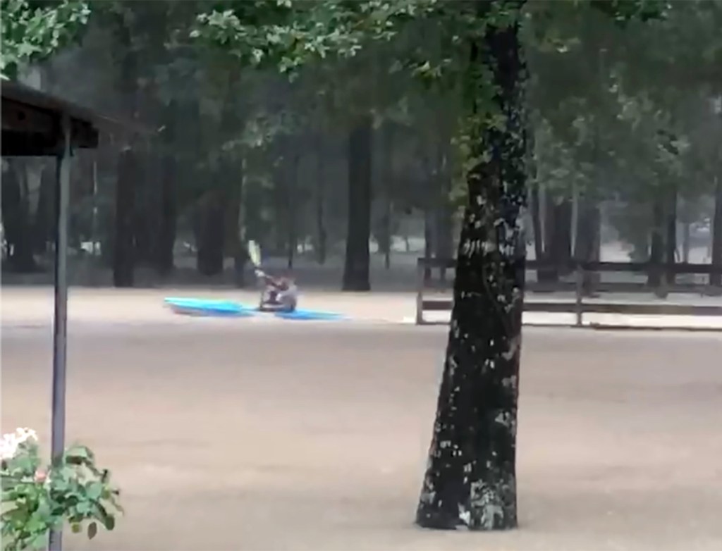
Imelda “Much, Much Worse”
Two years later, Imelda came along. And it was worse! Much, much worse. Kids were kayaking out on the street. That’s how bad it was.
Kayaking down the street in front of Fain’s house during Imelda
Rehak: Wow.
Fain: Archie had made it to work that morning and I called him and asked, “Do I need to start getting blankets and comforters to put in front of the door? And he says, “Honey, it’s water. Nothing’s going to stop it. If it’s coming in, it’s coming in.” And that’s when it came right up to the top step. It was within inches of coming in the house.
Video of Tropical Storm Imelda in Magnolia Estates courtesy of Rosemary Fain
Rehak: Did it undermine the corner of your house?
Fain: It messed up more than that.
Rehak: Catalog the losses for me. You lost some machinery in your wood shop.
Fain: We lost the jumper pump in our well house. Our septic system flooded. We had damage to the pier and beam foundation under our kitchen and dining room, where the foundation later collapsed – between Christmas and New Years of 2020. We had no idea how bad it was.
Part of damage caused by delayed collapse of one corner of house after Imelda
Corner of the house in kitchen that bore the brunt of Imelda’s floodwaters.
The pier-and-beam foundation and kitchen floor have to be completely replaced, as well as the bottom kitchen cabinets. We lost the motor and the heater to the hot tub, and the hot tub footings shifted, causing the hot tub to crack. We lost the motor to the pool. Our chicken and pigeon coops had to be demolished.
The neighbors behind us lost their sheep pens, but there were no sheep there at the time.
Neighbors sheep pens destroyed by Imelda.
And there’s now black mold in the well house and the garage shop.
Black mold in well house.
And, you know, by law we can’t sell this place with the black mold issues. So, what do we do?
We can’t afford to fix it and we can’t afford to move. This house is paid for. It’s our investment for retirement. But we can’t afford to fix what needs to be fixed and sell it.
Insurance doesn’t cover black mold.
Who would have thought we’d need flood insurance this far from the river? We have it now. But we didn’t when the floods hit.
Poorly Drained Soils Now Much Worse
Rehak: What can you tell me about the soils around here? Were they a factor?
Fain: It’s all clay-based.
Rehak: How does it drain?
Savage: Not well. These properties, if there’s a lot of water, they’ll hold it a good while to where it should percolate down. But it doesn’t. It cannot go through clay. Harvey deposited a lot of silt. Since Harvey, it just seems like the ground is constantly saturated even during the summer. And, if you dig down two … two and a half feet, it gets really, really messy.
Clay-based soil throughout area drains poorly.
Rehak: When you first moved here, did you go up Plum Grove Road and explore?
Savage: You could tell that it was a low-lying area.
Rehak: A lot of palmettos up there?
Savage: Yeah.
Loss of Thousands of Acres of Forest, Wetlands with Colony Ridge
Fain: The first time I came out here, it was a very pleasant, beautiful little drive. I was really impressed with the canopy of the trees and this whole area. And I’m telling you, it just is such a shame what it’s come to. It was all woods and all trees, and now it’s just nothing but tore up roads and mud.
Rehak: How did the changes coincide with development of Colony Ridge?
Fain: We never flooded before Colony Ridge.All the problems came after they started clearing trees. I remember all the logging trucks coming up and down Plum Grove Road. And then in 2017, Harvey hit and it was just horrendous.
Rehak: Do you feel that if the development hadn’t happened you would have been safer?
Fain: Definitely. It was scary. I mean, I wish we had taken our little flat bottom boat and tied it to that tree.
Slow Recovery and Then More Disaster
Rehak: How has the recovery been?
Fain: FEMA came out and they cut us a check for $357.
Rehak: $357!
Fain: And there is nothing available for Imelda. Project Recovery … I’ve called them twice, emailed them, and they haven’t responded at all.
Rehak: Are you in the City of Houston?
Fain: No, this is New Caney. But we’re in Harris County. The Liberty County line is about a block east.
Rehak: Tell me more about the damage to the corner of your house?
Fain: We just didn’t know the extent of the damage under our house after Imelda. We were just thankful that it didn’t get in. Then all of a sudden the whole corner of the house collapsed more than a year after the storm.
One day between Christmas and New Years of 2020, I walked into the kitchen to get dog food and I saw the whole corner of the house had collapsed. I went, “Oh, my God, oh, my God, Archie! There’s something going on in the kitchen.”
Close up of corner of the house that collapsed suddenly 15 months after Imelda.
We started pulling the flooring and floorboards away. I marked the wall and it’s gotten much worse since. We just had no idea what the extent of the damage was.
And now it looks like the window has closed for any assistance. So we’re having to repair this essentially on our own. Insurance will cover some of it, but they’re not going to cover all of it.
Refrigerator resides in front entry hall until repairs to kitchen can be made.
Disabled and Trying to Recover With One Income
Rehak: You’re disabled now?
Fain: Yes,I can’t work anymore.
Rehak: How has the COVID situation affected Archie’s job?
Fain: He’s been lucky. They cut him back to forty hours. There’s no overtime, but he’s been very fortunate to keep his job through all this.
Rehak: He’s the sole breadwinner. That has to make doing all these repairs tougher.
Fain: Oh yeah!
Rehak: Is there anything else around here, besides Colony Ridge, that may have affected flooding?
Fain: Not in our neighborhood. There are no new homes going in at all. It’s been built out for a long time.
Doesn’t Want to Move, But Can’t Afford to Fix
Rehak: If you could sell this house right now without taking too much of a loss on it, what would you do? Would you find another place in the country?
Fain: We’re so close to retirement, we don’t really want to move. But if we did, it would definitely be to a place in the country. And away from anywhere with a hurricane, tropical storm or any of that.
Rehak: Until you’ve gone through a few of them, it’s hard to imagine the destruction.
Fain: Well, I’ve been through two in five years now, Harvey and Imelda. I’d never been through one before.
Rehak: Did this place flood during Tropical Storm Allison?
Fain: No. Archie told me that he could see the trees leaning, leaning, leaning in front. And then he went to the back and he’d see them lean in the other direction. But it didn’t flood.
Rehak: What about during Ike?
Fain: Same thing. Wind, but no water near the house.
Advice to Others
Rehak: If you could tell the world one thing, what would it be?
Fain: If you see development going on around you or your neighborhood … get involved. Make sure they understand they’re being watched. If they don’t do things right with their drainage, it could ruin your neighborhood and ruin your home and ruin your life.
Posted by Bob Rehak on 1/17/2021 based on an Interview with Rosemary Fain and Archie Savage
1237 Days since Hurricane Harvey
https://i0.wp.com/reduceflooding.com/wp-content/uploads/2021/01/Fain-Kayak.jpg?fit=1200%2C916&ssl=19161200adminadmin2021-01-17 10:13:392021-01-22 19:06:30Rosemay Fain’s Harvey and Imelda Stories
Castle Hill Partners in Austin, the company that owns CH-B Kingland LLC, did not return phone calls re: its development plans. However, since tollway construction is moving from west to east, it would make sense to develop the western portions in Montgomery and Harris Counties before moving east into Liberty County.
Kingland’s 2017 sales brochure shows that almost half of the western section lies in Montgomery County along the San Jacinto East Fork. The remainder of the western section lies within Harris County. Both portions lie partially within the City of Houston’s Extra Territorial Jurisdiction.
Western section of Kingland shows a 41.3 acre detention pond, plus seven smaller ponds. But it’s unclear whether they will lie in the floodway or floodplain.
FEMA’s National Flood Hazard Layer Viewer shows the extent of the floodway and floodplains in that area.
Crosshatched area = floodway. Aqua = 100 year floodplain. Brown = 500 year.
I interviewed a family in that small development south of Kingland property that straddles the Harris/Liberty County Line and discovered that they flooded from the East Fork during both Harvey and Imelda. They live more than 1.5 miles from the nearest mapped floodplain. However, that could soon change when the new post-Harvey flood maps are redrawn.
Anyone downstream on the East Fork or Luce needs to keep a close eye on this one. It has the potential to further alter the hydrology of the watershed.
Posted by Bob Rehak on 1/11/2021
1231 Days since Hurricane Harvey and 480 since Imelda
The thoughts expressed in this post represent opinions on matters of public concern and safety. They are protected by the First Amendment of the US Constitution and the Anti-SLAPP Statute of the Great State of Texas.
https://i0.wp.com/reduceflooding.com/wp-content/uploads/2021/01/20210101-RJR_4417-1-e1610410584123.jpg?fit=1200%2C800&ssl=18001200adminadmin2021-01-11 18:25:112021-01-11 22:16:33Thousands of Acres in East Fork, Luce Bayou Watersheds to be Developed as Part of Kingland
The National Weather Service distinguishes between four major types of flooding: coastal, riverine, street and sheet flow. After flying over Colony Ridge on New Year’s Day, I would add a fifth: flooding by government neglect.
Despite dire predictions for the New Year’s Eve storm, the Plum Grove/Colony Ridge area in Liberty County only got about two inches of rain. Yet I saw hundreds of flooded lots. They were all in a development that:
Worst of all, when residents asked for help from their elected Liberty County officials, those officials berated and rebuffed them. They refused even to acknowledge problems in Colony Ridge.
Where It Starts
Irregularities that most banks would catch as part of a title search and survey during the mortgage application process never get caught here.
That’s because the developer targets a vulnerable population more likely to use Western Union money orders than banks. He offers them owner financing with low down payments and interest rates five times higher than the market.
These un-savvy buyers are so desperate to own a piece of the American dream that they wind up mired in one nightmare after another. Many speak English as a second language if they speak it at all.
A Two-Inch Rain
Trade those SVUs in for swamp buggies. Here’s what much of the development looked like 24 hours after two inches of rain fell on New Year’s Eve.
Note how the drainage stops in the middle foreground.Also note how it’s not infiltrating like the engineers said it would.Close up of home in first shot. At least the home didn’t flood although the four-wheelerand dining area did.Even if an owner builds up one part of his/her lot, it can flood another.Lot after lot flooded. Water would not sink in. The soils have a low rate of infiltration, not the high rate promised by LandPlan Engineering.Totally flooded lot. Note how drainage stops to left of driveway.Do-it-yourself repairs.But are they up to code?Former wetlands?
Targeting the Vulnerable
Most of these people never complain. The areas in Mexico and Central America where many came from may have conditions far worse. So what you see here may be an improvement for them.
Still, one can’t wonder whether – in its zeal to grow – Liberty County has turned a blind eye to conditions that violate its own regulations as well as human dignity.
Conditions such as these will take generations to improve. In the meantime, the County’s residents are in for decades of pain due to government neglect. Not just in Colony Ridge, but in neighboring communities such as Plum Grove and others farther downstream.
This developer has permanently altered the hydrology of the watershed in a way that increases flood risk for everyone.
And the county has lowered its standards in a way that will likely discourage investment from quality developers.
Posted by Bob Rehak on 1/3/2021
1223 Days after Hurricane Harvey and 472 after Imelda
The thoughts expressed in this post represent opinions on matters of public concern and safety. They are protected by the First Amendment of the US Constitution and the Anti-SLAPP Statute of the Great State of Texas.
https://i0.wp.com/reduceflooding.com/wp-content/uploads/2021/01/20210101-RJR_4809.jpg?fit=1200%2C800&ssl=18001200adminadmin2021-01-02 20:55:332021-01-03 16:57:55Flooding of the Fifth Kind: By Government Neglect
This is the confluence of Caney Creek (left) and the San Jacinto East Fork (right) one day after a New Year’s Eve storm dumped two inches of rain on the area, including Plum Grove and Colony Ridge. The rain turned Colony Ridge, to the right, into a river of mud again.
Looking north at the confluence of Caney Creek and the San Jacinto East Fork (right). The sediment coming from Colony Ridge is a man-made disaster in the making.Photo taken 1/1/2021.
Where the Pollution Came From
Picture courtesy of Michael Shrader, Plum Grove Resident, of Maple Branch near his home on 12/31/2020 as rains ended. Colony Ridge drainage ditch in Camino Real subdivision enters into Maple Branch and then into East Fork.
Colony Ridge Drainage Ditch. Photo taken 1/1/2021. Note lack of sediment controls such as grass, backslope interceptor swales, and silt fences. TCEQ has previously cited the development for piling dirt next to ditches like this and for lack of sediment controls, but has done nothing about it.See caption above.Likewise.And note how the piles of dirt on the left have almost completely eroded away.Photo 1/1/2021.
Posted by Bob Rehak on 1/2/2021 with thanks to Michael Schrader
1222 Days since Hurricane Harvey and 471 since Imelda
The thoughts expressed in this post represent opinions on matters of public concern and safety. They are protected by the First Amendment of the US Constitution and the Anti-SLAPP Statute of the Great State of Texas.
https://i0.wp.com/reduceflooding.com/wp-content/uploads/2021/01/20210101-RJR_4297.jpg?fit=1200%2C800&ssl=18001200adminadmin2021-01-01 22:03:192021-01-02 21:05:18Guess Which Way to Colony Ridge
Drainage reports for the controversial Colony Ridge development in Liberty County misrepresent soil types in a way that underestimate runoff by as much as 6X to 9X. As a consequence, the massive development’s ditches and detention ponds are undersized. That contributes to downstream flooding.
In addition, virtually all of the drainage reports supplied by the county in response to my FOIA (Freedom of Information Act) request were marked “preliminary” and many were missing. The Assistant County Attorney did not explain why. She said only that she had supplied all documents “responsive to” my request that the county had.
Let’s review soil types first.
USDA Findings Contradict LandPlan Engineering’s
U.S. Department of Agriculture (USDA) classifies soil into four groups (A, B, C, D) that represent rates of rainwater infiltration. GroupA has the highest rate of infiltration and D has the lowest. Think gravelly sand vs. clays.
When USDA analyzed soils in the Colony Ridge area, it found less than 2% in Group A. However, virtually all of LandPlan Engineering, PA reports used model inputs associated with soils in Group A. Hmmmm. Quite a contradiction. LandPlan is the engineering company for Colony Ridge that produced the drainage studies.
USDA says almost no Colony Ridge soils have the lowest rate of infiltration and LandPlan says almost all do.
Comparison of USDA Soil Survey and Landplan Engineering documents
Colony Ridge also has small percentages of soils in intermediate categories:
B = 2.3%
C = 1.2%
Finally, USDA shows some mixed soil types within Colony Ridge. For instance B/D or C/D. But a flood expert and professional engineer, who spoke on condition of anonymity, said that with mixed soil types, LandPlan should have classified them as Group D. “For all of the areas with B/D and C/D, you should assume that they are D because the soil is disturbed and probably compacted in some way.” So almost 95% of the soils should should be represented with a rate of infiltration equivalent to Group D.
Compacted soil on residential Colony Ridge lot. Note ponding water and damp soil at right. Note also the erosion under back fence next to ditch.Insufficient capacity of ditch contributed to erosion.
Soil Classification Consistently Off in One Direction
Liberty County supplied 39 drainage and construction documents in response to ReduceFlooding.com’s FOIA request. The soil classifications, as shown by the Curve Numbers in the reports all erred in one direction – the direction that favored the developer’s profits.
Almost 95% of the soils should be classified in the least porous group. But virtually allof the “curve numbers” reported by LandPlan Engineering are associated with the most porous group.
By classifying the soils as more porous than they actually are, the engineers could claim there was less runoff and therefore reduce the size of ditches. Likewise, they could reduce or eliminate detention ponds.
What Curve Numbers Mean
Curve Numbers (abbreviated as CN in drainage reports and construction docs) numerically represent the rate of rainwater infiltration. They correlate primarily to soil groups, but also land use and surface conditions. For instance, after soil is paved with concrete, the curve number goes up (indicating less infiltration).
Excerpt from Bella Vista Drainage Report. Note Curve Number for pre-existing conditionsassociated with Group A soils, i.e., those having the highest rate of infiltration.
USDA’s soil report for Bella Vista Section 1 shows that the soils are Group C (69%) and Group D (31%). According to USDA and the flood expert/engineer above, the Curve Number used to calculate detention requirements for the “developed condition” should have been closer to 85. But the Curve Number on which the detention is based is 56 (see below) – a number associated with Group A soils. Note: this is a subset of the larger report for Colony Ridge discussed above.
Bella Vista Section 1 shows post-development Curve Number of only 56, associated with the highest rate of infiltration.
Importance of Accurate Curve Numbers
While Group A can absorb .3 to .45 inches of rainfall per hour, Group D absorbs only 0.00 to 0.05 inches per hour. Had LandPlan used the correct values, they would have had to accommodate 6X to 9X more rainfall.
Texdot
That would have required building larger ditches and detention ponds. But by using the Group A numbers, they could claim:
Floodwaters were soaking in.
Their roadside ditches could hold runoff.
No, fewer, or smaller detention ponds were necessary.
This suggests that LandPlan altered model inputs to achieve the desired output. The flood expert above called LandPlan’s Curve Numbers, “just plain wrong.” “Soils like that just don’t exist in this area,” he said.
The Berg-Oliver report was NOT one of the documents supplied by Liberty County. I found it attached to an affidavit by the former Liberty County Engineer in a lawsuit between the ex-Mayor of Plum Grove and the developer of Colony Ridge.
Role in Downstream Flooding, FM1010 Washout, Erosion
Plum Grove residents report increases in the severity and frequency of flooding since Colony Ridge started clearing land. Water accumulates faster and peaks higher, they say, because of the loss of trees and wetlands. But the extra runoff that engineers have not accounted for in their calculations makes those problems even worse. That’s because Colony Ridge ditches and detention ponds can’t retain the extra runoff.
Mischaracterization of soil types likely also played a role in the washout of FM1010.
During Harvey, Colony Ridge drainage ditches discharged so much water into Rocky Branch that the stream then overtopped and destroyed FM1010. The blowout worsened during Imelda. No one has repaired it yet.
Finally, the “tractive” force (power) of rapidly moving water through undersized ditches accelerated erosion. Downstream, the eroded sediment built up and forms sediment dams that back water up, flooding additional homes in Plum Grove, or near the San Jacinto East Fork and Luce Bayou.
“Preliminary” Plans
My Freedom of Information Act (FOIA) request to Liberty County asked for ALL drainage analyses/surveys and construction plans for Colony Ridge subdivisions. However…
Virtually all of the plans that Liberty County supplied were marked “preliminary.”
None was marked final or approved.
Many were missing altogether.
NOT ONE bore the signature, stamp, or comments of the Liberty County engineer or his agent, LJA Engineering.
The 39 reports/surveys and plans are too large to post here; they comprise 1.5 gigabytes.
Liberty County has yet to clarify why so many of the plans are named “preliminary” or were missing. However, the Assistant County Attorney did verify that she supplied all Colony Ridge documents that pertained to my request.
Missing Documents
Here is a list of NINETEEN missing documents:
Missing Drainage Plans/Analyses (16)
Bella Vista – Section 2
Camino Real – All Four Sections
Grand San Jacinto – All Five Sections
Montebello – All Four Sections
Sante Fe – Sections 1 and 2
Missing Construction Plans (3)
Camino Real – Sections 1 and 2
Grand San Jacinto – Section 2
The problems in the 39 documents that Liberty County DID supply make one wonder what’s in the 19 they DID NOT supply.
Fallacy of Government Oversight
Not only are many documents missing, the ones Liberty County does have appear to be based on false assumptions about soil types.
I’m told by reputable engineers and floodplain administrators that this problem is common. Developers can always find engineers willing to sell favorable opinions – much like junkies know how to find doctors willing to write prescriptions for oxycodone.
Most people don’t have the expertise to evaluate reports like LandPlan’s. The hired guns know it and count on it. Cities and counties could hire engineers to thoroughly check these plans, but they don’t … for several reasons:
Awareness of this problem is low.
There’s no public pressure for counties to hire plan-checking engineers.
Developers make huge political contributions.
Floods often happen years after buildout of subdivisions.
By the time people flood, it’s too late. The damage has already been done. And the people responsible are often long gone.
Posted by Bob Rehak on 12/26/2020
1215 days since Hurricane Harvey and 464 since Imelda
The thoughts expressed in this post represent opinions on matters of public concern and safety. They are protected by the First Amendment of the US Constitution and the Anti-SLAPP Statute of the Great State of Texas.
During my life, I’ve explored 49 states. But the state I choose to call home is Texas, and there’s no place I’d rather live in Texas than the Lake Houston Area. That’s in large part due to our proximity to nature and our fierce commitment to preservation.
This country has a lot to love. But if you love being close to nature, jobs, the arts, education, transportation, and medical care, no place I’ve found offers a better balance than the Lake Houston Area.
Our Unique Selling Proposition
You can find everything in that list above in every major metropolitan area in the country…with one exception – nature.
Sure, when you’re in other cities, you can get in your car and drive several hours to enjoy nature. Here, it’s outside your back door and down the block. Along hundreds of miles of greenbelts that wind through your neighborhood and along waterways. In the country’s largest urban nature park – the 5,000-acre Lake Houston Wilderness Park. And in the national forests and wildlife refuges that surround us.
Looking north toward Lake Houston Wilderness Park. It’s six times larger than New York’s Central Park.Looking south along the East Fork toward Lake Houston in background over Kingwood’s East End Park, home to more than 140 species of birds, many of them threatened or endangered.
The Value of Nature
Nature is more than a place to explore. It’s a natural sedative. It’s restful. It quiets the soul and the mind. It sustains sanity. It’s an evolutionary anchor in a fast-changing society. The womb of the world. A protective refuge from conference reports, tax forms, sales quotas, deadlines, and performance reviews. It’s a place to just breathe, bask, and be.
Property Rights and Profit
To developers and sand miners who shout “property rights” in their quest for profits, I would say, “Go ahead, develop your land as you wish. Just realize what you’re selling. Don’t destroy the uniqueness that makes your property worth more than it otherwise would be if you cut down the forest, filled in the wetlands, and turned natural streams into concrete ditches.
“Hey, Dear. Let’s take the kids for a walk along the ditch. I hear the sand mine’s water turned neon green! It’ll be fun. What do you say? We can bring the dog. He’ll find plenty of dead frogs to eat.”
Yeah, people will commute an extra hour, and pay a premium to live ten feet from noisy neighbors and that!
Colony Ridge development east of Plum Grove, TX.Not long ago, this was all forests and wetlands.It’s less than three miles from Lake Houston Wilderness Park.Water at Hallett Mine on West Fork. Photographed 12/7/2020.Looking west up the West Fork of San Jacinto toward 20 square miles of sand mines. Photo taken in September. Water flows toward camera and then left out of frame into Lake Houston,
Plea for Preservation
So, developers and miners, please think carefully before exercising your property rights. Once the forest is gone, it’s gone forever. You will alter the watershed inalterably. Preserve the wetlands that keep surrounding areas from flooding. Preserve the “brand” you’re selling. You’re not just selling sticks and bricks. You’re selling safety.
Preserving nature preserves profit potential for generations to come.
Posted by Bob Rehak on 12/23/2020
1212 Days since Hurricane Harvey
The thoughts expressed in this post represent opinions on matters of public concern and safety. They are protected by the First Amendment of the US Constitution and the Anti-SLAPP Statute of the Great State of Texas.
https://i0.wp.com/reduceflooding.com/wp-content/uploads/2020/12/Colony-Ridge-and-Lake-Houston-Park-copy.jpg?fit=900%2C1200&ssl=11200900adminadmin2020-12-23 12:23:172020-12-23 12:38:58Preserve What Makes Lake Houston Area Unique
In 2016, one of the owners of the Colony Ridge Development in Liberty County tried to sue the former Mayor of Plum Grove for defamation. The developer alleged that the mayor bad-mouthed his development while making false statements. The judge ultimately dismissed the suit.
But as part of the lawsuit, Louis W. Bergman, III, PE, provided a glowing affidavit, lauding the development. Bergman served as the County Engineer and Flood Plain Administrator at the time. He also issued licenses and permits for Liberty County. In that regard, he reviewed all plat submittals for compliance with Texas statutes and Liberty County’s subdivision rules.
What a Difference Four Years Makes
Below are some quotes from Bergman’s affidavit. I took all the pictures from a helicopter on 12/7/2020 while flying over Colony Ridge. They show how quickly conditions have deteriorated there.
“In my experience, Colony Ridge has been one of the best land developers in Liberty County.”
“I respect Colony Ridge Development … and their business because they have earned my respect by representing themselves with integrity and working to build quality developments.”
Louis W. Bergman, III, PE in Paragraph 15
“In my opinion, Colony Ridge Development has built some of the best infrastructure for residential neighborhoods in Liberty County and Colony Ridge Development’s lots do not create a health, safety, or welfare threat to Liberty County.”
Louis W. Bergman, III, PE in Paragraph 11
“I have heard [the former mayor of Plum Grove] make statements that Colony Ridge Development has violated environmental laws, such as regulations by the Texas Commission on Environmental Quality, and I disagree with these statements and believe they are false statements.”
Liberty County’s own Strategic Plan cites the need to improve drainage infrastructure and building codes. But it doesn’t mention Colony Ridge by name.
Likewise for Liberty County’s Hazard Mitigation Plan. It discusses the need to improve a variety of safety issues such as drainage; street lighting; electrical service; communications infrastructure; high percentages of mobil and self-built homes; emergency access; and flooding … in every city in the county … all without mentioning Colony Ridge by name.
So maybe Bergman was right after all. Maybe this IS the best that Liberty County has to offer.
But I suspect the judge who dismissed the lawsuit, might take exception.
Posted by Bob Rehak on 12/21/2020
1211 Days since Hurricane Harvey and 459 since Imelda
The thoughts expressed in this post represent opinions on matters of public concern and safety. They are protected by the First Amendment of the US Constitution and the Anti-SLAPP Statute of the Great State of Texas.
https://i0.wp.com/reduceflooding.com/wp-content/uploads/2020/12/20200616-RJR_4084.jpg?fit=1200%2C800&ssl=18001200adminadmin2020-12-22 21:16:002020-12-22 21:39:36“One of the Best Land Developers in Liberty County”