May 1, 2024 – Even as East Fork homes are flooding, the National Weather Service has issued another Flood Watch for the region.
Monday’s Storm Brings Wednesday’s Flood
The stormwater from last Sunday night/Monday morning that’s flooding homes near the East Fork San Jacinto could get reinforcements tonight. Another powerful storm is approaching and will collide with moisture laden air from the Gulf later day.
That caused the National Weather Service to issue another flood watch from 10 PM this evening until Thursday evening for Houston and Harris County.
That same NWS bulletin also says that a flood warning remains in effect for the East Fork San Jacinto near New Caney affecting Liberty, Montgomery and Harris Counties.
Jeff Lindner, Harris County’s meteorologist, warned in his midday report that “Widespread amounts of 2-5 inches are likely with isolated totals of 6-9 inches. High hourly rainfall rates will be likely on the order of 2-4 inches which will produce rapid onset flash flooding.”
Lake Conroe and Lake Livingston Already Taxed to Max
The additional rainfall could overburden already overtaxed watersheds. “There is no capacity at either Lake Livingston or Lake Conroe,” said Lindner. “Additional inflows and run-off will have to pass through the dams’ floodgates.”
Although Lindner expects the heaviest rains to stay north of Harris County, “There is some potential that some of the heavy rainfall reaches into northern Harris County overnight,” he added.
If so, the storm could impact Spring, Cypress, Little Cypress, and Willow Creeks as well as the tributaries in northern Waller and southwestern Montgomery Counties, such as Lake Creek.
Lindner says significant rises will be possible depending on the rainfall amounts and patterns. Flash flooding will be likely where heavy rains occur.
That could deal a devastating blow to homes already flooding along the East Fork.
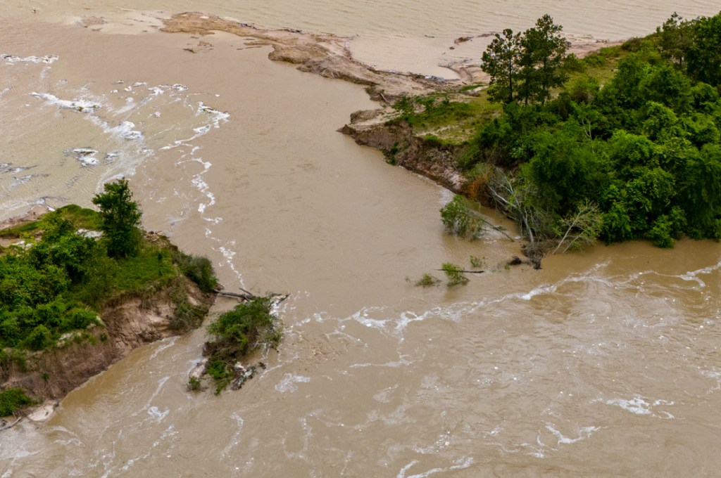
East Fork Photos Taken Morning of Mayday Flood
Pictures taken this morning between 9 and noon showed roads flooded out and many homes and vehicles already underwater.
TXDoT closed FM1485 at the East Fork/Montgomery County line.SH99 on left, FM1485 on right.
Streets close to the river also flooded.
Looking S. Casey Road on left flooding from East Fork on right.Home with flooded vehicles and heavy equipment at Casey and Spaulding.Flooded homes at Casey and Green. Cypress Hollow just N of SH99.
I took more than a hundred photos like these this morning. Some people were lucky with the water stopping just feet from their homes. Other people were not so lucky. They will need help.
Colony Ridge, Plum Grove and FM2090
Farther north, I explored Colony Ridge and Plum Grove near FM2090.
One of the main entrances to Colony Ridgewhere it approaches Plum Grove Road
The water there was already starting to recede. But still, many roads were barely passable. Most smaller vehicles did not brave the water.
Opposite angle, same intersection. Unable to see the sides of the road, traffic tried to stay close to the centerline to stay out of the ditches.Looking NW over East Fork. FM2090 was still passable, but water lapped at the bottom of the bridge. The East Fork completely flooded the abandoned sand mine (upper right) and swept sediment out of mine.
Ironically, even though I could see my way out of Colony Ridge (from the air), I could not get to FM2090 on the ground because of floodwaters. I had to drive south to SH99 to return home.
Dunnam Road Boat Launch
Back in Kingwood, I called a friend on Dunnam Road. She said her boat launch flooded and that water was lapping at the first house coming up the hill.
Dunnam Road boat launch.Note water surrounding house adjacent to boat dock. Luckily it did not flood and water is receding as of 4PM.This young man appeared to be making the most of the flood by giving his daughter a fishing lesson.A neighbor told me he’s been doing that since she was born!
Posted by Bob Rehak on May 1, 2024
2437 Days since Hurricane Harvey
https://i0.wp.com/reduceflooding.com/wp-content/uploads/2024/05/20240501-DJI_20240501090820_0035_D.jpg?fit=1100%2C619&ssl=16191100adminadmin2024-05-01 16:35:032024-05-01 16:35:05East Fork Homes Flooding, Another Flood Watch Issued
(Updated with more Subdivisions/Streets at 9PM Tuesday) As yesterday’s heavy rains work their way downstream, the National Weather Service’s (NWS) Advanced Hydrologic Prediction Service forecasts that the East Fork at FM1485 will rise 15 feet in the next 24 hours.
As of noon Tuesday, NWS said the river had already reached the “Action Stage” at 56.85 feet. NWS predicts it will reach 71.9 feet by tomorrow at noon. “Major flooding” at that location begins at 69 feet.
Jeff Lindner, Harris County’s meteorologist, says, “Many of the structures in this area have been elevated, however isolated homes that remain on the ground will be subject to flooding at these levels.”
FM1485 will be under several feet of water. Flows may even approach the deck of the Highway 99 bridge!
Subdivisions and Streets that Could Be Affected
Lindner specifically warned about flooding that could affect the following subdivisions and streets.
Magnolia Point (West end of Commons of Lake Houston)
Opal Way
Diamond
Mendencino
Lassen Villa
Glen
Magnolia
Hill
Calvins
Collins
Calaveras Creek
Flooding of streets is likely. Elevated homes will be cut-offSome structure flooding is possible for any homes on the ground in this area.
South of FM 1485 (east side of the river):
Spalding
Green
Jett
Casey
Some structure flooding is possible for any homes on the ground in this area.
Idle Glen subdivision:
Brookside
Chinquapin
River Side
E. San Jacinto
Glenwood
Dipping
Idlewild
Lazy Creek
Almost all of the homes in this area are elevated, but will be cut-off. Any homes on the ground will be flooded.
Northwood Country Estates:
Flooding of streets is likely. Elevated homes will be cut-off.
Disher
Bounds
Thomas
Davidson
A new 553-acre Friendswood development called Sila is in this area.
River Terrace:
Flooding of the following streets is likely. Elevated homes will be cut-off.
River Terrace
Elm
Pine
Cherry Laurel
Holly
Cypress
Cypress Point:
The following streets will be flooded (closest to the river). Elevated homes will be cut-off.
Blue Lake
Oak Knoll
Wild Oak
Birchwood
The East Fork should also rise 10-15 feet at FM2090.
East Fork at Cleveland
Farther upstream at Cleveland, the East Fork has already peaked and is beginning to recede after only reaching a moderate level of flooding.
As of noon 4/30/24, the East Fork at Cleveland was at a moderate flood stage.
Structure Flooding In Kingwood NOT Expected
Lindner added that, “Flooding will occur in the low lying areas of Kingwood that back up to the East Fork of the San Jacinto River. This is mostly all non-developed lands near the river or back yards with bulkhead that front the river. Structure flooding is NOT expected in Kingwood.”
Meanwhile, at as of noon on 4/30/24, NWS predicts the West Fork will not flood.
Noon, 4/30/24
View Real-Time Inundation Mapping
To view Real-Time Inundation Mapping, go to www.harriscountyfws.org and click “inundation map” on the left side.
Trinity River Also Flooding Badly
The Trinity River at Liberty is about to see major flooding through Sunday. The Trinity is a separate watershed. It will not affect Harris County.
As of noon, 4/30/2024
Other Flooding
Fourteen gages show various streams and creeks in the region are at or near flood stage.
https://i0.wp.com/reduceflooding.com/wp-content/uploads/2024/04/EastForkat1485.png?fit=600%2C465&ssl=1465600adminadmin2024-04-30 14:02:482024-04-30 21:28:23East Fork Predicted to Rise 15 Feet in Next 24 Hours
4/29/24 – The rainfall distribution in last night’s storm was very uneven. It ranged from a tenth of an inch in some places to more than 10 inches in others.
Totals to the north and east of Houston approached 8-10 inches in places. But most of Harris County received less than 2 inches.
Regardless, the heaviest rainfall in the upper reaches of the East Fork San Jacinto watershed will migrate downstream in the next 2-3 days and cause flooding in low-lying areas near New Caney. The West Fork should only be moderately affected.
After three hours of driving around this morning, all ditches and minor streams that I saw appeared to be within their banks.
Very Uneven Rainfall Distribution
The farther north and east you went, rainfall increased. The gage at US59 and the West Fork received only 1.76 inches.
My rain gage by Kingwood High School recorded 3.11 inches. And a friend who lives by the Montgomery County line recorded a little more than 4 inches.
The Trinity River Authority recorded 10.92 inches on Caney Creek at a small town called Fryday north of Lake Livingston. That gage recorded a whopping 6 inches in one hour between 8 and 9 PM last night.
A gage in Mont Belvieu recorded almost 9 inches. Almost 5 inches of that fell in one hour between 2 and 3 AM.
Most of the higher totals occurred in watersheds that will not drain directly into Harris County. At 1PM on Monday, only six gages in and around the county showed danger signals (meaning a stream was in danger of coming out of its banks).
Most Streams in Banks
The good news: Only one stream at this hour is in danger of coming out of its banks upstream from Lake Houston. That’s Peach Creek near 2090. Peach Creek forms the western boundary of Lake Houston Park.
The bad news: SJRA is releasing almost 10,800 cubic feet per second from Lake Conroe at noon due to heavy rains north of the lake.
From SJRA.net at noon 2.29.24Rainfall totals north of Lake Conroe and around Lake Livingston. From Harris County Flood Warning System, noon 4.29.24.
Farther south, however, totals dropped off rapidly. Parts of western and southern Harris received only a tenth of an inch!
From Harris County Flood Warning System as of 1PM 4/29/24
Flood Forecasts
Because of the rainfall distribution, you need to look upstream from where you are to see whether your area is in danger of flooding. You also need to factor in travel time for the floodwaters. Due to the distance of the heaviest rainfall, flood impacts will be delayed.
Lake Houston
Inflows from the East Fork, Peach and Caney Creeks, and Luce Bayou will result in a rise in the lake level Tuesday into Thursday. Elevated water levels and flows will be likely through Lake Houston for much of this week, according to Jeff Lindner, Harris County Meteorologist.
West Fork San Jacinto
Lindner expects no flooding at this time…again due to the very uneven rainfall distribution.
Much of the rainfall overnight fell above (north) of Lake Conroe. That will buffer some of this inflow. Additionally heavy rainfall largely missed Spring and Cypress Creeks and only modest amounts occurred along middle and upper Lake Creek. So, additional inflows below Lake Conroe look to be minimal.
The river is not expected to reach flood stage at US 59. However, you should continue to monitor the situation for any changes.
This morning, the West Fork was up slightly. Large amounts of foam and debris were moving downstream. But even low-lying areas such as River Grove Park and the area under the US59 bridge were well above water.
River Grove Park Boat Dock area, around 10AM on 4.29.24West Fork at US59 looking S toward Houston. At 10AM, the river was still well within its banks.
That could change by tomorrow morning.
Worst Flooding Will Be on East Fork at New Caney
A significant rise in the East Fork will start on Tuesday into Wednesday. The river will rise just below major flood level later this week.
At the forecasted levels, FM 1485 will be impassable on the west approaches and several roads downstream of FM 1485 will become flooded and impassable on the west side of the channel. Additionally low lying areas along the river in River Terrace will experience high water, according to Lindner.
Stay tuned for more updates tomorrow and Wednesday.
Posted by Bob Rehak on 4/29/24based on information provided by Harris County Meteorologist Jeff Lindner
2435 Days since Hurricane Harvey
https://i0.wp.com/reduceflooding.com/wp-content/uploads/2024/04/image001-1.png?fit=597%2C463&ssl=1463597adminadmin2024-04-29 14:35:512024-04-29 17:05:57Storm Report: Flooding Delayed Because of Rainfall Distribution
A breach at the giant Hallett Mine on the San Jacinto West Fork that began in late January or early February is still open and expanding.
Two Pairs of Pictures, Two Weeks Apart
I first reported the breach on April 10. Below are pictures taken then and today.
Hallett Breach, April 10, 2024Hallett Breach, April 24, 2024
In the pictures above, note the difference in the river bank on the left. It appears much more eroded. Also note the freestanding tree in the water on the right in the second photo that is not visible in the first.
Comparison of these wider shots shows more differences.
Hallett Breach, April 10, 2024Hallett Breach, 4/28/2024.
The first shots in each pair were taken when the water was up due to heavy rains upstream. The second shots were taken when the river was at its normal level (57 feet at SH99 as opposed to 66 feet).
In the shot immediately above, note the lack of vegetation on the sidewalls of the pond. That’s one indication that the height of water in this pond was much higher at one time.
Google Earth Image
This image from Google Earth shows water draining out of the pond on February 19.
Hallett Breach in satellite image from Google Earth taken on 2/19/2024shows silty water pouring out of the mine.
Impacts on River
One boater I interviewed for this post last Wednesday when SJRA was releasing 530 cubic feet per second from Lake Conroe said he could normally get all the way to Conroe in his flat bottomed boat at that flow rate. But on that day, he was frequently hitting bottom.
This is consistent with the experience of boaters launching farther downstream in River Grove Park. There, the river depth is now just 1-2 feet in places. And that’s after it was dredged just four years ago.
The Kingwood Service Association is studying ways to keep its boat launch open. But the need for dredging is becoming more expensive and frequent.
I should add in fairness that the river creates a fair amount of erosion on its own and that Hallett isn’t the only mine on the West Fork with breaches in its dikes.
It is, however, the largest mine by far and has a history of dumping its waste into the West Fork. Searching on the keyword “Hallett” in this website reveals 30 posts that include references to the controversial mine.
It has now been approximately three months since the breach.
Posted by Bob Rehak on 4/28/2024
2434 Days since Hurricane Harvey
The thoughts expressed in this post represent opinions on matters of public concern and safety. They are protected by the First Amendment of the US Constitution and the Anti-SLAPP Statute of the Great State of Texas.
https://i0.wp.com/reduceflooding.com/wp-content/uploads/2024/04/20240428-DJI_20240428150341_0458_D-2.jpg?fit=1100%2C778&ssl=17781100adminadmin2024-04-28 17:35:382024-05-14 17:23:32Breach at Hallett Mine Expanding
In 2019, Montgomery County posted a minor update to a drainage criteria manual first published in 1989. However, in February 2024, the County published a draft of a comprehensive new update to the county’s drainage standards. The 124-page manual is a thorough rewrite that brings the County’s standards up to date and more in line with surrounding areas.
Some Major Revisions
Because the manual is targeted to engineers, it gets very complex very fast. However, it is obvious that Montgomery County took pains to remedy some of the shortcomings of the past. For instance:
Section 1.4
Addresses approved hydraulic modeling software packages. It’s not that the packages are revolutionary. It’s that it requires the use of industry-standard packages. The previous manual did not; it only recommended certain packages. According to one flood plain manager I talked to, this will greatly facilitate the checking of plans. (See Page 10.)
Section 1.5
Specifies “No Adverse Impact” from drainage. The County says, “…one property owner should not be allowed to adversely affect the rights of other members of the community.” This protects the rights of neighboring property owners and also protects the natural systems that provide flood mitigation benefits to the community. It specifically prohibits flooding of downstream neighbors.
Significantly, No Adverse Impact includes impacts other than water surface elevation. They include peak flow, velocity and flow type. (See Page 11.)
Section 2.2.1
Mandates use of certain roughness coefficients for use in different situations. This affects calculations for the speed of runoff. They are critical for determining how fast and high flood peaks will build. In the old manual, calculating the roughness was somewhat subjective. (See pages 16, 48 and 50.)
Section 3.3
Unifies the discussion of erosion controls (both structural and natural) in great detail.
Section 5.3
Requires more storm drain inlets along roads by reducing spacing to 500 feet from 750.
Section 5.4
Requires land plan and street layout changes to improve stormwater conveyance in 100-year events.
Section 6.2
Stipulates that all projects shall mitigate and attenuate the runoff for 5-, 10- and 100-year storm events.
Section 6.3
Requires detention for all proposed developments, regardless of size. It also specifies how the amount will be calculated, and minimum rates (acre feet per acre) for different sizes and types of developments. In addition to other things, it specifies that post-development runoff rates shall not exceed pre-development rates.
Section 7.2
Discusses acceptable floodplain mitigation measures. For instance, “Natural channel clearing to reduce friction losses within the floodplain shall not be allowed as an acceptable floodplain mitigation measure.”
Maintenance
The name and contact information for the entity responsible for maintenance of detention facility, channels, and storm sewers must be listed on construction drawings under the proposed guidelines. “Maintenance shall be the responsibility of the private property owner and not the County,” says the draft manual in various sections.
Still Doesn’t Completely Embrace Harris County Recommendations
From a public protection standpoint, the changes in the new drainage criteria manual may not be revolutionary, but they are a vast improvement according to several hydrologists and a flood forecaster I consulted.
Does it incorporate the minimum drainage standards that Harris County urged surrounding counties to adopt after Hurricane Harvey? Some, but not all of them.
The table below summarizes Harris County’s recommendations and the recommendations reflected in Montgomery County’s draft drainage criteria manual.
Montgomery County already uses Atlas 14 rainfall rates as the basis for all its drainage calculations. That will continue if the new draft drainage criteria are adopted. That’s great.
Even better though is this news. With a few minor exceptions, Montgomery County will require a minimum detention rate of .55 acre-feet per acre. It’s not quite up to Harris County rates, but it’s WAAAAAY better than nothing.
Previously, many developments used hydrographic timing surveys to avoid building any stormwater detention at all. But if adopted, the new drainage criteria will prohibit the use of such surveys. They will require detention for all new developments.
Timing surveys encouraged developers to get their water to bayous as fast as they could, which built flood peaks faster and higher for people downstream.
Fill, Finished-Floor Elevations
Sadly, Montgomery County’s draft drainage criteria would allow fill to be brought into the 500-year flood plain. In extreme events, this could constrict the width of the floodplain and cause a rise in flood levels.
The proposed finished-floor-elevation requirements in MoCo are also less stringent than Harris County. That, however, is the sort of thing more likely to affect Montgomery County residents than those downstream.
I remember owning a new home in the Dallas area back in the early 1980s that was supposed to be 1-foot above the 100-year flood plain. Within three years, it flooded. A new survey by the Army Corps of Engineers found that because of insufficiently mitigated upstream development during those three years, we were actually ten feet below the 100-year floodplain instead of a foot above it.
Montgomery County is also revising its subdivision regulations. They may have more to say on this topic.
Complete Manuals and Summary of Drainage Revisions
To see the old and proposed new drainage criteria manuals, see these links:
Harris County and the Houston area are receiving $863 million from the U.S. Department of Housing and Urban Development (HUD) via the Texas General Land Office (GLO) for disaster relief and flood mitigation. So, on Thursday, April 25, 2024, GLO Commissioner Dr. Dawn Buckingham met with a group of Lake-Houston-Area leaders to discuss the area’s flood mitigation needs.
The meeting, arranged by State Representative Charles Cunningham, also included Director Tina Petersen of the Harris County Flood Control District (HCFCD); Director Thao Costis of Harris County Community Services (CSD); Humble Mayor Norman Funderburk; and Dustin Hodges, Chief of Staff for City of Houston Council Member Fred Flickinger.
(L to R) Dustin Hodges; Tina Petersen; Thao Costis; Dr. Dawn Buckingham; Rep. Charles Cunningham; Norman Funderburk; Alice Rekeweg; Scott Elmer, HCFCD; and Kathleen Jordan.
Projects Vie for Funding
As reported on 4/23, Buckingham was in Houston to discuss Disaster Relief and Mitigation projects totaling $863 million. But there are more deserving projects than money to fund them all. So Buckingham, her team, HCFCD and CSD met with area leaders to discuss needs.
The GLO administers the distribution of HUD funds in Texas. Among Lake Houston Area projects discussed for funding were:
No commitments were made at the meeting, but the mood was positive and everyone left smiling.
Buckingham is still collecting information. She listened attentively, asked probing questions and left with a better understanding of the area’s needs.
Splitting the Woodridge Basin into two phases helps ensure that at least one compartment will get funded and provide enough mitigation to let the Taylor Gully Channel Improvements move forward.
Other Topics
Several other topics came up toward the end of the hour-long meeting. They included sedimentation, dredging, and the need for sand to nourish beaches along the Texas coast. The GLO needs sand to replace eroding beaches…and this area needs to remove sand collecting in streams and Lake Houston.
That raised the tantalizing possibility of collaboration for mutual benefit and solving two problems at once.
More news to follow.
Posted by Bob Rehak on 4/26/24
2432 Days since Hurricane Harvey
https://i0.wp.com/reduceflooding.com/wp-content/uploads/2024/04/Buckingham-Meeting.jpg?fit=1100%2C413&ssl=14131100adminadmin2024-04-26 11:38:552024-08-01 16:41:46Area Leaders Meet with GLO Commissioner Buckingham
Harris County Precinct 3 Commissioner Tom Ramsey’s Office will host a meeting about local infrastructure at Kingwood High School tonight. The meeting will include representatives from the City of Houston, San Jacinto River Authority, Congressman Dan Crenshaw’s office, and Harris County Flood Control District.
6:30-8:00 PM
The infrastructure meeting will follow an open-house format. After brief remarks, residents will be free to mingle with representatives from the various organizations at tables set up throughout the room. So you can come and go as you please.
This will give everyone a chance to discuss issues in depth. See details below.
Focus on Infrastructure
Infrastructure covers a lot of territory. Drainage. Roads. Parks. Water. And more.
City of Houston District E Council Member Fred Flickinger addressed a group of local executives at the Kingwood Country Club this morning. He covered a wide range of topics, both in his talk and during Q&A. They included the status of five flood-related topics for the Lake Houston Area:
New Gates for the Lake Houston Dam
Seasonal Lake Lowering
Additional dredging in Lake Houston
Kingwood Diversion Ditch expansion
Last weekend’s flooding on Northpark Drive
Flickinger addressing the Kingwood Executive Group at the Kingwood Country Club on 4/24/24
Floodgate Construction Could Start in ’25 or ’26
Within two sentences of standing up, Flickinger got straight to the subject of flooding and new, bigger floodgates for the Lake Houston Dam. He said, “Obviously, the big thing is getting additional gates. That is currently pending a FEMA review and approval.”
He continued, “We have about $150 million secured for those. Much of that has come via Rep. Dan Crenshaw’s office. Also the State, thanks to Representatives Dan Huberty and Charles Cunningham, and Dave Martin, my predecessor. Stephen Costello [the City’s Flood Czar] has also all done great work. They’ve all really done yeomen’s jobs getting money for the dam gates.”
Looking S.New gates will be built in the earthen portion of the dam to the left of the four small gates you see now.
“We’re looking at construction probably in late 2025 or sometime in 2026,” said Flickinger. “That’s obviously the biggest key to reducing flooding.”
Flickinger also said that he believes the current Mayor remains committed to the project.
Seasonal Lake Lowering
Regarding lowering Lakes Houston and Conroe, Flickinger said the City and SJRA have moved to an event-driven strategy rather than a seasonal one. Automatically lowering the level of Lake Conroe twice a year to reduce flood risk in the Lake Houston Area generated pushback from Lake Conroe residents.
For some time now, the politically divisive strategy has been replaced by an “as-needed” lake-lowering policy in one or both lakes depending on where and when rain falls.
However, the “as needed” policy requires precise forecasting. And several times lately, rain has shifted at the last minute. Ironically, that supports the need for bigger gates that release water faster. They can create extra storage in Lake Houston while still reducing the lead time needed, so forecasters can be absolutely certain of the need to lower the lake.
After all, that’s the drinking water supply for more than 2 million people. You don’t want to lower it needlessly if it won’t be refilled right away.
More Dredging on Tap
Flickinger next addressed the need for more dredging. He said that the City is currently removing another 800,000 yd³ of sediment between Kings Point and FM1960.
“Again, funding for that largely came from Rep. Dan Crenshaw’s office,” he said. “Some people in the government questioned whether that was Harvey-related sediment. But we got the funding! And dredging has started. So that’s a really good thing.”
Diversion Ditch/Walnut Lane Bridge
“The next issue with flooding,” said Flickinger, “is really the Kingwood Diversion Ditch.” The ditch cuts south from St. Martha’s Catholic Church to River Grove Park through the western portion of Kingwood.
“The Walnut Lane Bridge has about a fourth of the surface area below it that the Kingwood Drive and North Park Bridges have. Because of that, it works somewhat like a dam. Crenshaw just secured $4 million to address that, but we have got to have a cost/benefit ratio of one or greater, which will be a challenge. So, we’re working on that.”
Looking north along Diversion Ditch. Notice how it narrows under the Walnut Lane Bridge.
“And that money probably won’t become available for another six months. Hopefully, we can get that cost/benefit analysis to where we need it by then and use that money to rebuild the Walnut Lane Bridge. It’s a huge deal that affects Trailwood, Forest Cove, and even people who live along Bens Branch.”
“Part of the water from Ben’s branch is actually supposed to go to the lake via the Diversion Ditch,” said Flickinger. (That’s how the ditch got its name.) However, Flickinger noted that when the Diversion Ditch backs up, water goes down Bens Branch instead.
“And we’re getting more and more of that because of the development in Montgomery County…That’s part of why Kingwood High School flooded.”
Northpark Flooding
Last weekend, Northpark Drive flooded near the construction zone.
At the time, I conjectured that one or more of the drains may have been blocked. Flickinger revealed the cause this morning.
He said the drain was never tied into the new drainage system.
“It turns out that they had a change in foremen on the job, and one of the drains was not connected to the storm sewer.”
Houston City Council Member Fred Flickinger
“That is what caused that big fiasco. Now our office is going to contact the construction team every time we have a significant rain event and ask them to double check, so we don’t have any issues obstructing stormwater,” said Flickinger.
“Anytime you’ve got construction, there’s a certain amount of mess associated with it. But obviously, we don’t need somebody causing flooding by forgetting or blocking something.”
Looking E along Northpark on Sunday morning, 4/21/24 at area where drain was not tied in.
Before Flickinger had to leave for a meeting downtown, it became clear to everyone in the room that flooding was one of his primary concerns.
For someone who’s been in the job less than four months, he was very aware of the complex intricacies and interdependencies of the Lake Houston Area’s drainage problems. And that was very encouraging news!
Posted by Bob Rehak on 4/24/24
2430 Days since Hurricane Harvey
https://i0.wp.com/reduceflooding.com/wp-content/uploads/2024/04/COH-CM-Fred-Flickinger-at-KWCC.jpg?fit=1100%2C733&ssl=17331100adminadmin2024-04-24 13:32:152024-04-24 13:32:16Flickinger Provides Updates On Gates, Dredging, Northpark, More
4/23/24 – In a transmittal to Harris County Commissioners Court today, Harris County Flood Control District (HCFCD) updated commissioners on how it hopes to spend $863 million in U.S. Department of Housing and Urban Development (HUD) funds.
Two projects in the Kingwood Area remain funding priorities: Taylor Gully Channel Improvements and Woodridge Village Stormwater Detention. However, the stormwater detention, currently listed as an alternate backup project, is being split up into two smaller projects to help improve funding chances for the most critical component. See more details below.
Ins and Outs of Funding
The HUD money comes in two “buckets” with different requirements – Disaster Relief ($322 million) and Mitigation ($541 million). Both buckets fall under HUD’s Community Development Block Grant Program (CDBG). CDBG’s flexibility lets people and communities design and implement strategies tailored to their own needs and priorities.
When I last reported on the CDBG lists, the Lake Houston Area had one project in each bucket.
In Disaster Relief, the Woodridge Village Stormwater Detention Basin was “below the line.” That means it was an alternate on the backup list; a primary project would have had to have been canceled for it to receive funding.
In Mitigation, Taylor Gully Improvements were above the line, i.e., primary recommendations.
Extent of Woodridge excavation when paused before applying to HUD
Changes Outlined in Transmittal
The latest updated project lists feature five main changes. They affect both Lake Houston Area projects. But first, let me explain the others that are changing, because their financial impact affects everything else.
Transferred the Boudreaux Basin (Phase 1) from the DR list to Mitigation, so that it could benefit from the longer timeline for Mitigation projects. This project is between Willow Creek and SH99 at Huffsmith Kohrville Road. The transfer will free up another $38.6 million on the DR list.
Thus, you would think approximately $21.3 million was freed up on the DR list. That would theoretically let the Woodridge Stormwater Detention Basin move up from “below the funding line.” However, it remains below…at least for now.
Moreover the Woodridge Stormwater Detention Basin has morphed into two projects. One provides the detention required to help mitigate Taylor Gully now. The other provides an extra safety margin as a hedge against future developments.
Splitting the detention up into two smaller pieces gives HCFCD more flexibility and greater confidence that the most important part will get funded.
The Woodridge/Taylor Gully discussion in the document is a bit confusing unless you speak HUD.
“The second basin will provide additional regional stormwater detention. Splitting the project helps us ensure the compartment of the Woodridge basin that mitigates Taylor Gully can move forward,” said Crouser.
She concluded, “The ultimate goal is to eventually construct both compartments. This follows our traditional rationale for phasing projects when possible and practicable. Both compartments will be advanced to bid-ready state using local dollars. That will give us the maximum flexibility to advance the projects.”
Numbers for Harris County Flood Control District’s (HCFCD) first quarter are in. They show several spending trends.
Spending Decline Continues
They show that the pace of overall flood-mitigation spending continues to decline, though there are signs that it could turn around soon – depending on your basis of comparison.
Year over year, the totals show a pronounced decline. Annualized first-quarter spending is now less half of what it was at the post-Harvey peak in 2020.
All data for this and other graphs in this post was compiled from HCFCD spreadsheets in response to a FOIA request.
To underscore that trend, spending declined from $74 million to $51 million between the last quarter of 2023 and the first quarter of 2024 – a 31% decrease in one quarter. So I checked for seasonality.
Spending often drops between the fourth and first quarters, but it’s not consistent.
From the 7-year chart above, you can see that spending dropped five times after the holidays and increased two.
However, change the basis of comparison and you can see an encouraging sign. If you compare the first quarter of 2023 with the first quarter of 2024, the spending is up by 20% – from about $41 million to $51 million.
Where the Money Goes by Watershed
Harris County has 23 watersheds. The chart below shows the total of HCFCD spending in each since Hurricane Harvey. Variation between Brays on the high end and Galveston Bay on the low is more than 100 to 1.
From data supplied by HCFCD in response to FOIA request
Comparing the graphs above and below shows where the action shifted in Q1. Notice that Brays shifts from first to eighth place. White Oak moves from fourth to first. And Halls jumped from ninth to third.
To learn more about specific projects in each of these watersheds, click on a watershed’s link on HCFCD’s home page.
What Drives Investments in Some Watersheds and Not in Others
To a large extent: damage and political priorities. I compiled the chart below from Harris County Federal Reports. One of the first things you notice is that Brays is on the left and Galveston Bay is toward the right.
Data compiled from HCFCD Federal Reports
The next two charts show how prioritizing projects in low-to-moderate income (LMI) areas can skew spending in different watersheds. The first shows LMI funding since Harvey. The second shows LMI funding in the first quarter of 2024. Comparing them, you can see how higher and higher percentages of the total are going to watersheds with a majority of LMI residents.
In the longer run, about half the money has gone to watersheds with a majority LMI population. But currently, about two-thirds goes to LMI-majority watersheds.
Keep in mind that although you see two categories in these pie charts, the categories are not equal. The blue area contains eight watersheds and the orange area 15 – almost twice as many. Said another way…
Half as many watersheds now get twice as much money.
The eight LMI watersheds include: Brays, Greens, White Oak, Halls, Sims, Hunting, Vince, and Goose Creek/Spring Gully.
The government defines LMI as “below the average income for the region.” In the other 15 areas, a majority of residents make “above the average income for the region.”
Harris County uses an Equity Prioritization Formula to select projects it will fund. The formula places a premium the percentage of low-to-moderate income individuals who live in an area. The theory: low-income families are less able to repair their homes after a flood.
Other Variables Skew Funding
The deeper you dig into these numbers, the more you can see other variables that skew funding, too.
Dense building next to bayous can increase cost of land for mitigation projects by making buyouts necessary to widen channels or build stormwater detention basins.
Previous mitigation spending – Some watersheds received extensive mitigation before Harvey.
Spending by others, i.e., the Army Corps, which is not reflected here
Timing of studies – Some studies that would justify grants haven’t even been completed yet, whereas others completed before Harvey were shovel ready when the flood bond came along.
Land acquisition and construction represent the two largest component costs of flood mitigation. Some large projects haven’t reached those stages yet.
Building code variations – Newer codes generally stipulate safer standards, reducing flood risk and damage in newer areas at no cost to the public.
Frontier Program – The county sometimes acquires land in developing areas to prevent future flood damage. Prevention is always cheaper than correction, but that land can be expensive.
Speed of partnership funding – Just last week, Harris County, the City of Houston and GLO reached an agreement related to $322 million in Harvey Disaster Relief Funds. That will make more money available to watersheds that were heavily damaged during Harvey.
Protection of employment centers, such as the Medical Center, Downtown, the Ship Channel, etc.
Someday soon, I hope to do a series of posts on projects within each watershed and the specifics of why they were funded.
The San Jacinto Gap
For now, let me discuss just one. The San Jacinto is Harris County’s largest watershed. It had the highest flooding in the County during Harvey. It also had a quarter of all the flood-related deaths during Harvey.
The San Jacinto had the eighth most damage, but ranks 13th in funding since Harvey. Of the twelve watersheds that received more funding, five had less damage.
Cypress Creek has received more than 4X the San Jacinto.
Little Cypress has received 3X more.
Addicks has received 2.5X more.
Clear Creek and Willow Creek have each received approximately 50% more.
And most of those watersheds have more affluent populations than the San Jacinto. So how do you account for the gap between severity of flooding and flood-mitigation funding?
For one thing, most of the San Jacinto watershed lies outside of Harris County. And some commissioners have flat out rejected spending money to build projects outside the county even though the 2018 flood bond permitted it.
Protecting areas like Humble, Atascocita and Kingwood will most likely require building upstream projects outside the county. Until the political winds change, funding for such projects will most likely have to come from the state or federal government.