Top Flood-Related Stories of 2025: Part II – Regs and Funding
12/28/2025 – This is the second part of a three part series on the top flood-related stories of 2025. Part I covered the major disasters of the year. Part II will cover the government response in terms of regulations and funding for flood mitigation efforts. And Part III will cover the progress of mitigation.
Government Response to Camp Mystic/Guadalupe Tragedy
Hearings on the Camp Mystic disaster last July identified a failure of warning signs (weather reports, alarm systems, etc.) as one of the primary causes. Investigations also discovered that the camp’s operators lobbied for changes to flood maps so that they could build in floodplains. And then they evidently expanded the camp before regulators became aware. Finally, evacuation plans were evidently not well communicated or understood.
In response, the Texas Legislature passed the Heaven’s 27 Camp Safety Act (a reference to the number of young girls who died at Camp Mystic). The act bars camp cabins in high risk areas. It also requires camps to have state-approved emergency plans, regular evacuation drills and disaster alert systems.
Lawmakers approved nearly $300 million “to boost flood preparedness, including $200 million to match federal disaster aid, $50 million for local grants to purchase flood warning equipment and $28 million to improve weather forecasting.” A companion bill also expanded government oversight of youth camps.
FEMA Cancels BRIC Program
In April, FEMA announced that it is ending the Building Resilient Infrastructure and Communities (BRIC) program and canceling all BRIC applications from Fiscal Years 2020-2023.
It also canceled the fiscal year 2024 notice of funding opportunity (NOFO), involving $750 million for grants.
BRIC was FEMA’s largest pre-disaster mitigation program. Congress established it through the Disaster Recovery Reform Act of 2018. Its purpose: to fundamentally shift federal-disaster spending from post-disaster recovery to pre-disaster risk reduction. In other words, to encourage a shift from “Repair” to “Resilience.”
BRIC aimed to prevent disasters by helping communities build to higher standards. Flood-risk reduction grants typically helped finance projects such as:
- Regional detention and retention basins
- Flood diversion channels
- Levee and floodwall construction or upgrades
- Drainage improvements exceeding minimum code standards
- Nature-based solutions (wetlands, floodplain restoration)
- Elevation or floodproofing of critical facilities (hospitals, EOCs, fire stations)
A press release that accompanied the cancellation of the BRIC program called it a “wasteful, politicized grant program.” However, investments in hazard mitigation programs are the opposite of “wasteful,” according to the Association of State Flood Plain Managers. They point to studies showing flood-hazard mitigation investments return up to $8 in benefits for every $1 spent.
States sued to prevent the cancellation. The lawsuits are still locked up in courts.
Prevention is always cheaper than correction. After Harvey, a Harris County engineering study found 20 times less damage in subdivisions using newer, more stringent building codes compared to those built under older codes.
FEMA Slowdown
Meanwhile, approvals for other types of FEMA grants have slowed. According to The Hill, Department of Homeland Security Secretary Christy Noem has adopted a policy of personally approving all major expenditures that cost $100,000 or more. The Hill article reported $900 million in grants and loans reportedly awaiting Noem’s review.
Separately, in other FEMA news, according to the Washington Post, hundreds of residents signed up for FEMA buyouts after Cat 4 Hurricane Helene devastated the southeast in 2024. Not one has yet been approved.
HUD/GLO Finish Rebuilding Program
On a more positive note, the Texas General Land Office (GLO) administers U.S. Department of Housing and Urban Development (HUD) flood-mitigation/disaster-relief programs in Texas. The GLO recently announced completion of the rebuilding of more than 9600 homes across the state under its Homeowner Assistance Program (HAP). That total includes mostly homes from its Hurricane Harvey disaster recovery mission. But it also includes homes impacted by Imelda, Laura, and repetitive flooding events in the Rio Grande Valley.

Status of Other GLO/HUD Programs
The GLO continued advancing long-term recovery and resilience by administering more than $1 billion in Community Development Block Grant for Disaster Recovery and Mitigation Projects. Additionally, HUD approved the GLO’s plan for $555 million to help communities impacted by 2024 Disasters.
The GLO completed reviews and approvals of all remaining project applications under the Regional Mitigation Program (RMP), providing funding for critical infrastructure improvements including drainage systems and flood-prevention measures. In total, the GLO has approved more than 200 RMP projects for more than $1.1 billion.
The GLO also approved more than $135 million in applications through the Disaster Recovery Reallocation Program (DRRP). It utilizes unspent disaster recovery funds from older disasters to help communities with outstanding unmet needs. These investments will reduce risk related to hurricanes, tropical storms, flooding, and other hazards.
The agency also announced it will be closing applications at the end of the year for both the Local Hazard Mitigation Plans Program (LHMPP) and the Resilient Communities Program (RCP). Both are part of the GLO’s long-term strategy to help communities strengthen local planning efforts, modernize codes, and protect life and property from future disasters.
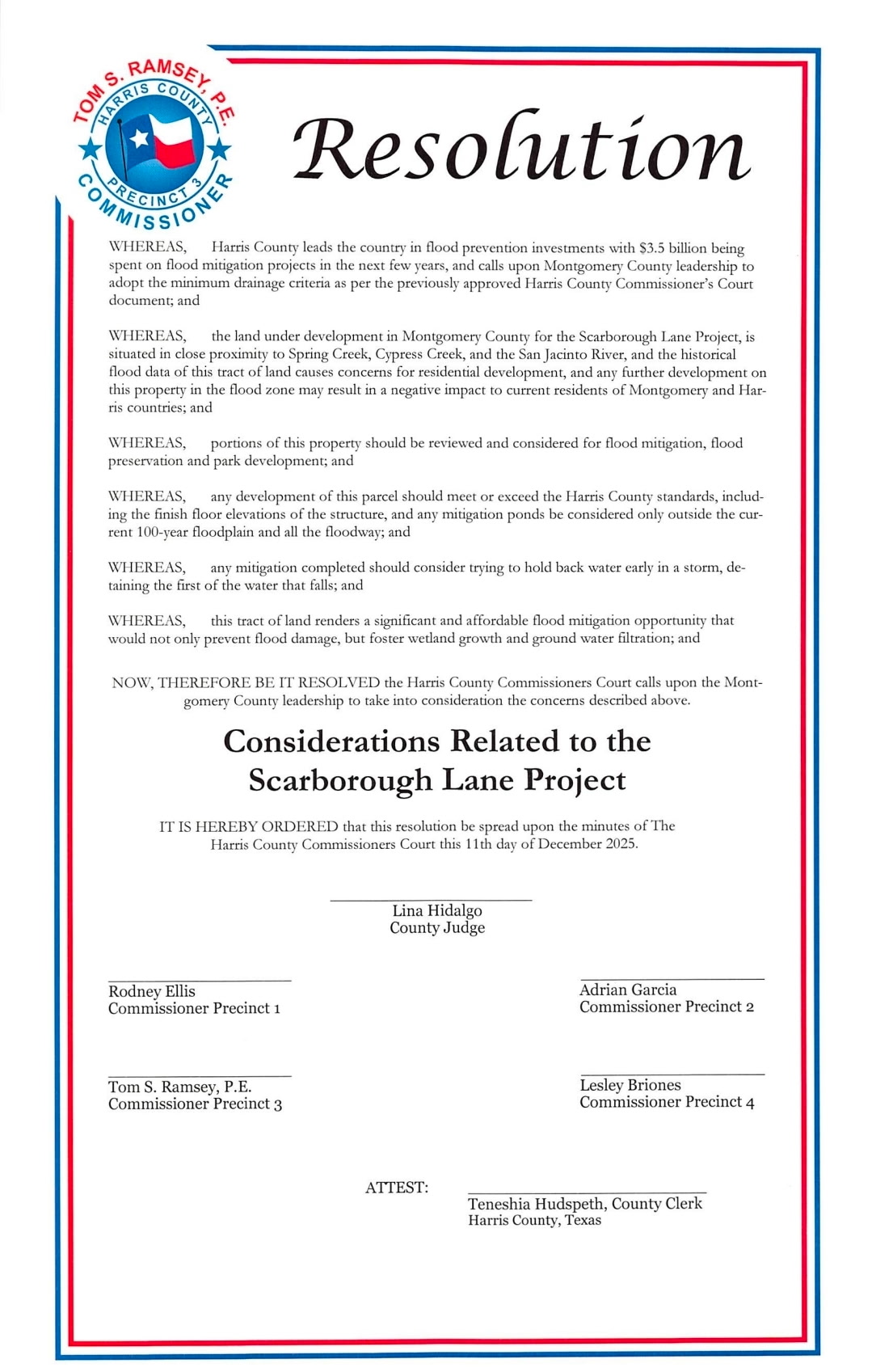
Montgomery County Updates Flood Regulations
Eight years after Harvey, Montgomery County finally adopted new subdivision, floodplain, and drainage regulations.
The county adopted its new subdivision (development) regulations on March 4, then amended them on May 27 and October 14. MoCo also issued subdivision guidelines and recommendations on November 4.
Commissioners adopted a new Drainage Criteria Manual on August 26. And new Floodplain Management Regulations became effective on October 1, 2025.
While MoCo regs don’t perfectly reflect the Minimum Drainage Standards recommended by Harris County for other counties draining into it, they are a great improvement.
Competing Forces at Work
Flood safety is a constant struggle between competing forces that increase or reduce flood risk. There are so many, the public can hardly know whether it’s winning or losing.
Just because the government appropriates money, doesn’t mean it’s enough or will be spent promptly.
Even if it is, will it actually reduce risk in the face of offsetting factors such as legislative loopholes, grandfather clauses, willful blindness, the profit motive, shifting political winds, and insufficiently mitigated upstream development?
And maybe that’s THE Top Flood-Related Story of 2025. More on that tomorrow.
Posted by Bob Rehak on 12/28/2025
3043 Days since Hurricane Harvey


