Tag Archive for: National Hurricane Center

Strong Thunderstorms, Street Flooding, Tornados Possible Tomorrow

Update: 10/28/22 11am: Today’s reports indicate the highest severe storm risk is shifting SW of Houston and offshore. Experts now predict 1-2 inches of rain for the Houston area today. Areas offshore are already getting 2-4 inches per hour.

Tomorrow will likely bring strong thunderstorms. Rainfall rates could exceed the capacity of street drains leading to localized street flooding. And the severe weather may also spin up some tornados, according to Harris County’s meteorologist and the National Weather Service (NWS).

Heavy Rainfall

NWS predicts two to three inches of rain could fall on Friday, as warm, moist air pushing in from the Gulf collides with a cold front pushing in from the northwest. Jeff Lindner, Harris County meteorologist, predicts the worst period for us will be Friday afternoon.

Tornados Possible

The NWS Storm Prediction Center in Norman, Oklahoma, issued this warning for Friday . It shows a marginal risk of severe weather for the entire Houston area and a slightly higher risk for areas south and west of us.

Reasons for Concern

For the weather wonks reading this, Lindner cites an unusual convergence of storm systems at different levels of the atmosphere.

A trough will begin to move eastward toward Texas later today. Surface pressures will begin to fall this afternoon as low pressure develops ahead of the approaching mid-level low. Southeast winds will increase today, letting Gulf moisture quickly return to coastal Texas.

As the mid-level low approaches us, it will meet the northward-moving, moisture-laden warm front moving in from the Gulf.

Severe threats will be highest along the boundary. Tropical moisture will march quickly northward tonight on a 30-knot low level jet. Precipitable waters – the amount of moisture in a column of air – will equal 1.8 inches by Friday morning over much of the region.

As large-scale lift increases over the developing warm sector, showers and thunderstorms will develop from southwest to northeast across the region.

The cold front associated with the mid-level low will sweep west to east across southeast Texas on Friday afternoon, touching off more thunderstorms. The front will slow Friday night, so showers will linger over the area.

Severe Threat: 

The surface low approaching from the northwest will meet the warm front coming from the opposite direction along a NW to SE axis on Friday. This warm front will extend from near San Antonio to near Freeport during the day and produce strong to severe thunderstorms. Low-level winds near the warm front will circle back toward the ESE and enhance low-level storm rotation.

Such collisions are notorious for tornado production, according to Lindner. Discrete cells may develop ahead of the line of storms approaching from the west. The location of the greatest severe risk will depend on where the warm front sets up Friday morning. Areas along and south of the front will have the highest risk.

If the warm front moves just a few miles farther north, it will increase risk to the Houston metro area. Kingwood was struck by tornados in a similar setup earlier this year.

Damaging winds will be the main threat. The worst of the storms should be over by 3-5 pm Friday, but lighter rains may linger well into the evening hours.  

Heavy Rainfall: 

Moisture will deepen Thursday into Friday. By Friday morning, a saturated air mass will be in place over the region. “Strong divergent lift coupled with low-level inflow will increase the potential for heavy rainfall along with cell training from southwest to northeast.”

Lindner describes himself as “aways wary of such setups.” They can help anchor and train convection.

The overall pattern favors supercell formation with both a tornado and heavy rainfall risk.

Jeff Lindner, Harris County Meteorologist

These storms could become significant rainfall producers – if they become sustained along the warm frontal boundary. The good news is that the ground is dry and can handle several inches of rainfall. “However, rainfall rates may exceed localized drainage capacities and result in some street flooding regardless of the dry ground conditions,” says Lindner.

Weekend: 

Cloudiness should linger much of Saturday keeping temperatures in the 50’s under northerly winds. South of the cloud line temperatures will warm into the 70’s. Where that line will be Saturday is hard to determine. Clouds should erode Saturday night with mostly clear skies. Sunday will be mild.  

Tropics:

The hurricane season has another month to go. It isn’t over yet! The National Hurricane Center now gives an area of low pressure moving WNW across the Caribbean a 50% chance of turning into a tropical depression in the next five days. No one is yet predicting what will happen if it does.

Posted by Bob Rehak on 10/27/22 based on information from Jeff Lindner, NWS, and NHC

1885 Days since Hurricane Harvey

NHC Gives 40% Chance of Formation to 91L Within 5 Days

Another tropical wave is moving into the Caribbean along the same track as Ian. As of Monday morning at 8 a.m., the National Hurricane Center gives it a 40% chance of developing within 5 days. Currently, the tropical wave is several hundred miles east of the Windward Islands and moving westward at 15-20mph. The NHC has designated this area of investigation as 91L.

Atlantic tropical waves and directions. Invest 91L is orange.

While Invest 91L looks fairly impressive on satellite images (see below), Jeff Lindner, Harris County meteorologist says, “There does not appear to be any closed low-level circulation yet. This wave should reach the eastern Caribbean Sea around mid-week and the western Caribbean by this weekend.”

91L is the storm north of the Guyanas and Suriname on the north coast of South America.

Says Lindner, “Conditions generally become favorable for development along the track of 91L, but when compared to Ian, model solutions are much more varied with development potential and also much more scattered. Some models take the storm into Central America, others predict it will track toward Puerto Rico and the Dominican Republic.

From Tropical Tidbits.

For now, watch and wait.

Orlene Moves Inland Over Mexico

In the meantime, the eastern Pacific is fairly active. NHC is tracking three storms. Two are moving northwest parallel to the Mexican coast as a third – Hurricane Orlene moves inland near Mazatlán.

Mid- and high-level moisture from Orlene will stream across our area later in the week. However, our air is so dry right now that precipitation aloft will likely not reach the ground.

Glancing Blow from Frontal Boundary Later in Week

Lindner also predicts, “Toward the end of this week, moisture may return to Texas from the Gulf of Mexico ahead of a front that will drop into the eastern U.S. The front should only strike a glancing blow to Texas. Most of it will head more southeast toward the Tennessee Valley. So rainfall potential for Houston will remain low. Our dry pattern will likely continue.”

The National Weather Service Storm Prediction Center sees little to no severe threat.

Posted by Bob Rehak on 10/3/2022 at 11:30 am

1861 Days since Hurricane Harvey

Another Tropical Wave Headed Toward Gulf

By this weekend, the second tropical wave in two weeks will make its way into the Gulf of Mexico. The National Hurricane Center (NHC) is monitoring a disturbance in the southwestern Caribbean. They predict it will track northwest across Central America and the Yucatan. Then it should emerge into the Gulf of Mexico later this week.

It’s too early to tell the exact track, timing or degree of development. That depends on many factors such as steering currents and frontal boundaries. But as of 7am Houston time on 8/16/22, NHC gives the disturbance a 20% chance of developing into a named storm within 5 days.

NHC says an area of low pressure could form on Friday. Gradual development of this system is possible while it moves northwestward over the southwestern Gulf of Mexico through the weekend.

15:20 Zulu time is 10:20 Houston time. Note the cloud formation in lower left over Nicaragua and Honduras.

Harris County Meteorologist Jeff Lindner says conditions will become increasing favorable for tropical cyclone development in the Bay of Campeche (the area with the yellow circle). He points to a frontal boundary dropping south toward the Texas coast late this week and says areas south of that boundary will become increasingly favorable for a low pressure system to develop along the axis of the tropical wave.

Weather Service Storm Prediction Center 3-Day Outlook shows front moving across southern plains on Friday.

However, there’s no reason to panic now. Just watch the National Hurricane Center website closely over the next several days for any changes.

Almost exactly 5 years ago, a storm followed a similar track across the Yucatan. It eventually became known as Hurricane Harvey.

Posted by Bob Rehak on 8/16/2022

1813 Days since Hurricane Harvey

NHC Predicts Above-Normal 2022 Atlantic Hurricane Season

On May 24, the National Hurricane Center (NHC) issued its forecast for the 2022 Atlantic hurricane season. NHC expects an above-average hurricane season for the seventh year in a row. They say an ongoing La Niña and above-average sea surface temperatures set the stage for a busy season. NHC’s predictions reinforce the forecast issued last month by Colorado State University.

From the National Hurricane Center

In case you missed that post, CSU predicted:

  • Named Storms: 19
  • Hurricanes: 9
  • Major Hurricanes: 4

Each of those numbers falls within the ranges shown above by NHC.

Seventh Consecutive Above-Average Season

Heat Map showing variation from normal for May 24, 2022. Source: NOAA. Note higher than normal temps in Gulf, Atlantic and most of Caribbean.

If NOAA predictions prove true, 2022 would make the seventh consecutive above-average hurricane season.

NOAA’s outlook for the 2022 Atlantic hurricane season, which extends from June 1 to November 30, predicts a:

  • 65% chance of an above-normal season
  • 25% chance of a near-normal season
  • 10% chance of a below-normal season.

For the 2022 hurricane season, NOAA is forecasting a likely range of 14 to 21 named storms (winds of 39 mph or higher), of which 6 to 10 could become hurricanes (winds of 74 mph or higher), including 3 to 6 major hurricanes (category 3, 4 or 5; with winds of 111 mph or higher). NOAA provides these ranges with a 70% confidence.

NOAA’s Climate Prediction Center will update the 2022 Atlantic seasonal outlook in early August, just prior to the historical peak of the season. 

The 2022 hurricane outlook is not a “landfall forecast.”

NOAA Enhances Products and Services

NOAA Administrator Rick Spinrad, Ph.D. emphasized that NOAA’s forecasting accuracy continues to improve. The agency has enhanced the following products and services this hurricane season:

Start Preparing Now

FEMA Administrator Deanne Criswell said, “It’s important for everyone to understand their risk and take proactive steps to get ready now.” Some tips:

  • Visit Ready.gov for preparedness tips on what to do before, during and after a flood.
  • Have several ways to receive alerts.
  • Download the FEMA app and receive real-time alerts from the National Weather Service for up to five locations nationwide. 
  • Sign up for community alerts in your area and be aware of the Emergency Alert System (EAS) and Wireless Emergency Alert (WEA), which require no sign up.

Posted by Bob Rehak on 5/25/22 based on information from the National Hurricane Center and Ready.Gov

1730 Days since Hurricane Harvey

Tropical Cyclone Formation Likely over Gulf

According to the National Hurricane Center, a large area of disorganized showers and thunderstorms centered around the Yucatan has a 70% chance of turning into a tropical cyclone in the next two days. NHC gives it an 80% chance of formation within five days.

Environment Becoming Conducive for Development

Although upper-level winds are not currently conducive for tropical cyclone development. However, they should become more favorable during the next day or so. A tropical depression is likely to form on Sunday or Monday while the disturbance moves northwestward and then northward near the coast of northeastern Mexico. Further development will be possible through the middle of next week if it remains over water. However, because the storm has no organized center at this time, where it will make landfall is hard to predict.

As of 7am CDT Saturday, September 11, 2021

“Global forecast models agree that a surface low will form, but where exactly remains in question,” says Jeff Lindner, Harris County Meteorologist.

The majority of the models predict the storm will focus on the western Gulf coastline. However, some models bring the storm closer to the Houston area.

Regardless, counter-clockwise rotation around any tropical cyclone should put Houston on the dirty side.

Heavy Rains Could Produce Flash and Urban Flooding

People along the western and northwestern Gulf coast should monitor the progress of this system. This disturbance should produce heavy rain across portions of Central America and the Yucatan Peninsula through today which may lead to flash flooding and mudslides.

According to Lindner, “By late this weekend, heavy rain will likely reach portions of the western Gulf coast. Expect rain over most of coastal Texas and Louisiana through the middle of next week. Localized significant rainfall amounts will be possible, potentially resulting in areas of flash and urban flooding.”

“Significant rainfall will be possible from Monday through Wednesday with excessive short-term rainfall rates of 2-4 inches per hour under any banding, training, or clustering of stronger cells.”

Jeff Lindner, Harris County Meteorologist

Expect very wet days early next week, especially near the coast. How far inland the heavy rains extend will depend on the degree of tropical cyclone development and the track of the storm. At this time, with high uncertainty, forecasters expect the heaviest rains near the coast with lower amounts inland.

Widespread rainfall amounts of 2-4 inches will be common over much of the area with much higher totals of 5-10 inches near the coast. Isolated totals in certain areas could exceed 10 inches.

While grounds are generally dry over the area, the magnitude of the rainfall in a short period of time could result in significant run-off generation especially over urban areas. Flooding concerns will increase as grounds become saturated early next week.

Winds/Seas/Tides

The high degree of uncertainty on where where any tropical cyclone will strike also affects winds, seas, and tides. But at the present, Lindner predicts easterly and southeasterly winds today into Sunday. He sees them increasing into the 20-30 mph range with seas building 6-10ft offshore by late Sunday into Monday.

Larger swells moving onto the coast will likely lead to some wave run-up and minor coastal flooding during high tides from late Sunday into early next week. 

Posted by Bob Rehak on 9/11/2021 based on information from NHC and HCFCD

1474 Days since Hurricane Harvey

Ida Now Hurricane, Predicted to Intensify to Category 4, Take Aim at New Orleans

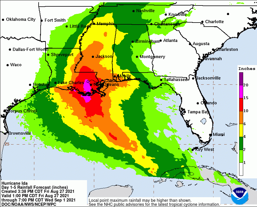
As of 3 p.m. CDT, the National Hurricane Center indicated Tropical Storm Ida had intensified into a hurricane about to cross over the western tip of Cuba. They warn that it could turn into a category 4 hurricane. It is currently predicted to cross over Louisiana, dump up to 20 inches of rain, and produce 15 feet of storm surge on Sunday.

Warnings Now In Effect

The NHC has also posted several warnings. They include:

  • Storm Surge Warning from Rockefeller Wildlife Refuge in Louisiana to the Mississippi/Alabama border.
  • Hurricane Warning for the coast of Louisiana including Lake Pontchartrain and Metropolitan New Orleans.
  • Tropical Storm Warning from the mouth of the Pearl River to the Mississippi/Alabama border.
  • Tropical Storm Warning for the coast of Louisiana from west of Intracoastal City to Cameron.
Hurricane Ida over the western tip of Cuba as of 3PM Houston time on 8/27/2021

Rapid Intensification

According to the National Hurricane Center, radar indicated a closed eye 24 nautical miles wide. Recon aircraft measured winds at 70 knots – hurricane intensity – at 3 PM Houston time.

Once Ida moves past western Cuba and into the southeastern Gulf of Mexico, it will be moving through very warm waters, low wind shear, and a moist low- to mid-level atmosphere. These conditions should result in rapid strengthening during the next 24 to 36 hours.

In fact, with the higher initial wind speed, the intensity guidance has significantly increased.

Models now predict Ida will reach category 4 intensity. The NHC forecast explicitly calls for rapid intensification during the next 24 to 36 hours.

National Hurricane Center

Some fluctuations in intensity are possible as Ida nears the northern Gulf coast due to possible eyewall replacement cycles. Models also call for Ida’s wind field to expand while it moves over the Gulf of Mexico. As a result, there is higher-than-normal confidence that a large and powerful hurricane will impact portions of the northern Gulf coast by late this weekend and early next week.

Ida has wobbled a little right of the previous track, but the longer term motion continues to be northwestward at about 14 mph.

Tracking Quickly Toward Louisiana Then Slowing

Steering currents push Ida northwestward across the Gulf this weekend. But Ida after landfall they will also slow northward motion and cause the system to turn northeastward.

Key Messages

However, remember not to focus on the exact details of the track. Storm surge, wind, and rainfall impacts will extend far from the center, says the NHC.

1. Life-threatening storm surge and hurricane conditions will continue through tonight in portions of western Cuba. Life-threatening heavy rains, flash flooding and mudslides are expected across Jamaica, the Cayman Islands, and western Cuba, including the Isle of Youth.

2. There is a danger of life-threatening storm surge inundation Sunday along the coasts of Louisiana and Mississippi within the Storm Surge Warning area. Extremely life-threatening inundation of 10 to 15 feet above ground level is possible within the area from Morgan City, Louisiana, to the Mouth of the Mississippi River. Interests throughout the warning area should follow any advice given by local officials.

3. Ida is expected to be an extremely dangerous major hurricane when it reaches the coast of Louisiana. Hurricane-force winds are expected Sunday along the Louisiana coast, including metropolitan New Orleans, with potentially catastrophic wind damage possible where the core of Ida moves onshore. Actions to protect life and property should be rushed to completion in the warning area.

4. Ida is likely to produce heavy rainfall later Sunday into Monday across the central Gulf Coast from southeast Louisiana to coastal Mississippi and Alabama, resulting in considerable flash, urban, small stream, and riverine flooding impacts. As Ida moves inland, flooding impacts are possible across portions of the Lower Mississippi and Tennessee Valleys.

Story of the Storm in Picture

Confidence in track is increasing. Ida should reach the Louisiana and Mississippi coasts by Sunday afternoon.
…but tropical-storm-force winds should arrive by Sunday morning.
Most of the Houston area only has about a 10-30% chance of experience tropical-storm-force winds.
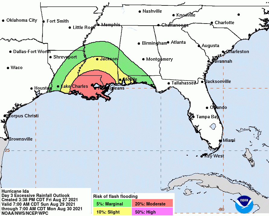
And we have practically no chance of excessive rainfall that could create flash flooding.
Portions of Louisiana, however, will like see 15-20 inches of rain.
But the biggest threat by far to our neighbors will come from storm surge. Portions of the delta could see as much as 15 feet above ground level.

Prays for our neighbors. And thank God that we’re on the dry side of this storm. It should hit on August 29th, the fourth anniversary of when Hurricane Harvey triggered massive evacuations in the Lake Houston Area.

Posted by Bob Rehak on 8/27/2021

1459 Days since Hurricane Harvey

Atlantic Basin Heating Up with Potential Tropical Activity

As we approach the 4th anniversary of Hurricane Harvey, the Atlantic basin is currently heating up with tropical activity. As remnants of one hurricane washing across New England, two more areas of concern move toward the Northeast. A third is heading toward the northwest Caribbean. It’s still too early to tell exactly where these storms will make landfall. But the presence of so many tropical disturbances signals the need to stay alert to daily weather forecasts.

Each of these storms has a 40-60% chance of tropical formation.

Five Day Outlook for Tropical Activity

8 PM outlook on 8/23/2021 indicates the storms heading toward the NW Caribbean have a 50% chance of tropical formation in the next five days. That’s up from 30% this morning.

Retreat of High-Pressure System Over Texas

National Hurricane Center (NHC) forecasts a tropical wave over the eastern Caribbean Sea will form a broad area of low pressure over the southwestern Caribbean Sea by late week. Thereafter, environmental conditions favor gradual development while the system moves west-northwestward to northwestward over the northwestern Caribbean Sea.

In addition to that, another major low pressure area over Mexico and the Bay of Campeche could move into the Gulf by this weekend though no tropical activity is forecast at this time.

Note massive low pressure system moving into Gulf.

Jeff Lindner, Harris County meteorologist, warns that as the high pressure ridge currently sitting over Houston begins to retreat north by Wednesday, “A series of tropical waves and disturbances will move from east to west across the US Gulf coast and into coastal TX from mid week onward. With a significant influx of Gulf moisture, showers and thunderstorms will return as early as Wednesday across much of the area and last likely into next week. Locally heavy rainfall will become an increasing threat by late week and this weekend with tropical moisture firmly in place over the region.”

Historical Norms for Late August

NOAA’s Climate Center shows that the projected path of the current areas of concern should follow historical norms for this time of the year.

This diagram shows the most likely areas for formation for hurricanes in August and their prevailing tracks. Source: NOAA’s Climate Center.

This is one of the reasons why.

Current sea surface temperatures in the Gulf are running 1.5 to 2+ degrees degrees above normal for the next seven days, with the warmer areas nearer the Texas Coast.

Historical Intervals Between Major Hurricanes

NOAA’s Climate Center shows the average interval for major hurricanes striking the Houston area is about every 25 years.

NOAA’s Climate Center also tracks the average return period for MAJOR hurricanes at various points along the coastline. They show that the Houston area can expect on average one major hurricane about every 25 years.

Of course, a hurricane doesn’t have to be major to cause major damage. Allison and Imelda were just tropical storms. And averages are just that – averages. Ike in 2008 and Harvey in 2017 each attained major hurricane status and hit Houston within 9 years of each other.

Posted by Bob Rehak on 8/23/2021 based on information from NHC and HCFCD

1455 Days since Hurricane Harvey

Elsa Upgraded to Hurricane

A USAF mission into Elsa along with radar data and surface observations from Barbados indicate that Elsa is now a hurricane. However, uncertainty remains about the storm’s track and intensification.

Elsa in the center of the image is skirting the northern coast of South America and about to cross over the windward islands. Note the small core near the center.

Just yesterday, the NHC showed Elsa remaining a tropical storm all the way to Florida. Now, the National Hurricane Center shows hurricane conditions are quickly spreading into the Windward Islands. Various watches and warnings are in effect for portions of the Caribbean Islands (See graphic below).

86 MPH Winds Reported

According to Jeff Lindner, Harris County’s meteorologist, Elsa has taken advantage of favorable conditions in the last 24 hours. Both the Air Force and land observers reported sustained winds of 86mph this morning. That makes Elsa a hurricane. Radar indicates good banding features and a small, central core.

Elsa continues to race WNW near 30mph which is extremely fast for a hurricane.

However, the system has thus far kept its low- and upper-level centers aligned.

Track

A strong sub-tropical ridge of high pressure to the north of the hurricane, will influence the track for the next 48 hours. Then Elsa will approach a weakness in the ridge and the forecasts become more uncertain.

One model shows the storm nearly dissipating over the Dominican Republic by Sunday. However, others show Elsa turning more north. Increasingly, this appears to be the more likely outcome. However, the spread is very large from east of the Bahamas to near the northern Yucatan at days 4-5 so confidence remains lower than average on the track.

Two models show Elsa making a beeline toward the central Gulf, but most take it east.

Intensity

Conditions seem favorable for increasing development. But the fast forward motion of Elsa could become a negative factor. Models show a large spread in intensity guidance, but most keep Elsa near the intensity it is now. As it approaches the Gulf, it should be a strong tropical storm or weak hurricane, but some forecasters see it growing much stronger.

NHC continues to lean toward the lower end of the guidance spectrum, but continues to indicate that Elsa could become stronger than forecasted – especially over the NW Caribbean Sea early next week.

Keep one eye on the Gulf. For the latest updates, check the National Hurricane Center.

Posted by Bob Rehak on 7/2/2021 at 8:30 am based on information from the NHC and HCFCD

1403 Days since Hurricane Harvey

Two Systems Approaching Caribbean

A strong tropical wave located midday between Africa and the eastern Caribbean Sea continues to show increasing signs of organization. The red area below has an 80% chance of tropical formation in the next five days, according to the National Hurricane Center (NHC) as of 8 a.m. this morning.

Red storm has 80% chance of tropical formation as of 8 am, June 30, 2021 according to National Hurricane Center.

Storm Farthest East Represents Biggest Threat

Convection has increased near a developing low-level, low-pressure system designated 97L for the moment. 97L has a large moisture envelop and conditions generally favor development as it moves westward.

According to Jeff Lindner, Harris County meteorologist and the National Hurricane Center, a tropical depression will likely form in the next few days. It may also turn into a tropical storm as it approaches the Windward Islands. They expect continued W to WNW motion bringing the system into and through the eastern Caribbean Sea by the weekend.

Models Diverge on Direction After Storm Enters Caribbean

It’s too early to tell where it goes after that. Some models suggest the system will turn WNW and NW while others maintain a more westward track. “There is reasonable support for both,” says Lindner.

Lindner emphasizes that it is early for tropical cyclones to form in this region of the Atlantic. While 97L may become a tropical storm as it approaches the Windward Islands, once it gets past them, it may encounter slightly less favorable conditions over the eastern Caribbean Sea.

While there is no significant threat to SE TX at this time, you should monitor 97L daily.

Nearest Storm Poses Less Threat

The yellow area is a second, separate area being monitored by the NHC. It is moving quickly WNW at 20 to 25 mph and will enter the Caribbean later today. However, it is producing only disorganized showers and thunderstorms so far and diverging trade winds may tear it apart. The NHC only gives it a 10% chance of tropical formation. So while it will bring heavy rainfall to the Lesser Antilles, it poses little danger to Houston.

For the latest information, the NHC updates storm tracks every 12 hours during the hurricane season and even more frequently if storms approach the U.S. mainland.

Posted by Bob Rehak based on information from HCFCD and the National Hurricane Center

1401 Days after Hurricane Harvey

Another Above-Average Hurricane Season Predicted

This is the time of year when meteorologists start predicting how many hurricanes we will experience in the Atlantic Basin. Frank Billingsley at Click2Houston.com issued his prediction for an above-average hurricane season Friday. He also predicts that other meteorologists will predict the same. Here’s why.

Official Averages Out of Date

The official window used to calculate the average number of storms has been 1981 to 2010. But when Brian McNoldy of the University of Miami looked at the more recent 30 years from 1991 to 2020, he found an increase in the number of storms. Also, AccuWeather has already come out with its prediction, showing a substantial increase.

Year(s)StormsHurricanesMajor Hurricanes
1981-2010 (Old Average)1263
1991-2020 (New Average)1473
2020 Actual30136
2021 Predicted by AccuWeather16 to 207 to 103 to 5
Sources: Brian McNoldy, AccuWeather, NHC

Other Contributing Factors

Sea-Surface Temperatures

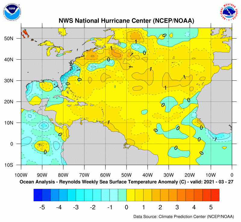
Sea-surface temperatures are slightly above normal for this time of year. Despite the polar outbreak in February which cooled the Gulf somewhat, the Caribbean and Atlantic remain higher than average. See anomaly map below from NOAA’s Climate Prediction Center.

Seven day average as of 4/3/2021
La Niña

Billingsley’s prediction also takes into account La Niña, which is part of ENSO (El Niño Southern Oscillation).

NOAA describes El Niño and La Niña as the warm and cool phases of a recurring climate pattern across the tropical Pacific. The pattern can shift back and forth irregularly every two to seven years, and each phase triggers predictable disruptions of temperature, precipitation and winds.

The El Niño phase usually means fewer hurricanes in the Atlantic.

Typical influence of El Niño on Pacific and Atlantic seasonal hurricane activity. Map by NOAA Climate.gov, based on originals by Gerry Bell.

The La Niña phase usually means more hurricanes in The Atlantic.

Typical influence of La Niña on Pacific and Atlantic seasonal hurricane activity. Map by NOAA Climate.gov, based on originals by Gerry Bell.

Why? In short, the warm, wet air of El Niño in the tropical Pacific produces stronger vertical wind sheer which discourages hurricane formation in the Atlantic. The cool, dry air of La Niña produces less wind sheer which lets hurricanes form more easily.

National Hurricane Center

The real question is: How long will La Niña last? La Niña was strong last year. That meant one of the busiest hurricane seasons ever. (See table above.) But will it fade by the start of this hurricane season or the end? The Texas Water Development Board predicted it would begin to fade after this month. But some models show it lasting through the end of the year.

Bermuda High

AccuWeather predicts three to five hurricanes will make a direct hit on the United States this year. That’s partially due to another factor – the position of the Bermuda High. A weak Bermuda High means storms forming in the Atlantic would most likely aim at the Eastern Seaboard as opposed to coming into the Gulf.

Bottom line, “Be prepared. Anyone who has been through a hurricane can tell you it only takes one.”

Frank Billingsley, Click2Houston.com

Valuable Resources During Hurricane Season

For the full AccuWeather forecast, click here.

Colorado State University’s hurricane forecast comes out next week. It’s one of the most respected in the world.

During the season, the National Hurricane Center provides the most frequent updates of storm activities. They will start issuing tropical updates on May 15. And their reports will have more features than ever this year. See the list of new features including storm surge inundation values, weather forecasts for “blue-water” mariners, wave heights, cumulative maximum winds over 5-days, and more.

Posted by Bob Rehak on 4/3/2021 based on information from Click2Houston, AccuWeather, and NOAA

1313 days since Hurricane Harvey