
Ida Now Hurricane, Predicted to Intensify to Category 4, Take Aim at New Orleans
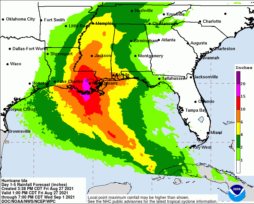
As of 3 p.m. CDT, the National Hurricane Center indicated Tropical Storm Ida had intensified into a hurricane about to cross over the western tip of Cuba. They warn that it could turn into a category 4 hurricane. It is currently predicted to cross over Louisiana, dump up to 20 inches of rain, and produce 15 feet of storm surge on Sunday.
Warnings Now In Effect
The NHC has also posted several warnings. They include:
- Storm Surge Warning from Rockefeller Wildlife Refuge in Louisiana to the Mississippi/Alabama border.
- Hurricane Warning for the coast of Louisiana including Lake Pontchartrain and Metropolitan New Orleans.
- Tropical Storm Warning from the mouth of the Pearl River to the Mississippi/Alabama border.
- Tropical Storm Warning for the coast of Louisiana from west of Intracoastal City to Cameron.

Rapid Intensification
According to the National Hurricane Center, radar indicated a closed eye 24 nautical miles wide. Recon aircraft measured winds at 70 knots – hurricane intensity – at 3 PM Houston time.
Once Ida moves past western Cuba and into the southeastern Gulf of Mexico, it will be moving through very warm waters, low wind shear, and a moist low- to mid-level atmosphere. These conditions should result in rapid strengthening during the next 24 to 36 hours.
In fact, with the higher initial wind speed, the intensity guidance has significantly increased.
Models now predict Ida will reach category 4 intensity. The NHC forecast explicitly calls for rapid intensification during the next 24 to 36 hours.
National Hurricane Center
Some fluctuations in intensity are possible as Ida nears the northern Gulf coast due to possible eyewall replacement cycles. Models also call for Ida’s wind field to expand while it moves over the Gulf of Mexico. As a result, there is higher-than-normal confidence that a large and powerful hurricane will impact portions of the northern Gulf coast by late this weekend and early next week.
Ida has wobbled a little right of the previous track, but the longer term motion continues to be northwestward at about 14 mph.
Tracking Quickly Toward Louisiana Then Slowing
Steering currents push Ida northwestward across the Gulf this weekend. But Ida after landfall they will also slow northward motion and cause the system to turn northeastward.
Key Messages
However, remember not to focus on the exact details of the track. Storm surge, wind, and rainfall impacts will extend far from the center, says the NHC.
1. Life-threatening storm surge and hurricane conditions will continue through tonight in portions of western Cuba. Life-threatening heavy rains, flash flooding and mudslides are expected across Jamaica, the Cayman Islands, and western Cuba, including the Isle of Youth.
2. There is a danger of life-threatening storm surge inundation Sunday along the coasts of Louisiana and Mississippi within the Storm Surge Warning area. Extremely life-threatening inundation of 10 to 15 feet above ground level is possible within the area from Morgan City, Louisiana, to the Mouth of the Mississippi River. Interests throughout the warning area should follow any advice given by local officials.
3. Ida is expected to be an extremely dangerous major hurricane when it reaches the coast of Louisiana. Hurricane-force winds are expected Sunday along the Louisiana coast, including metropolitan New Orleans, with potentially catastrophic wind damage possible where the core of Ida moves onshore. Actions to protect life and property should be rushed to completion in the warning area.
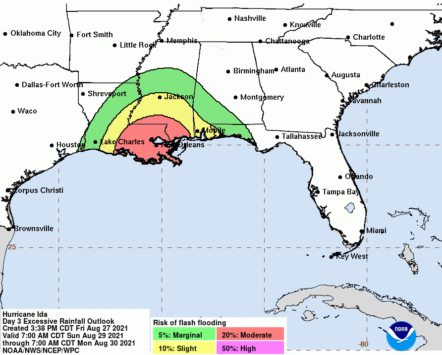
4. Ida is likely to produce heavy rainfall later Sunday into Monday across the central Gulf Coast from southeast Louisiana to coastal Mississippi and Alabama, resulting in considerable flash, urban, small stream, and riverine flooding impacts. As Ida moves inland, flooding impacts are possible across portions of the Lower Mississippi and Tennessee Valleys.
Story of the Storm in Picture


Prays for our neighbors. And thank God that we’re on the dry side of this storm. It should hit on August 29th, the fourth anniversary of when Hurricane Harvey triggered massive evacuations in the Lake Houston Area.
Posted by Bob Rehak on 8/27/2021
1459 Days since Hurricane Harvey


