Tag Archive for: National Hurricane Center

Milton To Make Landfall Near Tampa in Hours

10/9/24 at 5 PM – Tropical storm force winds from Hurricane Milton can already be felt in the Tampa Bay Area. The storm is moving toward Tampa at 17 MPH. On the forecast track, the center of Milton will make landfall near or just south of the Tampa Bay region this evening.

Milton’s location at 4:46 PM CDT. Eye has become obscured by clouds. Milton covers the entire Florida Peninsula.

According to the National Hurricane Center, it will then move across the central part of the Florida peninsula overnight, and emerge off the east coast of Florida on Thursday.

120 MPH Cat 3 Storm at Present

Maximum sustained winds are near 120 MPH with higher gusts. Milton is a category 3 hurricane on the Saffir-Simpson Hurricane Wind Scale. Milton could still be a major hurricane when it reaches the coast of west-central Florida this evening. And it will remain a hurricane while it moves across central Florida through Thursday. Milton should weaken over the western Atlantic and become extratropical by Thursday night.

Hurricane-force winds extend outward up to 35 miles from the center and tropical-storm-force winds extend outward up to 255 miles. Central pressure is 948 mb.

“Life-threatening hurricane-force winds, especially in gusts, are expected to spread inland across the peninsula and to portions of the Florida east coast tonight and early Thursday,” warns NHC.

Add to that the risk of strong tornadoes. Warnings are already up.

9-13 Feet of Surge Predicted Just South of Tampa

Even though meteorologists have tightened their estimates, storm surge is still a significant threat. The deepest water will occur along the immediate coast near and to the south of the landfall location. There, surge will be
accompanied by large and dangerous waves. Surge-related flooding depends on the relative timing of the surge and the tidal cycle, and can vary greatly over short distances.

NHC predicts the eye will pass just south of Tampa and has scaled back surge predictions there too 6-9 feet, considerably lower than the 10-15 feet predicted yesterday.

However, slightly south, surge predictions still range from 9-13 feet down to Boca Grande, and 8-12 feet down to Bonita Beach.

NHC says, “There will likely be a noticeable gradient of surge heights to the north of the landfall location, however, the risk of devastating storm surge still exists across much of the west-central and southwest coast of Florida given the size of the storm.”

“Water levels will rise rapidly as the eye approaches, and strong onshore winds on the backside of the hurricane will also cause a rapid rise in water as the center makes landfall.”

Up to 18 Inches of Rainfall

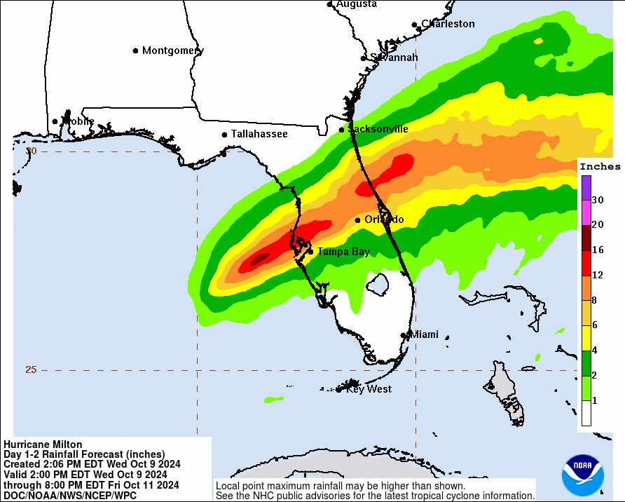
Rainfall amounts of 6 to 12 inches will be common. Localized totals up to 18 inches are expected across the central to northern portions of the Florida Peninsula through Thursday.

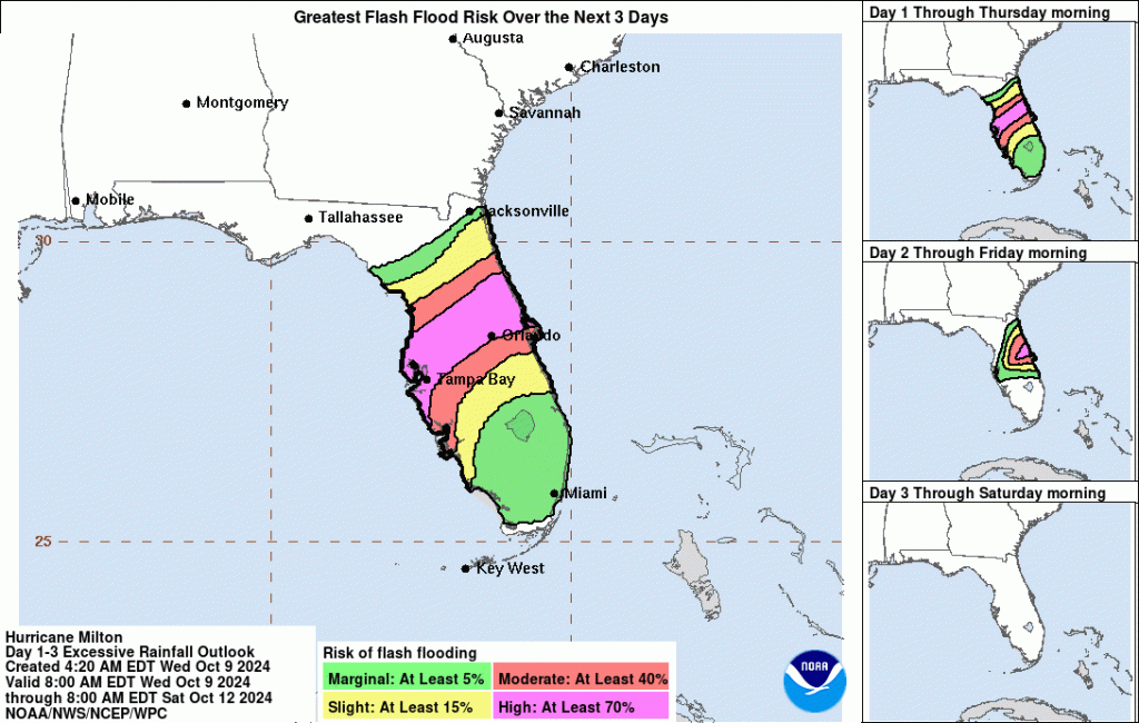
Life-Threatening Flood Potential

This heavy rainfall brings the risk of catastrophic and life-threatening flash and urban flooding along with moderate to major river flooding, especially in areas where coastal and inland flooding combine to increase the
overall flood threat.

About the only thing left to do at this point is pray for a speedy recovery. But based on Houston’s experience with Hurricane Harvey, I can promise you that recoveries from storms of this magnitude are anything but speedy.

That’s the main reason why I continue to post “Days since Harvey” with all of my posts. I want people to understand how long recovery and mitigation take.

Posted by Bob Rehak on 10/09/24 based on information from the NHC and Harris County Meteorologist Jeff Lindner

2598 Days since Hurricane Harvey

Milton Could Be One of Most Destructive Hurricanes On Record

10/8/24 4 PM – As if the pictures of Helene’s aftermath weren’t enough, the National Hurricane Center (NHC) says that “Milton has the potential to be one of the most destructive hurricanes on record for west-central Florida.”

Milton weakened to a Category 4 overnight during an eye wall replacement cycle and is now regaining strength as it expands into a larger storm. At 4 PM, it had a 10-mile-wide eye and was turning northeast, moving at 9 MPH.

NHC also reported that Milton regained Cat 5 strength and had sustained winds of 165 MPH.

Milton
Milton was north of the Yucatan at 3PM CDT.

Typically, Cat 5 storms destroy a high percentage of framed homes, with total roof failure and wall collapse. NHC warns that “fallen trees and power poles will isolate residential areas. Power outages will likely last for weeks to possibly months. Most of the area will be uninhabitable for weeks or months.”

Ironically, much of the area that Milton will hit was already heavily damaged by Helene two weeks ago. Cleanup from Helene is not yet complete. The high winds could create a blizzard of debris and airborne projectiles.

Authorities are urging residents in evacuation zones to get out today as there may not be enough time if they wait until tomorrow.

Highly Populated Area in Crosshairs

The National Hurricane Center’s (NHC) forecast track currently puts the Tampa Bay Area in the crosshairs with landfall tomorrow.

However, NHC cautions that, this far in advance, their forecasts typically contain 60-70 miles of error.

The outer winds could reach the Florida coast tomorrow. And the hurricane should make landfall early Thursday, crossing the Florida Peninsula, emerging into the Atlantic Ocean on Friday.

NHC says that preparations to protect life and property, and to be ready for long-duration power outages, should be complete by tonight. By tomorrow, conditions will deteriorate and it may not be safe to work outside.


Wind Field, Storm Surge Will Affect Much of Florida

NHC also says that “Milton’s wind field is expected to expand as it approaches Florida. In fact, the official forecast shows the hurricane and tropical-storm-force winds roughly doubling in size by the time it makes landfall. Therefore, damaging winds, life-threatening storm surge, and heavy rainfall will extend well outside the forecast cone.”

At 1 PM, hurricane-force winds extended outward up to 30 miles from the center and tropical-storm-force winds extended outward up to 140 miles.

Storm surge in the Tampa area could reach 15 feet above dry ground. Surge warnings affect the entire western coast of Florida, the Florida Keys and Dry Tortugas. Note below that NHC has also posted surge warnings for most of Florida’s eastern coast up through Georgia and South Carolina.

Heavy Rains and Flooding

NHC predicts 5 to 12 inches of rainfall, with localized totals up to 18 inches, across central to northern Florida through Thursday.

This rainfall will bring the risk of life-threatening flash and urban flooding, along with
moderate to major river flooding, according to NHC.

For a complete depiction of forecast rainfall associated with Hurricane Milton, see the National Weather Service Storm Total Rainfall Graphic, available at hurricanes.gov/graphics_at4.shtml?rainqpf and the Flash Flood Risk
graphic at hurricanes.gov/graphics_at4.shtml?ero
.

Posted by Bob Rehak at 3:30 PM, 10/8/24

2597 Days since Hurricane Harvey and 13 since Helene

NHC Issues Advisory on Potential Tropical Cyclone 4

8/2/24 5PM – The National Hurricane Center (NHC) has issued an advisory about Potential Tropical Cyclone 4. It affects people on the west coast of Florida for now. Since yesterday, models have come into closer alignment. There is now a higher degree of certainty that the PTC4 will track up the west coast of Florida, then cut east around Tampa and emerge into the Atlantic.

Current Status and Forecast

Land interaction with Cuba has limited strengthening of the storm today. But by 2PM Saturday, it should emerge into the eastern Gulf and intensify into a tropical storm before making landfall.

Maximum sustained winds are currently at 30 MPH, but will accelerate Saturday and Sunday.

NHC forecasts a 40-50% probability that the Florida’s western coast will see tropical storm force winds (one minute average >= 39MPH). The earliest arrival time on the southern tip of Florida is 8 AM Saturday 8/3/24.

So far, the tropical wave has not yet reached tropical storm force anywhere in the Atlantic or Caribbean. However, tropical storm watches and warnings are up for the entire western coast of Florida.

NOAA’s latest satellite imagery shows the storm centered over Cuba at 21:40 Z on 8/2/24.

PTC4’s position over Cuba as of 4:40 CDT.

Up to a Foot of Rain and 4 Feet of Storm Surge

NHC expects tropical storm conditions to follow the storm up the eastern seaboard through next Wednesday. They also warn of life-threatening storm surge (2-4 feet) and coastal flooding from Georgia to North Carolina next week. Finally, they warn of isolated river flooding.

Expect rainfall totals of 4 to 8 inches, with maximum rainfall totals up to 12 inches, across portions of Florida and along the Southeast U.S. coast this weekend through Wednesday morning.

Next Storm Name Is Debby

This storm should become “Debby.” Chris had a short life and veered into northern Mexico as Beryl was moving toward Houston.

For the time being, people in the Houston area can breathe easier. But the Atlantic hurricane season is just starting to heat up. It will peak on September 10.

peak of hurricane season
From: https://www.nhc.noaa.gov/climo/

Where to Find the Latest Information

Those with friends, relatives or vacation plans in the southeast can track the progress of the storm in satellite images at:

https://www.nhc.noaa.gov/satellite.php.

For the latest NHC forecasts, visit: https://www.nhc.noaa.gov/graphics_at4.shtml?start#contents.

NHC issues updates every 4 hours when a storm threatens.

Posted by Bob Rehak on 8/2/24 at 5:30 PM

2530 Days since Hurricane Harvey

New Forecasts Show Latest Disturbance Now Moving Toward Gulf

8/1/24 – 7PM Update – Since posting this story earlier today, NHC has shifted its predictions even farther west and increased development chances to 40% in two cays and 70% in 7 days.

8/1/24, 9 AM – According to the National Hurricane Center (NHC), a well-defined tropical wave is now moving toward the Gulf. This represents a significant change from earlier predictions that took the storm east of Florida.

The system is currently producing a large area of disorganized showers and thunderstorms over the southwestern Atlantic and northeastern Caribbean Sea.

Location as of 8/1/24 at 9AM CDT

Development Chances

Development of this system should occur slowly during the next two days. Environmental conditions will soon become more conducive for development. And a tropical depression could form this weekend or early next week over the eastern Gulf of Mexico.

The system has a 20% chance of formation in the next 2 days and a 60% chance in the next 7.

National Hurricane Center

NHC and others have discussed this tropical wave for about a week now. In the last 2 days, shower and thunderstorm development has become better organized, but there is still no defined circulation at the surface at this time.

The wave axis should reach Cuba by early this weekend. According to Jeff Lindner, Harris County meteorologist, land interaction will likely prevent any sort of significant development in the near term – unless a center forms either south or north of the inlands.

Likely Track

Toward this weekend it is now likely that the wave will enter the eastern Gulf of Mexico. After that, the steering patterns become highly complex.

Forecasts have a high degree of uncertainty. Different models show numerous outcomes in the eastern Gulf during the next 5-7 days.

Weak Storm Likely at This Point

Intensity forecasts are also very uncertain at this point. Most models predict a weak system. But once a defined surface center forms, intensification looks likely.

Factors Supporting Development

Lindner points to three factors supporting eventual development.

Conditions supporting intensification over the eastern Gulf of Mexico include:

  • Very warm sea surface temperatures
  • Light wind shear
  • Potential for dual outflow channels aloft.

Role of Dual Outflow Channels in Formation

Meteorologists frequently talk about shear and sea surface temperatures in relation to hurricane formation. But they talk less often about the importance of outflow channels. How do outflow channels support hurricane formation?

Dual outflow channels are important in hurricane formation because they can enhance the efficiency and intensity of a storm.

According to ChatGPT, they provide:

  1. Enhanced Ventilation: This allows the hurricane to expel air more efficiently, promoting a stronger inflow at the surface.
  2. Symmetrical Structure: With outflow in multiple directions, the hurricane maintains a more symmetrical structure.
  3. Lower Pressure: Efficient outflow channels contribute to lowering the central pressure of the hurricane. Lower pressure at the core leads to higher wind speeds and a more powerful storm.
  4. Sustained Intensification: Dual outflow channels can support sustained intensification by continually removing air from the upper levels, allowing the storm to draw in warm, moist air from the ocean surface.
  5. Balanced Energy Distribution: The channels help distribute energy more evenly around the storm, preventing one side from becoming too dominant and potentially disrupting the hurricane’s structure.

Dual outflow channels thus help enhance the structural integrity, efficiency, and intensity of hurricanes.

Preparations

At this time, no one predicts that the storm will reach as far west as Houston. But last week, no one predicted that it would reach the Gulf either.

As always, your best bet is to be prepared for anything. Restock food, water and batteries used after Beryl. Recharge your backups. And monitor the NHC daily.

Posted by Bob Rehak on 8/1/24

2529 Days since Hurricane Harvey

Beryl Goes from Tropical Storm to Cat 4 in One Day

6/30/24, 4 PM – Beryl intensified from a tropical storm yesterday morning to a category 4 hurricane with 130 mph winds this afternoon.

Satellite image taken at 3:30 CDT

Elsewhere, Tropical Depression #3 has formed in the Bay of Campeche. NHC predicts it will become a tropical storm by tonight and make landfall near where Alberto did in Mexico less than two weeks ago.

4PM Update on Beryl

The National Hurricane Center (NHC) says that the hurricane continues to move swiftly westward at 18 kt, steered by a strong subtropical ridge to its north. Beryl has made only a minor shift to the north since this morning, following the trend in the latest models.

Potentially catastrophic hurricane-force winds, a life-threatening storm surge, and damaging waves are expected when the hurricane passes over portions of the Windward Islands. At highest risk: St. Vincent and the Grenadines, and Grenada beginning early Monday morning.

Latest cone of uncertainty for Beryl as of 3PM CDT, 6/30/24

As the hurricane tracks across the Caribbean Sea, there likely will be a gradual increase in wind shear, which should weaken it slightly. However, NHC predicts that Beryl will remain a significant hurricane during its entire trek across the Caribbean region.

So far, the storm’s path has been eerily reminiscent of Harvey’s.

From Wikipedia

Here are the latest track forecasts of various models for today’s storm.

Some models take the path toward Houston, but the consensus seems a bit west.

Sea Surface Temps in Gulf

If Beryl makes it to the Gulf, it will encounter favorable sea surface temps.

Sea Surface Temperature departures from normal. 2 degrees Celsius = 3.6 degrees Fahrenheit.

It is too early to predict atmospheric conditions in the Gulf next weekend.

Record-Breaking Beryl

As it spins across the Atlantic, Beryl has already set two records:

  • Farthest east a hurricane has ever formed in the Atlantic in June
  • Earliest Cat 4 Hurricane on record.

Before this storm, the record earliest Category 4 hurricane was Dennis on July 8, 2005.

Posted by Bob Rehak at 4PM CDT on 6/30/24

2497 Days since Hurricane Harvey

Beryl Expected to Become Category 4 Hurricane

6/30/24, 7 AM CDT – The National Hurricane Center (NHC) now predicts that Hurricane Beryl could rapidly intensify into a Category 4 hurricane before reaching the Windward Islands early Monday morning. At 7 AM CDT, NHC estimated Beryl’s maximum sustained winds at 115 mph. That would currently make it a Category 3 hurricane on the Saffir-Simpson Wind Scale, which estimates damage to structures at various wind speeds. (See below.)

High SSTs, Low Wind Shear

Sea surface temperatures in Beryl’s path reach 84.2 degrees Fahrenheit, more typical of August than June. And as Beryl moves westward, wind sheer is decreasing. Both factors favor rapid intensification.

Thus, the latest NHC intensity forecast continues to show rapid intensification over the next day, making Beryl an extremely dangerous Category 4 hurricane before it reaches the Windward islands.

Once Beryl enters the Caribbean, increasing shear will likely cause the hurricane’s intensity to level off, then start weakening around midweek, according to NHC. 

Eye Wall Development

Recent satellite imagery shows the development of an eye, with cooling cloud tops in the eyewall and a warming eye. 

From National Hurricane Center at 6:20 CDT on 6/30/24

Two Hurricane Hunter aircraft measured the maximum wind speed this morning.

Beryl Continues to Track Mostly Westward

The hurricane is moving slightly north of due west at about 20 mph.  There aren’t any significant track changes from the previous advisory. An extensive mid-level, high-pressure ridge north of Beryl will steer the system westward or west-northwestward for several days. 


Model guidance remains in tight agreement on the forecast track. NHC’s 4 AM Atlantic Standard Time update notes that track prediction is basically an update of the previous one.

The farther out you get, the more models diverge. The average of all models eventually shows the storm moving into the western Gulf.

Category 4 Risks

This is a very serious situation developing for the Windward Islands. Beryl will bring destructive winds, life-threatening storm surge, heavy rainfall and flooding for much of the Windward Islands tonight and Monday.

Saffir-Simpson Wind Scale Categories

For those new to the Gulf Coast, the Saffir-Simpson Hurricane Wind Scale is a 1 to 5 rating based only on a hurricane’s maximum sustained wind speed.

This scale does not take into account other potentially deadly hazards such as storm surge, rainfall flooding, and tornadoes.

The Saffir-Simpson Hurricane Wind Scale estimates potential property damage. While all hurricanes produce life-threatening winds, hurricanes rated Category 3 and higher are known as major hurricanes.

Major hurricanes can cause devastating to catastrophic wind damage and significant loss of life simply due to the strength of their winds.

Hurricanes of all categories can produce deadly storm surge, rain-induced floods, and tornadoes.

CategorySustained WindsTypes of Damage Due to Hurricane Winds
174-95 mph
Very dangerous winds will produce some damage: Well-constructed frame homes could have damage to roof, shingles, vinyl siding and gutters. Large branches of trees will snap and shallowly rooted trees may be toppled. Extensive damage to power lines and poles likely will result in power outages that could last a few to several days.
296-110 mph
Extremely dangerous winds will cause extensive damage: Well-constructed frame homes could sustain major roof and siding damage. Many shallowly rooted trees will be snapped or uprooted and block numerous roads. Near-total power loss is expected with outages that could last from several days to weeks.
3
(major)
111-129 mph
Devastating damage will occur: Well-built framed homes may incur major damage or removal of roof decking and gable ends. Many trees will be snapped or uprooted, blocking numerous roads. Electricity and water will be unavailable for several days to weeks after the storm passes.
4
(major)
130-156 mph
Catastrophic damage will occur: Well-built framed homes can sustain severe damage with loss of most of the roof structure and/or some exterior walls. Most trees will be snapped or uprooted and power poles downed. Fallen trees and power poles will isolate residential areas. Power outages will last weeks to possibly months. Most of the area will be uninhabitable for weeks or months.
5
(major)
157 mph or higher
Catastrophic damage will occur: A high percentage of framed homes will be destroyed, with total roof failure and wall collapse. Fallen trees and power poles will isolate residential areas. Power outages will last for weeks to possibly months. Most of the area will be uninhabitable for weeks or months.
From National Hurricane Center

Posted by Bob Rehak on 6/30/24 at 7 AM CDT

2497 Days since Hurricane Harvey

Alberto, First Named Storm of Season, Lashes Mexico, South TX

6/19/24 – Potential Tropical Cyclone #1 just became Tropical Storm Alberto, according to the National Hurricane Center’s (NHC) 10 AM update. Alberto will reach the coast of northeast Mexico early tomorrow morning.

Texas Impacts from Alberto

Until then, the entire Texas Coast up to San Luis Pass is under a tropical storm warning. Residents can expect heavy rains, coastal flooding and gusty winds through Thursday.

NHC expects Alberto to weaken quickly once it comes ashore early Thursday. The storm is moving at 9 miles per hour with maximum sustained winds of 40 MPH. Tropical-storm-force winds extend outward up to 415 miles north of the center.

Peak storm surge will reach 2-4 feet along the upper Texas Coast and Galveston Bay.

Rainfall Still Ratcheting Down

Rainfall predictions continue to ratchet down, however, especially for the Houston area as Alberto is pushed south by higher pressure from the northeast U.S.

Alberto should produce 5 to 10 inches of rainfall across northeast Mexico into South Texas. Maximum totals around 20 inches are possible. This rainfall will likely produce considerable flash and urban flooding along with new and renewed river flooding.

NHC will produce more advisories on Alberto at 1 and 4 PM today.

Make Alberto a Learning Experience

If you have kids home from school looking for something to do, this is an excellent chance to teach them about tropical cyclones.

NHC offers dozens of educational resources geared toward students from K-12 all the way up to continuing education for weather professionals. Harness your child’s natural curiosity while storms are in the news.

I found NHC’s course on Hurricane Basics very informative. Before Alberto became Alberto, it had winds strong enough to qualify as a tropical storm, but NHC kept calling it a potential tropical cyclone instead. Do you know the other attributes that define tropical cyclones? Hurricane Basics tells you.

Want to know what it takes to get a tropical cyclone started?

What affects their intensity?

Or how various factors come together to produce more or less rainfall?

NHC describes each of the factors above and provides clear, simple illustrations that make them easy to understand.

This particular presentation also covers:

  • Storm tracks
  • Where hurricanes will most likely form depending on month of the season
  • Tropical distrubances
  • Track forecasting
  • Associated hazards, such as hurricanes
  • Relative risks from wind, rainfall, surge, flash flooding, etc.
  • Categories of storms and types of damage associated with each
  • More, much more.

Trivia: By the way, NHC provides climate data, too. Did you know, for instance, that the first named storm of the season usually occurs on June 20th in the Atlantic Basin. This year, the first named storm occurred on June 19.

Posted by Bob Rehak on 6/19/24

2486 Days since Hurricane Harvey

Hurricane Center Posts First Tropical Threats of Season for Gulf

6/13/24 – NOAA’s National Hurricane Center’s 7-day outlook shows the first tropical threats of the season for the Gulf of Mexico and Atlantic.

From National Hurricane Center as of 1:16AM EDT on 6/14/24

That orange area in the Bay of Campeche carries a 40% risk of formation within 7 days.

According to NHC forecasters, “A broad area of low pressure is forecast to form over the southwestern Gulf of Mexico this weekend. Environmental conditions appear conducive for gradual development of this system, and a tropical depression could form during the early or middle part of next week while it moves slowly westward or west-northwestward.”

The Weather Channel says, “T​hat would bring locally heavy rain to parts of the Gulf Coast from Louisiana to as far west as Texas and eastern Mexico, beginning Sunday and lasting well into the week. Exactly where the heaviest rain could fall remains uncertain this far out in time.”

As the system moves farther north, it will encounter record-warm sea-surface temperatures and wind shear should decrease.

The torrential rains in Florida this week serve as a warning that widespread damage doesn’t require a full-blown hurricane. Parts of Florida received 18-24 inches of life-threatening rain. News media are filled with images of flooded streets and stalled cars. The system could still turn into a tropical storm as it moves up the east coast.

If either of these storms turns into a tropical storm, its name will be Alberto. The next will be Beryl.

As Houston faces new tropical threats, the area is still recovering from non-tropical May storms.

Jeff Lindner, Harris County’s meteorologist, predicts we could see another 2-4 inches of rain from this next threat. He expects the heaviest rains to fall near the coast with decreasing amounts inland. Lindner also warns of strong wind and wave action near the coast.

Posted by Bob Rehak on 6/13/24

2480 Days since Hurricane Harvey

Tropical Depression 2 on Day 1 of Hurricane Season

According to the National Hurricane Center, a tropical depression has formed in the northeast Gulf of Mexico on this, the first day or hurricane season. The NHC gave the storm only a 10% chance of formation just two days ago. They upped that to 50% this morning. This afternoon, it turned into a tropical depression and should turn into a tropical storm by this evening.

Source: National Hurricane Center, Thursday June 1, 2023 at 4PM.

There is NO threat to the Texas coast and NO impacts are currently expected across the Texas coastal waters.

Jeff Lindner, Harris County Meteorologist

A USAF mission this afternoon along with coastal radars and ship/platform/buoy data indicate that the elongated area of low pressure over the northeastern Gulf of Mexico has become defined enough to be declared a tropical depression.

The plane found current wind speeds of 35mph. A tropical depression becomes a tropical storm when winds reach 39 – 73 mph.

WSW/SW upper-level winds are currently shearing the storm. Nearly all of the heavy weather is located to the north and northeast of the circulation.

Convection has been moderate today, but heavy thunderstorms near the center are possible tonight into early Friday.

The depression has drifted slowly this afternoon. Little forward motion is expected tonight. See visible satellite loop:  Visible Satellite Loop for Invest 91L | Tropical Tidbits.

Track Will Take Storm Toward Cuba

The tropical depression is meandering over the northeast Gulf of Mexico, but will begin a slow southward motion on Friday and into the weekend as the depression becomes influenced by  the western portion of a trough over the western Atlantic.

This is an unusual steering pattern over the eastern Gulf of Mexico. The more typical easterly or southerly steering patterns are not yet fully in place. Mid-latitude influences are still reaching well into the Gulf of Mexico. The depression will continue southward into the weekend.

Intensity Forecast 

The system could gain modest organization before much stronger WNW/NW upper level winds impact the system late Friday into the weekend.

The depression could attain minimal tropical storm intensity by 8PM eastern time. However, beyond Friday, upper level winds will become increasingly hostile. The system will eventually dissipate over the southeastern Gulf of Mexico, according to Lindner.

The first subtropical storm of the year actually formed in late January, in case you were wondering. Despite the early start, the NHC still predicts a near normal hurricane season.

Posted by Bob Rehak on 6/1/2023

2102 Days since Hurricane Harvey

Strong Thunderstorms, Street Flooding, Tornados Possible Tomorrow

Update: 10/28/22 11am: Today’s reports indicate the highest severe storm risk is shifting SW of Houston and offshore. Experts now predict 1-2 inches of rain for the Houston area today. Areas offshore are already getting 2-4 inches per hour.

Tomorrow will likely bring strong thunderstorms. Rainfall rates could exceed the capacity of street drains leading to localized street flooding. And the severe weather may also spin up some tornados, according to Harris County’s meteorologist and the National Weather Service (NWS).

Heavy Rainfall

NWS predicts two to three inches of rain could fall on Friday, as warm, moist air pushing in from the Gulf collides with a cold front pushing in from the northwest. Jeff Lindner, Harris County meteorologist, predicts the worst period for us will be Friday afternoon.

Tornados Possible

The NWS Storm Prediction Center in Norman, Oklahoma, issued this warning for Friday . It shows a marginal risk of severe weather for the entire Houston area and a slightly higher risk for areas south and west of us.

Reasons for Concern

For the weather wonks reading this, Lindner cites an unusual convergence of storm systems at different levels of the atmosphere.

A trough will begin to move eastward toward Texas later today. Surface pressures will begin to fall this afternoon as low pressure develops ahead of the approaching mid-level low. Southeast winds will increase today, letting Gulf moisture quickly return to coastal Texas.

As the mid-level low approaches us, it will meet the northward-moving, moisture-laden warm front moving in from the Gulf.

Severe threats will be highest along the boundary. Tropical moisture will march quickly northward tonight on a 30-knot low level jet. Precipitable waters – the amount of moisture in a column of air – will equal 1.8 inches by Friday morning over much of the region.

As large-scale lift increases over the developing warm sector, showers and thunderstorms will develop from southwest to northeast across the region.

The cold front associated with the mid-level low will sweep west to east across southeast Texas on Friday afternoon, touching off more thunderstorms. The front will slow Friday night, so showers will linger over the area.

Severe Threat: 

The surface low approaching from the northwest will meet the warm front coming from the opposite direction along a NW to SE axis on Friday. This warm front will extend from near San Antonio to near Freeport during the day and produce strong to severe thunderstorms. Low-level winds near the warm front will circle back toward the ESE and enhance low-level storm rotation.

Such collisions are notorious for tornado production, according to Lindner. Discrete cells may develop ahead of the line of storms approaching from the west. The location of the greatest severe risk will depend on where the warm front sets up Friday morning. Areas along and south of the front will have the highest risk.

If the warm front moves just a few miles farther north, it will increase risk to the Houston metro area. Kingwood was struck by tornados in a similar setup earlier this year.

Damaging winds will be the main threat. The worst of the storms should be over by 3-5 pm Friday, but lighter rains may linger well into the evening hours.  

Heavy Rainfall: 

Moisture will deepen Thursday into Friday. By Friday morning, a saturated air mass will be in place over the region. “Strong divergent lift coupled with low-level inflow will increase the potential for heavy rainfall along with cell training from southwest to northeast.”

Lindner describes himself as “aways wary of such setups.” They can help anchor and train convection.

The overall pattern favors supercell formation with both a tornado and heavy rainfall risk.

Jeff Lindner, Harris County Meteorologist

These storms could become significant rainfall producers – if they become sustained along the warm frontal boundary. The good news is that the ground is dry and can handle several inches of rainfall. “However, rainfall rates may exceed localized drainage capacities and result in some street flooding regardless of the dry ground conditions,” says Lindner.

Weekend: 

Cloudiness should linger much of Saturday keeping temperatures in the 50’s under northerly winds. South of the cloud line temperatures will warm into the 70’s. Where that line will be Saturday is hard to determine. Clouds should erode Saturday night with mostly clear skies. Sunday will be mild.  

Tropics:

The hurricane season has another month to go. It isn’t over yet! The National Hurricane Center now gives an area of low pressure moving WNW across the Caribbean a 50% chance of turning into a tropical depression in the next five days. No one is yet predicting what will happen if it does.

Posted by Bob Rehak on 10/27/22 based on information from Jeff Lindner, NWS, and NHC

1885 Days since Hurricane Harvey