
Hurricane Likely in Caribbean Within 5 Days
A hurricane is likely in the Caribbean by early next week. The National Hurricane Center (NHC) says a tropical wave is producing shower and thunderstorm activity near the southern Windward Islands. The system continues to show signs of organization, and it will likely become a tropical depression within the next couple of days. The disturbance should move toward the central Caribbean Sea later this week. NHC puts chances of formation through five days at 90%. (See the elongated red oval off the coast of South America below.)
NHC calls this Invest 98L. Invest stands for Area of Investigation.

Satellite Image Shows Interaction between 98L and Fiona
The Windward Islands are already seeing heavy rainfall and gusty winds from 98L. It will bring heavy rainfall to northern Venezuela and Colombia within the next day or two. An Air Force Reserve reconnaissance aircraft will fly into the system this evening to collect more information.
The satellite image below shows 98L and Fiona, the major hurricane that ravaged Puerto Rico earlier this week.

In the image above, you can actually see the outflow from Fiona impacting 98L. It is preventing thunderstorms from organizing in 98L at the moment, but as Fiona moves north (see below), conditions will become more favorable for 98L.
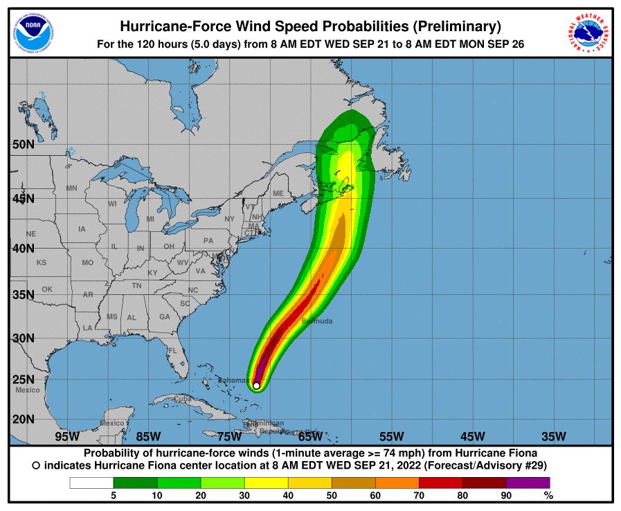
Fiona is Cat 4, Heading North
Fiona is still packing winds of 130 mph. That puts it just inside Category 4 as of Wednesday 9/21/22 at 5PM.
NHC predicts Fiona will clip Bermuda and then head due north. Fiona should hit Canada with topical storm force winds this weekend. In the meantime, pray for people in Bermuda. Cat 4 storms can create catastrophic damage and cause power outages that last for weeks or months.
Invest 98L Expected to Track into Caribbean and Gulf
As of this morning, all major models except one showed 98L moving into the Gulf of Mexico.

Along its route through the Caribbean, 98L will find plenty of warm water. The chart below shows deviation from normal sea surface temperatures for this time of year. This will help fuel the storm.

Most models forecast development of 98L this weekend as the wave reaches the western Caribbean Sea. As the 98L reaches the central Caribbean, shear will begin to decrease. Additionally, oceanic heat content in the Caribbean is some of the highest in the entire Atlantic basin. This deep warm water will help fuel intensification.
NOAA’s HWRF hurricane model shows intensification from a low end tropical storm to major hurricane in a 24-36 hour period. Western Caribbean systems this time of year are notorious for significant deepening in a short amount of time.

Florida More Likely Target Than Texas at this Time
However, Jeff Lindner, Harris County’s meteorologist says that, based on historical norms, hurricanes originating in the Caribbean this time of year tend to move toward Florida … less so toward Texas. The diagram below bears that out. It shows the points of origin and tracks for hurricanes developing in this 10 day period over 165 years.

“Hurricane impacts to the Texas coast this time of year tend to be from the Bay of Campeche and not from the western Caribbean Sea.”
Jeff Lindner, Harris County Meteorologist
Historical norms aside, Lindner says 98L’s longer term track will depend on how it eventually interacts with weather over the eastern U.S. At this time, Lindner believes a frontal boundary will approach the Houston area early next week and help guide 98L east of Texas.
Still, keep your eyes on the Gulf and stay prepared in case something changes.
Posted by Bob Rehak on 9/21/22 at 5PM
1849 Days since Hurricane Harvey

