Tag Archive for: Montgomery County

Plaintiffs’ Engineer Alleges LJA Issued Misleading Studies, Followed Wrong Guidelines in Elm Grove Flooding Case

Fourteen documents filed with the Harris County District Clerk’s office on February 27, 2020, lay out the case of plaintiffs in the Elm Grove flooding case against LJA Engineering, Inc. Lawyers for the plaintiffs named LJA as an additional defendant in their most recent amended petition. Other defendants include Perry Homes’ subsidiaries and contractors: Figure Four Partners, LTD.; PSWA, Inc.; Rebel Contractors, Inc. (which recently changed its name); Double Oak Construction Inc.; and Texasite LLC.

Accusations Specific to LJA

The amended petition alleges LJA:

  • a. Failed to follow the correct drainage guidelines in Montgomery County;
  • b. Failed to provide adequate drainage in the Development;
  • c. Failed to adequately model the Development;
  • d. Failed to adequately report the modeling;
  • e. Removed drainage channels;
  • f. Caused post-development discharges and water surface elevation to increase downstream of the Development;
  • g. Failed to design detention ponds with adequate capabilities for rain events;
  • h. Failed to use the correct hydrology method;
  • i. Failed to design emergency overflows for the detention ponds;
  • j. Failed to notify the Developer Defendants and Contractor Defendants of the importance of the existing levee; and,
  • k. May be liable in other ways described in the consulting engineer’s report.

Consulting Engineer Says LJA Used Outdated Drainage Criteria Manual

The defendants’ consulting engineer, L. David Givler, MSCE, PE, provides the details that back up these claims. Givler is president of Givler Engineering, Inc. Givler’s firm is licensed in Texas to design drainage projects similar to Woodridge Village, which was designed by LJA. A “Certificate of Merit” filed with the court states Givler’s credentials and conclusions. Givler also provides thirteen more exhibits as part of his affidavit. (See links at bottom of post.)

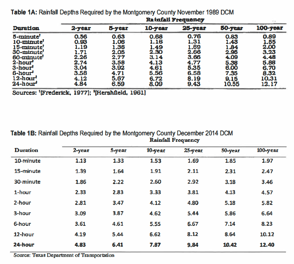
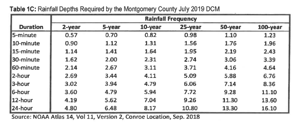
Perhaps Givler’s most explosive finding: LJA based all of its conclusions on an outdated version of the Montgomery County Drainage Criteria Manual (DCM) developed in 1989. MoCo has since updated its DCM twice – in December 2014 and July 2019. Givler asserts that LJA should have used the 2014 version when it submitted its drainage analysis in 2018. The rainfall that MoCo requires engineering firms to design detention basins for have increased since 1989 (see below).

Givler asserts that the increases, along with other other errors and omissions outlined below critically skew modeling results. Ponds that might not overflow based on the 1989 rainfall depths do overflow with 2014 and 2019 rainfall statistics.

Critical Levee Removed, But LJA Did Not Model Effect of That

Givler says in his testimony that grading associated with the construction project removed a levee that had been constructed along the south side of Taylor Gully. “Prior to being removed, the levee had successfully protected the Elm Grove Village Subdivision from flooding,” said Givler. “However, removal of the levee increased the probability for Taylor Gully to overflow southward and to flood the Elm Grove Village Subdivision.”

Givler asserts that the levee successfully protected Elm Grove from flooding in previous extreme events such as Hurricane Harvey, which he characterized as a 330-year storm.

LJA Did Not Use MoCo’s Recommended Method For Modeling Runoff

Mr. Givler also found that LJA did not use Montgomery County’s recommended method for modeling runoff. LJA used something called the Clark’s Unit Hydrograph Method instead of the NRCS Hydrograph Method specified in the 2014 version of the County’s Drainage Criteria Manual. The latter shows significantly higher peak runoff rates, according to Givler. “LJA’s selection of an alternative method (The Clark Method) caused the underestimation of peak runoff rates,” said Givler. “LJA also used low, outdated rainfall depths in its model, which exacerbated the underestimating of the peak runoff rates.”

Givler modeled whether LJA’s designs for the Woodridge Detention Ponds would have successfully held the runoff from the updated drainage criteria manual.

He found that the design for the ponds was “inadequate.” They overflowed. Significantly, Givler also found that LJA underestimated the volume of runoff sent downstream to Taylor Gully.

After May, Protection Not Implemented Against September Storm

“Even after the May 2019 flood, adequate measures had not been implemented to restore the pre­-development level of protection or to prevent a recurrence,” said Givler. “Under Woodrige Village pre­-development conditions, the Elm Grove Village subdivision was safe from flooding during the 330-year Hurricane Harvey rainfall. However, under construction conditions at Woodrige Village, Elm Grove Village was vulnerable to flooding in the 19-year and 92-year rainfall events.”

LJA Did Not Model Effect of Overflow Channel

Givler also noted that LJA’s plan claimed that the 100-year peak stage for the S2 detention pond would be 73.21. That would be high enough to cause water to backup into the grass-lined channel (bottom elevation 68.50) located at the northeast corner of the pond. “Since the highest adjoining ground elevation south and east of the grass-lined channel is approximately 72,” said Givler, “the peak 100-year stage would discharge to Taylor Gully downstream of the project and to the neighborhood east of pond S-2 [North Kingwood Forest]. Such discharges would increase flooding to the residential lots to the east…”

Figure 4 from Page 12 of Givler’s affidavit shows 100-year runoff overflowing Pond S-2 through the Grass-Lined Channel.
The grass-lined overflow spillway in the center of this photo is designed to funnel water from Taylor Gulley into the kite-shaped detention pond (S2) if the concrete channel overflows. But Givler says LJA did not model the opposite. In May and September 2019, water flowed from the gulley into the homes at the bottom left of the frame, as well as homes opposite them on the far side of the gully.

Emergency Overflow System Not Provided

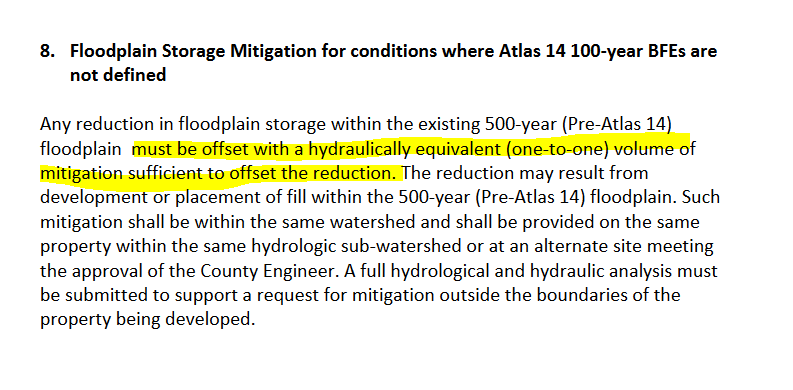
Another problem that Givler found: Section 7.3.13 of the Montgomery County Drainage Criteria Manual (2014 version) requires an emergency overflow system shall be provided “…designed to carry the 100-year allowable detention basin discharge at full-bank conditions… The emergency overflow system shall direct flows into an outfall channel and prevent flow in the direction of developed areas.” (as quoted by Givler).

Even today, the project does not include such an overflow system.

Runoff During Construction More Severe than Ultimate Buildout Conditions

Givler modeled actual construction conditions after the May storm. He found that “…with the project site cleared and stripped of vegetation, runoff conditions were more severe than even the ultimate buildout condition. LJA’s analysis does not address this condition,” he says. His analysis showed that under construction conditions, LJA’s partially-constructed detention ponds were inadequate, unable to contain the May 2019 runoff and the 100-year runoff.”

The temporary construction conditions he says, “caused the ponds to overflow and to discharge runoff to the Elm Grove Village subdivision at a peak rate of approximately 2,110 cubic feet per second.”

Water running through North Kingwood Forest into Elm Grove (background) during Imelda as Keith Stewart evacuates his family.

“LJA Failed to Act as a Reasonably Prudent Engineering Firm”

In his conclusions, Givler alleges that “LJA failed to act as a reasonably prudent engineering firm.” He added, “…three professional engineers and the engineering firm were negligent in the provision of professional services that they rendered, and they committed various actions, errors, or omissions in providing professional services by violating standards required by Montgomery County.”

In Givler’s opinion, LJA failed to comply with Montgomery County standards by:

  • a. Using an alternate (Clark) hydrology method rather than the NRCS method recommended by Montgomery County, resulting in the underestimation of the amount of runoff that the watershed would discharge to the detention ponds.
  • b. Using rainfall depths in the hydrology models which are smaller than what was required by the applicable county standard (2014 DCM) and that are much smaller than recently adopted values (2019 DCM).
  • c. Designing detention ponds, which are too small to contain and too small to detain or attenuate the 100-year design flood.
  • d. Failing to design adequate freeboard for the detention ponds.
  • e. Failing to design adequate emergency overflows for the detention ponds.
  • f. Designing a project, which diverts runoff to properties of others in a harmful and detrimental manner.
  • g. Allowing peak runoff discharges downstream of the project to increase due to the impact of the project and due to the limited effectiveness of the detention ponds.
  • h. Allowing water surface elevations downstream of the project to increase due to the impact of the project and due to the limited effectiveness of the detention ponds.
  • i. Erroneously representing that the project had no impact on downstream areas.
  • j. Failing to notify the contractor of the importance of the existing levee.
  • k. Failing to guide the contractor in a logical construction sequence that would reduce the flood risk during construction.

Violation of Professional Standards and Ethics Also Alleged

Mr. Givler also alleges that LJA and three of its employees violated standards established by the State of Texas and the Texas Board of Professional Engineers in the Texas Engineering Practice Act. “This negligence caused and/or contributed to the endangerment of lives, health, safety, property and welfare of hundreds of people near the project,” he says. They did this, he asserts, “by issuing misleading reports, which failed to indicate the increase in flood potential.”

Questions Remain

“I recognize that additional documents may be produced,” said Givler, “which I will be asked to review and, therefore, reserve the right to add to or to modify this affidavit based on information that may be provided to me at a later time.”

Except for general denials, neither LJA, nor any of the other defendants in this case have responded publicly yet to Givler’s specific allegations.

When LJA and the other defendants make their positions public, I shall review them and give them “equal time.”

The big questions I have at this time are:

  • Why would a firm with LJA’s substantial reputation make the blunders that Givler asserts? Were they pressured into producing a favorable report that made the economics of the project “work”?
  • Five previous developers owned this land and, after studying it, decided not to develop it. That certainly should have raised red flags for LJA and Perry, and caused them to review this closely. There must have been scuttlebutt circulating among local professionals. One engineer I consulted said Friendswood walked away from this property decades ago because it would have been too hard to develop. However, Perry decided to move forward based on dubious studies and incomplete data. Why?
  • What did Concourse Development, Woodbridge 268, Reddy Partnership, Kingwood 575, Lennar Homes of Texas/Friendswood know that Perry Homes did not?

Supporting Documents

Check out the original text of Mr. Givler’s affidavit and exhibits for yourself to ensure I summarized them fairly. His affidavit includes his findings, professional opinions, conclusions and Exhibit 1, his resume.

Exhibit 2 includes the list of documents Givler reviewed in developing his affidavit.

Exhibit 3 includes topographic mapping for construction and pre-construction conditions.

Exhibit 4 includes a topographic map showing the location of the former levee.

Exhibit 5 includes the approval letter by Montgomery County.

Exhibit 6 includes the rainfall values used by LJA.

Exhibit 7 includes a meteorology report.

Exhibit 8 includes reported locations of flooded properties.

Exhibit 9 includes the drainage impact analysis submitted by LJA on March 26, of 2018.

Exhibit 10 includes the drainage impact analysis submitted by LJA on August 28, of 2018.

Exhibit 11 includes Givler’s hydrology model for pre-development conditions.

Exhibit 12 includes Givler’s hydrology model for construction conditions.

Exhibit 13 includes Givler’s hydrology model for post-development conditions.

Exhibit 14 includes LJA’s design for detention pond S2, the one north of Village Springs.

Posted by Bob Rehak on March 8, 2020 based on testimony from David Givler PE

922 Days since Hurricane Harvey and 171 since Imelda

The thoughts expressed in this post represent opinions on matters of public concern and safety. They are protected by the First Amendment of the US Constitution and the Anti-SLAPP Statute of the Great State of Texas.

Hidden Costs of Flooding

When we think about flooding, most of us don’t think beyond the repair costs of homes. But there are more costs to communities that can remain hidden for years. Erosion, for instance, is one of the hidden costs of flooding that we rarely talk about.

You’ve heard me talk about the eroded sediment from sand mines that winds up downstream in the mouth bars of the East and West Forks of the San Jacinto.

The City, County, State and Federal Government have already spent more than $100 million to remove eroded sediment that is blocking the West Fork of the San Jacinto and much more remains.

Likewise, many of you have seen the work being done now to remove approximately 80,000 cubic yards of eroded sediment from Ben’s Branch.

Ben’s Branch became virtually blocked with sand after Harvey. Harris County Flood Control is now removing the excess sediment to restore conveyance of the channel.

We’ve all seen how such eroded sediment can back water up and raise flood levels. And we’ve all seen how much that can cost. Not just from the initial flood, but in terms of remediation.

Look At the Cost of Erosion From the Upstream Side, Too

Ditch erosion can affect homeowners in other ways, too. By threatening their property and community property. Lost property is yet another one of the hidden costs of flooding.

We’ve seen how ditch erosion destroyed riding trails in the Commons on Lake Houston.

Ditch erosion in Commons on Lake Houston. Photo from January 2019.

In Deer Ridge Estates, ditch erosion is creeping inexorably toward back yard fences.

Kingwood diversion ditch where it crosses past Deer Ridge Estates just north of Deer Springs Drive. Photo from Jan. 2019.

On a recent flight down the San Jacinto West Fork, I spotted erosion threatening the back yards of homes still under construction in the new Northpark Woods subdivision.

Erosion can threaten pipelines, too.

Pipelines undermined by erosion at Liberty Materials Mine near Conroe.

Let’s Play Hot Potato

Who is responsible for repairing the upstream erosion when it happens? In Harris County, we’re lucky, we have a flood control district that has assumed responsibility for that. But the ditch two photos above is in Montgomery County. So are the pipelines in the photo above.

Who is responsibly for repairing erosion in these cases? The County? The homeowners? The homeowner association? The developer? The sand mine? The pipelines? A flood control or drainage district? Everyone wants to assume it’s someone else’s problem. No one wants to assume responsibility.

But without someone stepping up, these homes will eventually be threatened. And with the exception noted above, few people or groups are stepping up.

Paul Crowson, a Montgomery County flood activist has posted about this subject on Facebook. Says Crowson, “The county, the flood control district, the neighborhood HOA, the POA, the City, the State, the developers, the engineers … all are passing the blame and responsibility around to each other.”

The problem exists everywhere. Crowson points to the case of Fort Bend County homeowners who are petitioning the Court there to assign responsibility for maintenance of drainage easements.

“These poor people (in the court case) have lost most of their yard, and are in danger of losing their home to the ravages of the drainage easement nightmares,” says Crowson. “Those nightmares are growing every day and will eventually swallow them and their home. Why does it matter to you? I’m thinking right now of Roman Forest, Tavola, New Caney, and Montgomery County.”

It’s Easier to Keep Up Than Catch Up

I would argue that it’s cheaper to prevent a disaster in the making than to remediate a disaster after the fact. Remember those homely homilies your parents and grandparents tried to instill in you? An ounce of prevention is worth a pound of cure. A stitch in time save nine.

Congressman Dan Crenshaw says the Navy Seals have a similar saying for those who fall behind on those long training runs they take. “It’s easier to keep up than catch up.” They’re all true! And the same holds true for deferred maintenance.

When Deferred Maintenance Turns into a Disaster Area

Montgomery County does not have a flood control district. Nor does it seem especially eager to address problems, such as those in the photo above.

As we saw with the mouth bar on the West Fork that had been building up under water for decades, maintenance can be deferred for only so long.

Then a monster flood comes along like Harvey. It finds the weak points in systems…and boom. Deferred maintenance turns into a disaster area.

Posted by Bob Rehak on 2/28/2020 with input from Paul Crowson

913 Days after Hurricane Harvey

Detention Pond Construction: Montgomery vs. Harris County

Below are aerial images from two new developments under construction. They show two detention ponds in two different counties. Can you tell which is in Montgomery County and which is in Harris County? I took both photos on the same day, 2/13/2020.

Detention Pond A
Detention Pond B

Clue

Look where the grass has established itself:

  • In A, the land was cleared before the detention pond was completed.
  • In B, the detention pond was completed before the land was cleared.

And the Answer Is…

If you guessed that Pond A is in Montgomery County, you guessed correctly. Pond A is in Woodridge Village, just north of Sherwood Trails and Elm Grove. It is their S1 detention pond (first southern).

Pond B is in Harris County just north of Bush Intercontinental Airport and Mercer Botanic Gardens.

How You Can Tell

Montgomery County does not require developers to install detention ponds before they clearcut the whole development. So they sometimes come long AFTER clearcutting.

Also, even though Page 44 of Montgomery County’s Drainage Criteria Manual says that “slopes must be revegetated immediately after construction to minimize erosion,” no one apparently enforces the regulation. The sides of Pond A have gone without grass for about a year. See close up below.

Erosion on the sides of Pond A shown above, the Woodridge Village S1 detention pond.

All 268 acres of Woodridge Village have been clearcut for the better part of a year. Meanwhile Perry Homes and its engineering firm LJA are just now taking bids on additional detention ponds for the northern section. And the sides of Pond A still have yet to sprout grass.

Harris County Regs Differ

Note in the Pond B photo how the sides of the channel have been stabilized with grass before the developer has even finished clearing the land.

Harris County employs low-impact development procedures (LID). Harris County Stormwater Quality Management regulations discourage clearcutting giant sites like Woodridge Village all at once. See section 4.2.3.1, Stormwater Pollution Prevention (SWPPP) During Construction.

The text states, “The clearing, grubbing and scalping (mass clearing or grading) of excessively large areas of land at one time promotes erosion and sedimentation problems. On the areas where disturbance takes place the site designer should consider staging construction [emphasis added], temporary seeding and/or temporary mulching as a technique to reduce erosion. Staging construction involves stabilizing one part of the site before disturbing another [emphasis added].

Two Different Approaches

You would think that preventing erosion would be cheaper than cleaning it up. Why do a job once when you can do it twice? Right?

Close up of remediation work in Pond A, from a slightly different angle. Photo taken 2/13/2020.

Evidently, Perry Homes prefers it that way. Last Thursday, I spotted men digging out the pilot channel of Pond A and restoring slopes…again. This was at least the third or fourth time. No wonder those Perry Homes are so expensive.

Posted by Bob Rehak on 2/16/2020

901 Days After Hurricane Harvey and 150 after Imelda

The thoughts expressed in this post represent opinions on matters of public concern and safety. They are protected by the First Amendment of the US Constitution and the Anti-SLAPP Statute of the Great State of Texas.

When Is a Detention Pond Not a Detention Pond?

On a flyover of the Harris/Montgomery county line last month, I spotted something unusual: a detention pond with an outlet bigger than its inlet. And it was in Woodridge FOREST. You may remember that after Imelda, Woodridge Forest advertised homes that did not flood on signs posted in nearby intersections…around downstream homes that did flood!

Detention Pond that Isn’t

Wide shot, looking east toward St. Martha’s Catholic Church and Kingwood Park High School. Photo taken 1/20/2020.

Below is a closeup of the suspect pond cropped from the image above.

Water flows from bottom left to upper right in this image. During Harvey, the outlet for this detention pond blew out. Imelda enlarged it even more. No one has repaired it, meaning it retains no water in a flood.
Water from this part of the subdivision does not even go through the pond. Note the location of this outlet in the photos above and below.
Satellite image shows clearer comparison. Detention pond has bigger outlet than inlet and a creek that runs around it.

Detention ponds usually work by capturing water coming in a fast rate, storing it, and releasing it at a slower rate that minimizes downstream flooding.

From Montgomery County Drainage Criteria Manual

This pond provides very little, if any detention capacity. In fact, Ben’s Branch runs BOTH around and through it!

The berm that forms the north side of the pond in the image above does little more than take up valuable space in the flood plain.

On its way from 59 to Woodland Hills, Ben’s Branch goes through a series of “detention ponds” along the southern edge of Woodridge Forest. What purpose does of this one serve? And are the others doing their job?

Developers/HOAs Responsible for Maintenance

In Montgomery County, developers or HOA’s must maintain their own detention ponds (see section 7.2.8). But do they? No one seems to inspect their work. The damage to this pond initially happened after Harvey, almost 900 days ago. Then Imelda damaged it more, almost 150 days ago.

The pond should also have a 30-foot wide maintenance road around it (also section 7.2.8), but does not. The developer built the pond in 2016, but no one seems to have noticed the absence of the maintenance road yet. That missing maintenance road might have helped in the repair of the pond after Harvey.

And the “Rub-Your-Nose-In-It” Award Goes To…

Who knows how much this pond could have helped reduce flooding on May 7th and September 19th last year?

Many who flooded in North Woodland Hills and Bear Branch sure would like to know.

The truly appalling thing about this: shortly after Imelda, Woodridge Forest posted signs in the area informing buyers, “We don’t flood.” Well, when you’re not retaining all the water you should…

Montgomery County is on an unsustainable path. Every week, I get complaints from Montgomery County residents about flooding there. MoCo is already starting to reap what it has sown. Someday, MoCo, too, will be downstream from another rapidly growing county. And then the tragic precedent MoCo has set will make payback inevitable.

Posted by Bob Rehak on 2/13/2020

898 Days since Hurricane Harvey and 147 since Imelda

The thoughts expressed in this post represent opinions on matters of public concern and safety. They are protected by the First Amendment of the US Constitution and the Anti-SLAPP Statute of the Great State of Texas.

When Measured by Growth of Impervious Cover, Texas Has 9 of Top 20 Counties in U.S.

According to a recent New York Times article, nine of the 20 counties in the U.S. that have experienced the most development the last decade are in Texas. Prominent among them is Harris County. The article does not cite population growth. Rather, it relies on computer analysis of satellite imagery that detects the growth of impervious cover.

Analysis of Satellite Imagery Shows Land Newly Paved or Topped With Buildings

The Times cites the work of Santa-Fe-based Descartes Labs, which positions itself as a data refinery. The company trained a computer model to automatically identify newly impervious surfaces — land that appears paved or topped with buildings — in satellite imagery. It then produced dozens of paired images that show the effects of development. It also produced a map that shows where that development took place.

This Descarte map clearly shows the pattern in Texas. Each of the major cities looks like a bullet hole in the map with development splashing out ward…a ring of concrete.

Return of Suburban and Exurban Growth

The data suggests that the growth of suburbs and exurbs has returned. There was a brief hiatus of suburban development after the housing bust in 2008, which saw people returning to the inner city. But that trend appears to be over, according to this analysis.

I’m not sure if this should be a source of pride, alarm or both.

Texas Grows While Other Areas Lose Population

Many Rust Belt cities are experiencing population shrinkage. That presents another set of problems altogether. The Times article shows how several northern cities, including Detroit, are clearing thousands of dilapidated and abandoned homes. In the process, they are restoring pervious (natural) cover.

As luck would have it, another article in The NY Times the next day talked about a slowdown in U.S. population growth. Population grew at its slowest pace in decades in 2019. A decline in the number of new immigrants, fewer births and the graying of America accounted for the decline, which the Census Bureau estimated.

Given slow population growth on the national level, local growth in Texas and Houston must come from migration. I’m not talking about foreign immigration. I’m talking about one area attracting residents and businesses from another.

Texas Has Seven of Fifteen Fastest Growing Cities in U.S.

In marketing, if the market itself is not growing, the only way for a company to grow is to steal share from its competitors. And that is exactly what Texas seems to be doing. Markets such as New York and California are losing population while Texas gained more than 14% in the last decade. From 2010 to 2018, Texas had the largest population growth in America: 3,555,731.

Texas also had 7 of the top 15 fastest growing cities in the country between 2017 and 2018.

So clearly, from a marketing point of view, Texas must be seen as a desirable place to live by many people. We’re doing many things right.

Can Texas Meet the Challenge of Rapid Growth?

But in my 45 year career in marketing and advertising, I have seen many instances where companies had record growth one year only to have record losses later. It comes down to how you manage growth.

Can you deliver what you promise and keep product quality up as you grow?

Many areas can. Many areas can’t.

County officials face a conundrum: growing rapidly while maintaining quality of life. You want to attract growth, but you don’t want to be overwhelmed by it.

Montgomery Vs. Fort Bend Counties: Strategic Differences

Some compete for growth by relaxing regulations. For instance, this video from the East Montgomery County Improvement District boasts, “We don’t have rules that confine us.” The no-hassle upfront, anything-goes, follow-your-dream approach tempts many, especially those coming from other areas with onerous regulations.

Meanwhile, other fast-growing counties, such as Fort Bend, are adopting new flood plain regulations, designed to protect the quality of life they are selling.

Tougher Fort Bend County Regulations Went Into Effect New Year’s Day.

As of 1/1/2020, Fort Bend County adopted new Atlas 14 rainfall statistics and updated their drainage criteria manual accordingly to protect new homes AND existing downstream developments. Fort Bend is the fastest growing county in the region.

There you have it. Two opposite ends of the spectrum.

It will be interesting to see the outcomes that these two development strategies produce ten years from now.

Posted by Bob Rehak on 1/2/2020

856 Days since Hurricane Harvey and 104 since Imelda

Kingwood Residents Go One on One with Flood Experts; Huffman Up Next

Yesterday’s open house at the Kingwood Community Center seemed to be a hit. The SJRA, City of Houston, Harris County Flood Control and Montgomery County – all partners conducting the San Jacinto watershed study – had the subject-matter experts actually conducting the study there. The open house format gave residents a chance to interact with them one on one, tell their flood stories, and discuss possible mitigation scenarios.

Difference Between Listening and Learning

As one resident said, “I got more from 45 minutes here than a dozen town hall meetings.” I appreciate the town hall meetings, but he was right.

Quality one-on-one interaction made the difference between listening and learning.

I suspect the professionals there felt the same way. They came seeking input and they got it.

It felt like a collaboration, not a presentation.

For example, I got to quiz Adam Eaton, one of the engineers working to add more gates to the Lake Houston Dam. Finding hard information about this project has been difficult. But Mr. Eaton provided it. See budget, timeline and project milestones below.

Budget, timeline and project milestones for Lake Houston Dam Spillway Improvement Project.

Engineers hope to finish design and receive environmental approval by mid-2020. From there, TDEM and FEMA will review the plans and then hopefully release funds for construction. I asked Mr. Eaton whether there was a chance construction could NOT be approved. Answer: It’s possible, but very unlikely.

Details in Big Picture Context

I also talked at length with Matt Zeve, deputy executive director of Harris County Flood Control. Zeve, who has studied channel hydrology all his life, helped me understand why upstream communities don’t automatically benefit from projects that decrease downstream flood levels. He also helped me understand big picture issues, some of which weren’t even on my radar yet. For instance, how the extension of Highway 99 could affect flooding in Liberty County and on the East Fork twenty years from now.

David Parkhill, an author of the Brown & Root report published in 2000 was there, too. They called it a Regional Flood Protection Study back then. But it had the same objectives as the SJR Master Drainage Plan: to identify flood mitigation projects that will make a difference. Mr. Parkhill helped put the current effort in historical context. He was both fascinating and helpful!

Huffman Meeting on Thursday, 3-7:30 at May Community Center

If you missed the Kingwood meeting on Tuesday, I urge you to attend the Huffman meeting tomorrow. It will have all the same information and experts that the Kingwood meeting had. And it will be your last chance to visit an open house in this area until the next round of public comments next Spring.

The quality of input you give in this process will determine the quality of output you get.

  • Thursday, December 19, 2019
  • 3:00 p.m. to 7:30 p.m.
  • May Community Center
  • 2100 Wolf Road
  • Huffman, Texas 77336

The open house will include information about the following projects, studies, and efforts:

  • San Jacinto Regional Watershed Master Drainage Plan
  • Kingwood Area Drainage Analysis
  • Huffman Area Drainage Analysis
  • Spring Creek Watershed Planning Study
  • Luce Bayou Watershed Planning Study
  • Willow Creek Watershed Planning Study
  • Jackson Bayou Watershed Planning Study
  • Cedar Bayou Tributary Analysis
  • SJRA-led Projects 
  • City of Houston-led Projects
  • Harris County Permit Office
  • Harris County Engineering Department – Recovery and Resiliency Division
  • Hurricane Harvey Repair Efforts
  • Information about services provided by Harris County Flood Control District, Harris County and Montgomery County

The open house will last from 3:00 p.m. to 7:30 p.m. The format lets attendees arrive and participate at their convenience. No formal presentation will be made

Provide Input on Master Drainage Plan

You can comment on the plans at the meeting in Huffman and throughout the duration of the study. 

If you can’t attend in person, mail comments to:

  • Harris County Flood Control District
  • 9900 Northwest Freeway
  • Houston, Texas 77092
  • Attn: San Jacinto Regional Watershed Master Drainage Plan

Alternatively, you may submit comments online.

For more information about the San Jacinto Regional Watershed Master Drainage Plan, visit www.sanjacstudy.org.

Posted by Bob Rehak on 12/18/2019

841 Days since Hurricane Harvey and 90 since Imelda

The Perfect, Perpetual Production-Consumption Cycle

The taxpayer-funded Grand Parkway (State Highway 99) extension will make many people happy. Proximity to transportation drives home-buying decisions. People eager to “get away from it all” will find the lure of saving 10 minutes on a longer commute irresistible. They will marvel at all the trees around them and speak with pride about their growing community in the forest.

Eastward expansion of SH99 from I-69.

It will also make the sand miners happy. It takes lots of sand to make concrete.

West Fork San Jacinto mine

Developers and homebuilders will take advantage of lax regulations in Montgomery County to boost their profitability.

Perry Homes’ Woodridge Village

And the flooding, caused by all the environmental destruction, means that downstream residents get to remodel their homes. Or move farther out to avoid future flooding. At which point the cycle will repeat itself in a few years.

Elm Grove Home below Perry’s Woodridge

From a marketing point of view, it’s a perfect, perpetual production-consumption cycle. How could you possibly improve it?

Posted by Bob Rehak on 12/8/2019

831 Days after Hurricane Harvey and 79 Days after Imelda

The thoughts expressed in this post represent opinions on matters of public concern and safety. They are protected by the First Amendment of the US Constitution and the Anti-SLAPP Statute of the Great State of Texas.

Reminder: Public Open House for San Jacinto Regional Watershed Master Drainage Plan

From December 16 -19, Harris County Flood Control District (HCFCD) and its partners will hold a series of open houses to familiarize people with the San Jacinto Regional Watershed Master Drainage Plan (SJMDP). Residents may also give input at the meetings.

HCFCD, Montgomery County, the City of Houston, and the San Jacinto River Authority (SJRA), will host the open houses to provide information about the regional plan and other study efforts underway in the San Jacinto River watershed. Keeping them all straight is difficult!

Timeline for Master Drainage Plan

The SJMDP study effort began in April 2019 to identify future flood mitigation projects that can be implemented in the near- and long-term to reduce flood risks to people and property throughout the San Jacinto River regional watershed.

Timeline for the San Jacinto River Watershed Master Drainage Plan as of 12/4/2019. Source: HCFCD.

More about the Master Drainage Plan

The SJMDP is jointly funded with 75 percent from the Federal Emergency Management Agency (FEMA) Hazard Mitigation Planning Program and 25 percent from the four local partners.

Overall, the SJMDP aims to provide an up-to-date technical basis to identify flooding vulnerabilities for existing infrastructure and impacts from future growth to improve flood resiliency within the watershed. The SJMDP should complete in fall 2020.

The SJMDP study area covers nearly 3,000 square miles located in seven different counties and includes approximately 535 miles of stream.

Open House Dates/Times/Content

Flood Control will solicit public input and participation throughout the study. The first series of public open houses for this study effort will be held on the following dates and locations:

Tomball
  • Monday, December 16, 2019
  • 3:00 p.m. to 7:30 p.m.
  • Lonestar Bekendorf Conference Center
  • 30555 Tomball Parkway
  • Tomball, Texas 77375
Kingwood
  • Tuesday, December 17, 2019
  • 3:00 p.m. to 7:30 p.m.
  • Kingwood Community Center
  • 4102 Rustic Woods Drive
  • Kingwood, Texas 77345
Huffman
  • Thursday, December 19, 2019
  • 3:00 p.m. to 7:30 p.m.
  • May Community Center
  • 2100 Wolf Road
  • Huffman, Texas 77336

All three meetings will have the same materials and format. Each open house will include information about the following projects, studies, and efforts in the region:

  • San Jacinto Regional Watershed Master Drainage Plan
  • Kingwood Area Drainage Analysis
  • Huffman Area Drainage Analysis
  • Spring Creek Watershed Planning Study
  • Luce Bayou Watershed Planning Study
  • Willow Creek Watershed Planning Study
  • Jackson Bayou Watershed Planning Study
  • Cedar Bayou Tributary Analysis
  • SJRA-led Projects 
  • City of Houston-led Projects
  • Harris County Permit Office
  • Harris County Engineering Department – Recovery and Resiliency Division
  • Hurricane Harvey Repair Efforts
  • Information about services provided by Harris County Flood Control District, Harris County and Montgomery County

The open houses will last from 3:00 p.m. to 7:30 p.m. The free-flowing meetings will have informational displays. Staff will answer questions. The open house format lets attendees arrive and participate at their convenience. No formal presentation will be made

To Provide Input on Master Drainage Plan

You can comment on the plans at the public open houses and throughout the duration of the study.

If you can’t attend in person, mail comments to:

  • Harris County Flood Control District
  • 9900 Northwest Freeway
  • Houston, Texas 77092
  • Attn: San Jacinto Regional Watershed Master Drainage Plan

Alternatively, you may submit comments online.

For more information about the San Jacinto Regional Watershed Master Drainage Plan, visit www.sanjacstudy.org.

Posted by Bob Rehak on 12/4/2019

827 Days since Hurricane Harvey and 76 since Imelda

What Went Wrong, Part IV: Perry Homes Develops Flood Plain That Wasn’t

Chapter 9 of the Montgomery County Drainage Criteria Manual discusses development in flood plains. Perry Homes and LJA Engineering somehow “overlooked” many of the points in this chapter. A flood plain ran through the property, but FEMA had not yet mapped it. LJA used that as an excuse to claim none existed.

Notice how flood plain mapping stops at county line. Perry Homes has the undeveloped property along and above the county line. Color code: Cross-hatched = floodway; aqua = hundred year flood plain; brown = 500-year flood plain. Source: MoCo Maps

Unfortunately, physical boundaries of flood plains do not observe political boundaries. Taylor Gully bisects this property, if you look at the flood maps, it magically defies flooding on the MoCo side of the county line.

Montgomery County Regulations Affecting Flood Plains

Below are guidelines from the Montgomery County Drainage Criteria Manual that Perry Homes would have had to follow had the property been mapped.

From Section 9.1.1 Floodplain Regulations:

“No fill or encroachment is permitted within the 100-year floodway which will impair its ability to discharge the 100-year peak flow rate except where the effect on flood heights has been fully offset by stream improvements.” [Emphasis added.]

“Placement of fill material within the floodplain requires a permit from the County Drainage Administrator. Appropriate fill compaction data and hydrologic and hydraulic data are required before a permit will be issued.”

From Section 9.1.2 Floodplain Development Guidelines and Procedures

“Construction within the floodway is limited to structures which will not obstruct the 100-year flood flow unless fully offsetting conveyance capacity is provided.”

  • “The existing designated 100-year floodplain and floodway should be plotted on a map of the proposed development.”
  • “The effect of the proposed development and the encroachment into the flood plain area should be incorporated into the hydraulic model and the resulting flood plain determined.”
  • “Careful consideration should be given to providing an accurate modeling of effective flow areas taking into account the expansion and contraction of the flow.”
  • “Once it has been determined that the proposed improvements adequately offset the encroachment, a revised floodway for the stream must be computed and delineated.”
From Section 9.2 Downstream Impact Analysis

“Pursuant to the official policy for Montgomery County, development will not be allowed in a manner which will increase the frequency or severity of flooding in areas that are currently subject to flooding or which will cause areas to flood which were not previously subject to flooding.”

What LJA Said About Perry Homes’ Project

On Page 1-2 of its Drainage Analysis, LJA Engineering explicitly states, “As shown on Exhibit 3, the proposed development is outside the 100-year floodplain.”

Phyllis Mbewe, P.e., CFM, LJA Project Manager – Hydrology and Hydraulics
LJA Exhibit 3 shows the floodplain stopping at the county line. LJA also did its best to make the .2 percent risk area blend into the area of minimal flood risk. This visually minimizes the amount of floodplain bordering MoCo, so the abrupt stoppage at the county line becomes less visible. Source: LJA.

Ms. Mbewe then states in her conclusion, “Based on these findings, the proposed development of the 268-acre tract creates no adverse drainage impacts for events up to and including the 100-year event.” [Emphasis added.]

What Does “No Adverse Impact” Really Mean?

People often twist the definition of terms you think are self evident. Especially in legal, technical, and political contexts.

To me, “No Adverse Impact” should mean, “Downstream people who didn’t flood before won’t flood after development.” That’s what section 9.2 states explicitly.

But when I talked to a flood professional, I got a different answer. To that person, “no adverse impact” meant, “the amount of water flowing across the property did not increase after development.” Much narrower! And seemingly contradictory to the spirit of 9.2.

“Floodplain” Definition Shocked Me

But that person’s definition of floodplain really shocked me. To me, floodplain means “the area adjacent to a stream that fills with floodwater after a very heavy rain.” But the professional told me I was WRONG. To the professional, a floodplain was “an area on a map that FEMA designated a floodplain for insurance purposes.”

In that person’s mind, because FEMA had never mapped the area in question, a floodplain did NOT EXIST. Whether or not the area flooded!

To me, that’s like saying an apple is something you see in a Kroger’s flyer, not something you eat. We’re talking about the difference between a symbol of something and the reality of it.

This discussion proved once again that words and phrases have different meanings that depend on the social context of usage.

In the minimum compliance environment of Montgomery County, LJA and Perry Homes argued that there was no floodplain. They found someone in the county engineer’s office who agreed with them…or was told to agree with them.

FYI, the official FEMA definition says, “Any land area susceptible to being inundated by floodwaters from any source.”

Consequences of Overly Narrow Definition

So did Elm Grove flood because Perry Homes, LJA and Montgomery County did not enforce the floodplain regs in section 9.2 of the Drainage Criteria Manual?

  • They certainly did not offset peak flows with stream improvements.
  • They did not plot the REAL-WORLD floodway and floodplain on a map of the proposed development (see above).
  • LJA did not incorporate encroachment into the floodplain in its hydraulic modeling, because they denied a floodplain existed.
  • Neither did LJA provide “an accurate modeling of effective flow areas taking into account the expansion and contraction of the flow.”
  • Finally, LJA did not compute, revise and delineate the floodway for the stream.

Had they done all these things, perhaps people would have seen that downstream homes that had never flooded were now subject to greater flood risk. But that’s really something for the jury to decide. And it would require FEMA to model the floodplain after the fact.

But like the narrow definition of floodplain, this whole discussion symbolizes a bigger problem.

How Do You Fix a Permissive, Minimum-Compliance Environment?

LJA had an obligation to its client and a higher one to the public that it ignored in my opinion.

Perry Homes could have demanded honest answers from its engineers, not the ones they wanted to hear.

FEMA could label areas like Woodridge Village “UNMAPPED”. This would send a signal to potential home buyers if sellers tell them they’re NOT in a floodplain. That might make developers think twice.

Home buyers need to demand integrity in this process. They need to ask better questions. They need to learn more about flooding.

But at the end of the day, Montgomery County Commissioners must define the kind of future they want. Do they want constant flooding? Or not. Because right now, they’re competing with other areas for new development on the basis of willful blindness and self-serving definitions.

Thirty years down the road, when it’s too late to fix the infrastructure problems they ignore today, MOCO residents will be paying the price. Some, who have flooded repeatedly, might argue they already are.

Posted by Bob Rehak on 8/26/2019 with help from Jeff Miller

820 Days after Harvey and 69 since Imelda

The thoughts expressed in this post represent opinions on matters of public concern and safety. They are protected by the First Amendment of the US Constitution and the Anti-SLAPP Statute of the Great State of Texas.

Lake Conroe Lowering Benefits MoCo Residents, Too; More Than 1100 Flooded on West Fork During Harvey

Lake Conroe residents organizing opposition to the SJRA’s lake lowering policy have found it easy to “blame” Kingwood for their inconvenience. Kingwood is an affluent community in another county. But the Lake Conroe people ignore more than 1100 homes between Kingwood and Lake Conroe in Montgomery County (MoCo) that also flooded.

The lake lowering reduces downstream flood risk by creating extra capacity within the lake during months with the heaviest rainfall. It is a temporary measure until flood mitigation measures can be completed that help protect the Lake Houston Area.

ESRI GIS Database Shows Counts of Damaged MoCo Homes

ESRI operates a Montgomery County GIS (geographic information system) database called the Harvey Story Map. (Unfortunately, this may not work with all versions of Safari. Try Chrome if you have trouble.) Clicking on Section 12 shows the location of homes that flooded during Harvey in MoCo.

As you to zoom, you can see counts of flooded structures within the visible area. For instance, around Lake Conroe, 292 homes flooded during Harvey. The map below shows the location of those homes.

292 homes flooded on Lake Conroe during Harvey. Lake lowering gives them an extra buffer against flooding.

If you continue to zoom in, you can even see how individual houses fared in other floods as well.

Below are six screen captures that give you a sampling of what you will find. This first area is just below the Lake Conroe dam where 30 homes flooded during Harvey.

Below is River Plantation, just downstream from I-45. Put your water wings on, Bucko! The count here: 527.

Here are four more subdivisions farther downstream.

The West Fork subdivisions shown above had 1159 flooded structures during Harvey. But more homes flooded than in these six images. For starters, there were the 298 homes around Lake Conroe itself.

So, to the 4,484 homes that flooded in Kingwood, Humble and Atascocita on the West Fork, add these and more.

I’m not sure how many people have waterfront lots on Lake Conroe, but is their boating convenience really worth risking the possibility of flooding even a subset of these homes again?

Posted by Bob Rehak on 11/24/2019

817 Days after Hurricane Harvey