On Sunday morning, Jeff Miller, an Elm Grove resident who lives near Woodridge Village, reported 5.5 inches in his rain gage. That compares to a 6.24 inch rain that fell on Woodridge on May 7, 2019, when hundreds of homes in Elm Grove and North Kingwood Forest flooded. Also, Woodridge falls about 40% short of current Atlas-14 standards required to hold back floodwater from a 100-year storm.
Other important factors came into play last weekend that should relieve some of residents’ anxiety and help explain what happened.
First, remember that on May 7, 2019, Perry Homes’ contractors had clearcut 268 acres, but had barely begun work on detention ponds. Only one of five was complete.
Second, the intensity of the May 7, 2019 rain was higher than last weekend’s. On May 7, 6.24 inches fell in 5 hours. Last weekend, 5.5 inches fell in 9 hours.
Third, in 2019, the S2 detention area had been partially excavated but didn’t have any outflow control restrictions installed yet. So it didn’t really function as a detention pond.
Fourth, contractors had destroyed a berm between Elm Grove and Woodridge, and filled in a natural stream on Woodridge. Both have since been replaced.
I took the photos below Sunday morning between periodic sprinkles, several hours after heavy rain stopped. They show how the current Woodridge Village detention handled the storm. All ponds were well within their banks. One was empty.
The triangular pond on the left is N2. N1 is out of sight above it. The two ponds on the right are S1 (foreground) and S2 beyond it. N3 is out of sight at the top of the frame.
S2 was about halfway to two-thirds full.
The tail of S2 is already silting in but had plenty of room to spare.
N3 Pond on eastern edge of property was supposed to have had an outflow control device but never got one.
The Junction where water from all five ponds comes together before flowing into Taylor Gully. N3 is at top of frame.
Reverse angle shot of the Junction with Taylor Gully in the background. Note how high the detention ponds are compared to the gully.The areas that flooded so badly in 2019 are just beyond the ponds.
Water coming from the big trianglar N2 pond now has to go through these twin culverts which were almost completely inundated.
Wider shot shows volume of water backed up in N2.
Only N1 in the NW corner of Woodridge was totally dry. The outflow capacity is much greater than the inflow. So this pond provides no detention benefit whatsoever. Local resident Jeff Miller says he has NEVER seen standing water in this pond.
The thoughts expressed in this post represent opinions on matters of public concern and safety. They are protected by the First Amendment of the US Constitution and the Anti-SLAPP Statute of the Great State of Texas.
https://i0.wp.com/reduceflooding.com/wp-content/uploads/2022/01/20220109-DJI_0370-2.jpg?fit=1200%2C799&ssl=17991200adminadmin2022-01-11 16:46:412022-01-11 17:14:16Woodridge Village Detention Ponds Passed Sunday Test, But…
Morgan Lumbley, Montgomery County’s Disaster Recovery Manager, will hold community outreach meetings in Spring, Conroe and Splendora in the next 10 days to explain buyout options for flood victims. “It is my hope that through positive engagement we can provide the ability for homeowners to relocate out of harm’s way,” said Lumbley.
See specifics about times, dates and places in the poster below.
Anybody in Montgomery County may attend any meeting. Choose the most convenient.
The primary purpose of the meetings will be to explain FEMA’s 2021 Flood Mitigation Assistance (FMA) program, but Lumbley will also explain HUD’s Community Development Block Grant Disaster Recovery (CDBG-DR) buyout program.
If you’re a Montgomery County resident and you’ve ever wondered whether you qualified for a buyout, whether you could get fair compensation for your home, or how you could apply, these meetings are for you.
The meetings will cover:
Who qualifies (eligibility requirements)
For which type of assistance (FEMA vs. HUD)
How long it takes
The application process
How homes are valued
How to get help filling out the forms if you need it
Importance of Meetings and Timing
Lumbley described the meetings as community outreach. She needs to identify properties owners interested in buyouts and determine their eligibility. Once she does that, she will apply to FEMA for an FMA grant (Flood Mitigation Assistance) equal to the total value of all homes that quality.
The application process happens once a year. If interested, learn how to apply now.
The FEMA Flood Mitigation Assistance Grant basically has two requirements.
It has to be a severe repetitive loss or a just a repetitive loss property, as indicated by the National Flood Insurance Program (NFIP).
You must currently have a NFIP policy backed by FEMA. Private insurance is not eligible.
Lumbley cautions that getting a buyout can take years. “It’s not a tomorrow-type thing,” she said. “We may not have anything final for another year and a half to two years. So we’ll talk about that first. Then realizing that some may not qualify for FEMA’s program, we will also talk about HUD buyouts.”
FEMA Applications Due Back November 15th
Once Lumbley determines the number of homes that meet requirements, she will build a budget around those eligible homes. “We are basically saying to FEMA, ‘If you give us this money, these are the homes that we’re going to buy out. That’s how we establish the budget.”
“It all comes down to how many eligible individuals want to participate,” said Lumbley. “We will submit the county’s application to FEMA with five or a 100 homes.”
Definitions of Repetitive Loss and Severe Repetitive Loss
“Very specific definitions exist for repetitive loss and severe repetitive loss properties,” she said. “A repetitive loss property has had flood related damage on two occasions in which the cost of repairs averaged together equal or exceed 25 percent of the market value of the structure – at the time of the floods.Severe repetitive loss properties have had four or more separate floods, with each claim being $5000 or more. And at least two of those claims have to be within a 10 year period.”
“Another way to qualify as a severe repetitive loss is to have at least two separate NFIP claims that that total more than the market value of the structure,” she added.
Valuation
“We will write the county’s 2021 FEMA grant application to reflect current market value of homes. If FEMA approves that, applicants would get whatever the competitive open market value is on the day that the appraiser goes out to appraise it.”
HUD grants are based on pre-disaster valuation. “So it goes back to the disaster on which funding is based,” said Lumbley. “We’re currently working off the 2015/2016 floods and Hurricane Harvey. So what value did the home have before the storm hit, minus any funding that the owner might have received that did not go back into the home as it was intended?”
Eligible Years Vary by Type of Grant
Community Development Block Grants from HUD are disaster specific. So to be eligible for a HUD grant, you must have been damaged during one of those ‘funded storms,’ such as 2015, 2016 or Harvey.
But FEMA FMA grants are not disaster based. So as long as you have a current NFIP backed flood insurance policy and you meet the definitions of repetitive loss or a severe repetitive loss, you could to be eligible. For instance, maybe you flooded four times in 1978, 1982, 1994 and 2001.”
it gets complicated. If you’re interested in a buyout, the time to explore it is now – at one of these meetings – and the person to ask is Lumbley.
If you know someone interested in a buyout, make sure he/she attends one of these meetings. Please share this post with others in Montgomery County.
Posted by Bob Rehak on 11/3/2021 based on information from Morgan Lumbley
1527 Days since Hurricane Harvey
https://i0.wp.com/reduceflooding.com/wp-content/uploads/2021/11/20211027-image0.jpg?fit=1200%2C1006&ssl=110061200adminadmin2021-11-03 18:41:462021-11-03 20:23:45Montgomery County Holding Three Meetings for Flood Victims Interested in Buyouts
For this round of funding, the TWDB selected 19 sub-applications from local government entities. After screening, FEMA eliminated 6 and identified 13 “for further review.”
Here’s a summary from the TWDB of what they will vote on.
Harris County Drainage Project in Bear Creek Village
Bear Creek Village is located on the west side of the Addicks reservoir near Highway 6. This is an $11.3 million project of which the federal government would pay $8.5 million.
The Harris County project would mitigate 1,421 structures. The current storm sewer system is designed for a 3-year event and is inadequate to collect and drain extreme event runoff. The proposed drainage improvements are intended to provide an additional flow path, so that excess storm water is contained within street right-of-way to an outfall. The project will incorporate a combination of channel construction, street regrading, and enhancement of outfalls. The project has a positive Benefit-Cost Ratio of 1.09.
Harris County Flood Control District Single-Family Home Acquisitions
Total cost = $16.7 million with federal government paying $14.7 million.
Harris County Flood District seeks to mitigate 61 structures: 23 Severe Repetitive Loss structures, 17 Repetitive Loss structures, and 21 at risk of continual future flooding. HCFCD would acquire and demolish structures, then convert the land to open green space. The project has a positive Benefit-Cost Ratio of 1.09.
Harris County Flood Control District Commercial Acquisition
This is a $3.7 million buyout with the federal government picking up the whole tab.
Harris County Flood Control District wants to buy out a hotel on the east freeway with a severe repetitive loss history. HCFCD would demolish the property and convert the land to open green space. The project has a positive Benefit-Cost Ratio of 1.84. The grant application notes that since 1979, FEMA has paid out $8 million in NFIP claims on this property.
City of Houston Single-Family-Home Elevation Project
Total Cost $1.5 million (all paid by federal government) to elevate 5 severe-repetitive-loss homes ($300,000 each). All would be elevated at least 2 feet above the 500-year floodplain. That would hopefully reduce or eliminate future NFIP claims. The project has a positive Benefit-Cost Ratio of 1.1.
Jersey Village Single-Family-Home Elevation Project
Total Cost $4.9 million with federal government covering $400,000.
Jersey Village seeks elevate 16 structures: 10 are Severe Repetitive Loss, five Repetitive Loss and one at risk of continual future flooding. Elevation will raise structures one-foot above Base Flood Elevation per the City’s freeboard requirements. The project has a positive Benefit-Cost Ratio of 1.32.
Montgomery County Single-Family-Home Acquisition and Demolition
Total Cost = $12.6 million with federal share of $12.4 million.
Montgomery County seeks to mitigate 40 flood prone structures (31 Severe Repetitive Loss and 9 Repetitive Loss structures) by acquisition, demolition, and the conversion of land to open green space. The project has a positive Benefit-Cost Ratio of 1.36.
Tammy Gunnels’ Home in Porter is an example of a Severe Repetitive Loss Home. It flooded like this 13 times in 11 years and was bought out yesterday as part of another Montgomery County grant.Before the buyout, it cost FEMA more than 3 times its fair market value and would have continued flooding had nothing been done.
Pearland Single-Family-Home Elevation Project
Total Cost $500,000, all covered by federal government.
The City of Pearland seeks to mitigate two Severe Repetitive Loss structures by elevation one-foot above the Base Flood Elevation per the City’s freeboard requirements. The project has a positive Benefit-Cost Ratio of 1.08.
Taylor Lake Village Single-Family-Home Elevation Project
Total Cost $2.77 million with federal government covering $2.75 million.
Taylor Lake Village wants to elevate eight Severe Repetitive Loss structures and one Repetitive Loss structure one foot above the 100-year flood level. The project has a positive Benefit-Cost Ratio of 3.1.
In each of the projects above, the owners have all voluntarily committed to the elevation or demolition of the structures.
Recommendation of TWDB Staff
The Executive Administrator of the TWDB recommends that his board approve all these grants. This program meets the agency’s objectives of providing financial assistance to communities to reduce or eliminate the long-term risk of flood damage and to become more flood resilient.
https://i0.wp.com/reduceflooding.com/wp-content/uploads/2018/12/Gunnels_01_01.jpg?fit=1500%2C844&ssl=18441500adminadmin2021-10-02 21:19:082021-10-02 21:19:12TWDB To Vote on Accepting $63.6 million in FEMA Flood Mitigation Assistance Grants
Tuesday, 7.20.21, Harris County Commissioners will vote on a contract with Sprint Sand & Clay for excavation of a Woodridge Village detention basin. Item #21-3394 on the agenda is only for $1000, but it gives the contractor the right to enter the site and begin removing up to 500,000 cubic yards of dirt (at no cost to HCFCD) which it can then sell.
Backup provided to commissioners states that “This benefits the District because excavation and removal is always the highest cost of any stormwater detention basin that is constructed.”
Amount of excavation TBD – somewhere between 20,000 and 500,000 cubic yards, depending on plans that HCFCD will deliver to the contractor based on the outcome on an engineering study currently underway.
The contractor must properly dispose of the spoils, which it is allowed to sell to make its money on the contract.
Contractor is liable for any materials that are disposed of improperly, i.e., within Base Flood Elevation or the 500-year flood plain and must identify all disposal locations.
Time allowed: 3 years.
Termination of contract possible if contractor fails to excavate a minimum average of 5,000 cubic yards every month.
Contractor responsible for environmental mitigation if necessary, excluding wetlands.
The contractor must provide an approved Stormwater Pollution Prevention Plan and abide by it.
The contract outline contains the map above but does not specify the exact size, depth or location of the proposed work within the outlined area – just that it will occur in Montgomery County. Engineers will supply additional details at a later date.
Looking SE across Woodridge Village toward Elm Grove and North Kingwood Forest, areas where hundreds of homes flooded badly in 2019 – twice. Photo taken May 26, 2021.
Sprint Sand and Clay is a regular contractor for HCFCD. Currently, the company is excavating the massive Cutten Detention Basin near 290, Beltway 8 and Cutten Road.
Posted by Bob Rehak on 7/20/21
1421 Days since Hurricane Harvey
https://i0.wp.com/reduceflooding.com/wp-content/uploads/2021/07/20210526-RJR_8313.jpg?fit=1200%2C800&ssl=18001200adminadmin2021-07-19 21:34:452021-07-19 21:41:04Commissioners Vote Tuesday on Contract for Woodridge Village Detention Pond Excavation
“Backslope interceptors” help prevent erosion that can clog drainage ditches and contribute to flooding. Most people have probably seen them, but never paid much attention to them. Nor do they understand can reduce ditch maintenance costs by lengthening maintenance intervals. This photo essay shows what a difference they can make. All three counties in the Lake Houston Area require them, but Liberty County doesn’t enforce its own regulations. So the visual differences are dramatic.
What Are They? How Do They Work?
We’ve all observed water flowing through drainage ditches. But how does it get into the ditch? Broadly speaking, it can get into the ditch by a) flowing down the banks or b) through pipes. Option A increases erosion. Option B decreases it. B also reduces flood risk and the long-term cost of ditch maintenance.
What is a backslope interceptor? Imagine a small ditch (or swale) parallel to but offset from the main ditch. The swale captures runoff and overland sheet flow before it gets to the main ditch. The swale then funnels the flow into pipes that run under the banks of the main ditch. Keeping large volumes of water off those banks reduces erosion which could otherwise quickly fill the ditch with dirt and reduce its carrying capacity. If erosion reduces carrying capacity enough, water can flood nearby homes and businesses. The illustration below shows how backslope interceptors work.
Real-Life Examples
On 3/3/2021, I flew over three counties: Harris, Montgomery and Liberty. The “with/without” photos below illustrate the difference that properly constructed backslope interceptors can make. I shot the first one over the new Artavia development in southern Montgomery County. Note how the backslope interceptors let the developer establish grass on the banks of the ditch despite construction still in progress.
Ditches WITH Backslope Interceptors
Artavia ditch in Montgomery County. Note series of backslope interceptors behind the maintenance roads that flank the ditch.
Drainage ditch in Atascocita in Harris County. Again, backslope interceptors let grass establish on the sides of ditches, reducing erosion.
Wider shot along same ditch.
Ditches WITHOUT Backslope Interceptors
The rest of these examples came from Colony Ridge in Liberty County.
Lack of backslope interceptors has led to severe erosion. Runoff goes straight down the banks of ditch and into the East Fork San Jacinto.
Close up of same Colony Ridge ditch.
Role in Establishing Grass
The next two photos show the role of backslope interceptors in establishing grass. By preventing bank erosion from sheet flow, the interceptors give grass time to establish and grow, reducing erosion even more.
Ditch in Artavia, a still-developing area in Montgomery County, where developer has recently hydromulched to establish grass.
Liberty County ditch in newly developing part of Colony Ridge, also recently hydromulched. Without backslope interceptors, hydromulch has washed into bottom of ditch and will eventually wash away, leading to more severe erosion.
How Enforcing Regulations Can Reduce Costs, Flooding
Ironically, Liberty County drainage regulations updated in 2019 require developers to install backslope interceptors and plant grass on the banks of drainage ditches.
Page 100 states: “Erosion Control: All drainage facilities must be designed and maintained in a manner which minimizes the potential for damage due to erosion. No bare earthen slopes will be allowed. [Emphasis added] Various slope treatments, including turf establishment, concrete slope paving, and rip- rap, are accepted. Flow velocities should be kept below permissible values for each type of slope treatment. Interceptor structures and backslope swale systemsare required [Emphasis added] to prevent sheet flows from eroding the side slopes of open channels and detention facilities.”
Unfortunately, Liberty County does not enforce its own regulations.
When the developer eventually tries to turn Colony Ridge over to Liberty County, the county will inherit as massive maintenance burden because of non-compliance with these regulations. But even before then, the developer is creating rivers of mud that reduce the conveyance of ditches, and thus contribute to flooding nearby residents in Plum Grove.
This Colony Ridge drainage ditch in Liberty County is rapidly filling in. Residents use it for joy-riding in their ATVs, which further contributes to erosion.
The sediment also contributes to dredging and water purification costs for people downstream in Harris County.
Posted by Bob Rehak on 3/6/2021
1285 Days since Hurricane Harvey and 534 since Imelda
The thoughts expressed in this post represent opinions on matters of public concern and safety. They are protected by the First Amendment of the US Constitution and the Anti-SLAPP Statute of the Great State of Texas.
Castle Hill Partners in Austin, the company that owns CH-B Kingland LLC, did not return phone calls re: its development plans. However, since tollway construction is moving from west to east, it would make sense to develop the western portions in Montgomery and Harris Counties before moving east into Liberty County.
Kingland’s 2017 sales brochure shows that almost half of the western section lies in Montgomery County along the San Jacinto East Fork. The remainder of the western section lies within Harris County. Both portions lie partially within the City of Houston’s Extra Territorial Jurisdiction.
Western section of Kingland shows a 41.3 acre detention pond, plus seven smaller ponds. But it’s unclear whether they will lie in the floodway or floodplain.
FEMA’s National Flood Hazard Layer Viewer shows the extent of the floodway and floodplains in that area.
Crosshatched area = floodway. Aqua = 100 year floodplain. Brown = 500 year.
I interviewed a family in that small development south of Kingland property that straddles the Harris/Liberty County Line and discovered that they flooded from the East Fork during both Harvey and Imelda. They live more than 1.5 miles from the nearest mapped floodplain. However, that could soon change when the new post-Harvey flood maps are redrawn.
Anyone downstream on the East Fork or Luce needs to keep a close eye on this one. It has the potential to further alter the hydrology of the watershed.
Posted by Bob Rehak on 1/11/2021
1231 Days since Hurricane Harvey and 480 since Imelda
The thoughts expressed in this post represent opinions on matters of public concern and safety. They are protected by the First Amendment of the US Constitution and the Anti-SLAPP Statute of the Great State of Texas.
https://i0.wp.com/reduceflooding.com/wp-content/uploads/2021/01/20210101-RJR_4417-1-e1610410584123.jpg?fit=1200%2C800&ssl=18001200adminadmin2021-01-11 18:25:112021-01-11 22:16:33Thousands of Acres in East Fork, Luce Bayou Watersheds to be Developed as Part of Kingland
2 Zip Archives of Existing Conditions Models in HEC-RAS, an engineering program (Appendix L)
That’s more than 3,600 pages, EXCLUDING the zipped materials.
Executive Summary Summarized
The executive summary includes a heat map of historically flooded areas, estimated structural damage costs in the next 50 years, and projected population growth during the same period. Not surprisingly, the three fasted growing areas (West Fork, Spring Creek and Cypress Creek) also show the most projected damage.
The summary then proceeds to flood-damage-reduction strategies. They include:
Detention Basins
Channel Improvements
Floodplain Preservation
Buyouts
Flood Warning Improvements
Floodplain Re-mapping
Policy updates
Formation of a vision group
Flood Response Improvements (Evacuation planning, protection of critical facilities such as hospitals, etc.)
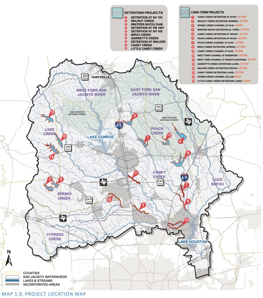
The exec summary also lists the top sixteen project priorities, estimates their costs, outlines possible sources of funding, and lays out next steps.
Project Location Map
Project rankings.Note: Rankings do not necessarily coincide with numbers on map above.
The proposed projects will provide tangible benefits, including reduction in the number of at-risk structures for a range of storms as shown in Figure 1.10 below.
With these projects in place, the level of a 100-year flood at I-69 and the West Fork could be reduced by 5.94 feet, Likewise, where Caney Creek meets the East Fork, the 100-year flood would be reduced by 2.82 feet.
Next Steps
That’s good news indeed for everyone who lives in the San Jacinto Watershed. With this information now in hand, we now can quantify the benefits of projects, priorities them, and get on with the hard work of actual mitigation.
More news to follow.
Posted by Bob Rehak on 12/30/2020
1219 Days since Hurricane Harvey
https://i0.wp.com/reduceflooding.com/wp-content/uploads/2020/12/Screen-Shot-2020-12-30-at-2.06.17-PM.png?fit=1024%2C356&ssl=13561024adminadmin2020-12-30 14:51:422021-01-01 07:17:03Final San Jacinto River Basin Master Drainage Study Released Today, Recommendations Revealed
Two new developments in Montgomery County, Audubon in Magnolia and Country Colony in Porter, will have no detention ponds. The two developments total almost 3,400 acres. During heavy rainfalls, they will dump their floodwater directly into local streams.
The commissioners expressed concern in their 2019 meeting about placing economic hardships on developers. Residents complained about the economic hardships caused by flooding. The developers won.
Theory and Problems with Flood Routing Studies
The idea behind flood routing is simple. If you can show you can get your floodwater to the river faster than a flood’s peak arrives, theoretically, you’re not adding to the peak. Therefore, theoretically, you’re not making flooding worse.
However, engineers and hydrologists point out several flaws with this “beat the peak” theory.
Flood-routing studies don’t consider the cumulative effects of other developments.
They are almost always based on outdated hydrologic models.
They assume “ideal” storm conditions.
“If you start with a brand new hydrologic model,” said one county engineer, “the modeling a developer does could theoretically be accurate. But his/her runoff changes the model. That runoff rarely gets incorporated into the model that the next developer uses.”
And, of course, if everybody rushes floodwater to a river during a flood, that’s the exact opposite of what you want. Holding water back in detention and retention ponds is the best way to reduce flooding.
The two new developments in MoCo exploit this routing-study loophole to avoid the cost of building detention ponds.
Audubon in Magnolia
The first, called Audubon Magnolia will contain 5,000 homes at buildout. It occupies 3,300 acres that drain into Mill Creek, Spring Creek and then the West Fork San Jacinto.
From Audubon’s drainage impact analysis. Note school being placed at edge of floodplain…before new floodplain maps are redrawn based on Atlas-14.
Section 3.1 of the Impact Analysis includes a description of the flood routing study and concludes, “Therefore, the increased flows are able to exit into Mill Creek before the flow from the bulk of the upper drainage basin arrives at the mouth of the stream.”
Correspondence with Montgomery County officials at the front of the document shows their concerns: use of pre-Atlas 14 data; impact on wetlands; building in floodplain; roughness co-efficients used to model speed of water over various terrains; and impact on water surface elevations.
Clearly, the floodplain administrator had major concerns about use of pre-Atlas 14 rainfall data. However, the developer was grandfathered based on the date of the original permit application.
Montgomery County’s new Atlas 14 standards increased the total for a 24-hour, hundred-year rain by 4 inches. The Flood Plain administrator encouraged the developer to model the higher rainfall totals and build to higher elevations. Why? To ensure the likelihood of compliance for those homes in the future.
These documents, dated 2019, are the latest available from Montgomery County. The county engineer’s office indicated that no detention ponds are being planned by the developer or demanded by the County.
Country Colony in Porter
The second development, Country Colony, lies just north of the Harris County/Montgomery County line at the end of West Lake Houston Parkway. Country Colony occupies approximately 80 acres immediately west of the Triple PG sand mine.
Note county line at southern edge of development. Also note how some of the lots are actually in the floodplain of White Oak Creek.Country Colony. Taken December 7, 2020, looking east toward Triple PG Sand Mine in background.
No detention ponds here either! A big heads up to the people downstream in Walden Woods, Woodstream Forest and beyond.
Posted by Bob Rehak on 12/12/2020
1201 Days since Hurricane Harvey
The thoughts expressed in this post represent opinions on matters of public concern and safety. They are protected by the First Amendment of the US Constitution and the Anti-SLAPP Statute of the Great State of Texas.
https://i0.wp.com/reduceflooding.com/wp-content/uploads/2020/12/20201207-Aerial-Dec-2020_446.jpg?fit=1200%2C800&ssl=18001200adminadmin2020-12-12 20:51:402020-12-12 20:53:04Two New MoCo Developments Will Total Almost 3,400 Acres, Have No Detention Ponds
Recently released subsidence maps show that excessive groundwater pumping in Montgomery County could lower the northern end of Lake Houston by two feet or more relative to the spillway at the southern end of the lake. While subsidence would lower the area near the spillway by a foot, it would lower areas near the county line even more – from 3 to 3.25 feet.
Subsidence Estimates are Conservative
And those estimates are conservative because:
Models under-predict subsidence; they currently model nothing from the Jasper Aquifer, which Quadvest, a MoCo water supplier, wants to pump heavily from (see more below).
Montgomery County factions are threatening legal action to let them pump more than their counterparts in the 15-county Groundwater Management Area #14 (GMA14) think is safe.
So how did we get to this point?
Groundwater Vs. Surface Water
The rest of the world is trying to convert to surface water to avoid subsidence. However, Simon Sequeira’s family-owned business, Quadvest, still pumps much groundwater in Montgomery County. He’s at war with the world. While others recognize subsidence and the science behind it, Sequeira denies it’s a problem – at least in Montgomery County.
At the last GMA14 meeting, lawyers were reportedly lining up to get a piece of his action and licking their lips.
Broken Promises And Legal Battles
Several years ago, Sequeira led a fight to get the board of the Lone Star Groundwater Conservation District elected rather than appointed. Then he backed candidates who favored unlimited groundwater pumping and promised to Restore Affordable Water.
While groundwater is cheaper than surface water, water bills reportedly failed to come down. However, he has stopped paying the SJRA a fee designed to encourage conversion from groundwater to surface water. Sequeira says he is setting aside that money in a special fund in case he loses his legal battle. But his legal battles go far beyond the SJRA. He and the board of the Lonestar Groundwater Conservation District are also taking on the rest of GMA14. See map below.
GMA 14 includes the 15 colored counties above. Each color represents a different Conservation District.Montgomery County (dark blue) has the Lonestar Groundwater Conservation District.
Purpose of Groundwater Management Areas
GMA stands for “Groundwater Management Area.” GMAs were set up years ago, in part, to make sure that one county doesn’t hog groundwater, depriving surrounding areas and creating subsidence. So the other counties in GMA14 get to approve (or not) the groundwater withdrawal rates in Montgomery County.
They do that by defining “desired future conditions.” How much drawdown in an aquifer is acceptable? How much subsidence can people and infrastructure tolerate?
GMA14 wants Sequeira to leave 70% of the water in aquifers intact and to produce no more than 1 foot of subsidence. But the pumping levels proposed by Sequeira would produce far more subsidence, according to GMA14.
Hired-Gun Experts Defy Scientific Consensus
Ever since, Sequeira took on this fight, his hired-gun experts have been trying to prove subsidence doesn’t pose a threat in Montgomery County. Unfortunately, data and models don’t agree with him. His pumping has already created subsidence in MoCo and now threatens northern Harris County, too.
Front steps of Woodland’s homeowner Dr. Mark Meinrath in 1992 and 2014. Part of Meinrath’s home straddles a fault which subsidence triggered. Relative to the rest of his house, these front steps dropped 9.9 inches in 22 years.
Strangely enough, while science has shown – and the rest of the world believes – that unlimited groundwater pumping causes subsidence, Sequeira does not. His profit margin depends on cheap groundwater, unfettered by fees designed to encourage people to convert to surface water.
Five Alternative Plans Considered
Sequeira and company originally proposed three alternative plans to GMA14 that involved pumping enough groundwater to cause:
900 feet of decline in the Jasper Aquifer
700 feet of decline in the Jasper Aquifer
250 feet of decline in the Jasper Aquifer (Similar to “Run D” scenario, modeled below.)
Of those three, GMA14 only considered the last. GMA14 also came back with two more scenarios. They involved pumping even less groundwater:
115,000 acre-feet per year (Also similar to Lone Star’s “Run D” scenario. See below).
97,000 acre-feet per year
61,000 acre-feet per year
Note: Lone Star and GMA14 use different criteria to describe the volume pumped. GMA14 uses acre-feet-per-year instead of feet-of-decline in a specific aquifer. Nevertheless, experts say Sequeira’s last scenario is roughly comparable GMA14’s first.
The two sides are still arguing about how much can be pumped safely. And that’s why the lawyers are drooling.
Models Show Unacceptable Subsidence from Sequeira’s Least-Damaging Plan
Subsidence can alter the landscape in ways that cause water to collect in areas that otherwise might not flood. The maps below model projected subsidence in south Montgomery and northern Harris Counties. And we know that this model under-predicts subsidence. That’s because it doesn’t model ANY subsidence from the Jasper aquifer.
Sequeira’s least-damaging plan would cause up to 3.25 feet of subsidence in southern Montgomery County and up to 3 feet in northern Harris County, according to GMA14. See below.
Pumping 115,000 acre feet per year would cause up to 3.25 feet of subsidence in southern MoCo. That’s far more than the 1-foot in the Desired Future Conditions definedby GMA14.The same amount of pumping would cause up 3 feet of subsidence in parts of Kingwood and Huffman, and a foot or more in much of the rest of Harris County.
Effect on Humble, Kingwood, Atascocita, Huffman Areas
If you live in the Lake Houston Area and you stare at that last subsidence map long enough, eventually you will come to a jaw-dropping realization.
The Lake Houston spillway is only subsiding by a foot. But the headwaters of the lake are subsiding up to 3 feet. Imagine filling a bowl with water and then tilting it toward one side.
Homes and businesses in the headwaters of Lake Houston will be lowered2 feet relative to the spillway.
That’s a huge amount. Those who built homes a foot above the hundred year flood-plain could find themselves a foot below it. Those who had a couple inches of water in their homes during Harvey could have more than two feet in a similar future event because of subsidence.
Battle Lines Drawn
So the battle lines are drawn. Sequeira wants to allow up to 900 feet of decline in the Jasper aquifer. And GMA14 wants no more than 1 foot of subsidence with 70% of the aquifer intact. That would mean pumping less than 100,000 acre feet per year.
The presence of so many lawyers in the last GMA14 meeting reportedly has the smaller groundwater management districts nervous. One observer used the word “intimidated.” Some don’t have financial resources to fight Sequeira.
And that should make every homeowner in the Lake Houston Area nervous, too.
Posted by Bob Rehak on 11/22/2020
1181 Days since Hurricane Harvey
The thoughts expressed in this post represent opinions on matters of public policy and safety. They are protected by the First Amendment of the US Constitution and the Anti-SLAPP Statute of the Great State of Texas
https://i0.wp.com/reduceflooding.com/wp-content/uploads/2020/11/Slide2.jpeg?fit=1200%2C675&ssl=16751200adminadmin2020-11-22 15:36:592020-11-23 09:36:15Someone’s Trying To Tilt Lake Houston Toward Your House
Camcorp Management is building a new high-density development in Montgomery County called Brooklyn Trails on a tributary of Ben’s Branch upstream from Kingwood. The development’s detention pond is apparently 30% smaller than new Atlas-14 regulations would require for this area.
Most of Brooklyn Trails is still vacant...…but time is running out to do something. High density homes are going up quickly.
Even though plans were discussed, reviewed and revised after Atlas 14 went into effect, in Montgomery County the submission date determines which rainfall statistics apply.
Ben’s Branch cuts diagonally through Kingwood. It goes through three commercial areas: Northpark, Town Center and Kings Harbor. Bear Branch Elementary, Kingwood High School and the Humble ISD instructional center all border Ben’s Branch, not to mention hundreds of homes and St. Martha Catholic Church.
Rainfall rates that A&S used to design drainage for Brooklyn Trails vary substantially from MoCo’s new rate and Atlas-14 rates for the Lake Houston Area.
Montgomery County bases its 100-year/24-hour rainfall rate on Conroe (the County seat). Despite variations within the county from north to south, adopting the Conroe rate makes it easier for developers to calculate detention requirements. Some parts of the county have no gages. However, the uniform rate also understates the detention needed for new developments in the fast growing southern part of the county, which receives more rain.
Differences Between Three Rates
The three different rates referenced above for the 24-hour 100-year rain break down as follows:
17.3 inches = Rate for 100-year/24-hour rain for Lake Houston Area by NOAA (see below)
That means Brooklyn Trails is 25% short of MoCo’s new requirements and 30% short of NOAA’s.
NOAA Atlas 14 Rainfall Totals for the Lake Houston Area. Brooklyn Trails is 3 miles from Lake Houston but 20 miles from Conroe.
In fact, the rate A&S used (12.17 inches) corresponds to a 10- to 25-year rain by NOAA’s new standards, not a 100-year rain.
A&S Engineers Certify No Adverse Impact
A&S concluded on page 10 of its analysis that “…the proposed excavation/fill will cause no increase to the base flood elevation, and the proposed excavation/fill will have no adverse impact to the drainage on, from, or through adjacent properties.”
That may be true if you base all your calculations on rainfall that’s 30% less than NOAA’s best available statistics. Or even the new MoCo numbers. But, in fact, we get more rain.
Both Montgomery County and City of Houston signed off on the A&S plans. The City signed in January before the Elm Grove floods. Montgomery County signed after the Elm Grove floods – on 10/1/19.
There’s time to fix this before the development is built out. But that window is rapidly closing.
Posted by Bob Rehak on 10/12/2020
1140 Days since Hurricane Harvey and 389 since Imelda
The thoughts expressed in this post represent opinions on matters of public concern and safety. They are protected by the First Amendment of the US Constitution and the Anti-SLAPP Statute of the Great State of Texas.
https://i0.wp.com/reduceflooding.com/wp-content/uploads/2019/10/NOAA-Atlas-14-Rainfall-Rates-for-Kingwood.png?fit=976%2C828&ssl=1828976adminadmin2020-10-12 22:12:262020-10-12 22:49:24MoCo Development on Ben’s Branch Understates Current Detention Pond Requirement by 30%