June 5, 2024 – The Triple PG sand mine trial, originally scheduled for 2020, has been rescheduled yet again for March 2025 – a five year delay and counting.
A new schedule shows the Texas Attorney General lawsuit against the Triple PG sand mine in Porter may go to a jury on March 24, 2025. Originally, the case was set for trial on June 22, 2020.
But a corporate shell game by the defendant created a series of delays while the AG tried to figure out who was on first.
Then they took two years off for COVID. Finally the judge scheduled a conference call to jumpstart the case in 2022.
Original Complaint
The Texas Attorney General (AG) sued the Triple PG sand mine in Porter on behalf of the Texas Commission on Environmental Quality in 2019. Two breaches in the mine’s dikes were allowing industrial wastewater to flush into White Oak and Caney Creeks, then into the headwaters of Lake Houston. The lake supplies drinking water for two million people.
But not much has happened since then. And the Triple PG sand mine trial just got postponed. Again. Without explanation.
New Scheduling Order
See the second amended agreed scheduling order in the Triple PG sand mine trial. Five years of delays on a case originally scheduled to go to trial in one year!
The Attorney General’s office did not respond to a request for explanation or comment.
Discovery is now supposed to end on December 20, 2024. And a jury trial will begin “on or after March 24, 2025.” Uh, oh! I don’t like that “or after” part.
While Everyone Delayed…
Along the way, those daredevils at the Triple PG have:
Those bullet points just scratch the surface. I’ve created more than 60 posts that feature the Triple PG mine.
All Charges Denied
Prabakar Guniganti, the cardiologist from Nacogdoches owns the mine through one of his shell companies. The Montgomery County Appraisal District shows that the Guniganti Children’s Trust Fund owns it now. Guniganti has denied all charges by the TCEQ and Attorney General.
Pipeline that wasn’t exposed, December 6, 2019Wastewaterat Triple PG mine, July 27, 2022.Guniganti has an ag/timber tax exemption on this gem.Trees killed by process wastewater on neighboring property, June 6, 2022Triple PG wastewater flowing unobstructed into Caney Creekand Lake Houston,September 2019
Posted by Bob Rehak on 6/5/24
2472 Days since Hurricane Harvey
The thoughts expressed in this post represent opinions on matters of public concern and safety. They are protected by the First Amendment of the US Constitution and the Anti-SLAPP Statute of the Great State of Texas.
https://i0.wp.com/reduceflooding.com/wp-content/uploads/2024/06/20190927-Helicopter9.27_106.jpg?fit=1100%2C733&ssl=17331100adminadmin2024-06-05 18:22:362024-06-05 18:28:29Triple PG Sand Mine Trial Delays Total 5 Years Now
The controversial new Royal Pines subdivision that flooded a neighbor four times in two months has finally built a stormwater detention basin.
The good news: The basin should capture water flowing from one direction toward the neighbor.
The bad news: The height of the berm around the pond could back up water from the opposite direction onto the neighbor’s property. The concentrated flow could also erode the earth over a natural gas pipeline.
Drainage Now Concentrated Over Pipeline
The pipeline is buried only 36″ deep along the silt fence in the photo below. So any floodwater coming from the west (right) will now be concentrated directly over the pipeline.
Water used to converge from both east and west toward a natural depression in the middle of the new development. But contractors changed the natural grade, confusing the situation.
Looking south from over White Oak Creek toward the new 6.3-acre detention pond in the NW corner of Royal Pines. Water drains toward camera.
The drainage impact analysis for Royal Pines below shows that 11.6 acres outlined in purple (labeled as OFF1, for offsite area #1) drains through the larger 49.5 acre area that contains detention Pond 1 shown in the upper left. The plans show a channel running about a quarter of the way down the left border where the silt fence now is, then mysteriously stopping.
When I first saw the plans, I assumed the water in that channel would empty into the pond. But no inlets are installed at that location. At least not yet even though others are installed elsewhere.) See below and above.
Looking west toward neighborhood that flooded from development. No inletscome from that direction.
Instead, water coming from the west will meet a wall approximately 8 feet high.
The wall of the detention pond. This area used to slope down toward the trees in the background.Now you can barely see them.
The berm forms a dam against any water coming from the west (behind the camera position). That includes floodwaters from White Oak Creek.
So where will the stormwater go? Instead of spreading out, it will be squeezed between the berm and homeowners. That has the potential to cause more flooding.
The analysis claims the development will have no adverse impact either up- or downstream. However, during a five-year rain in January, the level of White Oak Creek came up much higher than a five-year flood.
What’s on the ground counts for more than what’s on paper.
Another Danger Lurks 36″ Down
But there’s potentially an even bigger danger. A natural gas pipeline is buried next to that silt fence that borders homes along the western edge of the detention pond. Erosion from all that concentrated water rushing over the pipeline could expose it, just as it exposed another pipeline 1.5 miles away.
The man behind the mine, Prabhakar Guniganti, also owns or owned Royal Pines. His name shows up on the general plan, although the Montgomery County tax rolls show a company called TC LB Royal Pines LP now owns the property. It’s not clear if there’s a connection between Guniganti and the Royal Pines Limited Partnership.
Guniganti has a history of corporate shell games. After the Attorney General sued him, ownership of his mine changed hands so many times that the AG had to add five shell companies to the lawsuit. The AG also added Guniganti as an individual and as a director of the companies/partnerships to the lawsuit. Because of all the delays, the case still has not gone to trial.
This does not inspire confidence. Especially among homeowners who may be flooded, but don’t have the State’s deep pockets.
When I and homeowners talked to Montgomery County Engineering last week, the developer did not yet have a construction permit for the pond. The county said only that if any changes become necessary, they will be at the developer’s expense.
Just a reminder. Section 11.086 of the Texas Water Code states, “No person may divert … the natural flow of surface waters in this state, or permit a diversion to continue, in a manner that damages the property of another…”
Posted by Bob Rehak on 2/25/2023
2006 Days since Hurricane Harvey
The thoughts expressed in this post represent opinions on matters of public concern and safety. They are protected by the First Amendment of the US Constitution and the Anti-SLAPP Statute of the Great State of Texas.
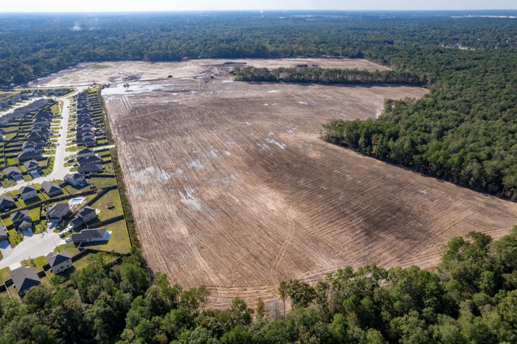
Today, Royal Pines looks vastly different from the way it did last April. If such a thing as “truth in development naming” existed, they would have to call it “The Barrens of Kingwood.”
I first reported on the clearing of 200+ acres for this new development back in April 2022.
Now see the four photos below taken from different angles on 10.31.22.
Looking NE from Porter across the barrens.Looking SE.The only thing taller than tire ruts are some piles of mulch that still need to be hauled away.Looking West from near White Oak Creek. Country Colony on left.Looking West from entrance.
Royal Pines bought the land from the 1992 Guniganti Credit Shelter Trusts on 12/9/21. The Guniganti family owns the Triple PG sand mine east of the area being cleared. You can see it in the background of the first two photos above.
The plan above shows that 80+ homes are in the pre-Atlas-14, 100-year floodplain. Six are in areas LOWER than the 100-year flood plain.
Use of old flood-plain maps could put unsuspecting buyers at risk. The flood plain maps for this area were last updated in 2014. New Atlas 14 maps may not become official for several more years…potentially after this developer starts selling homes.
The thoughts expressed in this post represent opinions on matters of public concern and safety. They are protected by the First Amendment of the US Constitution and the Anti-SLAPP Statute of the Great State of Texas.
https://i0.wp.com/reduceflooding.com/wp-content/uploads/2022/11/20221031-DJI_0079.jpg?fit=1200%2C799&ssl=17991200adminadmin2022-11-02 10:36:292022-11-02 16:58:10From Lush Forest to Pine Barrens in 7 Months
Despite multiple reprimands from the TCEQ and a lawsuit by the Texas Attorney General, the Triple PG mine apparently continues to discharge process wastewater onto neighboring properties. Photos taken on 5/4/22 show those neighboring properties under water despite unusually dry weather and record heat recently. Those same properties were not flooded just days after Tropical Storm Imelda, which dumped more than 25 inches of rain on the area.
Let’s first look at the location of the neighboring properties. Triple PG owns most of the property west of the mine with one notable exception – a strip of 20 properties isolated near the mine’s stockpile. See the map from the Montgomery County Appraisal District below.
Properties in question are inside the red oval.MCAD shows that Guniganti sold the Royal Pines land to TC LB ROYAL PINES LP on 12/9/21.
Dr. Prabhakar R. Guniganti, who owns the mine, didn’t seem to get the message. And pictures taken two days ago suggest he still doesn’t – despite the threat of a million dollar fine.
Compare Before/After Aerial Images
The image below, taken before discharges into this area started, shows the neighboring properties in question. They are the strip of trees between the foreground and background. Note how the land is not flooded, despite the fact that I took this picture just days after Tropical Storm Imelda, which dumped more than 25 inches of rain on this area. Also note the dense forest canopy.
Looking south toward stockpile in background. Properties in the forested strip do not belong to Guniganti. I took this picture on 9/27/2019, ten days after Imelda. Reverse shot looking N from over stockpile. Taken in March 2020. Other shots taken in this series show water on neighbors’ property higher than inside the mine.
Now, fast forward two years. Aerial pictures below taken on 5/4/22 show the same property – under water – despite only 4 inches of rain in the last month!
The new images also show most of the once-lush vegetation has died. All trees on the neighboring property adjacent to the mine are dead with the exception of one small copse on higher ground. And the water is blackish.
Dead trees on property adjoining Triple PG mineimmediately north of the mine’s stockpilein foreground. 5/4/22.Looking NE.The dead trees on neighbor’s property adjoin the mine’s wastewater pit. 5/4/22.
Hmmmm. Let’s see. Not flooded days after 25 inches of rain during Imelda. Flooded after 4 inches in the last month. Once healthy trees now dead. How curious! I wonder how that works. Judging from the healthy trees in the background, I’m guessing the mine’s wastewater may have had something to do with their demise.
Prabhakar R. Guniganti, as Director of Triple P.G. Sand Development, L.L.C.
Prabhakar R. Guniganti, as sole manager of Guniganti Family Property Holdings, L.L.C.
Guniganti Children’s 1999 Trust.
The AG contends that regardless of which legal entity owns the mine, they all lead back to the same man and they all had an obligation to ensure that process wastewater was not discharged into waters of the State.
During the next big rain, at least some of this will flush down White Oak Creek, which joins Caney Creek and the East Fork San Jacinto. Then, it will enter Lake Houston a little more than 2 miles downstream.
Close up cropped from image above.This used to be high, dry and covered with green. Compare with first image at top of post.
Lake Houston supplies drinking water for two million people. I’m not sure what’s in this water. But if it kills trees, it can’t be healthy for humans. It also can’t be healthy for neighboring property values.
Posted by Bob Rehak on 6/7/2021
1743 Days since Hurricane Harvey
The thoughts expressed in this post represent opinions on matters of public concern and safety. They are protected by the First Amendment of the US Constitution and the Anti-SLAPP Statute of the Great State of Texas.
https://i0.wp.com/reduceflooding.com/wp-content/uploads/2022/06/DJI_0641.jpg?fit=2048%2C1364&ssl=113642048adminadmin2022-06-06 15:59:002022-06-06 16:03:29Triple PG Wastewater Apparently Killing Trees on Neighboring Property
Mere days after the Texas Attorney General (AG) filed a lawsuit against Triple P.G. Sand Development, the mine’s owner transferred ownership of the mine. Even though the transfer was recorded in October, the attorney general says the papers were dated for the prior January — before the unauthorized discharges from the mine that triggered the AG’s lawsuit.
Hundreds of Millions of Gallons of Wastewater Discharged
Two unauthorized discharges from the mine in Porter during May and September last year let hundreds of millions of gallons of sediment-laden wastewater escape into the headwaters of Lake Houston, the source of drinking water for 2 million people.
The putative ownership transfer was recorded in October, days after the lawsuit was filed. But it was dated for the prior January—before the May and September discharges that triggered the law suit!
The AG didn’t allege any motives. But the suspicious ownership transfer may have been an attempt to shield assets from prosecutors. People often set up multiple companies, trusts and partnerships to shield assets in one from lawsuits in another.
Prabhakar R. Guniganti, as Director of Triple P.G. Sand Development, L.L.C.
Prabhakar R. Guniganti, as sole manager of Guniganti Family Property Holdings, L.L.C.
Guniganti Children’s 1999 Trust.
TCEQ Surprised by “Different Operator” at Facility
The Attorney General’s amended petition states, “In or around May 2020, prior to expiration of the Temporary Injunction, Texas Commission on Environmental Quality (TCEQ) investigators conducted a site visit and were informed that a different operator had taken over operations at the Facility.”
Ironically, instead of shielding assets (if that’s what he was trying to do), Guniganti exposed more of his family’s holdings. Now they’re all part of the lawsuit.
Guniganti Family Property Holdings, L.L.C. was the recorded property owner at the time of the May and September 2019 breaches. However, new ownership records now show that in October 2019, Guniganti Children’s 1999 Trust owned the property.
Prabhakar R. Guniganti is the sole director of Triple P.G. Sand Development and sole manager of the Guniganti Family Property Holdings. The AG’s amended petition alleges Guniganti orchestrated the ownership transfer as the sole manager of Defendant Guniganti Family Property Holdings.
Officially, the State filed the amended petition to name additional entities that are responsible for the 2019 discharges. They also share a continuing responsibility to prevent discharges in the future by performing corrective actions to improve the site.
Basis for Lawsuit
The TCEQ cited Triple P.G. in both months during 2019 for the unauthorized discharge of millions of gallons of sediment-laden process wastewater. In May, the entire contents of the Triple P.G. dredge pond (about 180 acres in area) were released into Caney Creek. TCEQ estimates 325 million gallons of sediment-laden water exited into Caney Creek, which leads directly to the East Fork of the San Jacinto River and onward to Lake Houston. Then, more breaches occurred in September, 2019.
Triple P.G. agreed to injunctive relief last fall. The injunction required Triple P.G. to cease dredging operations, to repair breaches, and to retain an engineer who would propose a plan to ensure the berms could hydraulically isolate the process waste water from waters of the State. The Court entered the Agreed Temporary Injunction on November 25, 2019.
The AG contends that regardless of which entity owned the mine, they all lead back to the same man and they all had an obligation to ensure that process wastewater was not discharged into waters of the State.
The AG believes all entities are liable for unauthorized discharges pursuant to Texas Water Code 26.121(c), which makes it unlawful to “cause, suffer, allow, or permit the discharge of any waste” in violation of the Texas Water Code.
Dr. Guniganti At Center Allegations
“As the individual with complete management control of sand mining company Triple P.G. and with complete management control of the property on which the Facility is located, Defendant Guniganti had authority to direct activities at the site, including the authority to prohibit or modify sand mining operations on the property, to ensure Triple P.G. maintained adequate berms, and/or to maintain the berms at the Facility to ensure that process wastewater was not discharged into waters of the state,” the AG alleges.
Guniganti, a cardiologist from Nacogdoches who moonlights as a miner, could be fined up to a million dollars for the discharges.
The defendant(s) have until July 20, 2020, to respond to the amended petition.
In other developments in the case, Dr. Guniganti has requested to replace his Austin-based attorney with one from Lufkin.
Posted by Bob Rehak on July 1, 2020
1037 Days after Hurricane Harvey
The thoughts expressed in this post represent opinions on matters of public concern and safety. They are protected by the First Amendment of the US Constitution and the Anti-SLAPP Statute of the Great State of Texas.
https://i0.wp.com/reduceflooding.com/wp-content/uploads/2020/06/20200616-RJR_4335.jpg?fit=1200%2C800&ssl=18001200adminadmin2020-06-30 23:32:522022-05-27 13:08:05Triple P.G. Owner Transferred Ownership of Sand Mine Days After AG Filed Suit
Mysteries at the Triple PG mine in Porter are deepening. In the 19 days before I took the pictures below, we got 0.63 inches of rain at the closest official rain gage (East Fork and FM1485). During that time, the temperature soared into the nineties almost every day and wastewater inside the Triple PG mine got lower. One pond has even almost disappeared. Yet, water outside the mine on neighbors’ properties got even higher. I cannot understand how this works.
Mysteries Defy Logic, Explanation
Dr. Guniganti, the cardiologist from Nacogdoches who owns the mine, must be a genius. He’s managed to construct a parallel universe – in Porter of all places. Porter now rivals Roswell and Area 51 as centers of paranormal activity.
In this parallel universe, Dr. Guniganti can make wastewater magically disappear.
Yet in another display of Dr. Guniganti’s magical prowess and beneficence, the good Doctor makes water fall from clear-blue skies to drench his neighbor’s properties free of charge.
No wonder the community has dubbed him, “Guniganti, the Guy Who’s Got It Going.” At first, I thought neighbors bestowed that phrase on Guniganti for his talent to keep trucks running all night long under the cover of darkness…even as he operated under an injunction by the State’s Attorney General.
The Phlegm of Legend
They used to write ballads about immortals like Guniganti. He’s right up there with Pancho Villa, the Mexican general who inked a deal with a Hollywood studio to film his men in battle for 20% of the gross.
Guniganti’s also going for the gold. He will not be outdone by Pancho Villa, Ray or Egon. I can see the headlines already:
Sandman Takes on Texas
It Ain’t Dumping Unless They Catch You
Man Saved by Covid
The last headline refers to the fact that Guniganti’s case was supposed to go to trial this week. But of course, it didn’t due to the pandemic and some last-minute filings. No telling what those last minute filings are; the Travis County Clerk says it may take up to two weeks to email the documents.
Pictures of the Paranormal
In the meantime, here are more pictures of the paranormal.
Notice how low the water is in Triple PG’s main process wastewater pond (blue/green). The blue/green color is likely due to high chloride levels in the waste water or cyanobacteria.This strip of property adjacent to the mine is owned by other people. Note how high the water is after two weeks of mostly 90 degree days and less than 2/3rds of an inch of rain. It’s a miracle!Compare the height of ponding water on each side of the road. Water is almost overflowing from the neighbor’s property back into the wastewater pond.Water in the next pond over is even lower. It’s almost gone. Guniganti appears to be draining the pond in the foreground so that he can “dry mine.” An injunction has idled his dredge. But how did that water get so low? Where did it go?Can Guniganti make water evaporate in different ponds at different rates?Next to that same pond, by Caney Creek (foreground), a trail of water of various hues leads down from the mine after weeks without rain.
Great Leaping Pond Scum!
Can Guniganti really have the power to make water evaporate from different ponds at different rates? How did water form puddles on the side of that hill? Did water leap out of this mine over the road? Or is Guniganti causing it to flow uphill from Caney Creek using anti-gravity powers?
A former high-level Public Works executive for the City of Houston suggested miners sometimes pump water over the side of their dikes at night.
But I can’t believe an immortal with paranormal powers like Guniganti would need a mechanical assist. Move over Roswell. We need Hollywood to investigate.
Posted by Bob Rehak on 6/27/2020
1033 Days since Hurricane Harveyand 282 since Imelda
The thoughts expressed in this post represent opinions on matters of public concern and safety. They are protected by the First Amendment of the US Constitution and the Anti-SLAPP Statute of the Great State of Texas.
https://i0.wp.com/reduceflooding.com/wp-content/uploads/2020/06/20200616-RJR_4333.jpg?fit=1200%2C800&ssl=18001200adminadmin2020-06-26 22:51:052020-06-27 11:00:12Triple PG Mine Case Extended While Mysteries at Mine Deepen
Of all the sand mines on the East and West Forks of the San Jacinto, the Triple PG Mine is unique. It alone sits inside the confluence of TWO floodways. The Prabhakar Guniganti family owns the mine. So far they have cleared, grubbed and mined about 700 of the 2000 acres they own in the area. But that hasn’t stopped them from receiving timber exemptions from the Montgomery County Appraisal District on the land being mined (that has no timber).
After Harvey, when I found 30 acres of sand up to 15 feet deep covering East End Park (just downstream from the mine), I rented a helicopter to see where the sand came from. That’s when I discovered this horrific mine for the first time.
Last week, Charlie Fahrmeier, a Lake Houston Area resident and an expert in sediment control, observed the same breach open AGAIN. Right above East End Park, which was destroyed by sand AGAIN.
So Friday, I rented another helicopter to see what I could see. What I saw turned my stomach. There was more than one breach. There were at least two and possibly three.
It appeared that Caney Creek (from the north) and White Oak Bayou from the west “captured the pit.” The streams then apparently crossed the mine sweeping out through the breach on the southeast side back into Caney Creek and then down the East Fork of the San Jacinto River.
White Oak Creek approaches the mine from the west and Caney Creek runs along its north and east sides. From the images below, taken a week after Imelda, it appears that the both creeks captured the mine and cut across it.From FEMA’s National Flood Hazard Layer Viewer.
Where Breaches Occurred
The TCEQ fined Triple PG $16,875 for breaches one and two that were first reported after the May 7th storm. TCEQ has opened another investigation into the most recent breaches. Fines could be more substantial this time.
Three Breaches from the Air
Looking north from over the pit toward Caney Creek out of frame on the top. Water likely entered the mine from the north as Caney Creek reached flood stage and cut across the point bar above the mine. Taken 9/27/19.
A reverse shot shows how water tore through the mine.
Looking south from over Caney Creek, you can see how current ripped through the mine. The road across the mine in the middle of the frame had been recently repaired when I took this shot on 9/27/19.At the far end of the shot above on the west (right) side of the mine, I found this breach near White Oak Creek.Taken 9/27/19.Looking east, directly across the mine, I saw this breach in the same location as the May breach. That’s Caney Creek in the background.Taken 9/27/19.This close up shot of the same breach looking west from over Caney Creek shows how flimsy the repair was from earlier in the year. It was nothing but some sand dumped into a hole.Taken 9/27/19.
Designed to Fail?
Two engineers told me that patch looked like it was “designed to fail.” Mine Safety and Health Administration regulation §56.20010 regarding retaining dams specifies that “If failure of a water or silt retaining dam will create a hazard, it shall be of substantial construction and inspected at regular intervals.” Clearly, sand is not substantial. “Built properly, that repair would not have reopened in this past flood,” said Fahrmeier.
TCEQ Requirements for Dike Construction and Repairs
Here are the TCEQ requirements for constructing dikes and levees. Note the paragraph on page 2 about structural integrity. “Construction must be based upon sound engineering principles. Structural integrity must withstand any waters which the levee or other improvement is intended to restrain or carry, considering all topographic features, including existing levees.”
These dikes had the structural integrity of a sand castle at a beach when the tide comes in.
Also interesting: Paragraph 4, Rights of Third Parties to be Protected. It’s a good read as far as regulations go.
Certainly, East End Park, just downstream was not protected.
KSA just finished cleaning up East End Park from Harvey. The organization spent close to $200,000 to restore trails covered in sand that reached to the treetops. Now the entire Kingwood community will have to sacrifice again. This area used to be a boardwalk over wetlands. The sign used to be shoulder high. Now it’s knee high.
Another trail covered in sand and silt. Not all of this came from the mine; some came from river erosion. But the serious problems first appeared after the mine.
How to Tell Mine from River Sedimentation
Charlie Fahrmeier who first discovered the most recent breach said that when he discovered it, water and sediment was streaming out of the mine. The water color was distinctly different from the color of water coming down Caney Creek. If the creek were responsible for all the sedimentation, the colors would have been reversed.
Caney Creek Now Averages 1.7 Feet Deep
In a future post, I will examine the growing mouth bar on the East Fork. That’s right. The East Fork and Caney Creek are barely navigable now. John Alberson took his jet boat up Caney Creek today and noted giant sand bars stretching across the river below the pit. He said the deepest part of the creek was 1.7 feet. The more sand there is in the creek and East Fork, the less room there is for water, so the higher the water rises during a flood.
How to File a Complaint With Mine Safety Authorities
Mine is in two zip codes but breaches appear to be in 77365.
Location of Breach #1: Long 30.102968°, Lat -95.171932°
Location of Breach #2: Long 30.055360°, Lat -95.104712°
Location of Breach #3: 30.065451°, Lat -95.102904°
Please help shut this mine down. It’s dumping its process water loaded with sediment and chlorides into your drinking water. Moreover, the City doesn’t have enough money to dredge the East Fork and its tributaries every time we get a big rain. Let’s stop this problem at the source. We need sand for concrete, but we don’t need it from this mine.
Posted by Bob Rehak on 9/29/2019
761 Days since Hurricane Harvey
The thoughts expressed in the post represent my opinions on matters of public interest and safety. They are protected by the First Amendment of the US constitution and the Anti-SLAPP statute of the great State of Texas.
https://i0.wp.com/reduceflooding.com/wp-content/uploads/2019/09/TripePBreach.jpg?fit=1500%2C1000&ssl=110001500adminadmin2019-09-29 01:04:202019-09-29 08:44:35Triple PG Mine Dikes Breach in Multiple Places, Contributing to Giant East Fork Sand Buildups
On May 18, Josh Alberson and I gave Tony Buzbee a tour of sediment and sand mining issues on the San Jacinto River. Buzbee is a candidate for Mayor of Houston and got to witness first hand some of the problems I have been talking about for almost two years now. On Caney Creek, we stumbled across a giant breach in the dike of the Triple-PG mine in Porter. We reported it immediately to the TCEQ.
Massive breach in dike between Triple PG Mine and Caney Creek, May, 2019
Two-Week Discharge
Investigators actually observed the unauthorized discharge of process water from the mine into the City’s drinking water supply. It continued for approximately two weeks.
Not One, But Two Massive Breaches
The TCEQ found not one, but two breaches. The first was on the southwest side of the mine. Water entered the mine from a breach of the dike near White Oak Creek. The water then swept through the mine and exited through a second breach on Caney Creek. That meant the two creeks were actually flushing process water out of the mine into the drinking water supply for two million people.
The TCEQ finished its investigation in July and cited the operation for failing to prevent the unauthorized discharge of process water. The TCEQ told them to repair and widen their dikes. They did. Case closed.
This same mine has been investigated five times in five years by the TCEQ for various problems detailed in this report. The mine is owned by a cardiologist from Nacogdoches named Guniganti. His family operates it.
The basic problem with this mine is its location. It sits at the confluence of two floodways. That’s why the dikes were blown out. That’s why Harvey’s floodwaters swept through it. Continuing to operate this mine is like flying a plane into conditions that you know are unsafe.
No Disincentive for Dangerous Business Practices
Yet there’s no disincentive for dangerous business practices. Investigators told the operators to fix the breaches. They did. Business will go on as usual. Until the next disaster.
As a society, why do we tolerate this?
We even seem to venerate it. How strange that one family’s profit outweighs the health and safety of millions! The legislature had an opportunity to fix this problem this year. However, one bill that would have established best practices for sand mining and another that would have established minimum setbacks from rivers for sand mines never made it out of committee. Likewise HB-908 proposed by State Representative Dan Huberty that would have provided meaningful financial penalties for such bad practices never made it out of committee.
The thoughts expressed in this post represent my opinions on matters of public interest and safety. They are protected by the First Amendment of the US Constitution and the Anti-SLAPP statute of the great State of Texas.
https://i0.wp.com/reduceflooding.com/wp-content/uploads/2019/05/Mine-Breech.jpg?fit=1500%2C1000&ssl=110001500adminadmin2019-08-23 00:01:462019-08-23 00:19:45TCEQ Observes Triple-PG Sand Mine Discharging Wastewater Directly into Tributary of Lake Houston