Tag Archive for: east fork

Nailed: Triple-P Sand Mine Photographed Discharging Wastewater Directly into Lake Houston Tributary

Since Harvey, I’ve been talking about the dangers of sand mining too close to the river. Texas is the only state I can find that has no minimum setback for mines. Tony Buzbee, candidate for Mayor of Houston, asked to see what I was talking about. So a friend, Josh Alberson, took us on out his jet boat this afternoon.

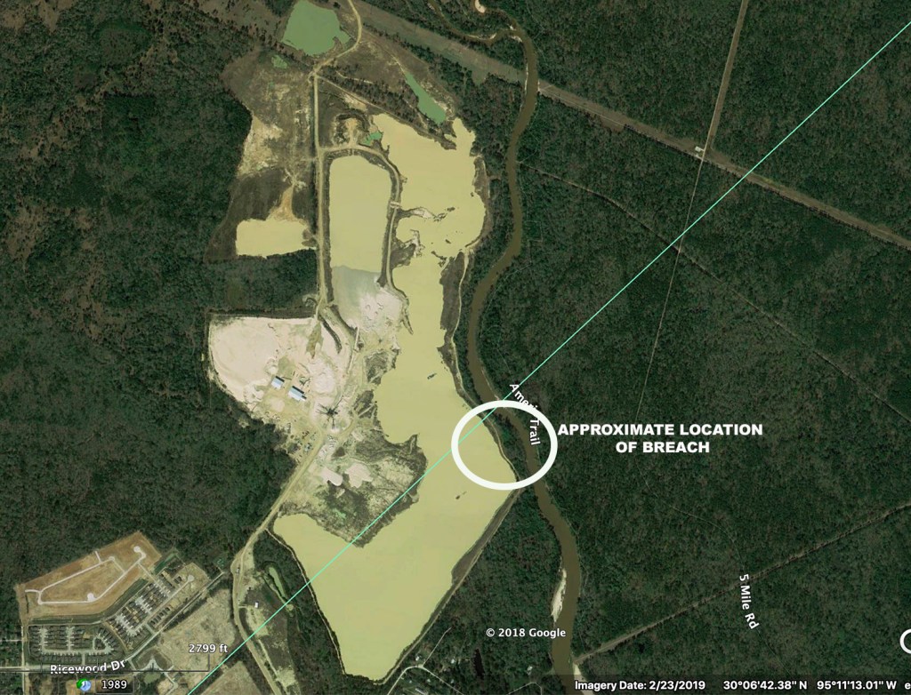
Massive Breach in Mine Dike

As luck would have it, we went up Caney Creek. Just above where it enters the East Fork, we spotted a massive new breach in the dike of the Triple-P mine. Here’s what we saw.

Looking into the Triple-P Mine through a breach in its dike on Caney Creek
Note the exposed shoreline in the background indicating how much water the mine lost to the river.
Looking 180 degrees from the shots above. The tree leaning over at a ten degree angle from the river is on the far bank of Caney Creek.
This shows how wide the breach is in relation to the boat. The boat is 22 feet long.
This shot taken from the boat shows the mine’s cleaning, sorting and transportation equipment in the background. I could not see the dredge operating in the mine’s pit from this angle.
This Google Earth image shows the approximate location of the breach. The blue diagonal line is the Harris/Montgomery County Line. Caney Creek connects up with Lake Houston to the south (bottom part) of this image. Mmmmmmm. That water looks delicious, doesn’t it. If you get your water from Lake Houston, you’re drinking it!
Tony Buzbee, examining the sand bar at the bottom of the shot above (below the mine). The bar has grown in size, according to Alberson, a regular East Fork boater. This illustrates the danger of sand mining so close to the river. Buzbee also visited the mouth bar on the West Fork during his river tour today.

Mine Has History of Problems

I previously posted about breaches in this mine’s dikes and the loss of a major portion of its stockpile during Harvey. The stockpile is located in the confluence of two floodways (Caney Creek and White Oak Creek). Partially as a result of this mine, Kingwood’s East End Park just downstream was inundated with sand and gravel up to 15 feet deep after Harvey. Repairing damage to the trails in the park cost Kingwood residents almost $200,000. The wetlands have been lost forever.

Wetlands no more. Eagle Point in East End Park is drowned in sand from the Triple-P mine. It washed downstream during Harvey. Massive sediment deposits in the San Jacinto have also been linked to flooding by the Army Corps of Engineers.

The Triple-P mine also receives very favorable treatment from the Montgomery County appraisal district. They tax most of it as though it were timberland.

Buzbee as Witness

If you are a sand miner, having Tony Buzbee witness this breach and the massive sedimentation it caused downstream is a nightmare scenario. Not only is Buzbee running for Mayor of Houston, he’s self-funding his campaign. That means he does not depend on TACA contributions. And worse (or better if you are a resident), he’s one of the top litigators in the world. In 2015, he was named Texas lawyer of the year. Kingwood residents can only hope he takes up this cause.

TCEQ Already Investigating

Upon returning home from the boat trip, I immediately notified Ramiro Garcia, head of Compliance and Enforcement for the TCEQ (Texas Commission on Environmental Quality) about the breach in the dike. Garcia says they have people already on the case. I hope they choose to yank this mine’s license and make it an example. At a minimum, I believe they should give the mine the maximum fine. My understanding is that the fine can run up to $25,000 per day. This kind of flagrant violation endangers the health of millions of people and deserves no less.

A water quality expert I talked to about breaches like this told me they spike chloride levels in Lake Houston. Chlorides, you may remember, caused the pipe corrosion in Flint, Michigan, that contributed to pipe corrosion, lead poisoning, a public health crisis and an erosion of trust in local government.

Revive Best Practices Legislation for Sand Mines

As a result of the problems created by sand mining in the San Jacinto River watershed, State Representative Dan Huberty sponsored a bill this year to establish best practices for the mines. HB 909 was referred to the Environmental Regulation Committee on 2/25. The committee heard testimony on 5/1. TACA testified AGAINST establishing and publishing best practices. HB909 has been bottled up in committee ever since.

Please use this breach to try to get the legislation out of committee. This is major. It affects the drinking water supply for 2 million people. I talked about the dangers of mining too close to rivers when I testified for HB909. These miners just don’t care. They think that their ability to make a profit is more important that your health. Please send a message to Austin. Refer the members of the Environmental Regulation Committee to this post and tell them this is what Rehak testified about on 5/1. Have them vote it out of committee. Let’s establish best practices for sand mining in Texas. While we still can.

Here are the members of the Environmental Regulation Committee.

  • J.M. Lozano (Chairman) (512) 463-0463
  • Ed Thompson (Vice Chair) (512) 463-0707
  • Cesar Blanco (512) 463-0622
  • Kyle Kacal (512) 463-0412
  • John Kuempel (512) 463-0602
  • Geanie Morrison (512) 463-0456
  • Ron Reynolds (512) 463-0494
  • John Turner (512) 463-0576
  • Erin Zwiener (512) 463-0647

Please call their office and ask them to vote HB 909 out of committee. Tell them this breach is the great example of why we need this bill. Breaches like this happen far too often. There are only ten days left in this session.

Posted by Bob Rehak on 5/18/19, with a big thank you to Josh Alberson and Tony Buzbee

627 Days since Hurricane Harvey

All thoughts expressed in this post represent my opinions on matters of public policy and are protected by the First Amendment of the US Constitution and the Anti-SLAPP statute of the Great State of Texas.

East and West Forks Out of Banks Already, Flash Flood Watch Extended to 2 a.m. Wednesday

My friend, John Knoerzer, owner of Uniserve Air Conditioning, sent me this video from East End Park around sunset tonight. It shows the East Fork of the San Jacinto River has already come out of its banks. This was at about 6:22 p.m. Tuesday.

Even Gus the Poodle knows to stay away from the raging East Fork. Shown here: the North Loop Trail in East End Park.

I have no pictures from the West Fork, so this graph will have to do. It shows that the West Fork at US59 is already out of its banks and in the moderate flooding stage.

Flash Flood Watch Extended to 2AM Wednesday

Meanwhile, the National Weather Service has extended the Flash Flood Watch for Houston until 2 a.m. Wednesday.  This means conditions are favorable for flooding to occur. A nearly stationary weak boundary is focusing training showers and thunderstorms across the watch area. Very heavy rainfall is occurring in a short time period, which can cause flooding of streets, creeks and bayous. With the loss of daytime heating, precipitation should begin to gradually weaken as we head into the overnight hours. 

Said Jeff Lindner of Harris County Flood Control, “Rainfall amounts of 5-9 inches occurred this afternoon over NE Harris County in the Kingwood/Humble area resulting in significant street flooding. Water is taking time to go down due to the large volume of water that fell in such a short period of time.”

Areas under flash flood watch as of 8:30PM Tuesday night.

Romerica Land Going Under for 7th Time in 14 Months

Harris County’s Real Time Inundation Mapping System shows that the area below the Barrington where Romerica hopes to build it’s residential, commercial and hotel high rises is largely under water as of this writing. That will make the seventh flood in the last 14 months. At times like these, I wish people, i.e., developers with dreams, would learn to listen to nature.

Take Protective Action

Be Prepared.  People should bring their pets inside and delay travel or outdoor activities during periods of heavy rainfall.  If travel is unavoidable, reduce your speed to avoid hydroplaning.  If a Flash Flood Warning is issued for your area, DO NOT travel.  

Turn Around, Don’t Drown®:  Do not drive through flooded areas.  If you see water covering the road, do not attempt to cross it.  Only a few inches of water can float a vehicle . If you find yourself in a dangerous situation where your vehicle is taking on water, get out of the vehicle, get to a higher position, and call 911.   

Monitor Official Sources for Current Information:  Harris County Flood Warning System (harriscountyfws.org), Houston TranStar (houstontranstar.org), and the National Weather Service Houston/Galveston Forecast Office (weather.gov/hgx).

Monitor Stream, Bayou, and Creek Conditions:  Rain may move repeatedly across the same area, causing creeks and bayous to rise and possibly exceed their banks.  Stay informed of current conditions and avoid traveling near creeks and bayous.

Avoid Traveling during Periods of Heavy Rain:  Rain can reduce visibility and prevent you from seeing the road ahead, which could lead to accidents.

Posted by Bob Rehak on 5/7/19 at 8:30 PM

616 Days since Hurricane Harvey

Moderate Flooding Expected on West Fork, Minor Flooding on East Fork

The rain overnight became pretty intense between 4:30 and 5:30 a.m. about the time the NWS issued a tornado watch. Once again, areas north and northwest of us received more rain that we did. The NWS has issued a flood warnings for the West Fork of the San Jacinto. West Fork. They expect the river to crest at 51.3 feet, well below the major classification.

The River should rise above flood stage Friday morning and crest on Sunday. The flood will impact low lying roads near the river. The north side turnaround at US 59 and low points on Thelma Rd, Aqua Vista Dr, and Riverview Dr. will begin to flood. Water levels should approximate those reached in the December 7-8, 2018 event. Nearly all of the water heading into the West Fork is from significant run-off being generated on Cypress, Spring, and Lake Creeks.

The City did not lower Lake Houston in anticipation of this flood. However, the Coastal Water Authority is currently releasing 2500 cubic feet per second through the tainter gates on Lake Houston. It will be interesting to compare the ultimate water height to the Dec. 7-8 flood when the City did lower the Lake.

Here’s what the dock at River Grove looked like this morning. Photo courtesy of Bruce Casto.

Boat dock at River Grove around 9 a.m. on Thursday 12/27/18.

On December 8, River Grove looked like this.

River Grove Flood Level on December 8. Will this flood be higher?


East Fork Crest Delayed and Prolonged

East Fork residents can breath a little easier.

River is already rising at FM 1485 and nearing bankfull at FM 2090 (Plum Grove). Heavy rainfall over the headwaters of the river will move downstream from the Cleveland area and reach Plum Grove and FM 1485 this weekend. The river should rise to flood stage midday Friday and have an extended flat crest over the weekend near 60.5 ft. FM 1485 may be threatened at these levels along with low lying roads in subdivisions downstream of FM 1485. That’s Huffman and Kingwood!

Spring Creek

Significant run-off is in progress over the upper headwaters of Spring Creek and the creek is rising along the entire channel. Hegar Rd is at bankfull this morning and near bankfull conditions will be possible along the creek downstream to SH 249 and I-45. No structure flooding is expected, but some low lying roads near the creek or that cross the creek may be impacted…especially upstream of SH 249.

Cypress Creek

Significant run-off in the headwaters into Cypress Creek. Creek may reach near flood stage later today at Katy Hockley. Harris County Flood Control does not expect any significant downstream flooding east of Hwy 290 along Cypress Creek, although the creek will be very high as upstream water moves downstream.

Posted on 12/27/18 by Bob Rehak

485 Days since Hurricane Harvey

Getting Close to Nature. Maybe too close!

During this recent flood, the East Fork crested after the West Fork – because of where heavy rain fell upstream. This morning, ABC13 posted a story about how FM1485 in New Caney was under water from East Fork flooding.

Otter Point in East End Park at dusk. This deck is normally about 4 feet above lake level. Photo by John Knoerzer.

Tonight, a friend, John Knoerzer, texted this photo to me from Otter Point at East End Park. In case you didn’t know, East End Park is on the East Fork of the San Jacinto. John runs a heating and air conditioning company called UniServe. He’s a great AC guy, but never claimed to be a photographer. Nevertheless, the composition of his photo above almost feels like art.

People familiar with this site will recognize that despite releasing water for days, water is still 4 feet above the normal level and that the East Fork was on the verge of coming out of its banks in the Kingwood area. In fact, it did in some low lying areas.

Once again, I am reminded how very different this flood could have been for many people if the City had not lowered the lake for several days before the rain came. They not only lowered it the announced 18″, they kept lowering it as the flood built. Despite all that, it was a close call.

Close Call Underscores Need for Additional Gates

The frantic efforts to lower the lake underscore how important additional gates are for the Lake Houston Dam. The City needs the ability to shed water faster before it reaches the height of the spillway. With greater capacity, operators can reduce uncertainty associated with pre-releasing water…by waiting until storms are closer and forecasts become more certain. Operators can then be confident that they are not wasting precious water.

Weather forecasts can be notoriously fickle. And in fact, this one did not drop rain where predicted. Nor did it drop as much as predicted. Still, many areas were on the verge of being submerged as you can see from the photos above and below.

Parks are meant to be flooded. Fuel tanks? Not so much.

Kudos for Houston City Council Member Dave Martin for leading the charge in the effort to get the City to pre-release water.

U.S. Army Corps of Engineers’ command post for emergency dredging almost had an emergency of its own. Another foot higher and the site would have flooded. Photo taken Saturday afternoon, the day after the heavy rain.

Posted by Bob Rehak on 12/11/2018

469 Days after Hurricane Harvey

San Jacinto River at Its Finest: Nature the Way It Was Meant to Be

Today, I took a much needed rest from floods, sand mines, sedimentation and tax appraisals. A friend took me and two others out on his boat for a day long encounter with nature. We explored the West Fork, East Fork, Taylor Gulley, Caney Creek, Peach Creek and Luce Bayou. It was a cool, overcast day…the kind that’s perfect for nature photography. Diffused light. Saturated colors. Quiet moments. An intense feeling of beauty and oneness with nature.  Restful and rejuvenating. It taught me that there are still places on the San Jacinto that haven’t been screwed up yet. Places worth fighting for. Today reminded me of something Ansel Adams once said, “If you want to preserve nature, inspire people with its beauty.” Here’s my humble attempt. I hope you enjoy these moments as much as I did. Most were taken far up the East Fork.

Posted on 9/29/2018 by Bob Rehak with grateful thanks to Josh Alberson, his boat, and the Creator.

396 Days since Hurricane Harvey

Five inches of rain helped create the third largest flood in 16 years and sand downstream made it worse

Note: We modified this post to reflect feedback from Harris County Flood Control District and the San Jacinto River Authority. HCFCD provided new information showing rainfall totals far upstream. Confusion over the main point of this article also led us to clarify that rain was a contributing factor to the flood, but not the sole cause. 

The flood on the East Fork of the San Jacinto last weekend (3/31/2018) crested at 66.1 ft. in New Caney.  This was the 10th highest historical crest in the last 35 years – after a relatively minor rainfall event – 4.33 inches as measured on Caney Creek at 2090. That’s the only rain gage operated by the San Jacinto River Authority on the East Fork. Last weekend’s flood was also the third highest in the last 16 years on the East Fork. In fairness, it rained more upstream than at the gauge. HCFCD provided this rainfall map  to show the distribution and said that rainfall averaged five inches across the watershed.

The East Fork: The Forgotten Flooding Problem

With the bulk of Kingwood’s and Humble’s population living on the West Fork of the San Jacinto River, it’s easy to forget that we have a flooding problem on the East Fork as well. The “East Fork” also includes Peach Creek and Caney Creek watersheds as well as Luce Bayou. And there is no shortage of sand coming down the East Fork from the sand mine on Caney Creek. This sand exacerbates flooding problems in the Kingwood and Huffman areas.

Where Did All The Sand Come From?

The sand mine on Caney Creek in Porter upstream of Kingwood comprises approximately 600 acres. The area where they stockpile sand for shipment comprises approximately 34 acres. The image below, taken on 9/14/17 shows how high the sand stockpile is relative to the height of surrounding trees.

Sand mine in Porter in Montgomery County next to Caney Creek. Water tower in background is at Kingwood Drive and High Valley. The mine is just upstream from East End Park in Kingwood where approximately 30 acres were covered with dunes up to ten feet tall after Harvey.

The next image shows what happened to this stockpile during Harvey. At the top right, you can see how torrential rains eroded the pile. They washed sand down to the bottom left where floodwaters carried it downstream. Note the erosion patterns in the flat area to the left (closest to Caney Creek).

Sand mine in Porter in Montgomery County next to Caney Creek shows signs of massive erosion after Hurricane Harvey. Picture taken on 9/14/18.

Just downstream from this sand mine, one can see sand in the tree tops. It appeared there suddenly after Harvey. The sand in the trees reaches an estimated 20 feet. The giant new sand dune in the river reaches an estimated 15 feet.

Confluence of the east fork of the San Jacinto (background) with Peach and Caney Creeks (foreground). Notice sand deposited by Hurricane Harvey stretching into the tree tops and blocking half the river.

Approximately 30 acres of East End Park, in the background to the right, also flooded with sand. At Eagle Point in the Park, sand dunes exceeded 10 feet and covered approximately a half mile of trails with sand that reached shoulder height at times.

Harvey washed sand downstream from mines in Porter in Montgomery County. After the storm, new dunes up to ten feet high covered 30 acres of Kingwood’s East End Park on the East fork of the San Jacinto River and obliterated trails like this one.

Historical Satellite Images Show Increase in Sand Volume

Some people ask, “Could the sand have come from the creek itself?” Fair question. These historical satellite images help answer it. The first satellite image of this area dates to 4/28/2014. At that point, the mine largely constrained the sand within its perimeter. You see only several small white dunes between it and East End Park, outlined in red.

In January of 2017 before Harvey, Caney Creek (see below) still contained relatively little sand. So far, so good.

After Harvey, in October, 2017, we see a radical change in the volume of sand downstream from the mine. Images taken from the helicopter and from the ground (far above) show the depth of these sand dunes. They appeared immediately after Harvey. In real life, the little white streaks in the creek stretch hundreds of feet and reach tree top height. Moreover, both ground level and helicopter photos show that much sand was hidden from satellite view by the tree canopy.

Effect of Siltation on Caney Creek and East Fork

One question remains – the most important one! How has all this sand affected the flow of Caney Creek and the East Fork? The answer: much like the sand on the West Fork has.

Smaller rains have produced bigger floods because the carrying capacity of the river has been reduced.

How You Can Help

Please contact all Harris County commissioners and the county judge. Their email addresses are on the Links page. Ask them to make sure they have enough money in the upcoming bond election to dredge BOTH the East and West Forks of the San Jacinto. Currently, they are only contemplating dredging the West Fork between US59 and West Lake Houston Parkway.

Bill Fowler, co-chair of the Kingwood Grass-Roots Flood Initiative found these statistics. Our thanks to Bill.

Posted on 4/3/18, 217 days since Hurricane Harvey.

Revised 4/10/18, 224 days since Hurricane Harvey.