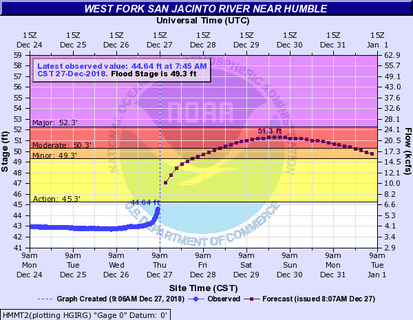
Moderate Flooding Expected on West Fork, Minor Flooding on East Fork
The rain overnight became pretty intense between 4:30 and 5:30 a.m. about the time the NWS issued a tornado watch. Once again, areas north and northwest of us received more rain that we did. The NWS has issued a flood warnings for the West Fork of the San Jacinto. West Fork. They expect the river to crest at 51.3 feet, well below the major classification.

The River should rise above flood stage Friday morning and crest on Sunday. The flood will impact low lying roads near the river. The north side turnaround at US 59 and low points on Thelma Rd, Aqua Vista Dr, and Riverview Dr. will begin to flood. Water levels should approximate those reached in the December 7-8, 2018 event. Nearly all of the water heading into the West Fork is from significant run-off being generated on Cypress, Spring, and Lake Creeks.
The City did not lower Lake Houston in anticipation of this flood. However, the Coastal Water Authority is currently releasing 2500 cubic feet per second through the tainter gates on Lake Houston. It will be interesting to compare the ultimate water height to the Dec. 7-8 flood when the City did lower the Lake.
Here’s what the dock at River Grove looked like this morning. Photo courtesy of Bruce Casto.

On December 8, River Grove looked like this.

East Fork Crest Delayed and Prolonged
East Fork residents can breath a little easier.

River is already rising at FM 1485 and nearing bankfull at FM 2090 (Plum Grove). Heavy rainfall over the headwaters of the river will move downstream from the Cleveland area and reach Plum Grove and FM 1485 this weekend. The river should rise to flood stage midday Friday and have an extended flat crest over the weekend near 60.5 ft. FM 1485 may be threatened at these levels along with low lying roads in subdivisions downstream of FM 1485. That’s Huffman and Kingwood!
Spring Creek
Significant run-off is in progress over the upper headwaters of Spring Creek and the creek is rising along the entire channel. Hegar Rd is at bankfull this morning and near bankfull conditions will be possible along the creek downstream to SH 249 and I-45. No structure flooding is expected, but some low lying roads near the creek or that cross the creek may be impacted…especially upstream of SH 249.
Cypress Creek
Significant run-off in the headwaters into Cypress Creek. Creek may reach near flood stage later today at Katy Hockley. Harris County Flood Control does not expect any significant downstream flooding east of Hwy 290 along Cypress Creek, although the creek will be very high as upstream water moves downstream.
Posted on 12/27/18 by Bob Rehak
485 Days since Hurricane Harvey


