Tag Archive for: east fork

Floodwaters Converging Downstream on Lake Houston

As of Monday morning, the threat to Lake Conroe had passed, but now floodwaters from the rain soaked northwestern portion of the region are converging on Lake Houston. Here’s a roundup of what’s happening where.

Lake Conroe Going Down

The San Jacinto River Authority reduced its discharge rate to from 9275 cubic feet per second (CFS) to 8120 CFS as the level of Lake Conroe continued to recede, but the West Fork came out of its banks at US 59. The West Fork also began flooding Kingwood’s River Grove Park and the abandoned Noxxe Oil Fields between the river and the Forest Cove Little League Fields.

As of 5:09 pm on 5/3/2021

Lake Conroe Re-Opening With Caution

The SJRA issued a press release at 10:15 am. stating that Lake Conroe will reopen to normal lake traffic at noon Monday, May 3. However, boaters are still urged to use extreme caution due to floating debris and submerged objects that may not be fully visible. With submerged bulkheads, lake area residents should also be cautious of electrical outlets and equipment coming into contact with water.

SJRA is currently releasing water from the Lake Conroe dam to gradually lower the water level back to conservation pool of 201’, but SJRA must strike a balance between upstream recovery and downstream danger. For real-time information on Lake Conroe levels, releases, rainfall totals, or stream flows visit www.sjra.net

SJRA clarified that it intends to return Lake Conroe to 200 until June 1 per its seasonal lake lowering policy as soon as emergency operations restore it to 201. Normally, SJRA would begin recapture on June 1, not May 1. The seasonal release rate is much lower than the current rate.

Floodwaters Converging Toward South and East

Meanwhile, the glut of rainfall that inundated the northwest portions of Houston last week is starting to converging on areas downstream.

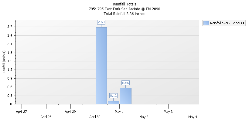
As of 10:30 am, the San Jacinto East Fork is also way out of its banks at FM1485 and FM1485 is reportedly closed until Friday. That leaves one way in and out of Colony Ridge – FM2090.

The San Jacinto East Fork at FM2090 peaked overnight and is starting to recede, but is still out of its banks. The East Fork is not influenced by the Lake Conroe Dam, which is on the West Fork.

FM2090 at East Fork near Plum Grove on May 3, 2021 at noon.

FM2090 is still open, but Plum Grove resident Michael Shrader reported a steady line of traffic trying to get out of Colony Ridge up to 11:30 PM Sunday night. This underscores the need to develop alternate evacuation routes for the fast growing subdivision.

Meanwhile, the flood threat is receding at Peach Creek and FM2090.

Caney Creek at FM2090 is getting back within its banks.

And the West Fork, however, is still rising. By 9 a.m. (six hours after the hydrograph below) it was out of its banks at US59.

Flood Warning Remains in Effect for West Fork Until Further Notice

At 2:45 PM CDT Monday, the National Weather Service indicated the West Fork was 49.6 feet.

  • Flood stage is 49.3 feet.
  • Minor flooding is occurring and minor flooding is forecast.
  • Forecast…The river is expected to rise to a crest of 49.7 feet late this afternoon. It will then fall below flood stage late Wednesday morning.
  • Impact…At 49.3 feet, Minor lowland flooding begins in the vicinity of the gage. North side turnaround at US 59 begins to flood. Low points on Thelma Road, Aqua Vista Drive, and Riverview Drive begin to flood.
  • Flood History…This crest compares to a previous crest of 49.7 feet on 11/13/2008.

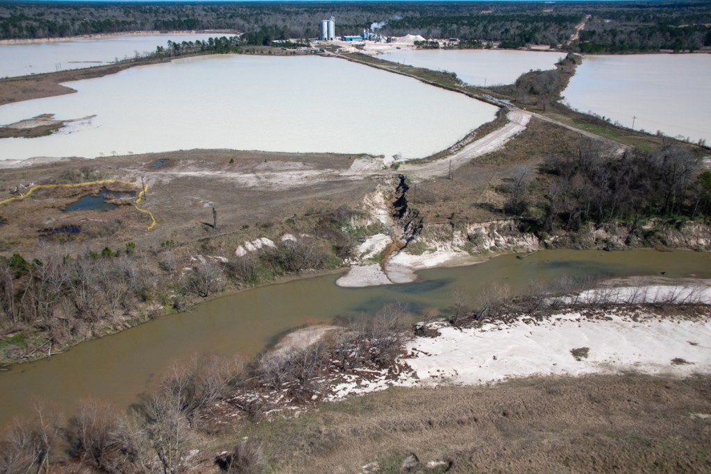
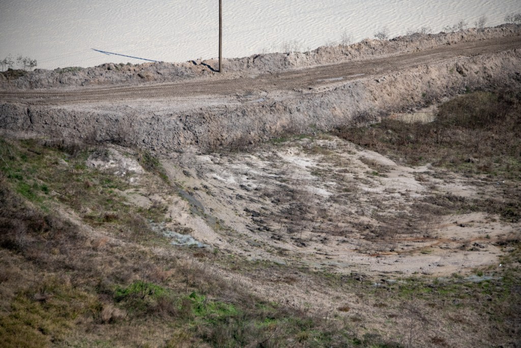
Here are photos taken along the West Fork this morning.

A young couple surveys rising floodwaters at the turnaround under the US59 bridge. The river bank is about a hundred yards in front of them at the sign in the background. This is the northwestern extent of Lake Houston.
A log jam forms from flood debris under the pedestrian bridge over the West Fork.
Floodwater had crept past the edge of Harris County’s Edgewater Park.
However traffic was still flowing on US59 in both directions.
About a third of the abandoned Noxxe Oil Field by the Forest Cove Little League fields was under water.
The soccer fields at River Grove were partially submerged. Yesterday they were mostly dry.
The boardwalk at River Grove was underwater except for the entrance.
There was no immediate threat to Kings Harbor though the dock was only inches above water.
As floodwaters work their way downstream, Lake Houston continues to rise. As of 5:30PM on 5/3, the lake is now up more than 1.6 feet and many docks are starting to go under.

No widespread flooding is expected in the Lake Houston Area. But people who live in low-lying areas or near the lake should take precautions.

Posted by Bob Rehak on 5/3/2021 based on information from NWS, HCFCD, Jeff Lindner, SJRA, Michael Shrader and personal observation

1343 Days since Hurricane Harvey and 592 since Imelda

Rampaging East Fork Floodwaters Cut New Path Through Plum Grove Sand Mine

The sign outside the abandoned Texas Concrete Sand and Gravel Mine in Plum Grove tells readers that an RV resort is coming soon. They might want to rethink that concept. Yesterday, rampaging floodwaters destroyed most of the mine except for a small area near the entry on FM1010.

Classic Example of Pit Capture

The East Fork rerouted itself right through the heart of the mine, sweeping away almost everything in its path. The river swelled to more than half a mile wide and ruptured dikes in at least four places when the river rose 10 feet in 24-hours.

The East Fork at this location rose 15 feet in three days, 10 of those in one day.
Normal course of river is red line on west side of mine. During flood, the river broke through the dike on the north side. Then floodwater filled the mine like a water balloon which burst in multiple places on the south side. Water now follows the yellow line.

This is a classic example of what geologists call pit or river capture. The East Fork entered the northern side of the mine and exited at multiple points on the south. Current coming out of the mine exceeded that in the river itself, carrying mud and muck downstream.

Flooding Based on Less than 10-Year Rain

The gage at this location indicated Plum Grove received only 3.36 inches of rain over a three-day period. However, up to 8 inches fell upstream from here, primarily during a two-day period. Jeff Lindner, Harris County’s meteorologist characterized the rains that produced the flood as, “Generally less than a 10-year event for the 48-hour time period.”

Pictures Taken on 5/3/2021

I took all of the shots below on 5/3/2021, three days after the major portion of the rain fell on April 30.

Looking north at the northernmost portion of the mine. The river appears to have entered the mine in this area. Note the dike in the far distance that’s not visible in the tree-line on the left.
Wider shot, still looking north toward entry point shows white water ripping through mine.
Looking south, you can see that the water in the mine is now higher and faster than the water in the river to the right.
Still looking south toward FM2090, now the only way in and out of Plum Grove. FM1485 is closed due to high water and FM1010 was washed out during Harvey by runoff from Colony Ridge to the southeast.
Looking north across FM2090. Where the water exits the mine, you can see that the force of the main flow is now misaligned with the bridge opening.
The width of the mine is now the width of the river…plus the river. Only the entry of the mine at the upper right remains above water at this time.
Looking east from over FM2090.

Danger of 2090 Washout in Next Big Flood?

Unless someone reroutes the river back to its original course and fixes the dikes, the current through the mine will continue to erode the banks of the roadway at the top of the image above.

These images dramatize the need for real sand-mining reform in Texas. There’s some evidence that Imelda did the same thing to this mine two years ago. But the TCEQ forced the company to repair the dikes. Now that the miners are gone, who will do that?

Plum Grove was lucky that upstream rains only amounted to a ten-year event. A larger storm could have cut the City and Colony Ridge off from the only viable evacuation route. More than 20,000 people would have been affected.

Posted by Bob Rehak on 5/3/2021

1343 Days since Hurricane Harvey and 592 since Imelda

The thoughts expressed in this post represent opinions on matters of public concern and safety. They are protected by the First Amendment of the US Constitution and the Anti-SLAPP Statute of the Great State of Texas.

TCEQ Blasts Colony Ridge, Says Construction Practices Could Adversely Affect Human Health

A seven-month-long TCEQ investigation of Colony Ridge construction practices resulted in a 184-page report that confirmed allegations of erosion and silt flowing uncontrolled into ditches and streams. The investigation resulted in a “notice of enforcement.”

TCEQ Alleges Permit Violations Affecting Human Health

TCEQ found the Colony Ridge developer in violation of its Construction General Permit for failure to install even minimum controls such as silt fences and vegetative buffer strips.

As a result, the report says the developer failed to prevent discharges that “contribute to a violation of water quality standards” and that have “a reasonable likelihood of adversely affecting human health or the environment.”

Investigators found unstabilized and unprotected drainage channels connecting 3,678.69 acres of disturbed land to unprotected streams and creeks. Sediment now almost completely fills some of those streams. They lead to Luce Bayou and and the East Fork San Jacinto River, which empty into Lake Houston, the source of drinking water for 2 million people.

Lack of Construction Best Management Practices

Colony Ridge’s Construction General Permit does not authorize discharges into Texas surface waters. Yet investigators found:

  • Drainage ditches with unstabilized soil on their sides
  • A drainage ditch with completely destabilized sides
  • Sediment deposition in multiple creeks
  • One creek channel almost completely filled by sediment
  • Culverts blocked with sediment
  • A washed out road
  • Water samples with elevated levels of dissolved and suspended solids as high as 1370 milligrams/liter (suspended) and 6360 (solid)…
  • ...All tied to inadequate or non-existent best management practices

See photos below.

Self-Reports in Stark Contrast to TCEQ Report

In contrast, the construction superintendent’s own inspection checklists (pages 51-78) rated virtually all erosion-prevention measures that the company did employ as “acceptable.” However, he also indicated that the company did not use most common protective measures, such as vegetation, sod, silt fences and detention basins; claiming they were “not applicable.” His report on 2/19/20 contained a note indicating the construction site “Looks good.” His last weekly report before the complaint that triggered the investigation found no “action items.”

Get the Picture

Pages 139 to 159 of the report (Attachment 13) and pages 167-171 (attachment 17) show photographs of almost five dozen violations that contradict the construction manager’s reports.

Below is a sampling of ten photos from the report. The TCEQ investigator took them all on 6/16/2020. He also provided the captions. Page numbers refer to the full TCEQ report.

Downstream view of Rocky Branch Creek. Washed out road in background. Photo 2 out of 57. Page 141.
Destabilized banks along Long Branch Creek and sediment deposition in creek channel. Note: the creek channel almost completely filled in by sediment. Photo 17 of 57. Page 146.
Unstabilized drainage channels in Section 7 that are tied into Long Branch Creek. Photo 20 of 57. Page 147.
Area surrounding Long Branch Creek destabilized with no BMPs installed around the creek. Note unstabilized sediment piles next to the creek. Photo 30 of 57, Page 151.
Area surrounding Long Branch Creek destabilized with no BMPs installed around the creek. Note unstabilized sediment piles next to the creek. Photo 32 of 57, Page 151.
Sediment and debris in cement culvert that allows Long Branch Creek to flow underneath Section 5 entrance road. Photo 40 of 57. Page 154.
Sediment and debris in cement culvert that allows Long Branch Creek to flow underneath Section 5 entrance road. Photo 41 of 57. Page 154.
Inadequate BMPs in drainage ditch that leads to Long Branch Creek. Note: Undercut silt fence. Photo 44 of 57, page 155.
Sediment deposition in unnamed creek channel right before Long Branch Creek. Note sediment line on cree. Sediment line is demarcated by pocket knife in red circle. Photo 48 of 57. Page 156.
Sediment in a drainage ditch that is tied into an unnamed creek. Note over-capacitated silt fence. Photo 53 of 57. Page 158.

Personal Observations Corroborate Report

Based on personal observations, I don’t think the investigator exaggerated. On the contrary, he may not have captured the full scope the hazards. Some can only be seen from the air. As luck would have it, I flew a helicopter over Colony Ridge on the same day the investigator captured his photos. Here are two from the air and one from the ground.

Washed out ditches abounded.
The developer was clearing more land before previously developed areas could be stabilized.
Silt fence being propped up to allow raw sewage to flow underneath it into Luce Bayou, which empties into Lake Houston.

Other Strangeness

Colony Ridge hired Merit Professional Services in Flower Mound, a Dallas/Fort Worth suburb. Merit obtains stormwater pollution prevention permits and also provides stormwater inspection services. However, according to the complainant in this case, Merit claimed they only provided the permit, but not inspection services. Lack of local oversight may have been a large part of the problem.

Page 182 of the TCEQ report contains an August 12, 2020, memo from Landplan Engineering to the investigator. It states that, “Going forward, Colony has switched to Double Oak since they are headquartered in the Houston Area.” Double Oak provides the same services and then some. Their website shows they offer construction, erosion control and stormwater management.

Ironically, Double Oak Construction is a defendant in the Elm Grove lawsuits against Perry Homes and its contractors on the Woodridge Village project in Montgomery County. That case involves many of the same issues involved in both the TCEQ report and the City of Plum Grove’s lawsuit against the developer of Colony Ridge. The report does not mention exactly when Double Oak started working for Colony Ridge.

For the full TCEQ report, click here. Caution: large download, 28 megs, 184 pages.

Posted by Bob Rehak on 10/16/2020

1144 Days after Hurricane Harvey and 393 After Imelda

The thoughts expressed in this post represent opinions on matters of public concern and safety. They are protected by the First Amendment of the US Constitution and the Anti-SLAPP Statute of the Great State of Texas.

48,000 Gallons of Fecal Contamination Found in Liberty County’s Colony Ridge Ditches, Streams; Problems Persist

Last year, the TCEQ found sewage coming from a lift station and sewers in Liberty County’s Colony Ridge development, the world’s largest trailer park. TCEQ estimates Quadvest, the water and sewer supplier in Colony Ridge, released as much as 48,000 gallons of sewage into Maple Branch Creek, a tributary of the East Fork, at a minimum, causing a fish kill (Page 51).

More recent independent laboratory testing has verified fecal contamination in at least two drainage ditches in Colony Ridge. Moreover, residents claim they have found fecal contamination in other Colony Ridge ditches and streams, too. It’s not clear whether those additional spills have been tested.

During heavy rains, fecal contamination can quickly wash downstream and eventually wind up in Lake Houston.

A major concern of residents is the frequency of sewage leaks.

Results of TCEQ Investigation

Maple Branch Creek carried black water into the East Fork.
In addition to the stench, neighbors noticed a fish kill. These two photos correspond to a TCEQ investigation in July 2019.

TCEQ cited Quadvest L.P., the sewage and water provider for Colony Ridge, for “unauthorized discharge of wastewater which resulted in a documented serious impact to the environment.”

A month after TCEQ documented this discharge, 33 inches of rain fell on nearby Plum Grove during TS Imelda.

More Recent Tests by Eastex Environmental Labs

Eastex Environmental Labs in Cold Springs collected and analyzed at least two sets of samples this year. The first was for Liberty County. The second was for Maria Acevedo, a concerned resident.

Both show significant fecal contamination.

First Eastex Report shows Fecal Contamination

Here are results of the first test and pictures of the sewage.

The first site on a ditch next to County Road 5023 showed 3090 and 3130 units of fecal coliform, with none detected in the control sample. Maria Acevedo photographed this problem on June 4, 2020.

Photo on June 4, 2020 by Maria Acevedo on CR 5023 where Eastex took samples.
Sludge oozing down same ditch.

Second Eastex Report Shows VERY STRONG Fecal Contamination

Samples collected and analyzed by Eastex Environmental Labs, eliminating chain of custody issues.

In the second lab report obtained by ReduceFlooding.com, Eastex Labs found 5120 units of fecal contamination per 100 milliliters in Frances Ditch on 6/19/2020. A second sample taken from the same location found 4870. A control sample detected none.

The lab told Acevedo that they found “very strong fecal contamination.”

Maria acevedo

Residents who wish to remain anonymous for fear of retaliation, contacted me about this site a week before Eastex sampled it.

Location of Second Sample Photographed on 6/12/2020

I photographed that ditch on Friday, 6/12/2020. It’s on the southeast corner of Colony Ridge. While there, I photographed cloudy water bubbling up out of the ground and running down a ditch toward Tarkington Bayou (see photos below).

Foul water and trail of greenish-brown sludge (left) bubbling up through ground…
…then flowed into ditch toward Tarkington Bayou at bottom of hill.
Close up of water/sludge in ditch.
Silt fence in ditch was propped up, ensuring foul water could ooze under it.
Farther down the ditch, contaminated water was pooling, and turning green and black.
In places, it had dried due to extreme heat. Temp was in 90’s.

Photos Taken Two Days Later Show Attempted Coverup

I came back two days later on 6/14 to explore the same area some more. The foul water still bubbled up, but someone with a bulldozer attempted to cover up the evidence in the ditch.

Sludge and contaminated water bubbled up from same hole on 6/14/2020.
However, the evidence in the ditch near the road had been freshly covered up by a bulldozer.

The Leaks Go On

If the incidents above were isolated, one might dismiss them. But they seem to be part of a larger, recurring pattern that neither Colony Ridge, Quadvest, nor Liberty County have stopped.

A resident says this sanitary sewer was leaking for more than two months into a ditch in a residential neighborhood and stunk like sewage. Photo by Maria Acevedo on CR5006 on March 18, 2020.

The largely Hispanic residents complain among themselves. But few reportedly file reports for fear of raising their profiles with authorities and perhaps answering difficult questions in court. Meanwhile, the sewage leaks go on. Both Colony Ridge residents and those downstream pay the price.

Posted by Bob Rehak on 6/23/2020

1029 Days since Hurricane Harvey and 278 since Imelda

The thoughts expressed in this post represent opinions on matters of public concern and safety. They are protected by the First Amendment of the US Constitution and the Anti-SLAPP Statute of the Great State of Texas.

New Phase of East Fork Cleanup Begins

Last week, cleanup pontoons motored up and down the East Fork and its tributaries near East End Park in Kingwood. Giant claws mounted on the pontoons plucked downed trees and branches out of the water and off the shoreline. It was all part of a continuing effort by the City of Houston to remove debris that contributes to flooding.

Photo Courtesy of Dee Price. Taken at East End Park where Peach Creek, Caney Creek and East Fork all come together.

Stopping Beaver Dams Before They Start

During floods, the downed trees get swept downstream. They form “beaver dams” that back water up when the debris hangs up on other trees, boat docks, bridges and the Lake Houston dam itself. Removing the debris lowers the risk of flooding and damage.

During Harvey, such debris gathered in supports of the Union Pacific Bridge over the west fork, where it contributed to flooding in Humble.

Union Pacific Bridge immediately after Harvey. Photo Courtesy of David Seitzinger.
Donna Dewhirst’s boat dock received a 70-foot surprise during Harvey.
Rail bridge over Lake Houston after Harvey. Photo courtesy of Donna Dewhirst.
Logs collect at Lake Houston Spillway. Photo taken on 6/16/2020.

Improving Boater Safety

The debris pickup also improves boating safety when lake and rivers are low. Submerged trees can injure and kill boaters and water skiers.

Semi-submerged trees in Lake Houston just north of FM1960 Bridge. Photo taken March 6, 2020.

Posted by Bob Rehak on 6/21/2020

1028 Days since Hurricane Harvey

City of Houston Contractors to Begin East Fork Debris Removal

Disaster Recovery Corporation, a contractor for the City of Houston will soon begin debris removal on the San Jacinto East Fork.

Scope of Work

The scope of this particular phase of debris removal extends from just north of the southern tip of Lake Houston Park to about halfway up the east side of the 5000 acre park. See the start and stop points on the satellite image below.

The City of Houston should begin debris removal on the east side of Lake Houston Park next week.

The distance covered equals 2 miles as crow flies or 3 miles as the fish swims.

Debris Includes…

Here are FEMA guidelines for debris removal. Debris can include trees, sunken boats, old tires, vehicles, and other things washed downstream in floods. It is basically any debris in the water, or below the surface at a depth that is equal to the maximum draft level of the largest vessel that would use the waterway plus 2 feet. Debris also includes trees that are leaning or that pose a threat to public safety.

Beginning First Week in June

Work should start the first week in June. Authorities eventually expect the work to extend up to the Harris County line at FM1485 near the extension of the Grand Parkway.

Debris Removal to Date

Debris removal to date in other places on the East and West Forks and their tributaries has consisted mainly of the removal of downed trees. On Lake Houston, debris removal began almost exactly two years ago.

The trees pose hazards to navigation and can form logjams that back water up in floods, threatening homes and businesses. They also can get hung up on bridge supports and the Lake Houston Dam, threatening infrastructure.

During Harvey, trees swept downstream and caught up in the supports for the Union Pacific and the southbound Highway 59 bridges over the West Fork in Humble. Both bridges had to be replaced. Trees also blocked flow at the FM1960 bridge and the rail bridge in Lake Houston.

Trees enter the waterway when floodwaters undermine river banks or simply rip trees out by their roots.

Downed trees on West Fork after Hurricane Harvey flood. Photo taken September 14, 2017
Dead tree removal on Lake Houston in June 2018.
This pontoon carried dead trees as well as fencing that had been swept into the river. September 2018.

Posted by Bob Rehak on 5/29/2020

1004 Days after Hurricane Harvey and 253 since Imelda

Google Earth Images Suggest East Fork Swimming Pools Flooded By West Fork During Harvey

A close analysis of swimming pools and river currents in Google Earth satellite images suggests that many San Jacinto East Fork homes were flooded by the West Fork during Hurricane Harvey. Stories from East Fork homeowners suggested as much in the months after Harvey. Many reported water flowing through their property from west to east, not north to south as one might expect. However, to my knowledge, no one presented photographic evidence to support those claims – until now.

Eagle-Eyed Geologist Interprets Satellite Photos

A retired high-level geologist for one of the world’s largest oil companies analyzed satellite images in Google Earth. The eagle-eyed geologist, R.D. Kissling, lives in the Lake Houston area and kayaks that area regularly.

Kissling noted water-borne-sediment coloration changes between the East and West Forks after the SJRA started releasing 79,000 cubic feet per second from Lake Conroe. The image from 8/30/2017 shows West Fork water pushing into the East Fork. Note how water from the East Fork (upper right) and Luce Bayou (far right) are crowded over into a narrow band running down the (east) side of Lake Houston.

Satellite image from 8/30/2017 shows West Fork water (middle left) pushing into East Fork (top right).

Cloud cover obscures images from the previous day.

Flooded Swimming Pools Tell Part of Story

Kissling also examined the color of water in swimming pools. Most homes in Royal Shores on the East Fork have swimming pools that look bright blue on satellite images. See the image below from before the storm.

Swimming pools in Royal Shores appear bright blue before the storm.

But on 8/30/2020 during the storm, many of those had turned brown. Water was starting to recede by then, but note the boat houses still underwater. Above the red line, all swimming pools still appear blue.

Royal Shores on 8/30/2017 during the storm. Note the concentration of brown swimming pools south and east of the red line. North, they are still blue (unflooded).

The photo above is a magnification of the Royal Shores area from the wider satellite image above. Below, I’ve zoomed back out to show the wider image. I’ve also highlighted the Royal Shores homes with brown swimming pools so you can see their their relationship to the West Fork water pushing into the East Fork.

Same image as above but with the part of Royal Shores highlighted that had flooded pools and that was ALSO apparently taking on WEST FORK water.

Conclusions

Of course, by themselves, the swimming pool colors don’t prove that West Fork water flooded East Fork homes. But when considered in conjunction with the first image, they suggest to me the validity of residents’ claims. At a minimum, these images do not contradict those claims, according to Kissling.

Posted by Bob Rehak on 5/23/2020 based on analysis by R.D. Kissling

998 days after Hurricane Harvey

Putting Mouth Bar Removal in Larger Context; Need for Maintenance Dredging

As mechanical dredging whittles down the part of the San Jacinto West Fork mouth bar that sticks up above water, it’s important to think about longer-term maintenance dredging. Remember three things:

  1. How the sand got there in the first place
  2. Why it will be redeposited over time
  3. What the consequences will be of not removing it periodically

How Sand Got There

Most movement of sediment happens during floods. Sand and silt washes downstream from two main sources: natural and man-made.

The natural sources include erosion from river banks and beds.

The man-made sources include the dirt that washes into your storm drain during a rain. They also include new developments and construction sites that disturb the soil without adequate safeguards like silt fencing. Finally, in our area, we also have an abundance of sand mines that pump and/or dump silty wastewater into rivers.

Why It Will Be Redeposited Over Time

So-called mouth bars are giant sand bars formed at the mouths of rivers. They form wherever a river enters an ocean, sea, estuary, lake, or reservoir. Whenever water slows, a river will deposit sediment. And it always slows when a moving body of water encounters a standing body of water. It’s a well understood geophysical process that occurs everywhere around the world. A prime example is the Mississippi delta.

Mouth bars are actually part of river delta formation. As they build up, they force a river to split.

Why Intervention Is Necessary In Populated Areas

As sediment builds up, if left alone, it will eventually choke the headwaters of the lake and form a flat swampy lowland. You can already see this beginning to happen on the East Fork San Jacinto.

Looking north at northern part of East Fork Mouth Bar, which has become vegetated. Note how it causes the river to split. The river is carving itself up into a maze of small channels. Photos taken 5/11/2020.
Here’s the area immediately below the shot above. It is near the entrance of Luce Bayou to the East Fork. This area went from 18 feet deep to 3 feet after Imelda according to boaters. Photo taken 3/5/2020. Note how the newest mouth bar is forming in one of the channels formed by the previous mouth bar which has become anchored by vegetation.
Looking west toward West Lake Houston Parkway Bridge and the West Fork of the San Jacinto. Note how this mouth bar also caused the river to split. Sediment is now being deposited on both sides, and will eventually cause another split without more dredging. Photo taken 5/11/2020.
Looking south toward FM1960 from north of the mouth bar. Notice how shallow this section of the river has become. The loss of conveyance contributes to flooding. Photo taken 5/11/2020.
From Harris County Flood Control District’s page on the on-going Kingwood Area Drainage Assessment.

Part of the reason for the buildup of sediment behind the West Fork mouth bar is that Ben’s Branch and another major drainage ditch have been dumping sediment into the river there. Luckily, HCFCD is removing sediment from these and other ditches. That will help reduce the problem in the river, but not eliminate it.

Need for Maintenance Dredging

Erosion is relentless. We can do many things to minimize it (preserve wetlands, use best management practices in sand mining and construction, etc.). However, as long as rain falls, we can’t eliminate it.

To my knowledge, until the emergency West Fork dredging program began in 2018, the upper San Jacinto had never been dredged since the Lake Houston Dam was built in 1953. That’s 65 years. Over that time, sediment build up turned into a $100+ million dredging program. And that doesn’t even include flood damages which likely total another BILLION dollars according to a City estimate. Imagine all the heartbreak and misery that could have been avoided had the City budgeted $2 million for dredging each year.

Dredgers keep nibbling away at the mouth bar like an ear or corn, removing one row at a time. Photo taken 5/11/2020. Unfortunately, the effort to remove the portion of the bar above water may make people think the problem is solved, but it won’t reconnect the upstream river channel with the lake.

Imagine the:

  • Flood losses we could have avoided
  • Recreational opportunities we could have realized
  • Reservoir capacity we could have preserved
  • Home values we could have multiplied.

For all these reasons, we need to start a serious dialog about maintenance dredging. Even if it’s not every year, we need it after every flood. Think of it as a yearly insurance premium against the next disaster.

The Army Corps estimated this bar immediately downstream from River Grove Park blocked 90% of the West Fork. In the three months before the Corps removed it, River Grove flooded six times. Since then River Grove has not flooded at all.

Posted by Bob Rehak on 5/22/2020

997 Days after Hurricane Harvey

Are Sand Mine Dikes Designed to Fail?

After 2.5 years of examining photos and videos of the so-called “dikes” in sand mines, I have come to believe that some are designed to fail. In some cases, mines cause them to fail.

In most cases, the “dikes” are not really dikes. They’re just the edges of pits that miners have excavated. Or roads around the pits made of sand that easily erode.

And because miners mine so close to the river, when those pits fill with water, they overflow. The resulting erosion cuts channels between the pit and the river that allow the pits to discharge a portion of their wastewater. Lake Houston and public drinking water become collateral damage.

High Cost of Flimsy Construction

After the storm, miners throw some sand in the breach and wait for it to happen again. The sand creates only the appearance of a fix.

Month after month, I’ve photographed active breaches, “patched” breaches, and scars in the landscape from older breaches. Many reopen multiple times.

Breaches are so common that, in my opinion, they may be part of some miners’ business plans.

High Cost of Silt

If discharges consisted of plain water, I might not care. But the water usually carries silt with it. Miner’s settling ponds can fill with silt which has little marketable value. Flushing it downriver solves another problem.

Miners externalize their cleanup costs by foisting them off on an unsuspecting public. That sediment clogs rivers that must be dredged to avoid flooding. It reduces the capacity of the lake. And it escalates the City’s water treatment costs.

A retired high-level Public Works manager told me he routinely investigated and found breaches at sand mines during floods. In his opinion, many of the breaches were intentional and the floods created the perfect “cover” for the illegal discharges. “Blame it on Mother Nature,” he said.

West Fork Images from February Flyover

Below, a sampling of more than 1000 images I took on 2/13/2020. The first batch shows mines on the San Jacinto West Fork between SH242 and US59. I traveled NW to SE toward 59. I’ve arranged images in the same order.

Sand mine pond and water’s path to the river (right). Pond is full to the brim and will overflow on a minor rain.
Another angle looking north toward the same breach.
West Fork is migrating toward pit on right and will soon enter it. A powerful argument for reasonable setbacks from river.
Dike erosion at Liberty Materials Mine. The TCEQ alleges this mine discharged 56 million gallons of that white gunk into the West Fork last November. This breach has been like this for months.
Another pond at the same mine. The only thing holding back another illegal discharge is a feeble road made of sand. See close up in next pic of area near poll just left of center.
Close up of road in upper left of previous photo. Note how water seeping through it is already causing road to collapse.
Silt spreading into settling pond. See also reverse shot below.
Reverse angle from previous shot, but same pond. See West Fork in background and note how road in foreground was cut by spreading silt.
Site of previous double breach at RGI mine. Note gray area in second row of dikes. Process water from the pond behind it broke into the settling pond in the foreground and from there into the West Fork. TCEQ cited owners.
Two separate ponds may have shared this same “wash” to the river (foreground). Pond in middle right is actively discharging into river. See reverse angle in next shot.
Same discharge as in previous shot. From this angle it is easier to see the active discharge.
Same breach from third angle. From this angle, you can clearly see the path and the discharge.
This pond has been discharging into the river for months. Note the difference in the color of the river water and discharge water. This indicates the discharge water is still holding silt.
Reverse shot of same breach highlights both the path and the color difference of the discharge.
This pond is leaking into a drainage channel that parallels Northpark Drive south of Oakhurst.
Former breach at Eagle mine on Sorters Road. West Fork in foreground.
Scars from previous breaches. One of these was intentional, though I’m not sure which. See video below.
Video by resident who wishes to remain anonymous shows intentional breach at the mine above.
Another scar from previous breach.
Confluence of Spring Creek (left) and West Fork San Jacinto (right). Facing west. Note color difference in water. It’s frequently visible.
Same area looking southeast toward Humble. West Fork on left.
Same area looking NE toward Kingwood. West Fork comes in from left.
Between the 59 bridge in the previous shot and this area, the Army Corps spent more than $90 million removing sediment from the West Fork. The City, County and State could spend another $35 million removing this blockage.

East Fork Images from February Flyover

Breach into Caney Creek at Triple PG sand mine was open for months and became the focus of a suit by the Attorney General. Note steepness of sides of “fix,” and erosion along side. Best Management Practices call for sloping and planting sides of dikes to reduce erosion.
Wider shot shows just how much forest was blown out in this breach, leading one to wonder whether this was caused solely by nature.
Another former breach into Caney Creek from the Triple PG mine. Only this eroding road stands between the mine and the creek.
Also at the Triple PG mine in Porter, this breach into White Oak Creek remained open for months. It, too, was the subject the Attorney General’s lawsuit. A restraining order against the mine calls for repairs to be certified by a professional engineer. This looks as though they may have tried to add concrete to the sand and stabilize it with rebar. However, note that the concrete, if that’s what it is, doesn’t rise much above the water. The road is made from eroding sand that will blow out in the next storm.
Reverse shot of same breach looking west. No concrete or rebar visible here – only rilling along steep sides of road. Rilling is the term for those vertical erosion channels.

Posted by Bob Rehak on 2/24/2020

909 Days since Hurricane Harvey and 158 since Imelda

The thoughts expressed in this post represent opinions on matters of public concern and safety. They are protected by the First Amendment of the US Constitution and the Anti-SLAPP Statute of the Great State of Texas.

Mouth Bar Dredging: First Pictures of Next Phase

Earlier this month, the State, Harris County and City of Houston announced the next phase of West Fork mouth bar dredging. Late last week, it got underway in earnest.

West Fork mouth bar on Monday 1.20.2020 before mechanical dredging started.

How Mechanical Dredging Works

Rachel Taylor took the ground-level pictures below earlier today from her back yard in Atascocita Point. They show mechanical excavators eating away at the mouth bar and loading the spoils on barges.

Sunday afternoon, 1.26.2020, two mechanical excavators worked the western end of the mouth bar. They loaded the spoils on waiting barges (right). Photo courtesy of Rachel Lavin Taylor.
Service boats then pushed the barges upriver. Photo courtesy of Rachel Lavin Taylor.
Barge loaded with spoils passes the Deerwood Country Club. Photo courtesy of Rachel Lavin Taylor.
Barges then anchor at Berry Madden’s property on the south side of the West Fork opposite River Grove Park. That black object jutting into the photo from the lower left is the skid of the helicopter. Photo taken 1.20.2020.
From there, other trucks move the spoils inland. For orientation, that water tower in the upper left is south of Kings Lake Estates. Photo taken 1.20.2020.

Mechanical dredging is slower and more labor intensive than hydraulic dredging, but can mobilize faster. In hydraulic dredging, dredgers pump the spoils to a placement area via pipelines. That is faster, but has higher overhead. It also creates more noise.

Hydraulic Dredging Options

The hydraulic pipelines can stretch miles. In the case of the first phase of West Fork mouth bar dredging, they stretched 10 miles upstream. It took five booster pumps to get the material all that way to a sand mine on Sorters just south of Kingwood Drive.

Luckily for us, the pipe from the first phase of mouth bar dredging is still at the Army Corps dock opposite Forest Cove.

Pipe from the first phase of mouth bar dredging still sits at the former Army Corps command post and could be rewelded into longer sections if needed.
The Great Lakes Dredge also remains at the dock. Here you see the pieces below and behind the crane.

At some point in this project, dredging may switch from mechanical to hydraulic. The fact that the Great Lakes dredge remained here bodes well. It chewed through 500,000 cubic yards of debris at the West Fork mouth bar in less than three months. Officials expect mechanical dredging of 400,000 cubic yards to take 8 -12 months.

Additional Dredging Targets and Financing

Other targets reportedly include the East Fork Mouth Bar and several mouth bars that have formed at the mouths of ditches or streams leading into the lake.

State Representative Dan Huberty helped bring $30 million to this phase of dredging via an amendment to SB500 in the last legislature. That money will funnel through Harris County via the Texas Water Development Board. The County also included $10 million in the 2018 flood bond. And the City is applying $6 million left over from a FEMA/TDEM grant for debris removal from Harvey.

For more details on this next phase of dredging, see the previous post on this project.

Two Phase Project Outlined In Grant

Harris County’s proposal for the grant from the Texas Water Development Board (TWDB) calls for splitting the project into two phases. 

  • Phase One will focus on the West Fork Mouth Bar using the City’s $6 million and $10 million from the TWDB grant.
  • Phase Two will focus on the East Fork Mouth Bar using the remaining $20 million from the grant.
  • The $10 million from the County flood bond will fund surveys, formulation of specs, bidding, project management and more.

Progress Result of Pulling Together

All this is great news for the Lake Houston Area. The entire community worked since Harvey to make this happen through all levels of government.

As we look at other flooding problems in the area, it’s important not to get discouraged and to remember that we can make progress if we all pull together.

Posted by Bob Rehak on 1/26/2020 with photos from Rachel Lavin Taylor

880 Days since Hurricane Harvey