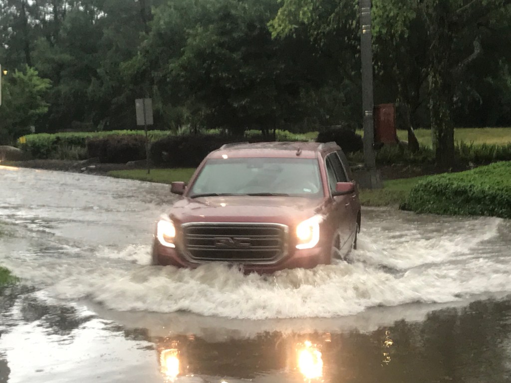
Expect Heavy Rain Late Tonight but More Likely on Wednesday
Showers and thunderstorms are expected to develop tonight as a surge of tropical moisture approaches Southeast Texas and merges with a low coming from the west.
Rainfall rates could reach 2 to 3 inches per hour at times. Widespread rainfall totals of 2 to 4 inches are expected across Southeast Texas by Wednesday evening with isolated totals exceeding 6 inches. The heaviest rainfall is expected to fall along and east of the I-69/US 59 corridor.
Those totals are close to what we experienced in early May.
Jeff Lindner, Harris County Meteorologist warned, “A low level convergence boundary may become established between the US 59 corridor and the coast and help to organize and focus thunderstorms and heavy rainfall. This pattern remains in place Wednesday and Wednesday night while 91L moves up the TX coast and likely either across SE TX or just offshore over our coastal waters.”
PRECAUTIONARY/PREPAREDNESS ACTIONS
A Flash Flood Watch means that conditions may develop that lead to flash flooding. Flash flooding is a very dangerous situation. You should monitor later forecasts and be prepared to take action should Flash Flood Warnings be issued.
Street Flooding Likely; Significant Rises on Bayous/Creeks Possible
Do not drive your vehicle into areas where the water covers the roadway. The water depth may be too great to allow your car to cross safely.
If water is deep enough to cover your tailpipe, your car will stall.
Vehicles caught in rising water should be abandoned quickly. If your vehicle stalls…abandon it and seek higher ground immediately. Rapidly rising water may engulf your vehicle and its occupants and sweep them away. Move to higher ground.
Check Drains and Creeks Near You; Park on High Ground
During storms last month, yard debris (leaves, twigs, small branches, grass clippings, etc.) washed into sewers and drainage ditches. Also, in places, large trees had fallen into creeks and ditches due to bank erosion. Flooding doesn’t always come from the river. It can come from blockages anywhere in the drainage system.
So while the weather is still nice today:
Make sure your drains are clear
Do not stack branches or garbage where they could back up water
If you live near a creek or drainage ditch, walk it. Look for downed trees. Focus on areas downstream from you that could back water up onto your property.
Report clogged street drains to City of Houston by calling 3-1-1. Have address ready when you call.
Move valuables and important papers to an upper floor or top shelf.
Make sure your cell phone and weather radio batteries are fully charged; have backup batteries in case of power outages.
Remember, streets are DESIGNED to be part of the floodwater retention system. They are meant to hold excess water until the ditches, creeks, streams and bayous can absorb it. So don’t park in the street if you can avoid it.
Attention Vacationers: Coastal Forecast is Rough
Winds will begin to increase this afternoon and evening over the coastal waters which will help to build seas on Wednesday. Tides are forecasted to reach near 3.5-4.0 ft on Wednesday which may cause minor coastal flooding on Bolivar and low lying coastal area on the west end of Galveston, Surfside, and in SE Harris County. A coastal flood advisory may be required on Wednesday.
Posted by Bob Rehak on 6/4/19
644 Days after Hurricane Harvey
https://i0.wp.com/reduceflooding.com/wp-content/uploads/2019/06/noaad2.gif.png?fit=887%2C640&ssl=1640887adminadmin2019-06-04 12:55:072019-06-04 12:55:16Flash Flood Watch In Effect from Midnight Tonight Through Thursday Morning: Simple Ways to Reduce Flood Risk
SB 7 establishes special funds dedicated to flood mitigation. The bill creates dedicated Texas Infrastructure and Texas Infrastructure Resiliency Funds for flood control planning and the funding of flood planning, mitigation, and infrastructure projects.
Money from SB 7 could help fund additional flood gates for the Lake Houston spillway. They could help release water faster before and during floods such as Hurricane Harvey.
Within 90 days, a Texas Infrastructure Resiliency Fund Advisory Committee will submit recommendations to the Texas Water Development Board (TWDB) on rules it should adopt in administering the fund. TWDB has another 90 days to adopt rules governing the fund. After that, on or before the end of this year, the TWDB may begin financing projects in the state flood plan.
The bill itself takes effect immediately because it passed both the House and the Senate by more than a two-thirds majority. The Senate passed it 31-0. The House passed it 143-1 with two present but not voting. However, Article Two of SB 7 – the part dealing with the infrastructure fund – takes effect on January 1 of 2020 ONLY IF VOTERS APPROVE a constitutional amendment in November. If voters do NOT approve the constitutional amendment, Article Two has no effect.
Flood Mitigation Funding: SB 500 Implementation
SB 500 is an all-purpose special appropriations bill. It appropriates money for SB 7 and other Hurricane Harvey relief projects. For instance, it include $30 million to help dredge where the San Jacinto meets Lake Houston. SB 500 passed with greater than two-thirds majorities in both House and Senate. Therefore, it takes effect immediately.
That means $30 million should be available today to help dredge the mouth bar of the west fork.
$30 million can now used to help dredge the mouth bar.
Sand Mining Inspections and Fines: HB 907 Implementation
On its way to becoming law, the Senate strengthened HB 907. In its final form, it increased inspection frequency for all aggregate production operations (APOs) from every three years to every two.
Breach in Triple-P mine in Porter allowed process water to flow directly into Caney Creek, East Fork and Lake Houston, the source of drinking water for millions of people.
HB 907 also allows the TCEQ to conduct unannounced inspections if the TCEQ investigated a complaint about an APO operation in the previous three years.
It sets registration fees for APOs at a level that will allow the TCEQ to establish an active APO registry.
Finally, it increases penalties for failure to register an APO. It set the minimum at $5000 and the maximum at $20,000 per year with the total not to exceed more than $40,000 for any three year period.
This act takes effect on September 1, 2019. It passed in the House by 135-8 with one present and not voting. It passed in the Senate 28-3.
“Sand Trap” Bill: HB 1824 Implementation
Environmental groups and citizens, including me, fought to clarify the open-ended language in HB 1824. It allows the San Jacinto River Authority (SJRA) and Harris County Flood Control District take sand and gravel from the San Jacinto without a permit in order to restore the conveyance of the river. They can also deposit the sand and gravel on private land.
Opponents feared that it would open the door to river mining because the SJRA is essentially an economic development entity that is sensitive developers. The SJRA has also shown no desire in the past to control sand mining along the banks of the river.
When I asked legislators, miners, TACA and the SJRA how it would work, I received four different answers!
Proponents of the bill sold it as “the sand-trap bill.” The idea: to get sand mining operations to dredge the river, allow them to sell the sand, and avoid taxpayer expense. By dredging at certain locations under government supervision, proponents hoped to reduce the amount of sand coming downriver. That sand reduces the conveyance of the river and contributes to flooding.
If the bill actually works that way, great. But there’s nothing in its language that indicates how it will work or whether miners will be supervised. River mining is outlawed in many countries, including most of Europe. It has been linked to the destruction of private property in many of other countries that allow it.
Watch private sand mining activity on the river closely! This bill takes effect in three months, on September 1, 2019.
Posted by Bob Rehak on 6/3/2019
642 Days since Hurricane Harvey
The thoughts in this post represent my opinions on matters of public interest and safety. They are protected by the First Amendment of the US Constitution and the Anti-SLAPP statute of the great State of Texas.
https://i0.wp.com/reduceflooding.com/wp-content/uploads/2018/10/DifferenceMapWestFork.jpg?fit=2000%2C1129&ssl=111292000adminadmin2019-06-03 07:57:322019-06-03 08:02:47Governor Signs Flood Mitigation and Sand Mining Legislation. Now, what happens when?
June 1 marks the official start of hurricane season. And, as if on cue, the National Hurricane Center issued warnings about possible tropical storm formation in the Bay of Campeche. That’s the area between the Mexican mainland and the Yucatan peninsula. It is not forecast to move toward the Houston area. Northeastern Mexico and the Rio Grande Valley, however, should keep a close eye on this one.
This area of low pressure had been centered over land in Central America. High pressure over the central US blocked it from moving north. But now that our high pressure system is moving east, it is allowing the low to move north. As it moves out over water in the Bay of Campeche, it could strengthen. The NHC gives it a 50% chance of turning into a named storm in the next five days. Regardless of formation, it’s going to produce a lot of heavy rain for our friends to the south.
Hurricane Preparedness and Education
There’s no reason to panic over this. But its timing on the first day of hurricane season should remind us all about hurricane preparedness.
One of the first things I would do: Bookmark the National Hurricane Center website (NHC). It is updated several times per day, and gives you the most current information available. It also presents information in a wide variety of formats: for mobile and desktop platforms, maps, text, satellite images, aircraft reconnaissance, etc. NHC is the definitive source for this kind of information.
It also contains links to other weather-related web sites, such as the National Weather Service and NOAA.
Finally, it contains a wealth of information about hurricane preparedness and educational pages that can help you understand these storms better.
Exploring the NHC glossary may answer questions that have had you scratching your head for years. For instance, everyone talks about the differences between tropical depressions, tropical storms and hurricanes. But what is an “invest”? You see that all the time.
Invest is shorthand for “investigative area.” It’s simply a weather system for which the NHC wants to start collecting data or running models on. Once a system has been designated as an invest, a number of government and academic web sites initiate data collection and processing.
Designation of a system as an invest does NOT correspond to any particular likelihood of development of the system into a tropical cyclone.
Peak of Hurricane Season
Hurricane season lasts from June 1 through November 30 in this area. Even though today marks the start of hurricane season, the peak isn’t for several months. September 11th is the statistical peak. Tropics heat up the most throughout August and September. Hurricane Harvey lasted from August 25 through 30 – in the middle of that window.
https://i0.wp.com/reduceflooding.com/wp-content/uploads/2019/06/two_atl_5d0.png?fit=900%2C665&ssl=1665900adminadmin2019-06-01 12:19:562019-06-01 12:20:04That Time of Year Again: Hurricane Season is Here
To date, most of the press coverage about the May 7th flood has focused on Elm Grove and North Kingwood Forest to the south of the new Woodridge Village development. However, the flood also affected many homes in Porter to the west of it. This is an interview with Gretchen Dunlap-Smith in Porter whose home was built in 1994. It flooded for the first time – after Woodridge Village started clearcutting and grading the land next to her, and wetlands disappeared.
USGS National Wetlands Inventory shows that government classified much of the northern section of Woodridge as wetlands (dark green overlays).Porter borders Woodridge Village to the west. Smith home located in white circle.
“This Area Never Flooded”
Rehak: Has this area ever flooded before?
Dunlap-Smith: This area never flooded.
Rehak: How far back does “never” go?
Dunlap-Smith: I grew up in the Kingwood area. My parents moved here in late 1976. We had 2.5 acres off of Hueni. My brother built this house in ‘94. So I’ve known this home since its inception. I saw it being built. One house at the end of the block did get water in it, but none of the other houses ever flooded. Ever!
Rehak: What do you think caused the flooding on May 7th?
Dunlap-Smith: (Pointing to bulldozers in the distance) The construction down there. That’s the only thing that’s changed. During Harvey, there was never any fear, threat, or worry in my mind that “I’m going to have water in my home.” Ever! During Harvey, during the Tax Day flood and all the stuff before that…never any concern. This (pointing to the construction again) changed the game.
We used to ride four wheelers on that property so I know there used to be a huge detention ditch and a huge pond. There used to be a natural creek down off of the end that went up to the wood line. From what I’ve been seeing and what I’ve been told, they backfilled all that in. The wetlands disappeared.
Note dirt pushed in ditch along western edge of Woodridge Village.Homes from the north end of this development in Porter all the way down to Mace and Joseph streets flooded, including Dunlap-Smith’s home on Flower Ridge.
Ditches No Longer Drain
Dunlap-Smith: Even now, the ditches don’t drain. Our ditches drained before. They never had standing water in them. You look at the ditches now and you will see green algae and moss growing in them. We never had that before. We could mow our ditches. They were dry, because the water drained. And now it doesn’t do that.
Rehak: Where did the water go before?
Dunlap-Smith: It went to the end of the road and flowed out.
Rehak: And now it’s getting to the end of the road and stopping?
Where drainage from Flower Ridge in Porter joins the new Woodridge Village in Porter.Residents say water now stands so long in altered ditches that it grows algae.
Dunlap-Smith: Right. Now it’s backing up and flooding the street.
Rehak: Were you blocked in on May 7th?
Dunlap-Smith: We got out Tuesday night when the rain receded a little bit…for like 3 hours. The water went down enough to where I felt comfortable going through it with our Nissan Altima.
Ditches Became Invisible in Flood
Rehak: These ditches are kind of…deep. If you didn’t know they were there…!!!
Dunlap-Smith: Yeah! You could really do some damage. Or worse, drown yourself in your car.
Photo by Gretchen Dunlap-Smith from May 7 of Flower Ridge in in Porter.
Rehak: How many homes in your subdivision were affected?
Dunlap-Smith: I don’t have a count. But I know that several homes flooded on our street and other streets in the subdivision.
Rehak: How high did the water get?
Dunlap-Smith: A couple inches in our house. Deeper in others.
Rehak: How much did you lose?
Saved by the Peaches!
Dunlap-Smith: Carpet. I was able to get some furniture up onto soup cans and big jars of peaches.
I put most of our furniture up on stuff like that. Hopefully, I may be able to salvage a couple rooms of carpet. Most of my house was tiled by my brother and sister. So the only rooms that had carpet were my living room and my three bedrooms.
Swamped utility room after the flood. Photo. by Gretchen Dunlap-Smith.
Rehak: Is there any concern that the water got under the tile?
Dunlap-Smith: I talked to a couple people about that. I have two dehumidifiers that have been going non-stop since the day after the flood. Those haven’t quit. I’m dumping them constantly.
Cleaning Up the House Without Flood Insurance
Rehak: How long did it take the water to recede? When you came back the next day was it out?
Dunlap-Smith: It was out of the streets.
Rehak: How about the house?
Dunlap-Smith: No. The house…I had to pull every bit of carpet out. It had not receded.
Rehak: Did you have to squeegee it out?
Dunlap-Smith: That carpet was a soaking wet mess! You see that shop vac behind you? That’s a wet/dry shop vac.
Gretchen Dunlap-Smith tries to save her carpet by drying it on the bed of her truck.
You know, this isn’t a flood zone. When we bought the home, we weren’t required to have flood insurance. We called our agent after the flood and he said we weren’t covered, but we could get coverage for four or five hundred dollars per year. But it wouldn’t activate for 30 days.
“You Sunk Us”
Dunlap-Smith: My neighbor told me that they were down there digging a ditch line, trying to open up the drainage again from the damage they had done. But you’ve already damaged natural drainage. You changed and affected how the flow goes. So I don’t care what you do now. You sunk us.
Rehak: Their plan shows a huge detention pond up in the northwestern corner of this land that they clearcut. And then there’s a linear ditch running inside their property all the way down to the bottom.
Where N1 detention pond and drainage ditch should have been before flood. Excavation still had not started weeks after flood.This area used to be wetlands before the developer “improved” the drainage.
Dunlap-Smith: Right. But that ditch is not there. And if you look down Ivy Ridge, every home has trash in front because every one of them flooded.
Trash pile at end of Ivy Ridge. Looking east toward new developmentwhere drainage used to go.
“They Will Never Build on that Property”
The gentleman behind us, when he bought his house, told us there was an easement on that property. He was told they would never build on that property and not to worry. And here they are (pointing to construction).
Rehak: I’ve heard that same story from a dozen different people!
Dunlap-Smith: You get told something and you take it as gospel truth. And you run with it. You don’t check. You don’t research it. You just believe it because they’ve been honest up until now. Which is unfortunate.
Rehak: Do you have any idea what the financial loss is so far?
Counting Her Blessings, Minus the PTSD
Dunlap-Smith: Not really. Honestly, I counted my blessings. It could have been a lot worse. I saw what those people in Elm Grove were hit with. And my husband lost everything in the ’94 flood, including his whole family home. He lived right behind where Reeves furniture used to be on 59. It’s an antique store now. He lived on Treasure Lane. In ’89 there was a flood. They lost everything. But then the one in ’94 really did them in.
As far as the financial? I’m grateful. I know it could have been worse. But I know there’s been a huge emotional cost. It triggered PTSD in my husband.
Rehak: How?
Praying as the Water Rose
Dunlap-Smith: My husband is 6’4”. Not a little guy. He dwarfs me. Works for the Harris County Sherriff’s office. Takes down inmates every day. He’s not a timid guy.
When water was coming in the house, he sat down with his head in his hands and had tears. And I’ve never seen him cry.
We both were under stress. Water’s coming in our house. I have our dogs in a kennel. And I realized then…oh my gosh. The dogs are standing in water inside their kennels. So I moved them up. My husband and I were both getting a little snippy, which isn’t in our nature. There we were. Standing up to our ankles in water in the middle of our living room. He grabbed my hand and I grabbed his, and it’s like, “OK, right here. Right now. We’re praying. Stop. We have to see this for what it is not. It’s not as bad as it could be. And now he’s seeing that.
That Sour Smell
Rehak: Are you going to have to pull out wallboard and electrical?
Dunlap-Smith: I don’t think so. That’s why I said, “I’m counting my blessings.”
Rehak: Floorboards?
Dunlap-Smith: (sighs heavily). Probably. After the first three or four days, I could smell the sour. There was a heavy sour smell. Not so much mildew, but sour.
May 15th was the deadline to dispute our taxes and ours went up like $10,000. So I’m disputing them. I fired off a letter. (She begins reciting complaints in the letter.) “Are we going to be in a flood plain now?” “Are we going to require flood insurance?” We’re not a high-income neighborhood. We don’t have money to throw at that stuff.
Rehak: What kind of assistance have you gotten from Montgomery County so far?
Dunlap-Smith: I would like to get those sticky floor tiles at cost or at a highly discounted rate. I don’t know. I would like to get a dehumidifier because they’re not doing squat about this or taking accountability. My husband and I don’t have credit cards that we can buy things with.
We bought two dehumidifiers out of our pocket. That was nearly 500 dollars. You’re living paycheck to paycheck and you want to fix your house back. My Aunt told me to call Red Cross. But I’m not going to take money out of somebody’s hands that I can see needs it more than I do. I’m not going to do that.
Wants Developer to Restore Drainage
Rehak: Let me rephrase the question. In regard to your development, what would you like to see Montgomery County and the developer do?
Dunlap-Smith: For starters, come in and dig out the ditches. Maybe lower the streets to create more capacity for the water before it gets into our homes.
Rehak: And in regard to that new development going in over there?
Dunlap-Smith: I would love to see the County force the developer to create a true, correct drainage ditch.
Rehak: Do you think the county is even aware that you flooded?
Dunlap-Smith: No. They sent out a message on Twitter saying, “Contact us if you had any flooding.” I don’t think they have any clue.
We had water backing up and leaking from our toilet. Our tub was filling up with this noxious looking water and a septic smell. It was brown.
No, I don’t think the county knows that it happened in a place that it’s never happened before. The developer says they aren’t the culprit. But they changed the drainage. And they’ve gone too far to turn back.
Rehak: You can’t put back nature the way it was.
Dunlap-Smith: Agreed. I wish the county could force them to create drainage. This flooding will happen again if things stay as they are.
Reluctant to Water Plants
Rehak: How do you feel about your future here?
Note: As with other flood victims I have interviewed, curiously, Ms. Dunlap-Smith thinks in terms of tomorrow, not next year.
Dunlap-Smith: We have a little joke here. Every time I water my plants, it rains. For some people it’s washing their cars. But I told my husband this morning that, “I’m afraid to water my plants.” So … if that tells you anything. (Laughing) I’d rather let the plants die.
On May 7, 2019, Kingwood received as much rain in one afternoon as we were expecting in a whole week of heavy rains. This wasn’t just street flooding. It was street flooding on steroids…as these pictures and this video show.
Submerged car on Kingwood Drive between Taco Bell and Congressman Dan Crenshaw’s Office. Afternoon of 5/7/2019 when Kingwood received up to 10 inches of rain.Car trying to get out of deep water on Kingwood Drive. If the water level gets over your tailpipe, it will kill your engine.Street flooding on steroids. Inside the home of Keith Stewart on May 7, 2019. From Elm Grove subdivision.“My wife and kids are panicking…”Looking for a way out of Kingwood at rush hour, with Kingwood Drive cut off, Kaaren Cambio attempted to find a way out through Trailwood. Not much luck there!
Remember, no matter how frustrated you get, losing your car or your life isn’t worth it. Cambio said she turned around and sheltered in the fire station on Kingwood Drive until traffic started moving again. Very smart lady!
When all this is over, we need to have Kingwood-wide storm drain inspections. Not all streets flooded equally. Some fared well. Others didn’t. We need to identify the streets with blocked drains and collapsed sewers before hurricane season gets here. Hey, we all passed Proposition A, didn’t we? Let’s dip into that lockbox for drainage fees and fix some drainage problems.
Posted by Bob Rehak on May 7, 2019 at 10:30 pm
616 Days since Hurricane Harvey
https://i0.wp.com/reduceflooding.com/wp-content/uploads/2019/05/Dead-Car.jpg?fit=706%2C1078&ssl=11078706adminadmin2019-05-07 22:22:092019-05-07 22:48:08Street Flooding on Steroids
River restoration may never be completely possible in an urban environment between two major dams. Especially with 20 square miles of sand mines immediately upstream. However, as we seek to reduce sedimentation via various strategies, it’s useful to have a high-level goal in mind, so we can evaluate the usefulness of those strategies in getting us closer to the ideal.
Sand mine dikes along the San Jacinto restrict the floodway and often blow out during floods. During Harvey, 131,000 cubic feet per second swept through approximately 20 square miles of sand mines on the West Fork. Floodwaters also eroded banks up and down the river, resulting in excess sedimentation.
Will SB 2126 Help Restore the River?
SB 2126 is a senate bill designed to reduce sedimentation by removing it from the river in unspecified ways, no permits necessary. I fear that the vagueness in the language could open the door to river mining on the San Jacinto. It passed the Senate yesterday 21-10 without any amendments to clarify the language.
Although proponents talk about restrictions on the practice, the language of the bill contains none.
A Leading Expert in River Restoration
After reading SB 2126, a reader recommended consulting Dave Rosgen, PhD, a ProfessionalHydrologist and Geomorphologist, to see what he would recommend. His field experience in river work spans 49 years. Twenty of those were with the U.S. Forest Service. He developed:
A stream classification system
The BANCS streambank erosion model
The FLOWSED/POWERSED sediment transport models
The WARSSS methodology for cumulative watershed assessment
A geomorphologic approach to Natural Channel Design restoration.
Rosgen has authored Applied River Morphology,Watershed Assessment of River Stability and Sediment Supply (WARSSS), and more than 70 reports and articles in research journals, symposia, and federal agency manuals. Time, Science, 5280, National Geographic, The Denver Post, and The New York Times have all featured his projects.
His company, Wildland Hydrology, has implemented more than 70 large-scale river restoration projects in North America, Africa, Central America, and South America.
Rosgen’s Take on River Mining Vs. Other Alternatives
I asked Rosgen, “What’s the best way to reduce unnaturally large rates of sedimentation?”
He started out by describing what NOT to do: “Letting people dredge the San Jacinto River without specific criteria for width/depth ratio and multi-stage channel shape will ensure that sediment deposits return. There are several complex issues in post-flood restoration.”
“A very large portion of sediment supply during high flows is from streambank erosion. If this supply is not reduced, a future repeat is guaranteed along with land loss and increased flood risk. We use toe wood and woody riparian on a bankfull bench against steep high eroding banks to reduce erosion rate and sediment supply in anticipation of future high flows.
“You must shape a channel with a low flow (inner berm) channel, a bankfull channel (normal high flow), and a floodplain surface to efficiently transport sediment. Just dredging and over-widening a channel will result in rapid sediment deposition during normal flows as well as floods.
“The backwater created by the lake will always induce sediment deposition. That’s why you need to reduce the sediment source or supply.
“Shaping a multi-stage channel helps distribute sediment following a lowered lake stage level.
“Lake levels should be lowered in advance of anticipated runoff events (or during hurricane seasons) to provide more detention storage and reduce the elevation of upstream backwater.
Giving carte blanche for uncontrolled dredging is a license for continued failure without regard to the basic fundamentals. – Dave Rosgen, PhD
Success in Houston Area
“Where toe wood has been placed with good restoration design in the Houston area, it held up well to Harvey. We have implemented these recommendations successfully in your area,” says Rosgen.
“I am about a year away from publishing a book on river restoration. It will describe design details. Uncontrolled dredging is a short-term solution to a very big problem. That problem can be solved, but not without expense and good designs.”
In conclusion, Rosgen said, “Uncontrolled river mining will make things worse due to channel adjustment, including increased bank erosion. That’s because a lowered stream bed increases bank height. That will cause new bars to develop rapidly. Hope this helps alert you to problems you will face.”
Giving Nature a Chance to Heal Itself
We are 30 days away from the end of this legislative session. SB 2126 may or may not have enough backers to put it on the governor’s desk. If it gets there, I hope the legislature spells out restrictions. The way it’s worded right now could open the door to wholesale river mining.
On the other hand, we are about 18 months away from the completion of the San Jacinto River Basin Study. Hopefully, we can use that time to inform the community about river restoration strategies and options. When complete, the study may illuminate the way forward.
Efforts as large as this won’t happen overnight. It may take decades and legislation requiring greater sand-mine setbacks. We need to give nature a chance to heal itself.
Posted by Bob Rehak on 5/1/19
610 Days since Hurricane Harvey
https://i0.wp.com/reduceflooding.com/wp-content/uploads/2019/04/Harvey-SanJac_56.jpg?fit=2000%2C1333&ssl=113332000adminadmin2019-05-01 13:00:432019-05-01 13:02:51Is River Restoration Possible on the San Jacinto?
The Bayou Land Conservancy sent this letter today to the Committee Clerk of the House Environmental Regulation Committee. The Conservancy has allowed me to publish it:
On behalf of Bayou Land Conservancy, I urge you to vote FOR HB 909 when the Environmental Regulation Committee meets to consider this bill. Bayou Land Conservancy is a non-profit, community-supported land conservation organization that preserves land along streams for flood control, clean water, and wildlife. We preserve 14,000 acres in the Houston region, focused on the Lake Houston watershed. This includes the San Jacinto River, cited in 2006 as one of America’s most endangered rivers due to a number of threats, including the high intensity of local aggregate mining.
HB 909 would require the Texas Commission for Environmental Quality (TCEQ) to adopt and make accessible best management practices for aggregate producers to comply with applicable environmental laws and rules.
This adoption of best management practices would be an important, and needed, step to ensure that aggregate production in Texas is done with sensitivity to the environment and to community standards. As the population of Texas continues to grow, with the corresponding increase in construction of buildings, roads, and bridges, there is greater risk to the quality of life and safety for many communities located near mining operations.
As one of the nation’s leading aggregate producing states, we know Texas can lead in developing higher standards. We recommend best management practices that consider community values, such as:
Employ public notice and stakeholder process guidelines to ensure mining operations are in step with local priorities and concerns
Maintain setbacks or standards for siting operations away from sensitive areas or those with the highest likelihood to cause impacts
Develop environmental impact statements for proposed mining operations
Enact mitigation standards to reclaim the project area after facility closure
Utilize progressive reclamation with a step-be-step restoration of the site over time rather than waiting for final closure
Require the submission of an approved reclamation plan prior to permit approval
Require the certification of financial security to perform reclamation activities before permit approval
Require post-use conservation easements to ensure that the floodplain is left undeveloped and can provide a community amenity opportunity.
There is urgency for Texas to lead by enacting commonsense solutions that protect the community.
Without development and implementation of best management practices, such as those outlined above that would keep sediment in place through floodplain preservation and mine reclamation, downstream communities will continue to be at risk of water quality degradation and flooding.
Please vote YES on HB 909.
(Signed) Jill Boullion Executive Director
Please Support HB 909; Here’s How
Call. Write. Or testify in person TODAY. The committee meets to consider this bill tomorrow. The following representatives comprise the Environmental Regulation committee.
Rep. J. M. Lozano (512) 463-0463
Rep. Ed Thompson (512) 463-0707
Rep. César Blanco (512) 463-0622
Rep. Kyle J. Kacal (512) 463-0412
Rep. John Kuempel (512) 463-0602
Rep. Geanie W. Morrison (512) 463-0456
Rep. Ron Reynolds (512) 463-0494
Rep. John Turner (512) 463-0576
Rep. Erin Zwiener (512) 463-0647
Committee Clerk: Scott Crownover. (512) 463-0776
If you can come to Austin to testify, please do. The meeting will be held Wednesday, May 1, in room E1.026 of the Capitol Building. Most likely hearing time is in the evening around 8 p.m., but get I plan to get there early. Hope to see you there.
Posted by Bob Rehak on April 30, 2019
609 Days since Hurricane Harvey
https://i0.wp.com/reduceflooding.com/wp-content/uploads/2019/03/capitolc_1024.jpg?fit=1024%2C768&ssl=17681024adminadmin2019-04-30 10:12:192019-04-30 10:15:35Bayou Land Conservancy Supports HB 909, Publishing Best Practices for Sand Mining
Dave Martin provided this report this morning to the Lake Houston Area Recovery Task Force monthly meeting at the Humble Chamber of Commerce. Compared to the post I published last week,it provides additional details about developments in recent months regarding the San Jacinto West Fork mouth bar. Council Member Martin has given me permission to reprint his report. Here it is verbatim.
Great Lakes Dredge and Dock is working downstream from River Grove Park on an area nicknamed “sand island.” See upper left corner of home page. Most of sand island is gone now. The dredging company hopes to complete this phase of West Fork Dredging by May 4.
To: Lake Houston Area Recovery Task Force Subject: Post Harvey Dredging Timeline From: Council Member Dave Martin Date: April 1, 2019
Task Force Members,
Immediately after Hurricane Harvey, our District Council office, in partnership with the Lake Houston Area Chamber of Commerce, initiated our area’s “Plea for Three” campaign as a way to draw attention to the need for Remediation, Reduction (Lake Conroe), and Representation. The Plea for Three clearly identified the post-Harvey needs of the community for dredging, detention, and a community voice on the board of the San Jacinto River Authority.
Following the “Plea for Three” was the “Plea to See”, which culminated visits to the Lake Houston area by Governor Greg Abbott on March 15, 2018, Texas Land Commissioner George P. Bush on March 22, 2018, and Lieutenant Governor Dan Patrick on April 4, 2018.
As a direct result of tours to our neighborhoods and tributaries, City of Houston and State Officials engaged with Federal Emergency Management Agency (FEMA) to discuss the removal of debris within the West Fork of the San Jacinto River resulting from Hurricane Harvey. The specific concern for the debris included eight miles of newly deposited sediment starting from the confluence of the river at Lake Houston, to the upstream crossing of US Interstate 69 over the river. Several meetings have taken place with federal and state agencies to include additional portions of the reach for debris removal, and expansion of the existing dredging operation is needed to provide relief to the area.
On April 2nd, 2018, representatives of the City of Houston and Harris County Flood Control District attended a meeting at the Texas Joint Recovery Office in Austin. Numerous agencies were represented at the meeting including Texas Department of Emergency Management (TDEM), FEMA, and the United States Army Corps of Engineers (USACE). At the meeting the local representatives were informed by FEMA they were issuing a mission assignment to the USACE to develop a dredging project along the West Fork of the San Jacinto River. The USACE was to be responsible for determining the scope of work, preparing dredging plans, locating disposal sites, bidding the project, and managing the construction operations. An analysis was completed, construction plans were developed, and project was bid in June 2018. The reach to be dredged was determined to include approximately 2.5 miles upstream and downstream of the crossing of West Lake Houston Parkway. Dredging began early fall in September of 2018.
Due to the limited scope of the USACE project, and growth of the sand bar, commonly referred to as the mouth bar, located at the confluence West Fork of the San Jacinto with Lake Houston, and observed through historical aerial maps, our office indicated the need for the scope of dredging operations to be expanded. On October 11th, 2018, a meeting was held with representatives from TDEM, FEMA and the USACE to discuss this request. The City engaged the Texas Water Development Board (TWDB) to obtain a bathymetric survey in combination with LIDAR data of sand deposits above the waterline.
Through this exercise, City of Houston consultants were able to determine total volume of material deposited. At the meeting, FEMA requested for the USACE to review the data provided by the City’s consultant. The City was also advised by the USACE that future dredging operations would require a new disposal site since the current USACE operations would utilize the two existing disposal sites to their full capacity. This triggered the identification and permitting of a new disposal site with Lake Houston resident Mr. Berry Madden.
On December 10th, 2018, TDEM and FEMA conducted a meeting with representatives from the City and Harris County Flood Control District to discuss ongoing local recovery efforts including the possible dredging project at the mouth bar. Representatives from the USACE office were also present. At the meeting, the City was advised that USACE staff was unable to determine, with any level of accuracy, the volume of debris material deposited near the mouth bar directly associated from Hurricane Harvey. They indicated that additional data collection would be required but indicated the USACE did not have the resources, funding and staffing available to perform the necessary tasks. The City agreed to meet with the USACE staff to discuss their initial findings and outline an acceptable method to obtain the required data.
On December 14th, 2018, a follow up meeting with the USACE was held in which staff provided the City a map highlighting the limits of focus area for data collection. USACE staff also recommended the City contact a geomorphologist to assist in the data collection and analysis, and recommended Dr. Tim Dellapenna, a geomorphologist from Texas A&M Galveston. Dr. Dellapenna submitted a proposal based upon a lump sum payment, however FEMA would not accept a lump sum payment schedule and then directed the City to ask Texas A&M for a “time and materials” contract, which A&M would not accept.
Due to the USACE demand for a “time and material” contract, the City elected to utilize Tetra Tech, our recovery consultant, to provide the services on a time and materials agreement, as Texas A&M continued their non-acceptance of such a contract.
The methodology utilized for the analysis is comparable to the “Stockton Protocol” for identifying storm deposited sand in bodies of water, which has been previously approved by FEMA for Hurricane Sandy recovery efforts in New Jersey. The City received the draft final report on March 23rd, 2019 and is currently reviewing the results. The final report will be submitted to TDEM and FEMA on March 29, 2019.
On a parallel path, pursuant to the USACE instruction at the October 11thmeeting, the City has explored possible disposal sites for the future dredge material. Mr. Berry Madden, local property owner offered a site on the south bank of the river, upstream of the USACE project reach. On October 31st, 2018, on the advice and counsel provided to the City by the USACE, a Nationwide Permit 33 application was submitted to the USACE pursuant to 33 CFR 330 to enable constructing a temporary dredge pipeline across wetlands on the disposal site.
On January 29th, 2019, a meeting was scheduled with representatives from the USACE environmental group where the City was informed the permit application would need to be revised and re-submitted as an Individual Permit rather than a Nationwide Permit, contrary to what we were advised by the USACE during our October 11thmeeting. One of the major issues was related to the absence of a defined project for which the disposal site is required. As such, the permit application has been revised to an Individual Permit reflecting the project and data from the Tetra Tech work effort previously described. The permit application was submitted the week of March 29th, 2019. This permitting project has been under the direction of Berg Oliver Associates, Inc., an Environmental Services and Lake-Use consultant.
As previously outlined, this project was first discussed on October 11th, 2018, with the intent to extend the USACE’ scope of work to include dredging at the mouth bar. Timing has been critical since the City would utilize the same USACE contractor before the USACE project is completed to avoid paying for additional mobilization costs. The total USACE project cost, as bid, is $69.8 million including $17.9 million for mobilization. However, an Individual Permit for the disposal site will have a significant delay in processing and thereby impact the timing. A more pressing issue is related to FEMA’s determination and confirmation on whether the material proposed to be dredged will qualify as debris removal activity under “Category A” recovery expense. In the event of an adverse ruling from FEMA, the City would have to cover the entire costs in lieu of the recovery local match of 10%. The next steps for obtaining additional work and expansion of dredging operations along the West Fork of the San Jacinto River include obtaining the USACE permit and receiving confirmation from FEMA.
Sincerely, (Signed) Council Member Dave Martin
Posted by Bob Rehak on April 1, 2019
580 Days since Hurricane Harvey
00adminadmin2019-04-01 17:04:502019-04-01 17:05:40Houston City Council Member Dave Martin Provides Dredging Timeline
Four members of the Lake Houston Area Flood Prevention Initiative Steering Committee have sent a protest letter to Harris County Judge Lina Hidalgo. The Judges’ desire to prioritize flood bond projects based on “equity” (percent of low to moderate income (LMI) housing in communities) rather than flood danger has sparked a tsunami of protest.
Homes in Barrington in 500-year flood plain during Harvey. Photo courtesy of Julie Yandell. She was forced to flee with her husband and 81-year-old neighbor when waters rose without warning.
Changing the Contract After the Sale?
Many community leaders feel the bond was sold as one thing and is being rolled out as another. At 23 community meetings throughout the county last year, county leaders emphasized that the worst areas would be addressed first, though they did create exceptions for work in progress or work that was shovel ready.
Judge Hidalgo first raised eyebrows on social media when she made the LMI suggestion at a Commissioner’s Court Meeting last month. Then early this month, the Judge’s staff and Flood Control leaders began briefing selected community representatives on how that might work. Even though the ideas were presented as trial balloons designed to elicit feedback, local television and news outlets soon got wind of the ideas.
Factors in Initial Proposal
A flood of criticism followed when people saw how projects in the Lake Houston Area could be delayed. Initial guidance indicated that some low-ranking projects could take 10 to 15 years to implement.
Version 1.0 of the prioritization attempted to rank order projects based on seven factors, each given different weights. The factors and weights were:
Existing Conditions Drainage Level of Service (How Bad Things Currently Are) – 20%
Equity (LMI) – 20%
Flood Risk Reduction (Looking only at # of Structures, not their Value) – 20%
Long-Term Maintenance Costs – 5%
Minimizes Environment Impacts (Gauging Possible Delays due to Environmental Permitting) – 5%
Potential for Multiple Benefits – 5%
Project Efficiency (Cost of project/# of Structures Benefitted) – 15%
Problems with Version 1.0
According to version 1.0, a $60,000 house counted for as much as a $600,000 house, or a $60 million high school. There’s a certain egalitarian appeal to this. Neither rich, nor poor, should be disadvantaged when it comes to flooding. Counting structures without factoring in their value evens things out.
However, the plan also has many drawbacks. It ignores the immense cost of damage to infrastructure, for instance. Maybe a $60 million high school for 4000 students should count for more than a single-family home for four. Against this background, the leaders of the Lake Houston Area Grass Roots Flood Prevention Initiative listed these concerns.
Failure to appropriately recognize benefits from multi-million dollar partnership matching grants
Failure to capture full flooding impacts and full project benefits by not considering commercial property, schools, hospitals, and senior-care facilities
Not recognizing benefits to LMI areas received from projects executed in non-LMI areas
Not considering Costs/benefits of pre-Harvey Capital Improvement Projects
Lack of inclusion of URGENT NEED criteria in the matrix
I’m told by several people who contacted the County Judge’s office today that version 2.0 may already be in the works. Let’s hope it addresses some of these concerns.
Version 2.0 may be presented at the March Commissioners Court meeting on the 12th. However, most people I talk to want more time. They are urging commissioners to hold public meetings, solicit feedback from communities, and develop support for any plan before moving forward.
Posted by Bob Rehak on 2/27/2019
547 Days since Hurricane Harvey
https://i0.wp.com/reduceflooding.com/wp-content/uploads/2019/02/IMG_0048-e1551239272900.jpg?fit=1500%2C2000&ssl=120001500adminadmin2019-02-26 21:50:342019-02-26 23:15:34Lake Houston Area Flood Prevention Initiative Leaders Protest Proposed Flood Bond Prioritization
Council Member Dave Martin would like to make residents aware that the City of Houston has launched its Homeowner Assistance Program. Here are details.
$1.17 Billion Available through Five Programs
The City of Houston has received $1.17 billion for housing recovery through the U.S. Department of Housing and Urban Development and the State of Texas General Land Office. The recovery funds will be used five ways:
Reimbursement for completed repairs
Homeowner-managed rehabilitation
City-managed rehabilitation and reconstruction
Buyouts
Interim mortgage assistance.
Available to Homeowners of All Income Levels
Priority will be given to low and moderate income homeowners. However, assistance is available to homeowners of all income levels.
Start With Online Survey
Start the application process by taking this Harvey Recovery Survey. It will help direct you to the appropriate recovery program and help the City prioritize those with urgent needs. You need nbo documentation to take the survey. t takes less than 15 minutes to complete.
Other Options to Apply
Those not comfortable with online surveys have several other options:
Call 832-393-0550 (Monday through Friday, 9:00 a.m. to 5:00 p.m.)
Or visit one of the mobile centers when it visits the Kingwood Community Center at 4102 Rustic Woods, Kingwood, TX 77345: Saturday, February 23, 10:00 a.m. to 1:00 p.m. or Wednesday, February 27, 11:00 a.m. to 1:00 p.m.
Visit the mobile unit in Kingwood or one of these permanent Recovery Centers to apply.
The nearest permanent Housing Recovery Center is at 9551 N. Wayside, Houston, Texas 77028. It is open Monday and Tuesday, from 9:00 a.m. to 6:00 p.m., Wednesday and Thursday from 10:00 a.m. to 8:00 p.m., Friday from 9:00 a.m. to 6:00 p.m., and Saturday from 9:00 to 3:00 p.m. The center is closed on Sundays.
Followup and For More Information
An Intake Specialist will contact you after you complete the Survey regarding next steps. For more information, please contact the Houston Recovery Center by calling 832-393-0550.
Posted by Bob Rehak on February 19, 2019
539 Days after Hurricane Harvey
https://i0.wp.com/reduceflooding.com/wp-content/uploads/2019/02/2543f2a6-d3f6-4b25-9d7f-d3e4145aa641.png?fit=947%2C851&ssl=1851947adminadmin2019-02-18 23:45:392019-02-18 23:45:46Mobile Hurricane Harvey Recovery Center Coming to Kingwood Feb. 23 and 27