Today, Jeff Lindner, Harris County’s meteorologist issued a report on last weekend’s (1/8/22 – 1/9/22) storm. One of the more interesting findings: According to the National Weather Service, the Kingwood tornado was the widest, strongest and longest of five that touched down in Harris County. See below.
EF stands for Enhanced Fujita Rating Scale, a table used to compare tornado winds. All these tornadoes ranked on the low end of the scale which goes up to EF-5. The scale considers 0 and 1 as weak tornadoes.
Wealth of Detail Beyond ReduceFlooding Reports
Lindner’s report confirms my “after-action” reports, but adds a wealth of details.
For instance:
Rainfall rates of 2-3 inches/hour were common in the slow-moving training thunderstorms.
That led to rapid and significant street flooding, and rises on area creeks and bayous.
The highest measured discharge (streamflow) rate was in Greens Bayou at Mount Houston Parkway – 7,067 cubic feet per second.
Lindner found that certain areas experienced 2- to 10-year rains based on Atlas-14 exceedance probabilities. Based on 1- to 3-hour rainfall rates, those included middle Buffalo Bayou, Luce Bayou, middle and upper Halls Bayou, middle Greens Bayou, middle and lower White Oak Bayou, and the lower portion of the East Fork of the San Jacinto River. However, based on 12- to 24-hour rates, all impacted watersheds experience 2- to 5-year rains.
Because the storms trained perpendicular to the direction of most bayous, the rainfall within their watersheds varied greatly. For instance:
Greens Bayou received on 0.9 inches at Mount Houston Parkway, but 6.2 inches at US59.
Buffalo Bayou received 5.2 inches in places and 0.2 in others – a 26X difference.
Like all of the work that comes out of Lindner’s department, the documentation is meticulous.
House Flooding Estimates
Contrary to previous reports, some house flooding did occur. It happened along Brickhouse Gully on the west side of Bingle Rd. Approximately 6-8 structures experienced flooding to depths of 4.0-6.0 inches.
Says Lindner, “Other isolated structures may have flooded in portions of Spring Branch due to the intense rainfall rates overwhelming street and local drainage systems. A few houses also flooded along Valley Stream downstream (east) of I-45 along Halls Bayou.”
Alarms Triggered
Unfortunately, Lindner doesn’t offer much more information about the Kingwood tornado at this time. Nor does he cover flooding in surrounding areas, such as Liberty County. However, the storm did set off a number of alarms.
The storm triggered 26 rainfall alarms when gages received more than an inch of rain in 15-minutes.
Rising water triggered 14 flood warnings when streams reached 3 feet below bankfull.
For detailed maps, rainfall rates, and exceedance statistics at dozens of locations, see Lindner’s full report. Note: on major storms, Lindner often issues an immediate report and a final report several weeks later. This report falls into the “immediate” category. For future reference, you can also find this report under the Major Storms tab on the reports page.
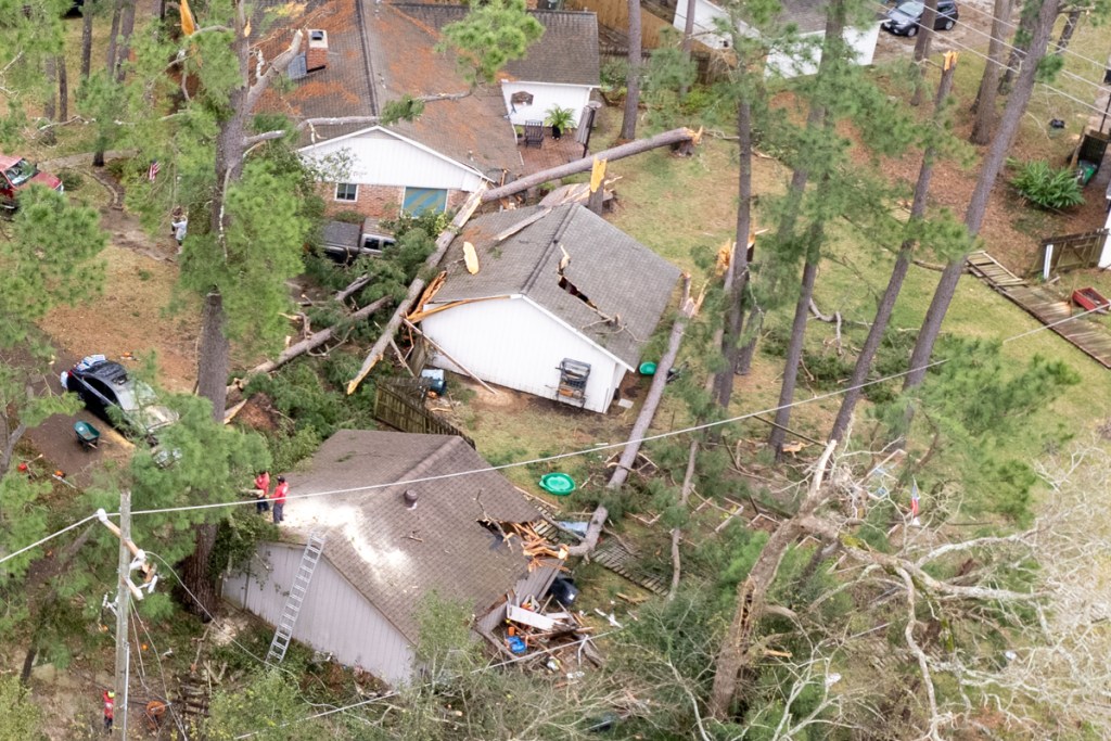
Early Sunday morning on January 9, 2022, an EF-1 tornado touched down along the Kingwood Diversion Ditch between Hamblen and Kingwood Drive. It damaged trees and homes on both sides of the ditch for several blocks. By early afternoon, tree crews were swarming over the area, making the streets barely passable.
Tornado or Just Strong Winds?
I asked one of the crews if they were sure a tornado caused the damage. They said yes, based on the type of damage they saw. The tops of trees had been twisted off like screw caps. See photos below taken on Sunday afternoon after the storm cleared out.
Note two garages and corner of one home damaged by toppled trees east of ditch.
While some trees were uprooted, the vast majority of the damage involved “topped trees.” Had straight line winds been the cause, you would see more uprooted trees. The damage would have been more widespread. And the trees would have been pushed down in a uniform direction rather than scattered like pick-up sticks.
Looking south along Kingwood Diversion Ditch. Note eight topped trees left of the ditch and one of the tops hanging from a wire over the ditch.
West of ditch on Forest Cove side. Note damaged garages, back corner of home, and trees still hanging from wires.
Close up of topped tree and blown-over fence.
Portion of fallen tree thrown through fence by winds.
Forlorn homeowner on crushed gable. “Where do I go from here?”
ABC-13 confirmed the strength of the tornado on its evening news tonight. According to ABC, the tornado came through at approximately 1:30 AM. According to residents I spoke to, the noise was deafening and pets started acting nervous about that time.
Dogs Knew Before You Did
This article from Psychology Today explains that dogs’ hearing is four times more sensitive than humans’. That means they can hear things four times farther away – sooner than we can. Canine hearing also picks up higher pitched sounds. If the noise sounds deafening to you, think how painful it must be for your pooch.
I live near Kingwood High School two miles away. At precisely 1:30, my dog started whimpering, trembling, and tried to jump in bed with me.
Storm Totals Compared to Record and Climate Norm
For the record, the storm that started Saturday afternoon and ended early Sunday morning dumped about 4.96 inches in my rain gage. Jeff Miller, an Elm Grove resident said he had 5.5 inches in his.
These are unusually high amounts for January. The all time record for January 8 was 5.89 inches, set in 1891, 130 years ago! Houston usually receives 3.4 inches for the whole month of January. Plum Grove on the East Fork received 6.88 inches in this storm – more than double the monthly average for the Houston area. Luce Bayou on 321 in Liberty County received an incredible 8.56 inches in the storm. Had either of those locations been the official recording station, this storm would have gone down in history.
Posted by Bob Rehak on 1/9/2022
1594 Days since Hurricane Harvey
https://i0.wp.com/reduceflooding.com/wp-content/uploads/2022/01/20220109-DJI_0404.jpg?fit=1200%2C800&ssl=18001200adminadmin2022-01-09 19:55:532022-01-10 20:44:59Pics of Tornado Damage in Kingwood/Forest Cove
In the “better late than never” department, the City of Houston officially launched its Harvey Economic Development Program today. The program offers aid to small businesses damaged by Harvey. This comes four years after the storm that brought Houston and thousands of its businesses to their knees.
After flooding during Harvey, the shops in this retail center are still vacant four years later.
This is kind of like sending out birth announcements for someone’s funeral – a little late. If it weren’t for the fact that most of the impacted small businesses who really needed this help probably died after the storm, like those above, I would be laughing now instead of crying.
Without further editorial comment, I will simply reprint the press release that I received this morning.
Text of Press Release
Headline: City of Houston officially launches Harvey Economic Development Program
Subhead: City’s small business revitalization effort makes first awards to restore capacity to microenterprises impacted by Harvey
Exact Text: The City of Houston has awarded its first small business grants through the Harvey Economic Development Program, part of the City’s long-term recovery plan. The program offers up to $150,000 to small businesses that suffered damages during Hurricane Harvey. The first awards – totaling $562K – went to six local business owners, including three women-owned construction companies, an oil and gas supply company, a real estate agency, and a women-owned transportation firm.
“A big part of building a more resilient city is attending to the recovery needs of small business owners, especially minority and women-owned, who may not have the resources to fully recover otherwise,” said Houston Mayor Sylvester Turner. “These small businesses bring jobs, support community growth, and help build a strong network of entrepreneurship, especially for disadvantaged communities. While this program directly invests in business owners, we will build our entire city forward as a result.”
The program provides aid to businesses that are most vulnerable and have limited access to capital, specifically focusing on microenterprises — businesses of 1-5 employees. Qualifying microenterprises must have been in businesses at the time of the storm, be current on federal business taxes, and have proof of Hurricane Harvey’s impact.
“The impact of external shocks like Harvey sets business owners, particularly small minority- and women-owned businesses, back for years to come,” explained Dr. Paula Pineda, who leads the Economic Development team at the City of Houston Housing and Community Development Department. “Serving microenterprises exclusively has allowed us to assist Houston’s ‘mom and pop’ small businesses that were disproportionately set back and yet disproportionately excluded from resources such as the PPP [Paycheck Protection Program] loan.”
Approximately $2.5 million in grants are in the approval pipeline, with awards ranging from a minimum of $75,000 to the maximum amount of $150,000. The program is succeeding in soliciting applications – 200 since its soft launch – from historically disadvantaged businesses: the majority of applicants are minority-owned and/or women-owned. All applicants who receive the City’s recommendation must be approved by the Texas General Land Office, which has been a strong supporter of the City’s microenterprise initiative.
A total of $24.9 million has been allocated for the Small Business Grants program, which aims to serve between 150 and 250 microenterprises. The Harvey Economic Development Program is one of eight prongs of the City’s $835 million Harvey recovery effort, which is funded by the U.S. Department of Housing and Urban Development (HUD) and managed by the City’s Housing and Community Development Department.
Information on the Harvey Economic Development Program, including eligibility details and the application, are available at recovery.houstontx.gov/hedp. There, small businesses can also find a plethora of resources, including assistance with taxes, computer access, and federal requirements. Applications will remain open through the end of 2021 or until funds have been depleted.
The City of Houston Housing and Community Development (HCDD) makes long-term investments to better the lives of Houston residents by creating opportunities for every Houstonian to have a home they can afford in a community where they can thrive. Our department will spend approximately $450 million in federal, state, and local funding this fiscal year to construct and maintain affordable homes, reduce barriers to homeownership, support the work of social service providers, build public amenities, and facilitate disaster recovery efforts. Learn more about programs and resources for Houstonians at www.houstontx.gov/housing.
Five Comments
Those who apply should ensure they have all the documents requested in the application. HUD required dozens of docs for housing assistance. But 36% of the applications had NO supporting documentation.
The deadline is December 31, 2021 11:59 PM (CST).
The so-called soft-launch started February 15. It took more than 6 months. Now, after the official launch, only 4 months are left.
This tardiness of this program makes a great case for “business interruption insurance.” Small business owners should ask their insurance agents what that is and also ask for a quote. I got it for my business about a year before Hurricane Ike knocked out power in the Lake Houston Area for three weeks. It was a lifesaver. And it didn’t take four or five years to recoup lost income.
Someone needs to coordinate the copy in the City’s website, the City’s press releases and the State’s approved action plan. For instance, the action plan lists the maximum award at $250,000. The website says $100,000 in one place and $150,000 right next to the first mention. The press release says $75,000 to $150,000. Another example: The City’s website says 400-500 businesses have already been served. But the press releases says the City has only solicited 200 applications. And the City’s Pipeline Report shows none are in the works. It doesn’t even list the program.
Note conflict in adjacent copy. Screen capture from City application page on 7/28/2021.
For the launch of an important new economic development program, you would expect these details to be worked out.
Posted by Bob Rehak on 8/28/2021
1458 Days since Hurricane Harvey
https://i0.wp.com/reduceflooding.com/wp-content/uploads/2018/09/KingsCrossing_16-e1630026745789.jpg?fit=1200%2C800&ssl=18001200adminadmin2021-08-26 20:19:032021-08-26 20:19:08City of Houston Officially Launches Harvey Economic Development Program
At 8AM EDT this morning, the National Hurricane Center issued an update for that blob of moisture in the Bay of Campeche that forecasters have focused on for a week now. Last weekend, its chance of tropical formation was 20%. NHC now gives it a 70% chance. NHC also has it headed, like a billiard ball, toward the side pocket in the Gulf of Mexico between Houston and New Orleans.
Continued Intensification, But Little Movement in Next 2 Days
Disorganized showers and thunderstorms continue over the Bay of Campeche and southern Mexico in association with a broad low pressure area. This system is expected to move little during the next day or two, and any tropical formation should be slow to occur during that time period. Chances of formation in the next TWO days are still at 20%.
However, the disturbance should begin to move northward by Thursday, and a tropical depression is likely to form late in the week when the low moves across the central or northwestern Gulf of Mexico.
National Hurricane Center
Regardless of development, heavy rainfall will continue over portions of Central America and southern Mexico during the next several days. Heavy rains could also begin to impact portions of the northern Gulf Coast on Friday.
Where Will Storm Come Ashore?
Jeff Lindner, Harris County’s Meteorologist, notes that the area currently has no defined low-level, low-pressure system. Global models, he says, show a trough lifting north on Thursday with better chances for low-pressure system formation.
The general consensus of the global models continues to indicate a track toward the north or northeast, but uncertainty remains about the final track. Expected wind shear over the western Gulf, conditions in the western Gulf, “a fairly disorganized system is expected,” says Lindner.
Even if the storm heads toward Houston, the dirty side would likely be to our east and southeast Texas would likely see minimal impacts.
Expected Impacts
Impacts will likely focus around increasing tide levels as higher and longer swells approach the coast this weekend. But at this time, Lindner believes tides should remain below flooding levels. He expects to know more later in the week as the storm approaches. Rain chances may increase also if some moisture can wrap around the western side of the circulation, but any heavy rainfall and flooding threat should focus east of our area.
Tropical Storm Bill Has Formed in the Atlantic
Also note that Tropical Storm Bill has formed in the Atlantic with 60 MPH winds and is headed northeast. At this time, it does not pose a threat to land.
Finally, a tropical wave has moved off the western coast of Africa. It is slowly moving west. But due to strong upper level winds and dry air aloft, NHC gives this area only a 10% chance of tropical formation.
Two weeks into hurricane season, the Atlantic Basin is already looking at triple threats. Experts predicted an above average season. This could be the start.
Posted by Bob Rehak on 6/15/2021, based on information from NHC and HCFCD
1386 Days since Hurricane Harvey
00adminadmin2021-06-15 10:27:042021-06-15 10:33:03High Chance of Tropical Formation for Disturbance in Gulf as It Heads North
After a few drier days during the Memorial Day weekend, wet weather is returning and will last into next week. We should see a high chance (50% or greater) of thunderstorms every day for the next week.
Pattern Similar to Last Month Setting Up
According to Harris County Meteorologist Jeff Lindner, the upcoming pattern will resemble the heavy rains of early last week and similar patterns in 2015 and 2016. Slow moving low-pressure systems over the southwest US will send multiple disturbances across Texas starting today and lasting into early next week.
Harris County Flood Control inspects damage from heavy rains in May to recently repaired Ben’s Branch. Photo courtesy of Chris Bloch.
Onshore winds will ensure a steady influx of Gulf moisture, high humidity and rainfall production. Disturbances will emerge from northeast Mexico into central and south central Texas nearly every day. Clusters and complexes of thunderstorms will develop and move east into the Houston region.
Difficult to Precisely Predict Heavy Downpours
“When exactly each disturbance will rotate out of Mexico is uncertain. And what state the local air mass will be ahead of each disturbance will also be hard to determine,” said Lindner.
But this pattern, he continued, “will support complexes and clusters of thunderstorms from Tuesday onward – with both a heavy rainfall and marginal severe weather threat. Some days will likely have higher threats of both.”
Widespread rainfall of 3-5 inches is likely over the next several days.
Jeff Lindner, Harris County meteorologist
While our minds may be inclined to spread such totals out evenly over the course of 5-7 days, “that is usually not how it works,” warns Lindner. “At this time of year, we could see 1-3 inches fall in a few hours or less as clusters and complexes move across the region.”
Grounds are still wet from the 10-15 inches of rainfall in May. It will not take much rainfall to trigger run-off and renewed rises on area watersheds, especially as rainfall totals accumulate over time.
Posted by Bob Rehak on 6/1/2021, based on information provided by HCFCD
1372 Days since Hurricane Harvey
https://i0.wp.com/reduceflooding.com/wp-content/uploads/2021/06/Screen-Shot-2021-06-01-at-8.49.26-AM.jpg?fit=1200%2C658&ssl=16581200adminadmin2021-06-01 09:55:452021-06-01 10:06:27High Chance of Thunderstorms Every Day into Next Week
Construction of State Highway 99 Segment H has pushed far south of FM1960 as you can see in the photo below. The segment extends eastward from Valley Ranch in Montgomery County at US59 eastward to Colony Ridge in Liberty County. At that point it turns southward toward I-10.
Looking ESE. FM1960 extends from bottom center to upper left. The other highway is SH99.
State Highway 99 is also known as the Grand Parkway. It will form a 180-mile circumferential highway traversing seven counties in the Greater Houston area. Conceptualized in the early 1960s, it is divided into 11 segments designated A through I-2.
Yesterday, I followed Segment H past Colony Ridge to FM1960, at which point the helicopter had to return to Intercontinental Airport for fuel.
This NASA image Google Earth shows how much progress TxDoT has made since last December.
Comparing the image above to the latest update in Google Earth Pro on 11/16/2020 shows progress since then.
We followed the construction almost 10 miles through prime farmland. Transportation access will open this whole area up to new development. Along the way, we saw bridges being built where there were no roads. This could have been to let farmers access land that the highway bisected. However, the bridges were far wider than needed for farm equipment. It makes one wonder whether the bridges are also being built in anticipation of future development.
Bridge over no road. Much wider than needed for farm equipment. Note size of construction trucks for comparison.
Also note the size of the bridge below over a gravel road. Someone is thinking ahead!
TxDoT State Highway 99 bridge over gravel road.Supplying a growing population will take plenty of water. In this photo, you can see SH99 going over the Inter-Basin Transfer Project.
The Interbasin Transfer Project is designed to bring water from the Trinity River to Lake Houston.
Where Inter-Basin Transfer Project joins Luce Bayou, the East Fork San Jacinto and Lake Houston.
All the pieces of a giant puzzle are falling in place to support future growth. The Grand Parkway isn’t about simply connecting two points on a map. The continued rapid growth of Colony Ridge proves that.
A small portion of the thousands of acres now being cleared in Colony Ridge. Photo taken 5/26/2021.
The questions are:
What kind of growth will Liberty County attract?
Will Liberty County enforce drainage regulations that protect downstream residents?
Posted by Bob Rehak on 5/27/2021
1367 Days since Hurricane Harvey
The thoughts expressed in this post represent opinions on matters of public concern and safety. They are protected by the First Amendment of the US Constitution and the Anti-SLAPP Statute of the Great State of Texas.
00adminadmin2021-05-27 14:00:252021-05-27 16:41:44State Highway 99 Construction Pushes South, Opening Vast Areas to New Development
The NWS has issued a flash flood warning for portions of northwest Harris County. Showers and thunderstorms have developed overnight in a SSW to NNE band over the region along a line from near Huntsville to Matagorda Bay. Storms will continue to develop and train in this band for the next several hours.
Thus far, rainfall rates of 1-2 per an hour have been observed both on radar and real time gages with storm totals upwards of 4.0-5.0 inches from Huntsville to Trinity.
Air mass is extremely moist and is capable of producing rainfall rates of 2-3 inches per hour. Street flooding will be a concern this morning for the morning rush hours.
Jeff Lindner, Harris County Meteorologist
The NWS has upgraded portions of SE TX into a moderate risk for flash flooding today (see below).
NWS has increased the risk of flash flooding for areas SW of Houston to MODERATE. That means up to a 50:50 chance.
A line of training excessive rainfall extends from near Hempstead to NW of Lake Conroe. HCFCD gages in N Waller County have recorded over 3.0 inches in the last 1-hr and an additional 2-3 inches will be possible yielding short term rainfall amounts of 4-5 inches in an hour or two. Even with dry grounds, this rainfall rate will convert quickly to run-off resulting in flash flooding.
This band of heavy rainfall will very slowly progress south and east with time this morning. Heavy rainfall move from western and northwest Harris County into NE and central Harris County.
Significant street flooding and flash flooding will be possible with these kind of rainfall rates along with rapid rises on creeks and bayous.
Most storm sewers in the Houston area are designed to handle 1 to 2 inches per hour. My rain gage received 1.2 inches in the last 20 minutes.
Band of heavy rainfall is progressing southward into northern and northeast Harris County.
HCFCD gages along FM 1960 near I-45 have recorded 1.0 inch in 15 minutes recently with hourly rates of 2-3 inches possible from Spring to Kingwood to Huffman. This band will slowly build southward into Aldine, Crosby, and Baytown over the next 1-2 hours.
Rainfall amounts of 4-5 inches over northern Waller County have generated significant rises on the creeks that feed into upper Spring Creek. A significant rise on upper Spring Creek from the headwaters to east of Hegar Rd is likely late this morning. Some impacts may be possible at Field Store Rd and other low lying road crossings on the upper portion of Spring Creek. No widespread significant flooding of upper Spring Creek is currently expected.
Street flooding is the main threat.
The SJRA has increased the volume of its release from Lake Conroe to 1590 cubic feet per second as of 7am. Despite that, the level of the lake is up to 201.68 feet. 201 is the normal target.
The Houston Planning Commission is accepting comments on proposed amendments to Chapter 42 of the Code of Ordinances, the City’s standards for new subdivision platting. One key provision has the potential to reduce flooding and deserves public support in my opinion.
Chapter 42 Amendment Comment Period is Open
The public hearing and comment period is open now and closes April 18, 2021. So hurry.
These proposed amendments will eliminate inconsistencies, clarify and/or codify some requirements and policies to make the subdivision platting process more efficient. The Livable Places Action Committee reviewed these amendments last fall and have referred them to the Planning Commission for consideration.
Special Minimum Lot Size and Special Minimum Building Line variance requirements
Temporary access easement for utility facilities
Identifying floodplains on General Plans
The new amendments would require developers to superimposition floodplain information on plats. Shown here – how the 100-year (lower dotted line) and 500-year floodplains would affect potential homebuyers.
How to Comment
Provide your comments on the proposed amendments to subdivision platting on this form. You can also email comments to LivablePlaces@houstontx.gov or call 832-393-6600.
#6 Deserves Support
Most of the changes will not affect flooding. However, #6 has the possibility to reduce flooding by making the existence of floodplains and floodways within new subdivisions more visible to potential buyers. I see this as a positive and intend to make a supportive comment. You may wish to do the same. I can almost guarantee that some interests will lobby against this provision.
Posted by Bob Rehak on 4/6/2021
1316 Days since Hurricane Harveyand 565 since Imelda
https://i0.wp.com/reduceflooding.com/wp-content/uploads/2021/04/FloodPlainInfoOnPlat.jpg?fit=1200%2C685&ssl=16851200adminadmin2021-04-06 14:03:172021-04-06 14:03:20Houston Planning Commission Accepting Public Comments on Changes to Subdivision Platting Standards
The National Weather Service has issued a flash flood watch from 6PM tonight through Thursday afternoon. In the north Houston Area, it includes:
Houston
The Woodlands
Coldspring
Trinity
Shepherd
College Station
Huntsville
Conroe
Livingston
Madisonville
The watch extends much farther north and west. It includes the Dallas/Fort Worth Area, Oklahoma, Arkansas where NWS predicts up to six inches of rain.
Where heaviest rains will fall.
Jeff Lindner, Harris County Meteorologist reports increasing risk of excessive rainfall along and west of US 59 and west of SH 288. A strong upper level storm system will combine with increasing moisture and a slow/stalling surface frontal boundary over SE TX tonight. The stalling boundary will produce training.
Lindner adds, “Heavy rainfall of 1-2 inches per hour looks possible and this could be maintained for several hours along/near the stalling front. Where the heaviest rains fall will be determine where the front slows and stalls and at this time areas from Wharton and Fort Bend into western Harris and then northward into Montgomery County have the highest chances.”
“Widespread rainfall amounts of 2-4 inches with isolated totals of 5-6 inches will be possible,” says Lindner. “We need to watch for flooding.”
Areas At Highest Risk of Flooding
While grounds west of I-45 are especially dry, Lindner predicts that the entire San Jacinto basin (west, east, and mainstem) and Trinity basins will be affected – especially in the longer term as water works its way downstream.
Northwest and western Harris County will likely see the highest totals. Responses on the creeks in those areas are likely early Thursday.
Lindner believes most watersheds will be able to handle incoming rainfall up to 4.0 inches. Should western Harris County get more, minor flooding would be possible. Especially along the lower end of South Mayde Creek, the upper end of Little Cypress Creek, the upper end of Spring Creek, and the lower end of Keegans Bayou.
As of noon on Wednesday, the SJRA shows Lake Conroe at 199.41, slightly below its normal level.
The City of Houston began lowering Lake Houston at noon Wednesday as a precautionary measure. Property owners should secure property along the shoreline. Lake levels can be monitored in real time by visiting the Coastal Water Authority website.
Heavy rainfall will end Thursday afternoon.
PRECAUTIONARY ACTIONS
A Flash Flood Watch means that conditions may develop that lead to Flash Flooding. Flash Flooding is a very dangerous situation. You should monitor forecasts and be prepared to take action should Flash Flood Warnings be issued. See:
After three years of investigating flooding problems and a year of isolating during COVID, it’s time to rejuvenate. What better way to clear your head than with nature? So let me share some pictures with you. In August 2016, shortly after I retired, I spent five weeks driving my Chevy 10,562 miles to the Arctic Circle and back.
Road Trip of a Lifetime
It’s a trip I will never forget thanks to Nikon. And, or course, the U.S. Army Corps of Engineers, which built the 1,500 mile Alaska Highway through northern Canada in 1942 as part of the World War II effort.
When I left Texas, the temperature was 106. When I got to the Yukon, it was 46. The aspens were already turning color in mid-August and birds had already started migrating south from Alaska.
To put this nature trip in perspective:
When you get to Calgary from Houston, you’re not even halfway to Fairbanks.
Canada’s land mass equals that of the U.S., but the U.S. population is 9X greater.
75% of Canadians live within 100 miles of the U.S. border.
Yukon, Northwest Territory and Nunavit (the northern tier of provinces) contain 40% of Canada’s land and only 4% of its people.
The Yukon is larger than California, but has a population less than 40% of Kingwood’s.
At one point, I saw just three grocery stores in 1,000 miles, none larger than a convenience store.
So if you ever want to really clear your head, consider this nature trip. Just bring along plenty of granola bars. Below are some pics and links to more.
What You See Between Houston and the Arctic
Glacial Lakes near Canmore, AlbertaGlacial Valley near Stewart, British ColumbiaFolded Moutain, in northern Alberta (if I remember correctly).Great Sand Dunes National Park in Colorado. Note the man at the crest of the dune in the foreground.Canyonlands National Park in Utah
To See More
Here are 60 more of my favorite pics from this trip. I hope you enjoy viewing them as much as I did taking them. To see more of my nature photography, visit BobRehak.com, another of my websites. Click on Portfolios and then Landscapes.
If You Decide to Go Yourself
If you decide to take this trip yourself, make sure you go in mid summer. By September, many of the northern roads and accommodations are closing. Snow chains were required in many places after mid-September. No joking. I actually ran into a heavy snowstorm near Edmonton in August. Buy new tires before you go. And fill up at every gas station you see once you get into the Yukon. They can be very far apart.
Posted by Bob Rehak on 12/21/2020
1210 Days since Hurricane Harvey
https://i0.wp.com/reduceflooding.com/wp-content/uploads/2020/12/N2AlaskaSelect_77.jpg?fit=2000%2C1333&ssl=113332000adminadmin2020-12-21 16:07:552020-12-21 16:35:15After Year of Isolation, The Gift of Nature