GLO Transparency Claim Leaves Supporters Scratching Heads
1/6/2026 – The Texas General Land Office (GLO) which manages more than $14 billion of flood mitigation funds has invested in the development of flood-prone land. But it won’t explain why, even as the agency proclaims “transparency above everything.”
Partnership with Developer of Flood-Prone Land
Since 2020, I have posted more than 40 articles about the 5,000+ flood-prone acres west of Kingwood, virtually all of it in the floodways and floodplains of Spring and Cypress Creeks where they join the San Jacinto West Fork. For many years, the property was owned by a Syrian developer called Ryko and its sister company, Pacific Indio Properties. They wanted to build 7,000 homes on it.
However, they ran into repeated physical and political development challenges having to do with floodplains, floodways, streams, wetlands, emergency access and more. On August 18, 2025, they quietly sold the property to a Dallas-based developer named Scarborough and one of its sister companies, San Jacinto Preserve, LP.
What wasn’t clear at the time was that the Texas General Land Office (GLO) and a state board it oversees, the School Land Board (SLB), partnered with the buyers to purchase the flood-prone land and develop it. That’s significant because the GLO also administers more than $14 billion of flood-mitigation funds for the U.S. Department of Housing and Urban Development (HUD) – an apparent conflict of interest.
As word leaked out, the GLO stonewalled public-information requests. They appealed Freedom of Information Act requests to Texas Attorney General Ken Paxton’s office. Paxton’s office upheld the GLO’s right to conceal the nature and extent of the GLO/SLB involvement.
I could find no mention of the State Land Board partnership with Scarborough in meeting minutes or agendas posted online. However, I did find one reference in an unaudited financial report. It said…
“Scarborough Lane Development and the School Land Board entered into a partnership in August 2025 for the development of a master planned community. The partnership acquired approximately 5,317 acres in Montgomery County.”
Page 71 of unaudited GLO Financial Annual Report dated August 31, 2025, two weeks after the purchase.
That’s it…32 words about an investment reportedly totaling close to $140 million.
So, I started digging. I wanted to know how the GLO reconciled the apparent conflict between:
- Managing more than $14 billion of federal and state flood-mitigation dollars
- Investing in the development of flood-prone properties.
But the deeper I dug, the deeper the GLO seemed to dig in.
Initial Response
On 12/19/25, the GLO issued this statement.
“This investment was approved by the School Land Board (SLB) pursuant to Chapter 51 of the Texas Natural Resources Code (TNRC). The GLO’s investment in this project through the SLB as a limited partner was contingent upon Montgomery County’s approval of the drainage study, which was successfully completed in July 2025. As Land Commissioner, I am committed to preventing future flooding. We are meeting with stakeholders and have heard the local concerns regarding this project. Our agency is dedicated to serving the best interests of the community.” Commissioner Dawn Buckingham, MD
However, I learned via FOIA requests to Montgomery County that the county did NOT actually approve a full drainage study in July 2025. The county engineer’s letter listed three pages of things Ryko would have to do to get approval. At the time, the new owners were relying on a preliminary drainage study provided by the previous owners.
It had gaps, to say the least. Either no one at the SLB read the letter or they didn’t know I had it. So, I sent them the letter and asked how they could call that “successfully completed.” They never directly answered that concern.
Nor did they explain why they invested in the project! When I asked…
Second Response
On 12/30/25, I received a second statement from the GLO. It read:
“Recognizing how important Montgomery County is to Texas, the School Land Board (SLB) wanted to bring economic development and opportunity to the area with this project. The board was confident we could mitigate flooding risks. However, we have heard and want to be sensitive to the public’s concern over flooding. At this time, we have decided not to move forward with the development as planned.” — Commissioner Dawn Buckingham, MD
So…we went from “successfully completed” a drainage study (past tense) to “confident we COULD mitigate flooding risks” (future conditional tense).
But there’s another problem. The response seemed to conclude on a positive note. “We have decided not to move forward with the development…” Then I noticed “as planned.”
So, I asked what Buckingham meant by “as planned.” I specifically asked whether the GLO was pulling out of the development or modifying it to find a compromise between economic development and flood mitigation. So I asked.
Third Response
The GLO press office next emailed a statement on 1/5/26. Their legal counsel said this:
“As a limited partner, the GLO cannot halt this project altogether. The agency is in discussions with our partners to evaluate all available future options for this tract to address the raised concerns.” – Nameless GLO lawyer
Three problems:
- Note the “S” on partner, making it plural. From this, I deduce that the GLO is now discussing options with Scarborough and at least one other partner. Who? Montgomery County? HUD? The Texas Water Development Board? Texas Parks & Wildlife? Someone else?
- Whose concerns? The unnamed partners’ concerns? Or the public’s?
- It’s unclear what kind of options are on the table.
However, it is clear the project has not been cancelled yet as the previous statement implied.
Transparency Issue
At this point, we know that a state agency charged with administering billions of dollars in flood mitigation funds has helped purchase flood-prone land for the purposes of development.
But, there’s a huge transparency issue. We still don’t know:
- Whose money they used to help purchase the land
- How much they invested
- Why
- What commitments the GLO made
- What the plans are
- What happens to the investment if the project fails?
Yet the GLO’s website proudly proclaims “transparency above everything”.
Ignoring issues like these undermines trust in government. If this is such a good deal, why isn’t Commissioner Dawn Buckingham holding a press conference about it?
Why the Fuss?
I talked to one retired, highly respected developer who looked at this land decades ago. He said “development just doesn’t make economic sense.” The area is one of the most flood-prone in the region.
Ryko and its sister company, Pacific Indio Properties, tried to develop the property below for years without luck.

Those floodplains and floodways will expand significantly – likely by 50% to100% – when FEMA adopts new maps based on Atlas-14 data. See FEMA’s old map below.

In addition to floodplain and floodway issues, the property has wetland issues.

“Like Aiming a Firehose at Kingwood and Humble”
One of the most respected hydrologists in the region said that “if this property ever got developed, it would be like aiming a firehose at Kingwood and Humble.”
You would think that would be a concern for an area where floodwaters rose 27 feet and killed 15 people. But unlike officials in neighboring areas, the GLO has never publicly discouraged development of this land. Instead, they’re investing in the development of it!
Concerns Expressed by Neighboring Officials
In addition to the physical challenges, Scarborough and the GLO face many political challenges.
- The Houston Planning Commission has not approved the developer’s general plan or plats.
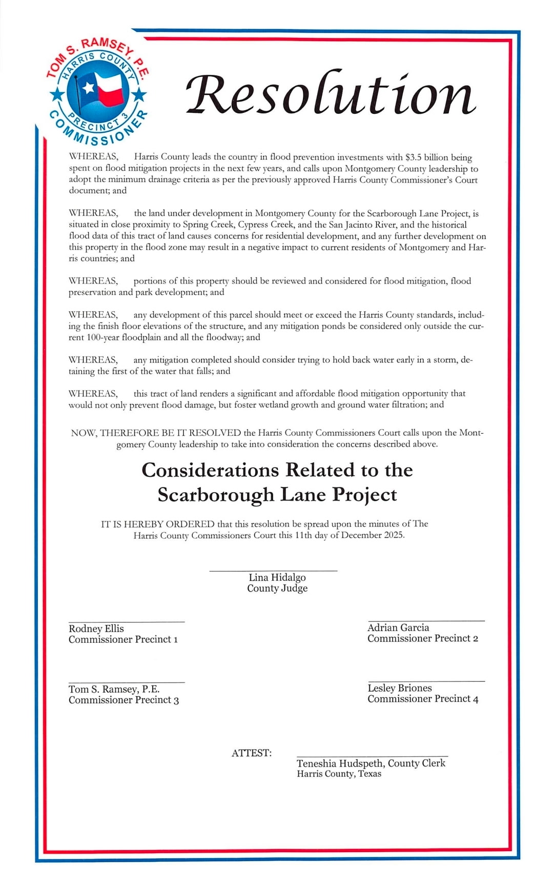
- Harris County unanimously approved a resolution urging Montgomery County to apply stricter Harris County floodplain standards to the development.
- Houston City Council unanimously approved a strongly worded resolution OPPOSING the Scarborough Development.
- Precinct 3 Commissioner Ritch Wheeler took an extension of Townsen Blvd off the 2025 Montgomery County Road Bond to make development more difficult.
- The Montgomery County Engineer is demanding an alternative evacuation route.
- Harris County will not permit a bridge across Spring Creek that the developer needs as an alternative evacuation route.
Even people who normally support Commissioner Dawn Buckingham are scratching their heads over this deal and the GLO’s concealment of information that should be public.
Posted by Bob Rehak on 1/6/2026
3052 Days since Hurricane Harvey
The thoughts expressed in this post represent opinions on matters of public concern and safety. They are protected by the First Amendment of the US Constitution and the Anti-SLAPP Statute of the Great State of Texas.


