The River Grove Park boat launch has finally reopened. Hurricane Harvey sanded it in two and half years ago.
These were among the first boaters at River Grove after the opening.Further downstream, the river was crowded with personal watercraft.Jet skis near Romerica property downstream from River Grove.South of Kingwood Country Club, I spotted four more boats.
Remember, River Grove is restricted to people with KSA stickers. River Grove is a private, not a public park. It’s restricted to Kingwood residents whose villages belong to KSA.
Hope you enjoy the great outdoors. The reopening of the boat launch has been a long time coming.
Just remember to be careful. There’s plenty of room for you and your boat out there on Lake Houston to practice social distancing…as you see in these photos.
Also remember that barges and dredges are still moving up and down the river. They can’t maneuver like you. So keep your distance.
Barges offloading spoils from mouth bar directly across river from River Grove Park.
Safety first, last and always.
Posted by Bob Rehak on 4/22/2020
967 Days after Hurricane Harvey
https://i0.wp.com/reduceflooding.com/wp-content/uploads/2020/04/20200421-RJR_1090.jpg?fit=1200%2C800&ssl=18001200adminadmin2020-04-22 21:06:302020-04-22 21:06:58River Grove Boat Launch Reopens
Ever since Harvey filled up the lagoon next to the River Grove boardwalk, Kingwood residents have clamored to restore the area. This week they got their wish. Kayden Industries has removed its two dredges and the giant “shaker” that separated sand from water. This morning, all that remained of the operation was a front-end loader, a giant pile of sand, and dump trucks rapidly carrying it away. They should be done with the operation this week.
Damage Due to Harvey
Here’s the story in pictures starting with Harvey.
The lagoon next to the popular boardwalk at Kingwood’s River Grove Park has totally filled in with sand deposited by Hurricane Harvey.Harvey also left a 10-foot high sandbar that blocked the drainage ditch that runs through River Grove.
Remove up to five feet of sand covering the parking lot and areas near the boardwalk
Restore soccer fields also covered in sand
Repave access roads and parking lots undermined by churning floodwaters
Inspect the boardwalk to ensure it was structurally sound.
Draw up a dredging plan for the lagoon with an engineer.
Identify a suitable place to put the spoils.
Bid the job.
Approve the plan and expenditure.
Note height of sand in River Grove parking lot relative to parking sign in background.
It was a monumental effort. Dee Price, KSA President and steward of River Grove Park, and Bruce Casto, KSA’s maintenance man, deserve kudos for spearheading the effort and saving this park.
Between Harvey and the end of 2019, vegetation had grown up over the sand deposited in the lagoon.Step one in the dredging: Remove the vegetation that had grown on the sand.Then, Kayden Industries mobilized a mini dredge. The dredging took seven weeks.
Drying the Spoils Before Trucking
Kayden also brought in this giant machine to separate sand from water. It works like an oilfield shaker used to separate drilling cuttings from drilling mud.
Last Week, Demobilization Began
Almost two months after it started, Kayden began demobilizing. Resident Josh Alberson captured the image below with his drone.
Last week, Kayden Industries started demobilizing their equipment. Here we see one of the two dredges getting ready for removal from the water. Kayden brought in a smaller dredge when the City lowered the level of the lake suddenly. The first dredge is up on blocks behind the pile of sand.Photo courtesy of Josh Alberson.This morning, where the shaker once stood, nothing but some sand remains.A giant pile of sand still blocks the boat dock.But dump trucks were lining up to receive the sand and carry it to a placement area in Humble out of the flood plain.The finished job: a beautifully restored lagoon, complete with some marshes to attract birds.
Water along the boardwalk is 3-5 feet deep, so don’t let kids play in it. That could be dangerous.
Some Repaving Left to Do
All the heavy traffic has taken a toll on park roads. “Everyone needs to understand that the paving problems on the road between the gate and the first stop sign were there long before we started trucking dirt,” said Dee Price, KSA President. “We have patched that area numerous times in the past.” Price said KSA needs to mill and re-pave that piece of road as the group did with the soccer road. Price plans to put that project in the next fiscal-year budget. But for now, she says, “We need to patch it again until we can do the major improvement next year.”
Posted by Bob Rehak on April 14, 2020 with thanks to Josh Alberson for the drone imagery
958 Days since Hurricane Harvey
https://i0.wp.com/reduceflooding.com/wp-content/uploads/2020/04/20200413-RJR_0511.jpg?fit=1200%2C800&ssl=18001200adminadmin2020-04-13 13:20:592024-03-12 18:38:56River Grove Dredging Done, Only Cleanup Left
Since Hurricane Harvey, KSA has worked diligently to restore the damage to River Grove Park. It has been a massive job. Harvey filled in the lagoon in front of the boardwalk; left five feet of sand in the parking lot, disc golf course, and playing fields; and deposited a sand bar more than a quarter mile long and 12 feet high in front of the boat dock.
River Grove Waterfront on 9/14/2017, two weeks after Harvey. Lagoon filled in, five feet of sand filled the parking lot, and a 1400-foot, 12-foot-high sandbar blocked off the drainage ditch that empties the western third of Kingwood.
Army Corps Restored River Access
The Army Corps cut a channel through the sand bar that blocked the drainage ditch that empties the western third of Kingwood. That was a huge sigh of relief for a large part of Kingwood. But much work remained to restore the park itself. Among the last items on the agenda: restoring the lagoon and boat ramp access.
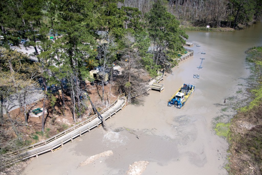
It’s hard to capture the scope of dredging operations from the ground – especially with access restricted for safety reasons. But last week, I did a flyover and captured these pics from a helicopter.
Looking west toward the River Grove Boat Ramp and Lagoon. Photo taken March 5, 2020. The dredge started by the boat dock and is working upstream now in the lagoon. Note the dewatering plant in the parking lot and the growing pile of spoils waiting for removal on the right.
In the photo above, you can see the 50-foot strip where Kayden removed vegetation. That will be the limit of dredging. KSA plans to remove 4-5 feet of sand from this area. The area still covered with grasses will remain wetlands. It will provide cover, habitat and food for birds and other species. That should help make River Grove a destination for birders again.
Harvey deposited sand several feet deep on the peninsula that defines the River Grove lagoon. That unfortunately killed many of the trees there. The wetlands remaining in the lagoon are now more important than ever. Eagles nest in the trees in the upper right of this photo on Romerica property.The dredge started in the area in front of the boat dock and is working its way upstream in the lagoon. Water from the dredge goes through a floating pipe to a dewatering plant in the parking lot. Water is then returned to the lake in a closed-loop process.
A Bit of the Oil Field Comes to River Grove
The dewatering plant separates sand and sediment from the water before returning the water to the river.This is the same type of equipment used in oilfields to separate drilling cuttings from drilling mud, before recycling the mud.
Expected Finish By End of March
KSA expects the dredging project to finish by the end of March, weather permitting. However, the boat ramp may not open immediately. The heavy equipment has damaged the asphalt in the parking lot. Repairs and restriping may take a few weeks more.
Originally, KSA expected to remove 10,000 cubic yards of sediment. The contractor now predicts they will remove 11,000 to12,000 cubic yards to complete the scope of work.
Other Park Improvements
The good news: When all of this is done, River Grove Park should be back and better than ever. During repairs, KSA decided to:
Convert several of the soccer fields from “league fields” to “public fields.” Residents have long requested that change.
Change the speed bumps to milder speed humps in the traffic circle. Boaters have long requested that.
Posted by Bob Rehak on 3/9/2020
923 Days since Hurricane Harvey
https://i0.wp.com/reduceflooding.com/wp-content/uploads/2020/03/20200306-RJR_9605.jpg?fit=1200%2C800&ssl=18001200adminadmin2020-03-09 15:54:072020-03-09 15:57:09New Aerial Photos of River Grove Park Show Extent of Dredging Project
River Grove dredging has finally begun. Silt and sand deposited by Hurricane Harvey 2.5 years ago is being removed from two areas: the boat launch and boardwalk. KSA obtained a final permit from the City of Houston and equipment arrived yesterday.
Boardwalk First Priority
As you can see from these pictures, the contractor wasted no time. Equipment has already started removing silt from in front of the boardwalk.
Mechanical dredging equipment excavates area near boardwalk.
Additional equipment is being staged from the parking lot.
Contractors closed off the parking lot adjacent to the boat launch for public safety.
Contractors have already started removing the top layer of vegetation adjacent to the boardwalkthat sprouted since Harvey.
Pictures From Immediately After Harvey
A huge sandbar deposited by Hurricane Harvey blocked the Kingwood Diversion Ditch which drains the western third of Kingwood.Note sand covering the parking lot. It was 5 feet deep in places.Taken 9/14/2017.
The lagoon in front of the boardwalk was badly silted in.Taken 9/14/2017.
Pictures Taken February 2020 Before Start of Dredging
Photo taken 2/13/2020 shows how vegetation grew up on silt in lagoon.Aerial photo of boat launch area taken on 1/20/2020 shows that Army Corps opened up the drainage channel to the river. However, the area near the boat launch remains too shallow for most boats to launch safely.
Dredging and cleanup should take about 6 weeks. Completion will make eager boaters and park visitors very happy. River Grove has long been one of the most popular parks in Kingwood.
Posted by Bob Rehak on 2/18/2020
903 Days after Hurricane Harvey
https://i0.wp.com/reduceflooding.com/wp-content/uploads/2020/02/IMG_0480-rotated.jpg?fit=1512%2C2016&ssl=120161512adminadmin2020-02-18 13:05:072020-02-18 13:06:01River Grove Dredging Begins
Yesterday’s second post about the wettest AND driest decade in our lifetimes helped explain something I’ve been puzzling about. Multiple mouth bars are forming around Lake Houston. The loss of tens of thousands of trees during the drought exposed soil. One massive storm after another then washed that soil toward the lake. Voila! Mouth bars.
Diversion Ditch Blockage
We already cleared the massive side bar that blocked the mouth of Kingwood’s diversion ditch.
The ditch (center left) that empties the entire western part of Kingwood at River Grove Park on the west fork of the San Jacinto was virtually closed off by this sandbar that formed during Harvey. An estimated 500+ homes above this point flooded.
West Fork Blockage
The Army Corps removed about a fifth of the West Fork mouth bar.
Army Corps at work removing a small portion of the West Fork Mouth Bar.Photo courtesy of BCAeronautics.
This is not surprising for a man-made lake that’s 65 years old. Dams have a tendency to hold back sediment. Sediment drops out of suspension where the moving waters in a ditch or stream slow down as they meet the still waters of a lake.
These mouth bars increase flood risk for everyone who lives near them. They form sediment damns that restrict the conveyance of the channels behind them. That forces water up and out of the channel into people’s living rooms.
Clearing the Way for Political Solutions
So how do we get rid of these mouth bars?
State Representative Dan Huberty is organizing another dredging program that should start soon. Primary targets will be the West and perhaps East Fork Mouth mouth bars. These smaller bars represent, believe it or not, a larger problem though. They fall into a jurisdictional quagmire. Does the water body they are on belong to adjacent property owners, the City, the County, or the State?
That will determine where the money for dredging comes from. And more importantly, whether the money that is already available can be used to attack the problem when a dredge is in the lake.
The bar is in an unincorporated section of Harris County. But the City owns the shoreline, and usually the first few hundred feet of channels.
Who will take ownership of problems like Walden’s? These details still need to be worked out.
HB1824 May Help
Ironically, HB1824, which I criticized because I believe it opens the door to river sand mining, may help in cases like Walden’s. The bill allows Harris County Flood Control to take sediment from the San Jacinto and its tributaries without obtaining a permit or paying a fee as long as HCFCD deposits the sediment on private land. (Remember: Lake Houston IS the San Jacinto River.)
I suspect the Walden ditch will become precedent for how such minor tributaries are treated. Walden’s nearness to the West Fork mouth bar would argue for making it part of any dredging program there.
A new year, new challenges!
Posted by Bob Rehak on 1/1/2020with photo and video from Jack and Greg Toole, and BCAeronautics.
855 Days since Hurricane Harvey and 104 since Imelda
https://i0.wp.com/reduceflooding.com/wp-content/uploads/2020/01/DJI_0032.jpg?fit=1200%2C675&ssl=16751200adminadmin2020-01-01 19:54:352020-01-01 20:20:31Multiple Mouth Bars Forming Around Lake Houston; Check out Walden’s
After a year of dredging, the Army Corps and its contractors are gone. Even though they didn’t get all of the West Fork Mouth Bar, they made dramatic conveyance improvements on the West Fork as these before/after photos show.
Sand Island Before Dredging
The first was a blockage that dredging contractors nicknamed “Sand Island.” It sat in the middle of the river just downstream from River Grove Park in Kingwood. According to the Corps, it blocked 90% of the river.
Sand Island formed during Hurricane Harvey. Boats that drew 18 inches of water could not navigate upstream past this giant sandbar.Photo taken 9/14/2019.
Sand Island After Dredging
Sand Island is now Gone Island.Photo taken 12/3/2019.
The Corps removed approximately 15 feet of sand over a 15 acre area that was 566.7 feet wide at its widest point. An acre is about the size of a football field. So this would be like stacking sand on a football field 225 feet high (15×15)! And that doesn’t even include the sand they removed from the channels on either side of the island in the background.
Sand Island Dredging Profile.
Diversion Ditch Bar Before Dredging
A second huge sand bar deposited by Harvey blocked the Kingwood Diversion Ditch, also at River Grove Park. The Diversion Ditch empties the western third of Kingwood. Approximately 600 homes flooded above this one blockage. They were in Barrington, Kingwood Cove, Trailwood, Kingwood Lakes and Kings Forest.
Diversion Ditch (center left) was virtually closed off by a new sandbar deposited by Harvey.Photo taken 9/14/2017.
Army Corps measurements show that at its highest point this bar measured 10 feet about the water surface. It forced water coming out of the ditch to make a 90 degree left turn where it then hit another downstream blockage.
Diversion Ditch Bar After Dredging
Photo taken 10/2/2019 after dredging opened up the channel and reduced the downstream bar.Photo of same area taken on 11/4/2019, but looking upstream.
The Corps dredged a channel 150 feet wide through this bar to a depth of 35 feet above sea level. That’s about 7.5 feet below the normal water surface elevation of the Lake. The channel narrowed to 50 feet wide where it meets the mouth of the ditch.
From the highest point on the bar to the target depth, the Corps removed 17.5 vertical feet of sand. From the mouth of the channel to the outer edge of the bar measured 750 feet.
Comparison in Satellite Images from Google Earth
Here’s how this section of the river looked from a satellite BEFORE dredging. The numbers refer to the discussions above.
Here’s how it looked AFTER. (Note this image was taken on 2/23/19 and the dredge was still removing sand island.
Altogether, the Corps removed approximately 2.3 million cubic yards of sediment. Even if the Corps didn’t finish the mouth bar, that’s a lot to be grateful for. Thank you, FEMA, Army Corps, Great Lakes Dredge and Dock and Callan Marine.
Have a merry Christmas!
Posted by Bob Rehak on 12/24/2019
847 Days after Hurricane Harvey
https://i0.wp.com/reduceflooding.com/wp-content/uploads/2019/12/BeforeAfter.jpg?fit=1200%2C1600&ssl=116001200adminadmin2019-12-24 11:44:182019-12-24 12:10:24San Jacinto West Fork Before-After Photos Show Dramatic Conveyance Improvements from Dredging
At its November meeting, the Kingwood Service Association (KSA) Parks Committee voted to dredge the boardwalk and boat ramp areas of River Grove Park. The work, when done, will finally restore the park to full function.
Harvey Nearly Destroyed Park
Hurricane Harvey nearly destroyed River Grove Park. Thanks to KSA, the park has made a remarkable comeback. Harvey deposited sand five feet high in the parking lot. It left a wall of sand 12 feet high and a quarter mile long that blocked the drainage ditch that runs through the park and empties the western third of Kingwood. In the process, it also blocked the park’s boat ramp, only one on the West Fork. Finally, the storm deposited sand in the lagoon by the boardwalk and across the southern end of the soccer fields.
By the time the park is fully restored, repairs will have taken more than two and a half years.
Boat Ramp After Harvey
The Army Corps spent weeks opening up the drainage ditch that contains the boat ramp. Contractors dredged a 250-foot wide opening in the bar. Here’s how that area looked then and now from a satellite and helicopter.
Google Earth image from October 2017 shows the massive sand bar blocking the boat ramp and drainage ditch that empties the western third of Kingwood.How the sandbar looked from a helicopter two weeks after Harvey.
Sand Bar After Dredging
Image from 2/2019.Boats can now get through the bar, but the area immediately in front of the boat ramp is still filled with sediment.Photo taken October 2, 2019.
Even though boats can get by the sand bar now, they can’t get in and out of the water. Sediment remains around the ramp area and must be dredged. The Corps dredge was too big to maneuver in the tight space around the dock.
The Corps asked KSA not to open its boat docks in the name of safety while dredgers were still working the West Fork. Now, with dredging done and all the dredge pipe removed, KSA can work on reopening the dock.
Lagoon Also Filled with Sediment
The lagoon opposite the boardwalk filled with sediment during Harvey, too. Here’s what it looked like two weeks after Harvey.
The lagoon next to the boardwalk totally filled in with sand deposited by Hurricane Harvey. Photo also taken two weeks after Harvey.
The Association has already located a placement area for the spoils far from the river and any flood plain.
If permitted, removal of the sediment around the dock and boardwalk would begin in January.
Removal should take 6-8 weeks. Sediment will be placed on the parking lot to drain and dry. Then it will be trucked to the placement area in Humble.
The park could be fully functional again as early as March next year.
Public Soccer Fields Now Available
While working to prepare this project, KSA also restored the soccer fields which had been covered with sand several feet thick. All fields are now playable and KSA has designated two as public fields.
All in all, it’s been a remarkable comeback for a park that Harvey all but destroyed.
Posted by Bob Rehak on 11/19/2019, with grateful thanks to Dee Price and KSA
812 Days since Hurricane Harvey
https://i0.wp.com/reduceflooding.com/wp-content/uploads/2019/11/RJR_4052.jpg?fit=1500%2C1000&ssl=110001500adminadmin2019-11-18 22:11:042019-11-18 22:54:25KSA Parks Committee Votes to Dredge River Grove Park Boat Ramp and Boardwalk
South of the River Grove Soccer Fields, Hurricane Harvey deposited several feet of sand. This is near the area where Romerica wants to build 25-50 story high rises and its marina for 640 40-foot boats.
00adminadmin2019-03-28 08:21:012019-03-26 20:27:20Photo of the Day #284
The boardwalk at Kingwood’s River Grove Park used to be a popular place for fishing, birdwatching and taking pictures of the family. Now the lagoon is filled in with sand.
00adminadmin2019-03-24 18:55:312019-03-23 18:58:15Photo of the Day #281
Romerica Investments, LLC has applied for a permit to develop wetlands, flood plain, and floodway in the area around Barrington and River Grove Park in Kingwood. Rumored for years, many residents, including me, assumed the project died after Harvey. After all, who would be crazy enough to build high-rises in the path of 250,000 cfs? But as they say in horror movies, “It’s baaaa-aaack.” The proposed development includes: a marina/resort district, a commercial district, a residential district, and roadway expansion.
Here’s a link to a video that describes the architect’s vision for the development. It was posted to Vimeo in February of this year. Note the sky-blue waters of the San Jacinto. (This is what you get when a developer in Mexico uses an architect in Rome.) See more specifics below.
Location of Romerica’s proposed development.
The major pieces of Romerica’s proposed Kingwood development. For details see below.
River and Floodway Alterations
The applicant proposes to construct a new navigation channel on the West Fork to the south of the proposed marina and expand the existing channel on the east for better connectivity between the proposed marina and the West Fork San Jacinto River.
Features of Proposed Resort District
The applicant proposes to develop the 25 acres north of the proposed marina into a resort district. The resort district will consist of a resort hotel, commercial, and residential space. The applicant proposes to construct:
Five towers within the resort district at a height of 90 feet for the western hotel parcel
Residential condominium towers at a height of 260 feet, and at a height of 500 feet (50 stories)for the eastern hotel and condominium parcel.
Fill material would be used to raise the elevation of the resort district 12 feet from 45 to 57 feet to raise the proposed structures above the Federal Emergency Management Agency (FEMA) 100-year floodplain of the West Fork San Jacinto River.
Features of Proposed Commercial District
In a 47 acre commercial district, the applicant proposes to construct:
Retail, residential, and office space.
Three towers ranging in height from 230 to 400 feet for the retail offices and residential condominium towers.
Additional mid-rise residential and retail spreads at a height of 70 feet.
Fill material would raise the elevation of the commercial district from 45 feet to 57 feet over base flood elevation and raise the proposed structures over the FEMA 100-year floodplain of the West Fork San Jacinto.
Parking garages with two below grade levels and concealed above grade levels to increase the footprint density.
A 19.25-acre lake (from an existing 16.25-acre lake) to create a smaller marina area for personal watercraft parking.
A 125-foot wide channel between the 80-acre marina and the 19.25-acre marina and the marina/resort district and the commercial district.
Features of Proposed Residential District
The 64-acre residential district would include:
Condominium structures, 65-feet high, on pier and beam foundations with elevated first floor parking and four stories.
They would use fill to elevate them to 58.5 feet, which is above the FEMA 100-year floodplain of the West Fork San Jacinto River.
25-story condominiums with parking garages.
Nearly 2 miles of 41 foot wide roadways with bridges over canals and streams.
Expansion of Woodland Hills Drive
The applicant also plans to bring in more than 1700 cubic yards of fill to raise and expand Woodland Hills Drive. Woodland Hills would become four lanes all the way to Hamblen.
Wetlands Mitigation: Somewhere Else
To compensate for all the fill they are bringing into the floodplain and wetlands, they would purchase mitigation credits from outside the Kingwood area. Basically this means that all of this development would be filling in local floodplains and floodway without commensurate local compensation. Said another way, it would constrict the flow of the West Fork during floods.
Comments are used to determine the need for a public hearing and to determine the overall public interest of the proposed activity. For accuracy and completeness of the record, all data in support of or in opposition to the proposed work should be submitted in writing. Concerns should contain sufficient detail to furnish a clear understanding of the reasons for support or opposition. Prior to the close of the public comment period on January 29, the Corps’ District Engineer will determine whether sufficient cause exists to hold a public hearing.
If no comments are received by that date, it will be considered that there are no objections.
Comments and requests for additional information should reference USACE file number, SWG-2016-00384, and should be submitted to:
Evaluation Branch, North Unit
Regulatory Division, CESWG-RD-E
U.S. Army Corps of Engineers
P.O. Box 1229
Galveston, Texas 77553-1229
409-766-3869 Phone
409-766-6301 Fax
swg_public_notice@usace.army.mil
Rehak’s Concerns
If not removed, the mouth bar will back flood water up into this area during major floods.
I thought Friendswood deed restrictions limited the height of commercial structures to 3 stories. When I built my commercial property, that was the limit. It was also a major point of contention during the construction of the new Emergency Hospital at 59 north of Kingwood Drive. I wonder how they’re getting around that. All these high rise buildings in the middle of a residential area will significantly change the character of the community. Most residents bought into Kingwood because of those deed restrictions.
Filling in our floodplain with mitigation credits purchased from somewhere else will significantly alter floodplain characteristics here. When KSA explored building a dog park in River Grove Park, the City engineer told us that the width of the fence posts could not reduce flood conveyance by .000001%. The maximum allowable was 0%.
Boat navigation on the West Fork has been if-fy for decades and getting worse due to sediment washed downstream from sand mines. Dredging may improve a two-mile stretch, but until the mouth bar is removed, boats will have a difficult time navigating beyond that. The Army Corps is having to dredge its way up and down the river. Any marina likely could not survive the kinds of floods we had in 2015, 2016 and 2017. Other structures would also likely be damaged.
If damaged in a future flood like Harvey, who would have pockets deep enough to repair these huge structures? Few would want to inhabit them. The one office building on Hamblen has flooded repeatedly in the 35 years I have lived here. It’s not just repairing water damage this close to the river; Harvey deposited 5 feet of sand in River Grove Park. How do you clean all of that sand out of a luxury resort?
The paving and filling of all this wetland will increase and accelerate runoff that endangers downstream properties.
It appears that no environmental impact study has been filed.
All of the floodplain calculations are based on old surveys which are currently being revised. Before these buildings could even be built, floodplain maps will be redrawn. Remember, USGS reclassified Harvey flooding at Highway 99 as a 42-year storm. The area where many of these buildings would be built has been under three feet of water at least four times this year.
I’m not an engineer, but will the soil support structures this large?
It already can take a half hour to get in and out of Kingwood at rush hour. This high density development could add thousands of additional cars when residents have indicated they do not want to widen Kingwood Drive or Hamblen Road. The information provided to date makes no mention of traffic loads.
Having said all that, the architects renderings look gorgeous. If they could solve those concerns, the development might be an asset to the community.
Please send your feelings, pro or con, to the address above.
These are my opinions on matters of public policy protected by the First Amendment of the U.S. Constitution and the Anti-SLAPP statutes of the great state of Texas.
Posted by Bob Rehak on 12/29/2018
487 Days since Hurricane Harvey
https://i0.wp.com/reduceflooding.com/wp-content/uploads/2018/12/Pieces-of-Romerica-Dev-e1546040851855.png?fit=1500%2C1095&ssl=110951500adminadmin2018-12-28 17:29:182019-01-13 12:39:04Public Notice: Army Corps and TCEQ Soliciting Comments on High-Rise Development Near River Grove Park