On Sunday morning, Jeff Miller, an Elm Grove resident who lives near Woodridge Village, reported 5.5 inches in his rain gage. That compares to a 6.24 inch rain that fell on Woodridge on May 7, 2019, when hundreds of homes in Elm Grove and North Kingwood Forest flooded. Also, Woodridge falls about 40% short of current Atlas-14 standards required to hold back floodwater from a 100-year storm.
Other important factors came into play last weekend that should relieve some of residents’ anxiety and help explain what happened.
First, remember that on May 7, 2019, Perry Homes’ contractors had clearcut 268 acres, but had barely begun work on detention ponds. Only one of five was complete.
Second, the intensity of the May 7, 2019 rain was higher than last weekend’s. On May 7, 6.24 inches fell in 5 hours. Last weekend, 5.5 inches fell in 9 hours.
Third, in 2019, the S2 detention area had been partially excavated but didn’t have any outflow control restrictions installed yet. So it didn’t really function as a detention pond.
Fourth, contractors had destroyed a berm between Elm Grove and Woodridge, and filled in a natural stream on Woodridge. Both have since been replaced.
I took the photos below Sunday morning between periodic sprinkles, several hours after heavy rain stopped. They show how the current Woodridge Village detention handled the storm. All ponds were well within their banks. One was empty.
The triangular pond on the left is N2. N1 is out of sight above it. The two ponds on the right are S1 (foreground) and S2 beyond it. N3 is out of sight at the top of the frame.
S2 was about halfway to two-thirds full.
The tail of S2 is already silting in but had plenty of room to spare.
N3 Pond on eastern edge of property was supposed to have had an outflow control device but never got one.
The Junction where water from all five ponds comes together before flowing into Taylor Gully. N3 is at top of frame.
Reverse angle shot of the Junction with Taylor Gully in the background. Note how high the detention ponds are compared to the gully.The areas that flooded so badly in 2019 are just beyond the ponds.
Water coming from the big trianglar N2 pond now has to go through these twin culverts which were almost completely inundated.
Wider shot shows volume of water backed up in N2.
Only N1 in the NW corner of Woodridge was totally dry. The outflow capacity is much greater than the inflow. So this pond provides no detention benefit whatsoever. Local resident Jeff Miller says he has NEVER seen standing water in this pond.
The thoughts expressed in this post represent opinions on matters of public concern and safety. They are protected by the First Amendment of the US Constitution and the Anti-SLAPP Statute of the Great State of Texas.
https://i0.wp.com/reduceflooding.com/wp-content/uploads/2022/01/20220109-DJI_0370-2.jpg?fit=1200%2C799&ssl=17991200adminadmin2022-01-11 16:46:412022-01-11 17:14:16Woodridge Village Detention Ponds Passed Sunday Test, But…
On December 17, 2020, Jason Webster and Kimberley Spurlock, lawyers for the plaintiffs in the 2019 Elm Grove lawsuits, added a ninth defendant in their eighth amended petition. The defendant is Storm Water Solutions, LLC at 16110 Hollister Street in Houston.
Complete List of Defendants
Defendants now include:
Developers:
Perry Homes, LLC
Figure Four Partners, LTD
PSWA, Inc.
Concourse Development, LLC
Contractors:
Rebel Contractors, Inc.
Double Oak Construction, Inc.
Texasite LLC
LJA Engineering, Inc.
Storm Water Solutions, LLC
Who Was Responsible for What and When
The eighth amended petition provides an overview of who allegedly did what and when, before Elm Grove flooded on May 7th and September 19th last year when water from Woodridge Village invaded Elm Grove and flooded up to 600 homes.
The developer defendants hired LJA, which had prepared the drainage plans for Woodridge Village, to prepare bid documents, plans and specifications, all of which required a stormwater pollution prevention plan (SWPPP) for all potential contractors. The developer defendants and LJA, through the municipal utility district, hired Rebel, Double Oak, and Texasite. Rebel and Double Oak then obtained the necessary permits for the SWPPP.
Bombshell Allegations
Here’s where it gets interesting. Sometime after that, the developers hired Storm Water Solutions to implement the SWPPP. However, they allegedly told Rebel and Double Oak that they did not have to comply with the specifications in the SWPPP.
The southern part of Woodridge Village on May 9 from a drone.Elm Grove is on left. Note lack of any perimeter sediment controls.Screen capture from Jim Zura video.
One day after the May 7th flood, the developers hired Concourse to inspect the detention ponds on the development. Plaintiffs allege that Concourse did not advise the developer defendants to makes any changes. The plaintiffs also contend that ALL defendants failed to comply with the SWPPP. The TCEQ cited both Rebel and Double Oak for violations of their permits after the May 7th flood for failure to install sediment controls.
The suit alleges that the developer defendants failed to supervise and ensure Storm Water Solutions complied with the SWPPP.
Twin culverts at the county line were severely constricted by sediment after the May 7th flood.Note lack of sediment controls such as gabions (wire baskets filled with rock).
Specific Allegations against Storm Water Solutions in Lawsuit
Storm Water Solutions website claims the company provides “complete storm water regulatory compliance to land developers, commercial and residential builders, general contractors, and utility districts.”
But in Count 10, Paragraph 76, the suit charges Storm Water Solutions with Negligence, Negligence Per Se and Gross Negligence for both the May and September floods. Specifically, the alleged negligence includes failing to:
Create an adequate storm water pollution prevention plan;
Implement a storm water pollution prevention plan;
Comply or follow the Storm Water Pollution Prevention Plan;
Install reinforced filter fabric fences around the Development;
Install adequate reinforced filter fabric fences around the Development;
Comply with Texas Pollutant Discharge Elimination System Construction General Permit No. TXR150000;
Supervise the Contractor Defendants’ compliance with the Storm Water Pollution Prevention Plan;
Enforce the provisions of the Storm Water Pollution Prevention Plan;
Enforce and/or implement the best management practices under the Storm Water Pollution Prevention Plan for the Development;
Implement the proper control measures on the Development;
Ensure a sedimentation basin was constructed at the Development;
Inspect the Development for failure to comply with the Storm Water Pollution Prevention Plan;
Modify the best management practices after the May 7, 2019 occurrence;
Comply with the plans and specifications for the Development;
Pay proper attention;
Provide notice or warning; and,
Coordinate activities and/or conduct.
It also alleges they allowed:
Storm water runoff into Plaintiffs’ properties;
Discharge of storm water from the Development.
Stormwater Pollution Prevention Plan Requirements, Objectives
Will supervise and implement good housekeeping programs, such as site cleanup and disposal of trash and debris, hazardous material management and disposal, vehicle and equipment maintenance, and so on?
Will conduct routine inspections of the site to ensure all BMPs are being implemented and maintained?
Will maintain the BMPs?
Is responsible for documenting changes to the SWPPP?
Is responsible for communicating changes in the SWPPP to people working on the site?
State of the S2 detention pond on May 9, 2019.
Plan objectives typically include:
Site stabilization ASAP
Protecting slopes and channels
Promoting infiltration of stormwater
Controlling the perimeter of the site
Protecting receiving waters adjacent to the site (Taylor Gully)
Following pollution prevention measures.
Minimizing the area and duration of exposed soils.
The southern part of Woodridge Village on May 9from the ground.
Posted by Bob Rehak on 12/25/2020with thanks to Jim Zura
1214 Days after Hurricane Harvey and 461 since Imelda
The thoughts expressed in this post represent opinions on matters of public concern and safety. They are protected by the First Amendment of the US Constitution and the Anti-SLAPP Statute of the Great State of Texas.
https://i0.wp.com/reduceflooding.com/wp-content/uploads/2019/05/NotWetlands.jpg?fit=1500%2C835&ssl=18351500adminadmin2020-12-25 16:47:582020-12-25 16:48:02Webster, Spurlock Add Storm Water Solutions to Lawsuit for Elm Grove Plaintiffs
Attorneys for owners of 304 flooded homes in Elm Grove have named Perry Homes, LLC and Concourse Development, LLC as additional defendants in their lawsuit. Plaintiff’s lawyers filed their 287-page, sixth amended petition on 6/16/2020. Today, they also filed a request for a new trial date of 3/1/2021.
New Information May Tie Perry, Concourse Directly to Floods
Based on allegations made in the lawsuit, it appears that attorneys may now have evidence that Concourse (the developer of Woodridge Forest) was also part owner of Woodridge Village. Wording within the allegations also suggests that Perry Homes was directly involved in the actions of its subsidiaries PSWA and Figure Four Partners, which in turn were telling contractors what to do and not to do.
This is potentially good news for plaintiffs because companies, such as PSWA and Figure Four are only subsidiaries of Perry. Such subsidiaries often act as shell companies that shield the parent company from liability. With few assets, the subsidiaries simply declare bankruptcy if they lose a large lawsuit. Then, life goes on as normal for the parent company. However…
Both Perry Homes and Concourse Development have substantial assets. Perry claims to be close to a billion dollar company.
Concourse developed the adjacent Woodridge Forest, where Perry also built homes. It bought Woodridge Village land and then held it for six days before selling it to Perry. Evidently, they didn’t sell their entire interest. Before the May 7th flood, Concourse bragged about its role in Woodridge Village. But after the flood, the company removed all mentions of Woodridge from its web site.
Screen Capture from Concourse Development website before lawsuits filed.
Allegations in Sixth Amended Petition
The big news: The plaintiff’s sixth amended petition now names Perry and Concourse as additional defendants. Previous petitions named only Perry subsidiaries, contractors and LJA Engineering.
In the new petition, defendants allege that:
LJA used an outdated version of Montgomery County’s Drainage Criteria manual when it designed drainage for Woodridge Village.
Figure Four failed to properly review the plans, catch the error, oversee LJA, or make construction decisions.
As a group, Figure Four, PSWA, Perry Homes and Concourse (referred to as “Developer Defendants” in the amended petition) hired contractors and directed them to fill in existing creeks and drainage channels, and to remove a levee or berm on the south side of Taylor Gully that had previously protected Elm Grove. The existence of this berm was not mentioned in LJA’s engineering plans, they say.
Even after the first flood on May 7th, when developers were aware of the danger, they failed to take corrective actions that would have prevented the September 19th flood.
As a direct consequence of their actions and inactions, the developers flooded hundreds of homes in Elm Grove.
The inactions of Perry and Concourse following the May 7th flood justify punitive damages.
Key Elements of Agreement Between Developers
The petition also claims that the four developer defendants entered into an agreement that called for them to:
Make exhaustive or continuous on-site inspections to check the quality and quantity of work
Be responsible for the techniques and sequences of construction, and safety precautions
Take responsibility AND liability for the contractors’ failure to construct the project in accordance with the contract documents.
However, the plaintiffs also accuse the developer defendants (through negligence or omissions) of:
Failing to make exhaustive or continuous on-site inspections to check the quality or quantity of the work
Failing to properly monitor the techniques and sequences of construction or the safety precautions to ensure Elm Grove would not flood during construction
Failing to ensure the contractors performed the construction work in accordance with the contract documents
Failing to incorporate drainage studies prior to initiating construction on the Development
Failing to properly direct and supervise the means, methods, and techniques of the sequence in which the contractors performed the work on the Development
Removing drainage from the Development
Removing a levee and/or berm from the Development
Failing to implement a proper construction schedule
Failing to follow the construction schedule
Blocking the drainage channels
Filling in existing drainage channels
Failing to properly install box culverts
Failing to create temporary drainage channels
Failing to allow adequate drainage after construction
Failing to install silt barriers
Allowing the Development to force rainfall toward Plaintiffs’ homes’
Diverting surface water towards Plaintiffs’ homes
Failing to pay proper attention
Failing to provide notice or warning
Failing to have a proper rain event action plan
Failing to have a proper storm water pollution prevention plan
Failing to follow a proper storm water pollution prevention plan
Failing to coordinate activities and/or conduct
Failing to supervise the activities of the Development and engineering
Failing to instruct in proper construction and/or drainage requirements
Failing to train in proper construction and/or drainage requirements
Failure to review engineering plans
Failing to comply with the Terracon Consultants, Inc. geotechnical report
Failing to construct the emergency release channel
Failing to timely implement the detention ponds
Allowing inadequate construction to take place
Failing to hire an adequate engineer to implement the project plan
Failing to protect runoff from flooding homes
Failing to protect Elm Grove from flooding during construction.
Basis for Exemplary Damage Claim
Paragraph 42 contains some of the strongest language in the complaint. It alleges that the Developer Defendants knew of the risks, and both the probability and magnitude of the potential harm to others. The complaint asserts, “These acts and omissions were more than momentary thoughtlessness, inadvertence, or error of judgment. Rather, the Developer Defendants had actual, subjective awareness of the risk involved, but nevertheless proceeded with conscious indifference to the rights, safety, or welfare of others.”
“Such acts and/or omissions,” the paragraph continues, “were a proximate cause of the flooding and the resulting injuries and damages sustained by Plaintiffs. Accordingly, Plaintiffs hereby seek an award of exemplary damages.”
Having said all that, the plaintiffs seek BOTH ordinary and exemplary damages (defined below).
Location of plaintiffs’ flooded homes in relation to Perry/Concourse property.
8 Defendants, 9 Counts, 2 Floods, 3 Degrees of Negligence
Altogether, the petition alleges nine counts against eight defendants in two floods. Spelling out who is being sued for what and why involves a lot of overlap and redundancy. But some of the Counts specify subsets of defendants, floods, allegations and degrees of negligence. So you may want to read the entire document.
The petition splits the defendants into three groups: Contractors, Developers, and LJA Engineering, with specific charges against each. The basis for charges sometimes varies also. For instance, charges against LJA include (in addition to many of those above) failure to:
Adequately report the modeling
Use the correct hydrology method
Adequately model the development
Notify the developers and contractors of the importance of the existing berm.
Plaintiffs say LJA was aware of the risks, but nevertheless proceeded with willful and conscious indifference to the rights safety and welfare of the victims.
As a result, plaintiffs are suing LJA for negligence, negligence per se and gross negligence for BOTH floods.
Differences Between Degrees of Negligence
Black’s Law Dictionary describes the differences:
Negligence is the failure to do something which a reasonable and prudent man would do, or doing something which a reasonable and prudent man would not do.
Negligence Per Se is the form of negligence that results from violation of a statute. The violation of a public duty enjoined by law for the protection of people and property. So palpably opposed to the dictates of common prudence that no careful person would be guilty of it.
Gross Negligence is the intentional failure to perform a manifest duty in reckless disregard of the consequences as affecting the life or property of another. It is a conscious and voluntary act of omission which is likely to result in grave injury when in the face of clear and present danger of which the defendant is aware.
Nuisance Claim
In addition to negligence, plaintiffs also claim nuisance…”When Defendants unlawfully diverted … water onto Plaintiffs’ homes.”
Black’s Law Dictionary defines nuisance as “…that activity which arises from unreasonable, unwarranted or unlawful use by a person of his own property, working obstruction or injury to right of another…and producing such material annoyance, inconvenience and discomfort that law will presume resulting damage.”
Seeking Damages, Exemplary/Punitive Damages
The ordinary damages, plaintiffs claim, consist of one or more of the following:
Cost of repairs to real property;
Cost of replacement or fair market value of personal property lost, damaged, or destroyed during such event;
Loss of use of real and personal property;
Diminution of market value of Plaintiffs’ properties;
Loss of income and business income;
Consequential costs incurred, inclusive of but not limited to alternative living conditions or accommodations and replacement costs;
Mental anguish and/or emotional distress;
Prejudgment interest;
Post judgment interest;
Attorneys’ fees
Costs of Court.
However, as a result of alleged gross negligence, plaintiffs also seek exemplary damages as punishment. Black’s Law Dictionary defines exemplary damages as “Damages on an increased scale awarded to a plaintiff over and above actual or ordinary damages, where wrong done to a plaintiff was aggravated by circumstances of violence, oppression, malice, fraud, or wanton and wicked conduct.”
Defendants’ Responses Not Yet Filed
As of this writing, the Harris County District Clerk’s website does not show responses filed by either Perry or Concourse to new allegations.
March 1 Preferential Trial Date Requested
Because of the number of plaintiffs, expert witnesses, defendants and law firms involved in this case, the plaintiffs have requested a “preferential trial setting” of March 1, 2021. A preferential trial setting eliminates the possibility of numerous continuances due to scheduling conflicts between the court, parties, attorneys and witnesses.
The plaintiffs have also requested a proposed Amended Docket Control Order that shows alternative dispute resolution (mediation) happening on 1/29/2021.
Net: If the judge accepts the new timetable, it will likely be another 7 to 8 months before this case sees any resolution.
As new developments happen, read about them here.
Posted by Bob Rehak on 6/19/2020
1025 Days since Hurricane Harveyand 274 since Imelda
https://i0.wp.com/reduceflooding.com/wp-content/uploads/2020/06/Location-of-Plaintiffs.jpg?fit=1200%2C871&ssl=18711200adminadmin2020-06-19 17:30:442020-06-19 17:33:39Elm Grove Lawsuit Names Perry, Concourse Development As New Defendants; Trial Delayed
LJA’s drainage design forces floodwater to make six turns within the space of about 200 yards. The areas at the left and top of the frame flooded during May and September last year when water overflowed.
Hints of Defense Strategy
However, in answering the allegations, LJA’s lawyers did hint at their defense strategy. In addition to their general denial, they claim that:
Plaintiffs’ damages were solely caused by the negligence of third parties over whom LJA has no control.
Plaintiffs did not hire LJA and therefore LJA owed no duty to the plaintiffs.
Intervening and superseding conduct on the part of third parties or other parties, persons or entities, acts as a total bar to plaintiffs’ claims.
The incident in question was an Act of God.
Here is their entire answer to the plaintiffs’ claims. LJA’s lawyers filed it with the Harris County District Clerk on 3/16/2020.
Opinions of Claims
Third parties in the case include several contractors, AND Figure Four Partners, a Perry Homes’ subsidiary of another subsidiary. Engineers, in my experience, often blame problems on contractors that didn’t follow plans. In this case, according to the drainage impact analysis submitted by LJA to Montgomery County, contractor(s) should have cleared only 30 acres on the northern portion of the site and 58 acres on the southern portion during Phase 1. See page 1, paragraph 2 of LJA’s Drainage Impact Analysis. However, Google Earth shows that about half of the 182-acre northern section and all of the 86-acre southern section were cleared by February 23, 2019. That was six weeks before the May 7th flood. Images taken of the northern portion of the site shortly after the May 7th flood show it was virtually clear except for piles of uprooted trees. Helicopter images show that substantially all of the northern section was cleared about the time of the Imelda flood. Construction documents also show that an engineer should have been supervising construction.
I’m not sure what they mean by “intervening” conduct. It sounds like interference from above. Hmmmm. Could they be pointing a finger at Perry Homes’ Figure Four Partners or Perry Homes itself? It will be interesting to see what happens with this one.
The District Clerk’s website shows no other activity on the case since LJA filed this document. Harris County Civil Courts will operate on a restricted schedule until further notice due to the corona virus. Hours of operation are from 7 a.m. to 6 p.m. Monday through Thursday. They are closed Friday through Sunday.
Judge Lauren Reeder months ago set a trial date of 7/13/2020, at 08:30 a.m. However, the corona virus could delay the start of any trial in this case.
New Discovery in MoCo Drainage Criteria Manual
In the meantime, I discovered one other interesting potential violation of the Montgomery County Drainage Criteria Manual. Section 9.1.2 Flood Plain Development Guidelines and Procedures says that when planning a development within the 100-year flood plain, construction within the floodway is limited to structures which will not obstruct the 100-year flood flowunless fully offsetting conveyance capacity is provided.
“Where such a potential exists, offsetting conveyance capacity must be provided to eliminate the increased potential for flood damage.”
The potential violation? The twin culverts shown in the photo above. They were built when only one of five detention ponds was even partially complete. And they’re right at the county line. LJA’s own maps show these culverts to be within feet of the Taylor Gully floodway and floodplain on the Harris County side of the county line.
If LJA intends to argue that May 7th or September 19th were greater-than-100-year rains, it then seems to me that they should have halted construction of the culverts until fully offsetting detention was in place. To this date, only 23% of the intended detention capacity has been constructed.
Posted by Bob Rehak on 3/28/2020
942 Days since Hurricane Harvey and 191 since Imelda
The thoughts expressed in this post represent opinions on matters of public concern and safety. They are protected by the First Amendment of the US Constitution and the Anti-SLAPP Statute of the Great State of Texas.
https://i0.wp.com/reduceflooding.com/wp-content/uploads/2020/03/20200306-RJR_0183.jpg?fit=1200%2C800&ssl=18001200adminadmin2020-03-28 20:14:022020-03-28 21:41:46LJA Denies Responsibility for Elm Grove Flooding; Says They Owed No Duty to Victims
LJA Engineers submitted a master drainage plan for the 2,200 acre Artavia development that Montgomery County approved. It has no detention ponds. And the drainage channels currently do not connect to the San Jacinto river. Even though LJA said they would connect to the river, the plans do not specify how, when or where. As you will see below.
Dead-end drainage. Currently, the Artavia drainage channel stops just short of the Liberty Materials Moorehead mine in the background. The San Jacinto River lies beyond the mine. This and all other aerial photos below were all taken March 6, 2020.
A Sand Mine Is Not the San Jacinto
The plans DO show the channel terminating in a sand mine between Artavia and the river. A spokesman for the sand mine said the developer is still trying to work out environmental and easement issues.
Aerial photos show the main channel stops about a 100+ yards short of LMI’s shipment facility. Meanwhile, during heavy rains, the dead-end drainage overflows onto surrounding properties. A spokesman for the mine claimed that the overflow flooded the mine last year and caused the dikes to break. He alleged that was the proximate cause for 56 million gallons of white sediment-laden water entering the West Fork.
Exhibit 2 of Artavia Drainage Impact Analysis from 9/20/2018 shows the project outfall in the middle of the LMI sandpit that borders Moorehead Road and the San Jacinto West Fork in Montgomery County.
The project manager for LJA did not return calls to explain their position on the dead-end drainage. And when asked for an explanation, the new Montgomery County Engineer (not the one who signed these plans) only referred me back to LJA.
Below are the drainage plans for Artavia, obtained by a Freedom of Information Act request to Montgomery County.
Several things have jumped out at me so far. LJA has not yet returned phone calls, so to me they remain…
Unaddressed Issues
Elevation Change Accelerates Flow
Elevation drops suddenly as you get near the river – 12 feet. That accelerates waterflow and threatens the sand mine. As you can see above and below, the channel is like a firehose aimed at the mine. That mine has enough problems of its own. In the past, dike breaches have affected Lake Houston water quality; we don’t need more of that. The mine blames the breaches on water overflowing from the Artavia ditch.
Note how the water in this short section of Artavia’s drainage ditch does not even pond at one end and reaches halfway up the banks at the other. That shows the slope. The SJR West Fork is between the two sections of the mine in background.
Flow Rates Understated
LJA calculations appear to understate the volume and velocity of flow. They use a Manning’s coefficient of .035, a value associated with pasture/farmland or channels filled with stones and cobbles. The coefficient recommended for smooth channels is 0.022. The difference creates a 63% increase in velocity and a 60% increase in volume of flow.See for yourself. With no real way yet for the water to get to the river or under FM1314, that will cause water to pile up much faster.
Not too many cobbles and boulders in this channel.All sand and siltwhich is already blocking culverts.
LJA also uses pre-Atlas rainfall statistics in their calculations of 10-, 25- and 100-year peak flows. The new Montgomery County standard is 16.1 inches in 24 hours compared to the 12.17 that LJA used for the 24 hour, 100-year flood.
Did LJA use “good engineering practices” and model Atlas 14 to ensure that it actually contained the 100-yr, 24-hr storm? There’s an ethical issue here. Did they put public safety first? We don’t know because they didn’t say so in any of their documents.
No Mention of Wetlands
LJA never mentions wetlands in their analysis. However, the National Wetlands Inventory shows wetlands on Artavia property and other property Artavia drains through.
Wetlands on Artavia Property or property Artavia drainage would likely have to go through.
Threat to Pipeline
A pipeline crosses the Liberty Materials mine. High velocity flow through the mine could undermine and threaten that pipeline like it did at another Liberty mine and at the Triple PG mine on the East Fork.
Green line shows path of pipeline across across Liberty Materials Mine. White line shows current path of drainage ditch.
No Outlet
There’s no explanation for how Artavia will get water through the pit at the end of their ditch. They can not store Artavia’s runoff in the pit. Their pit is already filled to the brim with highly silty, turbid water. Another unauthorized discharge could affect water quality in Lake Houston...again!
Level of water in the pit that Artavia’s ditch would have to drain through. Pit is already overflowing. West Fork is in background.TCEQ measured suspended solids in pit’s water at 25X higher than river.
Threat to Mine
A representative for the mine owner says the mine owner doesn’t want more water in the pit. They can’t afford the cost from environmental or business perspectives. With the COVID-19 threat, construction activity is way down. So margins are slim. And they can’t afford to have water fill their deep pit where they dry mine.
“No Adverse Impact”
LJA claims the project will have no adverse impact on downstream properties. But it already has. Properties along Greenbaugh and in Oak Tree have flooded since Artavia started clearing land and filling in wetlands.
Oak Tree detention pond (behind camera) used to overflow into wetlands. Then Artavia started clearing and filling. Now water backs up into the 40+ homes in the small subdivision.
The Liberty Materials mine also alleges it was flooded by Artavia’s overflow, resulting in the discharge of 56 million gallons of silty water into the West Fork.
LJA can only convey 68 cfs under FM1314. Meanwhile, TxDoT has not yet finished the design for a bridge. They hope to start bidding the job by the Fall of this year. Residents, not the developer, will pay for the improvement through the local municipal utility district.
Artavia ditch on north side of FM1314Where water exits on the downstream side of FM1314Channel downstream/south of FM1314.
LJA claims “The culvert crossings were designed to have capacity to convey 100-year storm events.” But they certainly aren’t doing that now.
Diverting Water From East to West Fork
The developer appears to be diverting water from the East Fork watershed to the West Fork watershed. See Section 1.4 and Exhibit One.
It would be harder to “beat the peak” to the East Fork. It’s 12 times farther away; water would take much longer to get there. So the diversion appears to be an attempt to avoid building detention ponds. But the diversion adds to flood volume in heavily populated West Fork areas where far more homes flooded during Hurricane Harvey.
Will LJA Figure It Out In Time?
For the sake of adjacent residents and businesses, let’s hope they figure these loose ends out before the next flood.
The thoughts expressed in this post represent opinions on matters of public concern and safety. They are protected by the First Amendment of the US Constitution and the Anti-SLAPP Statute of the Great State of Texas.
https://i0.wp.com/reduceflooding.com/wp-content/uploads/2020/03/20200306-RJR_9170.jpg?fit=1200%2C800&ssl=18001200adminadmin2020-03-20 20:48:012020-03-20 23:58:19The MoCo/LJA Way: Build First; Work Out Drainage Details Later
Mark Mooney, PE, the long-time Montgomery County Engineer whose office approved LJA plans for Woodridge Village and Artavia, and whose office oversaw LJA’s investigation of itself, has joined LJA Engineering as a “business development representative.” (Usually that means “sales.”)
A February 17, 2020, press release about Mr. Mooney’s appointment appears on LJA’s Facebook page. According to insiders, Mr. Mooney actually started working part time with LJA shortly after his retirement from MoCo. That happened after the May floods in 2019. However, the release now implies the relationship is full time. It appeared just days before LJA was named as an additional defendant in the Elm Grove flooding case. Below is the entire release verbatim:
MARK MOONEY, PE JOINS LJA AS BUSINESS DEVELOPMENT REPRESENTATIVE
After 34 years with Montgomery County, during which most of the time he served as the County Engineer, Mark Mooney, PE has joined LJA Engineering.
During his tenure, he had oversight of all major road initiatives through numerous bond elections; provided advice, direction, and consultation to 5 different County Judges and 17 different County Commissioners; oversaw the review and approval of over 3500 residential and commercial subdivision plats; oversaw the review, approval and inspection of over 1300 miles of road construction; and, provided daily services to a population that grew from 160,000 residents to over 600,000 residents in the 34-year span.
“I have known and respected Mark for many, many years. When the opportunity presented itself, I knew he was a perfect fit for LJA. We have four offices within Montgomery County and are personally and professionally vested in the growth and success of our employee-owners and clients there. Mark has dedicated his career to this community, and we want him to keep doing what he does best, serving Montgomery County,” said Jeff Cannon, Senior Vice President.
Mark was a Member of the City of Houston planning commission from February 1998 to May 2019. He is a Member of the Texas Association of County Engineers and Road Administrators (TACERA) since 1998; having served as President from 2005-2006, and he has been a Member of the National Association of County Engineers (NACE) since 1998.
Joining LJA, Mark explained, “It was the confidence that I felt between myself and Calvin Ladner (LJA President), that began when we were both a lot younger back in the mid-eighties, that sealed the deal. My responsibilities as the Montgomery County Engineer were made much easier by the honesty I had with Calvin initially and then with so many of the staff at LJA throughout the years. In my 34 years in this business, it always came down to trust as being the most important aspect as a public official. At LJA, I am ready to further develop my industry relationships utilizing the same playbook that worked for me for so many years as Montgomery County’s engineer.”
End of Release
Revolving Door Between Government and Business
[Rehak here again.] Before retirement, I frequently saw how the revolving door worked between government and business. I knew a man who went to Washington and worked for the EPA in a high level position “to get his ticket stamped.” Those were his words, not mine. After working in D.C. for several years, he returned to private industry where he made considerably more money, thanks to the insights he gave clients about how the EPA worked.
Personal connections provide knowledge of agency priorities; understanding of personal hot buttons; insights into procedures; and relationships with decision makers. They all prove valuable to companies whose sales depend on public-sector approval.
Fine Line Between Harmless and Harmful
There’s nothing illegal or immoral about this per se. On the innocent side, sometimes, if projects get bogged down, a call to an old friend can:
Move plans from the bottom of a pile to the top in an emergency.
Determine what the agency’s concerns about a set of plans might be so the concerns can be addressed quickly.
Speed up slow approval processes that run up costs.
Cases like these harm no one. They represent a form of social engineering or influence peddling that has been around as long as governments. However, what is normal and accepted in principle can sometimes turn sourin practice.
For instance, private-sector engineers/consultants might urge decision makers who are old friends on the government side to:
Rubber stamp questionable plans without looking too closely at them. (“Trust me.”)
Look only at the conclusion of a report without scrutinizing the assumptions, methodologies, underlying calculations and support.
Between these two extremes, between legal and illegal, infinite shades of gray exist.
Public’s Presumption of Oversight
Cases like those in the latter category can mislead the public and have devastating consequences. The public presumes the government is overseeing development (or at least the permitting of plans). In fact, government may not be. Those plans and stamps and dazzling arrays of figures may create the appearance of professional oversight when none exists.
Families may invest their life savings in homes based on the presumption of government oversight. Officials are supposed to ensure that there is no adverse downstream impact from a new development. But as we’ve seen in Elm Grove and elsewhere, that’s often not the case.
Bad Optics for Ethics
Exerting influence can sometimes cross moral, ethical and legal lines. I’m not saying it happened with Mr. Mooney. I have no evidence to even lead me to suspect such a thing. By all accounts, Mr. Mooney is honest and reputable.
Apparent Conflict of Interest In Elm Grove Investigation
However, it was on Mr. Mooney’s watch as County Engineer that the TCEQ referred a complaint about Woodridge Village involving LJA to Montgomery County for investigation.
To inspire public confidence in the outcome of the investigation, you would think that LJA would have recused itself or the county engineer would have hired another company for this particular investigation. Neither thing happened.
Certifying No Need for Detention Ponds in 2,200-Acre Development
Mooney’s department also vetted the LJA Drainage Impact Analysis for Artavia. It certified no detention ponds were necessary for the 2,200 acre development because it would have no impact on the West Fork San Jacinto. However, the report did not examine the impact on:
Surrounding homes whose drainage has been blocked
The impact on downstream flooding, i.e., loading Lake Houston before floodwaters arrive.
Approving Dead-End Drainage
Artavia’s Drainage Ditch stops before reaching the San Jacinto West Fork. The company hopes to work out some environmental and drainage easement issues that would allow the ditch to cross the LMI mine in the background.
LMI also blames Artavia’s alleged overflow for flooding a deep pit where they are doing dry mining. A large part of the pit remains flooded; disrupting LMI’s normal operations, according to a company spokesperson. (More on this in a future post.)
Supposedly dry pit that LMI says was flooded by Artavia drainage ditch overflow.
Meanwhile, Artavia is building homes and the developments drainage ditch still does not reach the river.
Certifying “No Adverse Impact” for Woodridge Village Right Before 400 Homes Flood
Under Mooney’s watch, county engineers certified that LJA plans would have no adverse impact on Elm Grove…right before 400 homes in Elm Grove flooded.
MoCo Engineers office certified “No adverse impact” for Elm Grove where hundreds of homes flooded twice in five months last year.
Accepting Job With LJA Right Before LJA Sued by Flooded Elm Grove Residents
The optics of these incidents sure don’t inspire trust and confidence in LJA, Mr. Mooney, or Montgomery County developers. In future posts I will dig into more of the details behind these incidents.
Calls to LJA’s project manager for Artavia went unanswered for days before this post. If LJA wishes to submit a response to this post, I will publish it verbatim.
Posted by Bob Rehak on 3/19/2020
934 Days after Hurricane Harvey
The thoughts expressed in this post represent opinions on matters of public concern and safety. They are protected by the First Amendment of the US Constitution and the Anti-SLAPP Statute of the Great State of Texas.
https://i0.wp.com/reduceflooding.com/wp-content/uploads/2019/05/Rescue-Truck-1.jpg?fit=1500%2C729&ssl=17291500adminadmin2020-03-19 21:02:222020-03-19 21:45:08Right Before LJA Sued, LJA Employs County Engineer Who Approved LJA Plans
Fourteen documents filed with the Harris County District Clerk’s office on February 27, 2020, lay out the case of plaintiffs in the Elm Grove flooding case against LJA Engineering, Inc. Lawyers for the plaintiffs named LJA as an additional defendant in their most recent amended petition. Other defendants include Perry Homes’ subsidiaries and contractors: Figure Four Partners, LTD.; PSWA, Inc.; Rebel Contractors, Inc. (which recently changed its name); Double Oak Construction Inc.; and Texasite LLC.
Accusations Specific to LJA
The amended petition alleges LJA:
a. Failed to follow the correct drainage guidelines in Montgomery County;
b. Failed to provide adequate drainage in the Development;
c. Failed to adequately model the Development;
d. Failed to adequately report the modeling;
e. Removed drainage channels;
f. Caused post-development discharges and water surface elevation to increase downstream of the Development;
g. Failed to design detention ponds with adequate capabilities for rain events;
h. Failed to use the correct hydrology method;
i. Failed to design emergency overflows for the detention ponds;
j. Failed to notify the Developer Defendants and Contractor Defendants of the importance of the existing levee; and,
k. May be liable in other ways described in the consulting engineer’s report.
Consulting Engineer Says LJA Used Outdated Drainage Criteria Manual
The defendants’ consulting engineer, L. David Givler, MSCE, PE, provides the details that back up these claims. Givler is president of Givler Engineering, Inc. Givler’s firm is licensed in Texas to design drainage projects similar to Woodridge Village, which was designed by LJA. A “Certificate of Merit” filed with the court states Givler’s credentials and conclusions. Givler also provides thirteen more exhibits as part of his affidavit. (See links at bottom of post.)
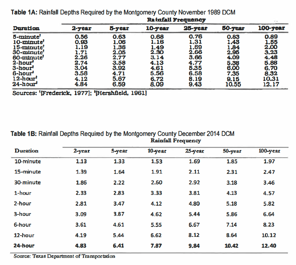
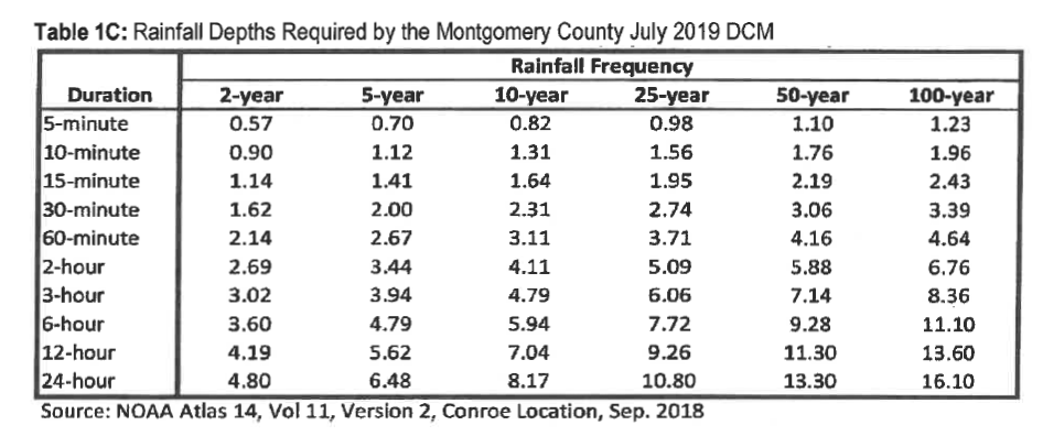
Perhaps Givler’s most explosive finding: LJA based all of its conclusions on an outdated version of the Montgomery County Drainage Criteria Manual (DCM) developed in 1989. MoCo has since updated its DCM twice – in December 2014 and July 2019. Givler asserts that LJA should have used the 2014 version when it submitted its drainage analysis in 2018. The rainfall that MoCo requires engineering firms to design detention basins for have increased since 1989 (see below).
Givler asserts that the increases, along with other other errors and omissions outlined below critically skew modeling results. Ponds that might not overflow based on the 1989 rainfall depths do overflow with 2014 and 2019 rainfall statistics.
Critical Levee Removed, But LJA Did Not Model Effect of That
Givler says in his testimony that grading associated with the construction project removed a levee that had been constructed along the south side of Taylor Gully. “Prior to being removed, the levee had successfully protected the Elm Grove Village Subdivision from flooding,” said Givler. “However, removal of the levee increased the probability for Taylor Gully to overflow southward and to flood the Elm Grove Village Subdivision.”
Givler asserts that the levee successfully protected Elm Grove from flooding in previous extreme events such as Hurricane Harvey, which he characterized as a 330-year storm.
LJA Did Not Use MoCo’s Recommended Method For Modeling Runoff
Mr. Givler also found that LJA did not use Montgomery County’s recommended method for modeling runoff. LJA used something called the Clark’s Unit Hydrograph Method instead of the NRCS Hydrograph Method specified in the 2014 version of the County’s Drainage Criteria Manual. The latter shows significantly higher peak runoff rates, according to Givler. “LJA’s selection of an alternative method (The Clark Method) caused the underestimation of peak runoff rates,” said Givler. “LJA also used low, outdated rainfall depths in its model, which exacerbated the underestimating of the peak runoff rates.”
Givler modeled whether LJA’s designs for the Woodridge Detention Ponds would have successfully held the runoff from the updated drainage criteria manual.
He found that the design for the ponds was “inadequate.” They overflowed. Significantly, Givler also found that LJA underestimated the volume of runoff sent downstream to Taylor Gully.
After May, Protection Not Implemented Against September Storm
“Even after the May 2019 flood, adequate measures had not been implemented to restore the pre-development level of protection or to prevent a recurrence,” said Givler. “Under Woodrige Village pre-development conditions, the Elm Grove Village subdivision was safe from flooding during the 330-year Hurricane Harvey rainfall. However, under construction conditions at Woodrige Village, Elm Grove Village was vulnerable to flooding in the 19-year and 92-year rainfall events.”
LJA Did Not Model Effect of Overflow Channel
Givler also noted that LJA’s plan claimed that the 100-year peak stage for the S2 detention pond would be 73.21. That would be high enough to cause water to backup into the grass-lined channel (bottom elevation 68.50) located at the northeast corner of the pond. “Since the highest adjoining ground elevation south and east of the grass-lined channel is approximately 72,” said Givler, “the peak 100-year stage would discharge to Taylor Gully downstream of the project and to the neighborhood east of pond S-2 [North Kingwood Forest]. Such discharges would increase flooding to the residential lots to the east…”
Figure 4 from Page 12 of Givler’s affidavit shows 100-year runoff overflowing Pond S-2 through the Grass-Lined Channel.The grass-lined overflow spillway in the center of this photo is designed to funnel water from Taylor Gulley into the kite-shaped detention pond (S2) if the concrete channel overflows. But Givler says LJA did not model the opposite. In May and September 2019, water flowed from the gulley into the homes at the bottom left of the frame, as well as homes opposite them on the far side of the gully.
Emergency Overflow System Not Provided
Another problem that Givler found: Section 7.3.13 of the Montgomery County Drainage Criteria Manual (2014 version) requires an emergency overflow system shall be provided “…designed to carry the 100-year allowable detention basin discharge at full-bank conditions… The emergency overflow system shall direct flows into an outfall channel and prevent flow in the direction of developed areas.” (as quoted by Givler).
Even today, the project does not include such an overflow system.
Runoff During Construction More Severe than Ultimate Buildout Conditions
Givler modeled actual construction conditions after the May storm. He found that “…with the project site cleared and stripped of vegetation, runoff conditions were more severe than even the ultimate buildout condition. LJA’s analysis does not address this condition,” he says. His analysis showed that under construction conditions, LJA’s partially-constructed detention ponds were inadequate, unable to contain the May 2019 runoff and the 100-year runoff.”
The temporary construction conditions he says, “caused the ponds to overflow and to discharge runoff to the Elm Grove Village subdivision at a peak rate of approximately 2,110 cubic feet per second.”
Water running through North Kingwood Forest into Elm Grove (background) during Imelda as Keith Stewart evacuates his family.
“LJA Failed to Act as a Reasonably Prudent Engineering Firm”
In his conclusions, Givler alleges that “LJA failed to act as a reasonably prudent engineering firm.” He added, “…three professional engineers and the engineering firm were negligent in the provision of professional services that they rendered, and they committed various actions, errors, or omissions in providing professional services by violating standards required by Montgomery County.”
In Givler’s opinion, LJA failed to comply with Montgomery County standards by:
a. Using an alternate (Clark) hydrology method rather than the NRCS method recommended by Montgomery County, resulting in the underestimation of the amount of runoff that the watershed would discharge to the detention ponds.
b. Using rainfall depths in the hydrology models which are smaller than what was required by the applicable county standard (2014 DCM) and that are much smaller than recently adopted values (2019 DCM).
c. Designing detention ponds, which are too small to contain and too small to detain or attenuate the 100-year design flood.
d. Failing to design adequate freeboard for the detention ponds.
e. Failing to design adequate emergency overflows for the detention ponds.
f. Designing a project, which diverts runoff to properties of others in a harmful and detrimental manner.
g. Allowing peak runoff discharges downstream of the project to increase due to the impact of the project and due to the limited effectiveness of the detention ponds.
h. Allowing water surface elevations downstream of the project to increase due to the impact of the project and due to the limited effectiveness of the detention ponds.
i. Erroneously representing that the project had no impact on downstream areas.
j. Failing to notify the contractor of the importance of the existing levee.
k. Failing to guide the contractor in a logical construction sequence that would reduce the flood risk during construction.
Violation of Professional Standards and Ethics Also Alleged
Mr. Givler also alleges that LJA and three of its employees violated standards established by the State of Texas and the Texas Board of Professional Engineers in the Texas Engineering Practice Act. “This negligence caused and/or contributed to the endangerment of lives, health, safety, property and welfare of hundreds of people near the project,” he says. They did this, he asserts, “by issuing misleading reports, which failed to indicate the increase in flood potential.”
Questions Remain
“I recognize that additional documents may be produced,” said Givler, “which I will be asked to review and, therefore, reserve the right to add to or to modify this affidavit based on information that may be provided to me at a later time.”
Except for general denials, neither LJA, nor any of the other defendants in this case have responded publicly yet to Givler’s specific allegations.
When LJA and the other defendants make their positions public, I shall review them and give them “equal time.”
The big questions I have at this time are:
Why would a firm with LJA’s substantial reputation make the blunders that Givler asserts? Were they pressured into producing a favorable report that made the economics of the project “work”?
Five previous developers owned this land and, after studying it, decided not to develop it. That certainly should have raised red flags for LJA and Perry, and caused them to review this closely. There must have been scuttlebutt circulating among local professionals. One engineer I consulted said Friendswood walked away from this property decades ago because it would have been too hard to develop. However, Perry decided to move forward based on dubious studies and incomplete data. Why?
Check out the original text of Mr. Givler’s affidavit and exhibits for yourself to ensure I summarized them fairly. His affidavit includes his findings, professional opinions, conclusions and Exhibit 1, his resume.
Exhibit 2 includes the list of documents Givler reviewed in developing his affidavit.
Exhibit 3 includes topographic mapping for construction and pre-construction conditions.
Exhibit 4 includes a topographic map showing the location of the former levee.
Exhibit 5 includes the approval letter by Montgomery County.
Exhibit 6 includes the rainfall values used by LJA.
Exhibit 8 includes reported locations of flooded properties.
Exhibit 9 includes the drainage impact analysis submitted by LJA on March 26, of 2018.
Exhibit 10 includes the drainage impact analysis submitted by LJA on August 28, of 2018.
Exhibit 11 includes Givler’s hydrology model for pre-development conditions.
Exhibit 12 includes Givler’s hydrology model for construction conditions.
Exhibit 13 includes Givler’s hydrology model for post-development conditions.
Exhibit 14 includes LJA’s design for detention pond S2, the one north of Village Springs.
Posted by Bob Rehak on March 8, 2020 based on testimony from David Givler PE
922 Days since Hurricane Harvey and 171 since Imelda
The thoughts expressed in this post represent opinions on matters of public concern and safety. They are protected by the First Amendment of the US Constitution and the Anti-SLAPP Statute of the Great State of Texas.
https://i0.wp.com/reduceflooding.com/wp-content/uploads/2019/10/Stewart-Evac-9.19.19-e1619020734162.jpg?fit=999%2C739&ssl=1739999adminadmin2020-03-08 14:18:022020-03-08 14:18:22Plaintiffs’ Engineer Alleges LJA Issued Misleading Studies, Followed Wrong Guidelines in Elm Grove Flooding Case
LJA also assumed that “sandy loam” covered the entire site when the National Resources Conservation Service soil database shows sandy loam covers only 60 percent. The Terracon report, however, never even mentions “sandy loam.”
Different Findings Could Have Skewed Runoff Analysis
Both the different characterizations of soils and their extent could have skewed the results of LJA’s runoff analysis.
LJA said the soil was “fine sandy loam,” everywhere, period. Terracon bored holes to 20 feet at four locations and found mostly clay-based soils. Terracon did, however, find “sandy silt” with “clay pockets” in the first foot of ONE of their borings.
That’s why NRCS clearly states that the infiltration rates above only apply to the first two inches of rain during an event. After that, the water may percolate down to another, less permeable layer of soil, such as the clay that Terracon found. At that point, fully saturated ground could force additional rainfall hitting the surface to pond or, if the land slopes, run off. That’s exactly what happened on May 7th and September 19th this year when Elm Grove flooded from Woodridge Village runoff.
But Terracon’s preliminary investigation sampled only four widely spaced spots at the perimeter of the property. None coincided with the locations of planned detention ponds, known wetlands, or streets. Only one even came close to a future home site. And the Montgomery County Engineer’s office has no record of Terracon performing additional work on the Woodridge site.
Also note that while NRCS shows sandy loam on 60% of the site, LJA assumes uniform distribution everywhere. That could also have skewed LJA’s computer modeling. NRCS showed that another 33% of the site (see below) contained soil consistent with wetlands. Wetlands don’t typically absorb water, often because of clay underlying them.
Wetland-Type Soils on ONE THIRD of Property “Overlooked”
SosA, Sorter-Tarkington complex, 0 1 percent slopes {Hydric, with inclusions that are non-hydric} and SouA, Sorter-Urban land complex, 0 to 1 percent slopes {Hydric, with inclusions that are non-hydric} comprise approximately 29% and 3.6% of the site respectively.
But LJA never mentions wetlands and the Terracon borehole sampling sites came nowhere near the wetlands on the property. Terracon spaced them widely around the perimeter as you can see from the site map with the red lines above.
Groundwater Levels Not Mentioned In LJA Drainage Analysis
Note the man-made rectangular pond in the upper right. It has been that full since it first appeared in Google Earth satellite images almost a year ago.That’s not a good sign for another area designated to hold a major detention pond (N3).
That means these ponds will never be able to achieve their promised detention capacities with their current dimensions. There just isn’t enough depth. Engineers measure detention capacity from the top of any standing water, not the bottom of the pond.
The first thing you notice about the Terracon report: the title says PRELIMINARY. Terracon also put “preliminary” at the top of every page. And repeated it 35 times within the report. Sometimes as many as three times in a single paragraph. Terracon also specifically recommended several followup tests. But if they were done, the Montgomery County Engineers office says it has no record of them.
Five Previous Developers Sold Site Rather than Develop It
At Thanksgiving Dinner yesterday, we had three engineers at the table. I posed the question, “Do you ever reach a point in projects when you say to yourself, “We shouldn’t do this,” as opposed to “How can we do this?”
The general consensus: There’s always a way to engineer a solution…if you don’t consider cost.
I wonder if that’s why five previous developers who owned this site didn’t do anything with it. They included Lennar, Kingwood 575, Reddy Partnership/Kingwood, Woodbridge 268, and Concourse Development.
It could be that they were just holding it and hoping to flip it at a higher price. Land generally appreciates faster than the rate of inflation. But it could also be that they investigated the cost of developing it more closely than Perry Homes did.
Below: the sales histories for the two major pieces of land that comprise Woodridge Village.
Of all the curiosities associated with this development, the sales history ranks near the top. Concourse held the property for less than a week before selling it to Perry Homes’ subsidiary, Figure Four Development LTD.
Perry Homes even commissioned and received Terracon’s Geotechnical report BEFORE Concourse bought the property. But that’s the subject for another post at another time. What was that about?
The important thing to note for now: When you’re selling dirt, it pays to know what kind of dirt you’re selling.
As Perry Homes Drags Out Court Case, It Could Incur More Liability
The once-proud Perry Homes is now buried under a mountain of law suits alleging that their actions flooded hundreds of homes…not once, but twice…in six months.
As Perry Homes drags these lawsuits out, Kathy Perry Britton could expose her father’s company to enough liability to bring it down. Can you imagine how a jury would react if Elm Grove flooded a third time when so many regulations have been flaunted? And when Perry has made no further attempt at mitigation since early August? I can.
Posted by Bob Rehak on 11/29/2019 with help from Jeff Miller
842 Days after Hurricane Harvey and 71 after Imelda
The thoughts expressed in this post represent opinions on matters of public concern and safety. They are protected by the First Amendment of the US Constitution and the Anti-SLAPP Statute of the Great State of Texas.
https://i0.wp.com/reduceflooding.com/wp-content/uploads/2019/11/Soil-Map.jpg?fit=1070%2C1500&ssl=115001070adminadmin2019-11-29 17:00:172019-11-29 18:13:20What Went Wrong, Part V: How Woodridge Village “Soiled” Perry Homes’ Reputation
Chapter 9 of the Montgomery County Drainage Criteria Manual discusses development in flood plains. Perry Homes and LJA Engineering somehow “overlooked” many of the points in this chapter. A flood plain ran through the property, but FEMA had not yet mapped it. LJA used that as an excuse to claim none existed.
Notice how flood plain mapping stops at county line. Perry Homes has the undeveloped property along and above the county line.Color code: Cross-hatched = floodway; aqua = hundred year flood plain; brown = 500-year flood plain.Source: MoCo Maps
Unfortunately, physical boundaries of flood plains do not observe political boundaries. Taylor Gully bisects this property, if you look at the flood maps, it magically defies flooding on the MoCo side of the county line.
Montgomery County Regulations Affecting Flood Plains
Below are guidelines from the Montgomery County Drainage Criteria Manual that Perry Homes would have had to follow had the property been mapped.
From Section 9.1.1 Floodplain Regulations:
“No fill or encroachment is permitted within the 100-year floodway which will impair its ability to discharge the 100-year peak flow rate except where the effect on flood heights has been fully offset by stream improvements.” [Emphasis added.]
“Placement of fill material within the floodplain requires a permit from the County Drainage Administrator. Appropriate fill compaction data and hydrologic and hydraulic data are required before a permit will be issued.”
From Section 9.1.2 Floodplain Development Guidelines and Procedures
“Construction within the floodway is limited to structures which will not obstruct the 100-year flood flow unless fully offsetting conveyance capacity is provided.”
“The existing designated 100-year floodplain and floodway should be plotted on a map of the proposed development.”
“The effect of the proposed development and the encroachment into the flood plain area should be incorporated into the hydraulic model and the resulting flood plain determined.”
“Careful consideration should be given to providing an accurate modeling of effective flow areas taking into account the expansion and contraction of the flow.”
“Once it has been determined that the proposed improvements adequately offset the encroachment, a revised floodway for the stream must be computed and delineated.”
From Section 9.2 Downstream Impact Analysis
“Pursuant to the official policy for Montgomery County, development will not be allowed in a manner which will increase the frequency or severity of flooding in areas that are currently subject to flooding or which will cause areas to flood which were not previously subject to flooding.”
What LJA Said About Perry Homes’ Project
On Page 1-2 of its Drainage Analysis, LJA Engineering explicitly states, “As shown on Exhibit 3, the proposed development is outside the 100-year floodplain.”
LJA Exhibit 3 shows the floodplain stopping at the county line. LJA also did its best to make the .2 percent risk area blend into the area of minimal flood risk. This visually minimizes the amount of floodplain bordering MoCo, so the abrupt stoppage at the county line becomes less visible.Source: LJA.
Ms. Mbewe then states in her conclusion, “Based on these findings, the proposed development of the 268-acre tract creates no adverse drainage impacts for events up to and including the 100-year event.” [Emphasis added.]
What Does “No Adverse Impact” Really Mean?
People often twist the definition of terms you think are self evident. Especially in legal, technical, and political contexts.
To me, “No Adverse Impact” should mean, “Downstream people who didn’t flood before won’t flood after development.” That’s what section 9.2 states explicitly.
But when I talked to a flood professional, I got a different answer. To that person, “no adverse impact” meant, “the amount of water flowing across the property did not increase after development.” Much narrower! And seemingly contradictory to the spirit of 9.2.
“Floodplain” Definition Shocked Me
But that person’s definition of floodplain really shocked me. To me, floodplain means “the area adjacent to a stream that fills with floodwater after a very heavy rain.” But the professional told me I was WRONG. To the professional, a floodplain was “an area on a map that FEMA designated a floodplain for insurance purposes.”
In that person’s mind, because FEMA had never mapped the area in question, a floodplain did NOT EXIST. Whether or not the area flooded!
To me, that’s like saying an apple is something you see in a Kroger’s flyer, not something you eat. We’re talking about the difference between a symbol of something and the reality of it.
This discussion proved once again that words and phrases have different meanings that depend on the social context of usage.
In the minimum compliance environment of Montgomery County, LJA and Perry Homes argued that there was no floodplain. They found someone in the county engineer’s office who agreed with them…or was told to agree with them.
FYI, the official FEMA definition says, “Any land area susceptible to being inundated by floodwaters from any source.”
Consequences of Overly Narrow Definition
So did Elm Grove flood because Perry Homes, LJA and Montgomery County did not enforce the floodplain regs in section 9.2 of the Drainage Criteria Manual?
They did not plot the REAL-WORLD floodway and floodplain on a map of the proposed development (see above).
LJA did not incorporate encroachment into the floodplain in its hydraulic modeling, because they denied a floodplain existed.
Neither did LJA provide “an accurate modeling of effective flow areas taking into account the expansion and contraction of the flow.”
Finally, LJA did not compute, revise and delineate the floodway for the stream.
Had they done all these things, perhaps people would have seen that downstream homes that had never flooded were now subject to greater flood risk. But that’s really something for the jury to decide. And it would require FEMA to model the floodplain after the fact.
But like the narrow definition of floodplain, this whole discussion symbolizes a bigger problem.
How Do You Fix a Permissive, Minimum-Compliance Environment?
Perry Homes could have demanded honest answers from its engineers, not the ones they wanted to hear.
FEMA could label areas like Woodridge Village “UNMAPPED”. This would send a signal to potential home buyers if sellers tell them they’re NOT in a floodplain. That might make developers think twice.
Home buyers need to demand integrity in this process. They need to ask better questions. They need to learn more about flooding.
But at the end of the day, Montgomery County Commissioners must define the kind of future they want. Do they want constant flooding? Or not. Because right now, they’re competing with other areas for new development on the basis of willful blindness and self-serving definitions.
Thirty years down the road, when it’s too late to fix the infrastructure problems they ignore today, MOCO residents will be paying the price. Some, who have flooded repeatedly, might argue they already are.
Posted by Bob Rehak on 8/26/2019 with help from Jeff Miller
820 Days after Harvey and 69 since Imelda
The thoughts expressed in this post represent opinions on matters of public concern and safety. They are protected by the First Amendment of the US Constitution and the Anti-SLAPP Statute of the Great State of Texas.
https://i0.wp.com/reduceflooding.com/wp-content/uploads/2019/11/HarrisMocoCountyLineFloodPlain.jpg?fit=1500%2C883&ssl=18831500adminadmin2019-11-26 20:52:182019-11-26 21:42:44What Went Wrong, Part IV: Perry Homes Develops Flood Plain That Wasn’t
Usually when you make an investment, the worst thing that could happen is that you lose all your principle. But Perry Homes could loose a hundred times more than they paid for Woodridge Village land. That takes special talent.
Out-of-Pocket Costs
The land that Woodridge Village sits on didn’t cost much; much of it was wetlands and many streams converged there. Regardless, a Perry Homes subsidiary, Figure Four Partners, bought the land. Montgomery County Appraisal District values the two main parcels at less than a million dollars. Together they comprise more than 80% of the 268-acre project. (See screen captures below from Montgomery County Appraisal District website.)
Real Costs Could Be 100X Greater
Now let’s look at the real costs to Perry. Just to screw up the land, they paid for:
Excavating two detention ponds (out of five they promised)
Soil tests and a geotechnical report
A mile of pavement to the middle of nowhere
Two large box culverts
Storm drains
Let’s say that cost another five million.
But all of that contributed to the flooding of approximately 200 homes in May and 350 in September. Let’s assume the damage to each home totaled $100,000. That comes to about $55,000,000.
Furniture, appliances, rugs, window coverings and other contents? Let’s assume an average of $40,000. That would total another $22,000,000.
Let’s also assume that 300 cars flooded. Average cost – $30,000. Bingo. $9 million.
Now let’s estimate the reduced marketability of homes that flooded. To do this, let’s assume an average price of $200,000 per home and a 20% reduction. That would cost homeowners $40,000 each in the market value of their homes. That’s another $22,000,000.
If juries rule in favor of the flood victims, that million dollar investment could add up to more than $100 million in potential liabilities…before any penalties for negligence and/or gross negligence kick in.
But perhaps Perry Homes went too far. People did notice. The wetlands that they conveniently ignored fall under the jurisdiction of the Army Corps. And the Corps is now investigating potential violations of Section 404 of the Clean Water Act. That could get expensive all by itself.
Like Building Homes at the End of a Gunnery Range
It just keeps getting worse for Perry. This was kind of like buying land to build homes at the end of a gunnery range. A little risky.
But it’s too late to rethink that decision. No one will ever want to buy a home on this site. It’s less marketable than swampland near Chernobyl.
There’s another rule of thumb in business. When you find yourself in a hole, stop digging. And that’s exactly what Perry has done. They have stopped work on the site for months. Work on detention ponds that would help protect people downstream from future flooding is going undone.
That means the numbers above could balloon with the next big rain. Or a negligence ruling by a jury. Yep, we’re in double Jeopardy now.
Career-Limiting Moves
Whoever made the decision to develop Woodridge Village definitely made a CLM (career-limiting move). At this point, even Perry Homes employees not associated with the decision must worry about their Christmas turkeys. Few careers or companies survive blunders that become case studies for how not to do something.
Eroding Profit Margins
Because of faulty assumptions and corner cutting, Perry Homes put itself between a rock and a hard place. They’ve managed to turn a million dollar investment into a potential $100 million liability. They can’t develop this property profitably now. And they can’t sell it. Who would want to buy this land and inherit the liability every time a storm cloud floats by?
To protect downstream homes from flooding, they would have to expand the detention ponds by at least 40%. And that would eliminate so many homesites that costs could exceed income. I say “at least” because the issue is not just Atlas-14 compliance. While digging the S2 detention pond, contractors hit water that’s not going away.
The S2 Detention Pond has lost about 20-30% of its capacity. The bottom 3-5 feet have been filled with ground watersince contractors started digging to the target depth.
That means they can’t achieve their detention goals by going deeper; they’ll have to go wider. And that will cut into marketable land even more.
Toxic for Perry Homes
Let’s face it. When Perry Homes bought this property, Kathy Perry Britton swallowed a poison pill. Woodridge Village now has a toxic reputation that will infect the rest of Perry Homes. No one will ever be able to trust anything Perry Homes says again.
But what to do with this land? If you’re Kathy Perry Britton trying to spit shine the legacy of dear old dad, you can’t keep it. And you can’t sell it. You can’t even give it away. No land conservancy organization would take it until the damage done to wetlands and streams was remediated. That could take decades.
The Real Value of Wetlands
However, there are two pieces of good news in this mess.
If Perry Homes implodes, it won’t take a lot of investors with it; the company is private.
Perry Homes may serve as a lesson to other developers and teach them that the real value of wetlands is their downstream legal costs.
Time To Be Decisive
Just remember, Ms. Britton. Historically, 85% of Houston floods are non-tropical. So if you think you have eight more months to figure this out, think again.
Posted by Bob Rehak on 11/15/2019
808 Days after Hurricane Harvey and 57 after Imelda
The thoughts expressed in this post represent opinions on matters of public concern and safety. They are protected by the First Amendment of the US Constitution and the Anti-SLAPP Statute of the Great State of Texas.
https://i0.wp.com/reduceflooding.com/wp-content/uploads/2019/11/RJR_4344.jpg?fit=1500%2C1000&ssl=110001500adminadmin2019-11-15 17:45:182019-11-16 09:51:58Perry Homes’ Woodridge Village Investment Could Be Costliest Ever