Harris County Flood Control District’s (HCFCD) work on Ben’s Branch has been one of the bright spots in flood mitigation since Hurricane Harvey. The channel is now wide open, bulldozers are neatening up the banks, and crews are hydromulching this morning.
What Is Hydromulch?
Hydromulch (or hydraulic mulch seeding, hydro-mulching, hydraseeding) is a planting process that uses a slurry of seed, mulch, and fertilizer. It is often used as an erosion control technique on construction sites, as an alternative to dry seed. The “gel” accelerates the growth of grass by providing enough moisture and nutrients for the seeds to germinate even in dry weather.
Progress Photos
Paul Campbell of Towncenter Apartments caught this shot outside his apartment this morning.
Hydromulching the banks of Ben’s Branch on 4/25/2020. Photo courtesy of Paul Campbell.Looking northwest over Ben’s Branch toward YMCA soccer fields (upper left). This and photos below taken 4/21/2020.Looking west up Ben’s Branch toward Kingwood Greens and Kingwood Country Club Forest Course across West Lake Houston Parkway.YMCA soccer fields in upper left.Reverse shot of the wide-open Ben’s Branch Channel looking east toward YMCA across West Lake Houston Parkway.
Hydromulching is usually the last step in channel repairs. Planting grass reduces erosion. Without it, rain would simply carry silt back into the channel.
Like New Again
Many thanks to the hard-working folks of the Harris County Flood Control district and their contractors.
In the last year, they have removed approximately 80,000 cubic yards of silt from the area between Kingwood Drive and the YMCA. Despite setbacks during Tropical Storm Imelda. Conveyance should now be restored to what it was in the mid-1990s.
Ben’s Branch hasn’t looked this good in decades. And residents will be much safer from flooding in future storms.
Posted by Bob Rehak on 4/25/2020 with thanks to Paul Campbelland HCFCD
Pop quiz: In the last 100 years in Harris County, Texas, were you more likely to get flooded in the first or second half of the year? And the answer is…second half. But surprisingly, it’s a close tie. Looking at the data, also revealed that a major flood happened every 2.5 years on average.
Harris County Flood Control District keeps a list of major floods. It actually goes back further than 1920. However, the pre-1920 records don’t reliably record the month of the flood, so I limited the sample to 100 years for the purpose of this quiz.
HCFCD shows 38 events through 2016. For my count, I added Hurricane Harvey (2017) and Tropical Storm Imelda (2019). Both happened since the last HCFCD chart update. And both produced major flooding in Harris County. That brought the total to 40 events.
22 of 40 Events Happened in Second Half of Year
Of the 40 major floods in 100 years, 18 happened from January through June; 22 from July through December.
That means you’re almost as likely to get flooded in the spring as you are by a tropical event in the summer or fall.
23 of 40 Events Happened During Hurricane Season
However, if you phrased the question as, “How many major floods happened during hurricane season?” you would get a slightly different answer. Seventeen of the 40 did not and 23 did.
That’s because:
June falls in BOTH spring and hurricane season. Note that two floods, Audrey in 1957 and Allison in 2001, both occurred in June.
In 1935 a major flood occurred during December, which is outside of hurricane season.
Major Flood Intervals Average 2.5 Years
The other major, mind-bending, slap-you-in-the-head statistic that comes out of this quiz concerns frequency. Forty events in 100 years represents a 40% chance of a major flood happening in any given year.
The average interval of major flood events: 2.5 years. The shortest interval: one month in 1929, 1989 and 2016. The longest interval: eight years between 1961 and 1969.
If those statistics don’t make you a believer in flood insurance, I don’t know what will. It should also make you a believer in flood control and drainage districts if you live in a southeast Texas county, such as Montgomery, that doesn’t have one.
Posted by Bob Rehak on 4/17/2020 based on HCFCD data
962 Days since Hurricane Harvey
https://i0.wp.com/reduceflooding.com/wp-content/uploads/2020/04/Flood-History-1200dpi.png?fit=1200%2C681&ssl=16811200adminadmin2020-04-17 13:46:202020-04-17 14:10:35Quiz: In Southeast Texas, Do Floods Happen More Often in First or Second Half of Year?
When I saw this meme, it made me realize that people feel walls closing in on them from the virus lockdown.
So take a quick getaway. Cruise down Ben’s Branch with Josh Alberson in his jet boat. Jetboats have a very shallow draft, so they can get into areas too shallow for propeller-driven boats.
First Video Shows HCFCD Excavation Work Up Close
Josh sent in two videos. One shows the area where Harris County flood control is currently excavating the last of almost 80,000 cubic yards of sediment. In this video, Josh’s boat moves slowly so as not to create wakes that endanger workers.
As he moves under the West Lake Houston Parkway Bridge, you can see an excavator stacking wet soil on the shore where it will drain before trucks haul it away.
Video courtesy of Josh Alberson
Said Beth Walters of Harris County Flood Control, “The material placed along the south bank of Ben’s Branch is drying out. It will be disposed of offsite. The south bank of the bayou will remain in the same location. This is a maintenance project to restore the channel.”
Second Video: High Speed to Lake Houston
The second video is more exciting. It makes you want to go out and buy a jet boat and explore the river and its tributaries.
As Josh moves past the YMCA and approaches the Deerwood Club, he pulls the throttles out all the way to Lake Houston.
Says Josh, “The Mouth Bar really extends all the way to shore. From the visible island to the park in the Cove, it is all only 2 ft or so deep. While Ben’s Branch may be up to 6 ft deep, it dumps out into a 2 ft deep flat.”
Video courtesy of Josh Alberson
But that’s City property and another project for another day.
Plans for Area South of Kingwood Drive
These videos do not show Ben’s Branch immediately south of Kingwood Drive to the Kingwood Library. Many readers ask about the aesthetics of that reach. Even though the construction has moved past that area, it still looks ragged.
Said Walters, “The contractor will be required to dress up the site so that turf grass establishment can occur. Contractors typically dress up the site and complete all final grading just before moving off site. Once dressed, HCFCD’s vegetation team will place turf grass placed upon it. The final condition of the entire project site will be as it was before, with turf grass on all of the earthen berms and banks.”
Posted by Bob Rehak on 4/8/2020with thanks to Josh Alberson, Beth Walters and HCFCD
953 Days since Hurricane Harvey
https://i0.wp.com/reduceflooding.com/wp-content/uploads/2020/04/Screen-Shot-2020-04-08-at-11.51.22-AM.png?fit=1200%2C676&ssl=16761200adminadmin2020-04-08 11:53:552020-04-08 12:12:52Getaway During Lockdown: Cruise Down Ben’s Branch in Josh Alberson’s Jet Boat
The SJRA announced earlier this week that the Harris County Flood Control District will partner with the River Authority on a “sediment trap” pilot study for the East and West Forks of the San Jacinto. The two have hired engineering firm Freese & Nichols to conceptually design the traps and identify the optimal locations for them.
Finding the Right Combination of Factors
Most sediment traps are big holes dug in a river or channel though some are off to the side. As water passes them, velocity decreases. Suspended sediment and sand being pushed along the river bed fall into them.
Source: EPA. The hole reduces water speed which accelerates deposition in a fixed location that’s easy to clean out.
The optimal length, for instance, depends on the speed of floodwaters and the settling rate of sediment particles. The trap needs to be long enough to give suspended sand time to fall out of suspension. Otherwise, sand just passes over the trap and continues downriver.
The hope: that the right type of traps placed in the right locations could help reduce flooding by reducing the amount of sediment migrating downriver and then blocking the mouths of each river branch.
Coming Out of HB1824 and River Basin Study
House Bill 1824, passed just last year, helps make sediment traps financially feasible. It allows the partners to remove material from the San Jacinto River and its tributaries to restore, maintain, or expand storm flow capacity without the need for state permitting or a royalty payment to the state.
The scope of work outlined for Freese & Nichols includes, but is not limited to:
Reviewing and comparing: current and historical LiDAR surveys and aerial photos to gauge sediment erosion, deposition and location
Evaluating digital elevation maps to identify constrictions
Identifying the ten areas with the largest volumes of sediment deposition, including the two largest at a sand mine.
Reviewing FEMA floodplain, National Wetland Inventory, Texas Historical Commission and Texas Parks and Wildlife information for any problems related to each potential site.
Core sampling of sand bars to determine silt content
Ranking preliminary locations using the following: sediment deposition volume, potential sediment storage volume, proximity to existing roads, proximity to existing APO facilities.
Selecting the four locations with the highest potential based on drainage area, sediment load, geology, road access, etc.
Narrowing that to three locations in conjunction with SJRA and HCFCD
Developing sediment trap conceptual solutions specific to each of the final three selected sites
Estimating rate of sediment accumulation and clean-out intervals
Estimating reduction of sediment accumulation due to trapping
Submitting a final report.
The project does NOT extend into Lake Houston. Freese & Nichols will examine both the East and West Forks plus three miles upstream from the East and West Forks along certain tributaries. Tributaries would include, for instance, Lake Creek and Caney Creek. The idea is to intercept sediment before it can make its way into the lake.
Project Timing
The project timetable indicates completion in early fall of 2020, about the same time as the entire San Jacinto River Basin Study. Thus, any recommendations coming out of this project would not be constructed for this hurricane season. SJRA currently hopes to have the trap(s) installed by the end of 2022.
Pros and Cons of Sediment Traps
Proponents say sediment traps can reduce expensive dredging, restore fish habitat, reduce flood risk and more. However…
The scientific literature on sediment traps reveals mixed reviews. Many efforts fail, primarily because of lack of maintenance budgets and regular clean-outs. The SJRA and HCFCD plan to address that issue upfront by involving the sand mining industry. Notice that of the four location-ranking criteria bolded above, three favor proximity to sand mines:
Sand mines have pits to store sediment.
They have roads that lead to the river that can carry heavy equipment.
Mines have cleaning, sorting and transportation facilities onsite to reduce transportation costs, and thus make material more attractive for resale.
Compensation for Sand Miners
A compensation agreement for sand miners who remove sediment from traps has not yet been worked out. However, Matt Barrett, SJRA’s project engineer, says, “The intended benefit to the APOs of participating in the public-private partnership would be that they could utilize or sell the material they remove from the trap(s). ”
River mining is outlawed in Europe, many other first-world nations, and even in some third world countries.
It tends to alter the gradient of rivers; cause upstream and downstream erosion; destroy private property along river banks; and undermine infrastructure such as bridges and pipelines.
Thus, the sediment traps raise a question of potential liability. If a pipeline or bridge is undermined or if property is eroded by the traps, who is responsible?
“Stability of the river is key to the long term safety and well-being of our community. We know that our public agencies have an important task. Before spending additional taxpayer dollars, don’t we want to make sure that projects won’t make problems worse AND won’t raise taxpayer costs?” said Jill Boullion, Executive Director of the Bayou Land Conservancy.
SJRA Response to Concerns
The SJRA has consistently denied that it would permit wholesale river mining. Most recently, Matt Barrett, the River Authority’s engineer for the sediment trap project said, “SJRA has no intention of engaging in or facilitating river mining in the San Jacinto River or any of its tributaries. The legislative language in HB1824 allows for the removal of material for the purpose of restoring, maintaining, or expanding the capacity to convey storm flows. Any projects undertaken by SJRA to remove or facilitate the removal of material from the San Jacinto River or its tributaries would be for this purpose.”
“River mining is not part of what we are doing. Only sediment in the trap will be removed,” he said.
Barrett is aware of potential hazards. “SJRA and its consultant are aware of the potential negative impacts that can be caused by trapping and removing sediment from a river or stream – changing the sediment balance – and prior to constructing any sediment trap or implementing removal of any material will perform analysis to ensure that any potential negative effects do not offset the positive.”
He sees the current design project as part of a pilot study that can scale up later. “One of the goals of this relatively small scale project is to serve as a “pilot” that gives us data on the real-world effectiveness of sand traps. If data indicates this is a viable flood risk mitigation solution, then additional funding and partnerships could be sought to expand the concept. We are excited to start this project and seek solutions to reduce flood risk.
For More Information
For more on how on sediment traps work, see this presentation found on the EPA site about a project in Michigan. It’s not directly analogous to south Texas because rainfall rates, soil types and gradients differ. But helps explain the theory of traps.
948 Days after Hurricane Harvey and 197 since Imelda
https://i0.wp.com/reduceflooding.com/wp-content/uploads/2020/04/How-Traps-Woirk.jpg?fit=1346%2C1058&ssl=110581346adminadmin2020-04-02 19:42:462020-04-03 16:21:37HCFCD Partners with SJRA on Sediment Trap Project
Harris County Precinct 4 Commissioner Jack Cagle has placed an item on next Tuesday’s Commissioners’ Court Meeting that will affect the future of Kingwood. It’s to discuss the possibility of Harris County Flood Control spending $10 million to buy the Perry Home’s Woodridge Village property. It contributed to flooding hundreds of homes in Elm Grove and North Kingwood Forest TWICE last year.
Where Will Two More Votes Come From?
Cagle needs at least two more votes on Commissioners Court in addition to his own to approve the effort. Reportedly, Judge Lina Hidalgo, Commissioner Adrian Garcia in Precinct 2 and Commissioner Steve Radack in Precinct 3 are the most “gettable.”
Here’s how you can help. Email or call these officials today. Urge them to support Cagle’s motion. Do it NOW. I’ve listed their contact info below.
At Stake: The Future of Kingwood
Ten flooded homes in a row, all vacated. Photo taken in North Kingwood Forest in December 2019. All homes back up to Woodridge Village.
Without help, Elm Grove and North Kingwood Forest could drag down the reputation of the entire Kingwood community.
Additional flooding could devastate remaining homeowners. Many were already struggling to pay repair bills from two floods. Now corona-virus layoffs make that even more difficult.
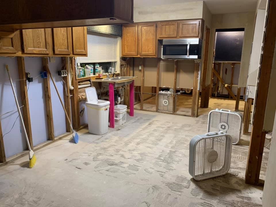
Elm Grove kitchen home five months after being flooded a second time.
These are working class neighborhoods. As much so as any in Harris County. People simply can’t afford to flood again.
Language in last year’s flood bond allows Harris County Flood Control District to buy property in neighboring counties for the purpose of building upstream detention. The lack of detention on Perry Homes’ property is the primary reason hundreds of homes in Kingwood flooded. Two years after clearing the property, Perry Homes still has constructed only 23% of the needed detention.
No Other Good Alternatives At This Time
Harris County Flood Control reportedly can start work on expanding detention capacity as soon as Commissioners reach a deal.
If they can’t, Perry has said it will sell Woodridge Village to another developer or continue to develop the property itself. However, if that happens, the detention ponds on the property would still likely be undersized by 40%. That’s because Perry Homes rushed to get their plans approved before the new, higher Atlas-14 rainfall standards went into effect.
Help Now! Here’s How
To contact Judge Hidalgo, Commissioner Garcia or Commissioner Radack:
Remind them that Harris County receives drainage from at least FIVE surrounding counties. This problem is a county-wide problem, not just a Precinct 4 problem.
Please call or write now if you live in the Kingwood, Huffman, Humble or Atascocita areas. Even if you did not flood, flooding from Woodridge Village affects you and your home value. No one in this area can afford to let this sore fester any longer.
Posted by Bob Rehak on 4/1/2020
946 Days after Hurricane Harveyand 195 since Imelda
https://i0.wp.com/reduceflooding.com/wp-content/uploads/2019/09/Elm-Grove-9.19_68.jpg?fit=1500%2C1000&ssl=110001500adminadmin2020-04-01 16:09:432020-04-01 18:46:07What You Can Do Right Now to Encourage HCFCD to Buy Woodridge Village Property
Starting tonight at 11:59 P.M. and lasting through April 3, 2020, “this Order requires all individuals anywhere in Harris County, to stay at home – except for certain Essential Activities and work to provide Essential Business and Essential Government services or perform essential infrastructure construction, including housing.”
Rustling Elms Bridge over Taylor Gully during peak of May 7, 2019 flood.
Non-essential and prohibited:
All exercise facilities including gyms, swimming pools and martial arts studios must close.
A broad range of retail shops must close including barbers, hair salons, tattoo parlors, bowling alleys, game rooms, massage parlors, malls, flea markets, movie theaters, concert halls and more.
All public and private gatherings occurring outside a single household or living unit are prohibited.
Nursing homes, retirement, and long-term care facilities must prohibit non-essential visitors except for end-of-life visitation or critical assistance.
Restaurants will remain closed except for drive-through and carry-out orders.
Churches may only provide services via video or teleconference.
Essential and still exempt:
Grocery stores
Pharmacies
Gas stations
Convenience stores
Liquor stores
Car dealers and repair facilities
Professional services, such as legal, accounting, insurance, etc.
Flood Control Not On List
The corona virus prohibited and exempted lists stretch for 20 pages. They are too numerous to summarize here. However, as I read through the list, nowhere did I see “flood control” or “flood mitigation” work. That made me wonder whether we had potentially traded one type of crisis for another.
So I reached out to county officials and asked how today’s corona virus order would affect the activities of the Flood Control District. Said another way, were they considered “essential activities.”
Flood Control Deemed Essential, Will Continue
The answer: Yes, Flood Control is considered essential under the infrastructure and construction provisions of the order. No, Harris County Flood Control District (HCFCD) will not shut down mitigation projects.
Matt Zeve, Deputy Executive Director of HCFCD had this to say. “Everyone who can will work from home. We had already been phasing that in before today. All construction and field work will continue as normal…with appropriate social distancing and hygiene procedures of course.”
Moving Into High-Risk Season for Flooding
As we move into April and May, the rainiest months of Spring, that’s comforting. A reader asked me today, “What would happen if we got a flood on top of the corona virus?” My first inclination was to tell her she needs to write the screenplay and go to Hollywood. But then I said, “That’s actually pretty plausible.”
People mucking out houses in unsanitary conditions and tight, crowded spaces could accelerate the spread of the virus. Crowded rescue boats and choppers would make a first responders nightmare, especially when rescuing people with the corona virus. Thousands of evacuees in churches, schools and convention centers. Evacuating high-risk populations like the elderly from nursing homes. These are not pleasant thoughts.
That’s why I’m glad that the work of flood control will continue as normal. Hurricane season is only nine weeks away.
Posted by Bob Rehak on 3/25/2020
939 Days since Hurricane Harvey and 188 since Imelda
https://i0.wp.com/reduceflooding.com/wp-content/uploads/2019/05/Taylor-Gully-at-Peak-e1728600738227.jpg?fit=1100%2C327&ssl=13271100adminadmin2020-03-24 20:14:102020-03-24 20:14:18Corona Virus Lockdown Expansion Will Not Affect Flood Mitigation
A flyover of the lower portion of Ben’s Branch on March 6, 2020, revealed that Harris County Flood Control has nearly restored its conveyance, even if some sediment still needs to be hauled off.
With most of lower Ben’s Branch cleaned out, the Kingwood Library (left), Kingwood Greens (right), and The Enclave (background) can now breathe much easier.
Among Hardest Hit Areas During Harvey
During Hurricane Harvey, some of the hardest hit areas in Kingwood bordered Ben’s Branch. Ben’s Branch cuts diagonally through Kingwood from St. Martha Catholic Church on the north to Town Center, Kingwood Greens, The Enclave, Kingwood Village Estates and Kings Harbor on the south. Post-Harvey surveys showed significant sediment buildup along the creek which reduced conveyance.
The project scoped by HCFCD is to remove approximately 80,000 cubic yards of sediment between the red line at Kingwood Drive and the YMCA at the bottom right of the circle.
Flood Control estimated they would need to remove 75,000 to 80,000 cubic yards to restore the conveyance. Despite a setback called Tropical Storm Imelda, the project has been moving along nicely.
Looking west from the West Lake Houston Parkway Bridge at Ben’s Branch before the project started.To get a sense of scale, that’s a HCFCD surveyor in the yellow jacket!The same area today (looking west from a helicopter over the WLHP Bridge (lower left).
Here’s how the rest of the project looks.
East of the WLHP Bridge (foreground), some sediment is still drying along the banks before removal.However, the channel is openagain for business.The long stretch behind the Kingwood Town Center Apartments has been restored.The stretch just south of Kingwood Drive by ReMax still needs clean-out and touch up.The area just east of the YMCA is still being actively excavated.Same area, still being actively excavated near YMCA.
Merchants and residents alike should breathe much easier during the upcoming hurricane season.
Posted by Bob Rehak on 3/10/2020
924 Days after Hurricane Harvey
https://i0.wp.com/reduceflooding.com/wp-content/uploads/2020/03/20200306-RJR_9648.jpg?fit=1200%2C800&ssl=18001200adminadmin2020-03-10 08:06:022020-03-10 12:36:35Conveyance of Lower Ben’s Branch Nearly Restored
Yesterday, a reader, Donna Hanna Dewhirst, sent me pictures of a dredging operation beginning in the channel that cuts through Walden on Lake Houston. Today, I photographed it from the air.
Walden Project Kicks Off
That’s the Walden Mouth Bar in the distance. So far, though, dredging activity has focused upstream near the country club.HCFCD classifies the project as a repair, though it is not yet listed on HCFCD’s repair page for this area.Photo by Donna Hannah Dewhirst.De-watering the spoils before transport. Photo by Donna Hannah Dewhirst.
Typically, in a project with wet dirt like this, contractors “de-water” it by letting it drain on the banks for a while. Once dry, they haul it away. HCFCD sent dirt from Ben’s Branch to a cleaning facility to ensure they weren’t transporting any dangerous bacteria or organisms living in the mud. From there, it’s reused in landscaping and other projects.
Reverse angle, looking upstream toward excavation in background on left.
Reader Jeff Bayless volunteered, “This is called Rogers Gully and drains a large part of Atascocita. This is actually the 2nd time they have removed sediment from this location. They finished the first round right before Imelda and lined the banks with riprap and fresh top soil further upstream all the way to Framingham Road. Had it looking good then Imelda hit and washed all their new soil back into the downstream parts by the County Club. This also made the mouthbar in the lake larger and shallower. My fear with the large mouthbar is if Atascocita gets a Kingwood May 7 type flash flood, the mouthbar will push drainage water into the homes along this gully. Hopefully the mouthbar removal is a real project that will happen before flooding occurs.”
Meanwhile, more channel repairs have started in Kingwood within the last few weeks. They consist primarily of erosion and outfall pipe repairs. Repairs are so numerous, HCFCD had to group them into a a series of smaller projects to expedite bidding and repairs. The project include:
G103-41-00-X008: Two damage sites (5622 and 5622A) consisting of slope erosion, toe line repair, and channel scour.
G103-38-00-X020: Three damage sites (5416, 5680, and 5682) consisting of bank sloughing and erosion repair.
G103-38-01-X014: A series of voids on the southern side of the channel. One void is very large and the concrete paving has begun buckling. Another void is above an outfall pipe that will need to be replaced. Access is limited and encroachments are present.
G103-38-00-X021: Slope erosion has progressed and will eventually begin to affect the concrete channel lining. Also, some sediment has built-up and needs to be removed.
G103-38-01-X010: One damage site consisting of slope erosion.
To see the locations of these channels, zoom waaaaay in on the map.
Posted by Bob Rehak on 2/13/2020 with photos from Donna Hannah Dewhirst
899 Days since Hurricane Harvey
https://i0.wp.com/reduceflooding.com/wp-content/uploads/2020/02/20200213-RJR_8133.jpg?fit=2048%2C1365&ssl=113652048adminadmin2020-02-13 19:09:192020-02-13 20:50:01HCFCD Launches Channel Repair Projects in Walden on Lake Houston and Kingwood
In 2018, Lake Houston area leaders identified a three-pronged strategy to help mitigate flooding. They dubbed it the “Plea for DDG.” Additional dredging, detention, and gates. Since then, dredging and gates have garnered the most media attention. Yesterday, however, we received some good news regarding additional upstream detention.
HCFCD Buys First Part of Raveneaux Club
The Harris County Flood Control District (HCFCD) closed on the purchase of the Raveneaux Country Club on January 30, 2020. The final purchase price for 27.63 acres of land was $11,496,427.20 which is also the current appraised value for the property.
Cypress Creek runs through the Raveneaux Club before joining Spring Creek and the West Fork of the San Jacinto upstream from Lake Houston.
The final deal includes a leaseback allowing the Country Club to continue operating for up to one year.
The Flood Control District will begin discussions with the Cypress Forest Public Utility District in February regarding an agreement to acquire the remaining 206 acres that primarily make up the golf course. HCFCD intends to use the land for a future flood risk reduction project in the Cypress Creek watershed.
Benefit to Cypress Creek AND Lake Houston Area
That project could help the Champion Forest area where hundreds of homes flooded during Harvey and other recent storms. It could also help the Lake Houston Area. By reducing and delaying floodwaters coming down Cypress and Spring Creeks, it could help offset releases from the Lake Conroe Dam.
The Flood Control District realizes that community interest in this matter is very high. At this time, project specifics have not been determined. The Flood Control District will have community engagement meetings to solicit input and ideas about the future project.
Some feel the loss of the Club could adversely impact surrounding home values. However, the Club had reportedly been losing close to a million dollars per year for several years and was no longer financially viable.
In a special web page devoted to the acquisition, HCFCD says it cannot predict how property values will change as a result of this proposed project. However, HCFCD “knows that properties with a lower risk of flooding have a higher value than properties with a high risk of flooding.”
First Part of a Larger Solution
It is unlikely that HCFCD will find one undeveloped tract of land large enough to reduce flooding in the Lake Houston Area by itself. Acquiring a combination of smaller tracts such as Raveneaux will likely be necessary. Yesterday, HCFCD took the first step toward a larger solution.
https://i0.wp.com/reduceflooding.com/wp-content/uploads/2020/01/Raveneaux-Location.jpg?fit=1200%2C817&ssl=18171200adminadmin2020-01-30 22:44:502020-01-30 22:58:01HCFCD Closes on First Upstream Detention Property
The project to remove approximately 76,285 cubic yards of sediment from the lower reaches of Ben’s Branch in Kingwood is nearing its goal.
High-Priority Ben’s Branch Project Began Last August
This was a high priority project for Harris County Flood Control District (HCFCD) not just because of the sedimentation, but because of the destruction it helped cause during Hurricane Harvey.
12 seniors from Kingwood Village Estates died either as a result injuries sustained during evacuation, or the stress of losing everything they owned.
Every home in the Enclave flooded: 283 out of 283.
All homes in Kingwood Greens flooded: 225 out of 225.
More than half the homes in Fosters Mill flooded: 346 out of 549.
The Kingwood Country Club flooded.
The Deerwood Club flooded.
100% of the businesses in Kingwood Town Center flooded.
100% of the businesses in Kings Harbor flooded.
Kingwood High School flooded to the second floor.
Kingwood’s library flooded.
Scope of project starts at red line on Kingwood Drive and curls south to the YMCA, where oval intersects West Lake Houston Parkway and blue line. Construction crews today were working on both sides of the West Lake Houston Parkway Bridge just above the Y.
The Ben’s Branch cleanup began last August, but suffered a setback during Tropical Storm Imelda. Much of the sediment that had been piled on the sides of the channel washed back into it during the storm.
Crews Making Up for Lost Time Since Imelda
Since then, however, Flood Control crews have been making up for lost time. Construction weather has been almost ideal. I took all the photos below on the afternoon of 1/7/2020.
Contractor pulls sediment from Ben’s Branch under the West Lake Houston Parkway Bridge.Just west of the WLHP Bridge, adjacent to Kingwood Greens in the background, another excavator was pulling sediment from Ben’s Branch and pushing it closer to shore……where yet another excavator was loading dump trucks. Contractors will remove an estimated 7,000 loads from the stream.On the East side of the WLHP bridge, two more excavators tag-teamed more sediment. While one worked the shoreline…Another broke up clumps of sediment and pulled it from the stream.The current downstream extent of work is just north of the YMCA. That bend in Ben’s Branch behind the excavator is the final bend in the project.
For More Information
HCFCD expected the Ben’s Branch project to take 9 months. That would put completion in April. At the current rate, the contractor should make that date and perhaps beat it.
For more information about the project, consult the Kingwood pages of the HCFCD website. The project ID is # G103-33-00-X004 – Bens Branch Conveyance Restoration.
All Kingwood residents will breath easier when HCFCD finishes Ben’s Branch.
Posted by Bob Rehak on 1/7/2020
861 Days since Hurricane Harvey and 110 since Imelda