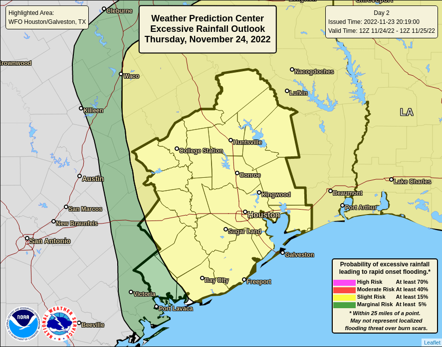
Tag Archive for: HCFCD

Powerful Thanksgiving Storms Could Bring Flooding

Rainfall predictions associated with approaching Thanksgiving storms keep increasing. Jeff Lindner, Harris County’s meteorologist now says approaching storms will bring widespread impacts from Thursday through Saturday. He also warns that heavy rainfall may lead to street flooding and rises on area creeks/bayous. Models now show a band of 5-7 inches of rain in places.

Thursday

Lindner says a surface warm front will approach the upper TX coast early Thursday and move inland. He expects showers to increase in coverage and intensity near the front, which may approach the US 59 corridor by midday before slowing and potentially stalling Thursday afternoon.

Along and south of the warm front be prepared for isolated severe storms and excessive rainfall with inflow off the Gulf. All the elements are in place for flash flooding “and warm fronts are notorious in these sort of setups for producing excessive rainfall,” says Lindner.

The best case for inland areas is that the warm front is held closer to the coast.

Friday – Saturday

Models have now slowed down the movement of an upper level low to our west. Lindner now predicts a break in the rainfall Friday morning, before another round of widespread, heavy rains move back into the area Friday afternoon and evening.

Expect grounds to become increasingly saturated and runoff to increase. Showers may linger into midday Saturday, before this system finally exits to the east.

Rainfall Amounts

Predicted rainfall associated with the Thanksgiving storms has increased compared to earlier forecasts. That’s because of the potential for slow moving and training thunderstorms Thursday afternoon and the longer duration of rainfall now expected into Friday and Saturday.

Widespread amounts of 1-3 inches can be expected on Thursday afternoon with isolated totals upwards of 5-6 inches.

Some models show a band of 5-7 inches near the warm front Thursday afternoon and this is concerning.

Hourly rainfall rates of 2-3 inches may be possible Thursday afternoon and this will lead to rapid street flooding and significant rises on creeks and bayous.

Jeff Lindner, Harris County Meteorologist

Additional rainfall amounts of 1-3 inches can be expected Friday/Saturday on top of what falls on Thursday and this will only worsen ongoing run-off from the Thursday rainfall.

Runoff 

Soils are primed for run-off with recent wetting rainfall over the region. Our main concern is street flooding, but Lindner cautions us about the potential for significant rises on area watersheds, especially if the higher totals are realized in portions of Harris County.

His greatest concern is for the southern and southeastern portions of Harris County where soils are the wettest and potential rainfall the highest. But he still isn’t confident enough to pinpoint the exact locations of the highest rainfall.

He says most watersheds can handle 3-4 inches. But if we start to exceed 5 inches, the concern for flooding from the bayous and creeks listed below will increase.

IF 5-7 inches, streams most in danger of flooding will be:

  • Clear Creek and its tributaries
  • Armand Bayou
  • Hunting Bayou
  • Halls Bayou (upper around I-45)
  • Little Cypress Creek
  • Willow Creek
  • South Mayde Creek (lower near Greenhouse)
  • Keegans Bayou (lower near Beltway 8/US 59/Wilcrest area)
  • Willow Waterhole
  • Brickhouse Gully
  • Spring Branch Creeks (Spring Branch, Buttermilk, Briar Branch)

Thursday’s Excessive Rainfall Potential

From National Weather Service

If you’re out and about over the holidays, remember. Be wary of underpasses and bridges. If you can’t see the roadway, you don’t know how deep the water is. Turn around and don’t drown.

Also remember. Seven inches was the amount of rain Woodridge Village received on May 7, 2019. Woodridge now has much more stormwater detention capacity. But there are plenty of other clearcut areas around the area that don’t have much if any yet.


Friday’s Excessive Rainfall Potential

From National Weather Service

Keep your eye on the sky if you head out the door this holiday. Don’t let the Thanksgiving storms ruin your holidays.

Posted by Bob Rehak on 11/23/22 based on a forecast by HCFCD

1912 Days since Hurricane Harvey

Five Watersheds Lose Population While Harris County Gains Slightly

Like damage, population is one of the “weighting factors” considered in the distribution of flood-mitigation dollars. Compared to 2017 estimates of watershed populations in Harris County, 2022 estimates show that five watersheds have lost population. But overall, the county has gained 155,254 people.

Data compiled from information provided by HCFCD in response to FOIA Requests. Alphabetical by watershed.

The map below shows the location of each of these watersheds.

Harris County Watersheds
Harris County Watersheds by Harris County Flood Control District

Reasons for Shifts Unclear

I had wondered whether the five major floods in Harris County between 2000 and 2020 (Allison, Tax Day, Memorial Day, Harvey and Imelda) would cause the most heavily flood-damaged areas to lose population. But that seems not to be the case.

The most heavily damaged watershed (Brays) lost the most population (in raw numbers). But the second most heavily damaged watershed (Greens) gained more than 16,000 people, the second largest gain.

I found no meaningful correlation between flood damage and population loss or growth. Nor do data suggest that flood-mitigation spending has much influence either. Contradictory examples abound. And statistical correlations rate as negligible to weak.

Five Watersheds Lost Population

Compared to the previous Census estimates from 2017:

  • Brays lost 5,822 people (0.8%)
  • Cedar lost 4,153 people (11.1%)
  • Hunting lost 1,112 people (1.4%)
  • Little Cypress lost 727 people (1.6%)
  • Vince lost 176 people (0.2%).

In percentages, Cedar Bayou lost the most population. Cedar was the sight of the Arkema disaster which blocked evacuation routes along Highway 90 during Harvey. The watershed currently has only about 37,000 people, ranking it 20th among the 23 watersheds in Harris County.

In five major storms between 2000 and today (Allison, Tax Day, Memorial Day, Harvey and Imelda), flood damage varied widely within those five watersheds:

  • Brays flooded 32,240 structures, the most of any watershed.
  • Cedar flooded 2,274.
  • Hunting flooded 15,763.
  • Little Cypress flooded 1,040.
  • Vince flooded 4,152.

18 Watersheds Gained Population

Eighteen other watersheds gained population and also had widely varying degrees of flood damage. These, too, showed little correlation.

Altogether, the county’s watersheds gained 155,254 people, despite 226,729 damaged structures during the five major storms.

Negligible Correlation of Flooding and Population Gain/Loss

The “population flees flooding” hypothesis didn’t hold much water.

Flood damage and “number of residents lost” correlated at only a 0.16 level – insignificant. Flood damage and “percent of residents lost” correlated at only 0.28, extremely weak.

A perfect correlation is 1.0. It indicates that for every unit of change in one variable, there is a corresponding unit of change in another variable. However, that was far from the case here. Variations seemed random.

If long-time Harris County residents are moving to higher ground, they may be replaced by newcomers unaware of flood risks.

The County has a strong draw: jobs. Also, family, friends, neighbors and support networks remain powerful attractions that keep most people anchored.

The new HCFCD data do not suggest why gains and losses occurred.

Top reasons for relocation typically include: greater safety, better schools, better housing, new jobs, and upgrading from apartments to homes.

LMI Population Trends

HCFCD also measures “LMI population.” LMI stands for Low-to-Moderate Income. The Census Bureau defines LMI as “families making less than the average for the region.”

Harris County has 42.6 % LMI residents. So 57.4% of residents make above the average for the region.

This is important because the LMI percentage plays a huge role in partnership grants from the US Department of Housing and Urban Development (HUD). Most, but not all, HUD grants go to areas with LMI populations higher than 70%. A notable exception is the pending $750 million HUD Harvey flood-mitigation grant. It only requires that 50% of the money benefits LMI households.

The latest HCFCD data shows that watersheds at both ends of the income spectrum lost LMI population. We still have the same eight LMI-majority watersheds we had in 2017. However, one deserves special mention.

Brays’ LMI population declined so significantly that it almost flipped from the “majority LMI” category to “majority upper income.” It went from 58% to 51% LMI.

Sixteen other watersheds gained LMI population. Some had huge flood losses; others had few.

The correlation between total flood damage and LMI Population Gain/Loss is .34, slightly higher than for the entire population but still considered “weak.”

Here are Harris County’s watersheds ranked in order of LMI population percentage.

As of 11/21/2022

My next post will discuss how the distribution of flood-mitigation funds relates to population changes and other factors. I will also discuss what the prospects for flood mitigation in the Lake Houston Area are during Lina Hidalgo’s second administration. Don’t miss it.

Posted by Bob Rehak on 11/21/22, based on data provided by HCFCD in response to a FOIA Request

1910 Days since Hurricane Harvey

The thoughts expressed in this post represent opinions on matters of public concern and safety. They are protected by the First Amendment of the US Constitution and the Anti-SLAPP Statute of the Great State of Texas.

Flood-Bond Update Shows Progress Slowing…Even More

Harris County Flood Control District’s latest flood-bond update shows that spending reported during the month of September slowed again. In:

  • July, monthly spending was $66.4 million.
  • August, monthly spending was $20.7 million.
  • September, monthly spending was only $8.1 million.

In September, HCFCD spent less than half of what it did in August and one-eighth of what it did in July.

All this comes at a time when many projects are wrapping up engineering and moving into the more expensive land-acquisition and construction phases. Also, construction has not been slowed by heavy rains; we’re still on the verge of drought. So the trend is opposite of what you would expect.

Spending by Watershed

The table below shows spending by watershed reported in the last two flood-bond updates. Note: The update presented to commissioners is delayed about six weeks. In the November 15th meeting, commissioners received the “October” update which actually showed bond spending through the end of September. Calculating the difference from the last two updates shows how much money HCFCD spent in each watershed during the last reported month (September).

Transcribed from maps in August and September 2022 Flood-Bond Updates.

This shows that five watersheds received NO money. And Luce received only $250. So, a quarter of the county’s 23 watersheds had virtually no activity.

In case you’re unfamiliar with the watersheds’ locations, see the map below from the Bond Update.

September 2022 Flood Bond Update
From HCFCD’s September 2022 Flood-Bond Update

Spending Decrease in Perspective

Let’s put $8 million into perspective. The recent “running rate” through July was more than $60 million per month. September is about 1/8th of that.

If $8 million per month becomes the new “running rate” – with $3.9 billion more to go – it would take another 40 years to complete all the projects in the bond. That’s in addition to the 4+ years we’ve already spent.

Harris County originally conceived the bond as a 10-year effort.

Other Indicators

“Spending to Date” is not the only indicator that things may be starting to come off the rails.

  • Construction contracts awarded somehow decreased from 48 to 40 even though the value increased from $393 million to $415 million.
  • HCFCD awarded 11 new “agreements” for a total of $11.6 million during the month, but the totals to date don’t add up with those reported the previous month.
  • Professional services invoices paid decreased from $4.8 million to $253 thousand – a 94% decrease.
  • Reported “overall progress” didn’t budge. It remained at 23.5% of the total bond.
  • “Key performance indicators” decreased again – this time from .97 to .95. This is a project management measure of on-schedule performance. Above 1 indicates “ahead of schedule.” Below 1 indicates “behind schedule.”
  • “Home buyouts in progress” decreased from 331 to 285. But HCFCD has spent only 31% of buyout funding secured to date. So there are many more to go.

For the complete update, click here.

Lake Houston Area

The San Jacinto watershed is the county’s largest. It received less than $50,000, but had the deepest flooding during Harvey. The only spending shown in the update for the San Jacinto is for “drainage system repairs” at an unspecified location.

The update shows no other active maintenance projects and no active capital-improvement projects in the entire Lake Houston Area.

The entire watershed’s percentage of all flood-bond spending for the month was 0.58%.

Why the Slowdown?

Several sources have indicated a variety of reasons:

Management Turnover – HCFCD lost its top three leaders recently: Russ Poppe, Matt Zeve, and Alan Black. These architects of the flood bond had decades of experience between them. They had conducted input sessions in each watershed, had a deep understanding of the issues, and were imbued with a sense of urgency.

Less Experienced Management – Two of the three have been replaced by an academic who formerly managed the Subsidence District and an administrator from Washington DC. Neither has direct Flood-Control experience. Reportedly, it takes them weeks to make decisions that used to be handled immediately. The Subsidence District has a budget one-thousandth the size of the 2018 flood bond. Can you say “apples and oranges?”

More Layers of Management – There’s now a whole new department – County Administration – between Flood Control and Commissioners Court.

Delays in Other Departments – As previously reported, Community Services has failed to submit a plan for how to spend $750 million allocated to Harris County for flood mitigation by the Texas General Land Office and the US Department of Housing and Urban Development.

Drawdown of Flood Resilience Trust Funds – Also as previously reported, the County is already running out of money in the Flood Resilience Trust Fund. This was designed to provide backstop funding to keep projects moving in case grants, such as the GLO/HUD funds, were delayed.

A Nightmare Scenario

Although Democrats on Commissioners Court previously reaffirmed their intent to develop all projects in the original flood bond, that was with a close election hanging over their heads. With the election behind them and a super-majority in hand, they can now do anything they want with impunity – including cancel projects in the Lake Houston Area to fund projects in other precincts.

It hasn’t happened yet, but given the history of recent money-grab attempts, as with Garcia’s attempted diversion of $191 million from Cedar Bayou, it could. Stay tuned.

Posted by Bob Rehak on 11/16/22

1906 Days since Hurricane Harvey

The thoughts expressed in this post represent opinions on matters of public concern and safety. They are protected by the First Amendment of the US Constitution and the Anti-SLAPP Statute of the Great State of Texas.

So Far, Early Voting Turnout Dismal

Early voting turnout this year rates a D for “dismal.” At the close of polls on Wednesday 11/2/22, only 566,006 of the 2.57 million registered voters in Harris County had voted. That’s 22% with just Thursday and Friday left for early voting. By comparison, during the 2018 mid-terms (the last comparable election), 63% of Harris County voters voted early. With two days left in early voting, we can make up some ground, but not that much.

Kingwood Slightly Better than Rest of Harris County

The nightly totals show that the Kingwood Community Center has had the fourth highest turnout in Harris County so far this year.

Yet Kingwood has had only 14,000 residents vote out of the 44,000 registered in 77339 and 77345. That’s 31.8 percent so far, and much better than this year’s county-wide average of 22%. However, Kingwood’s 31.8% is still only half of the county’s 63% early-voting rate in the 2018 mid-terms.

Total 2018 Turnout Doubled Countywide Turnout to Date

During all 13 days of voting in the 2018 mid-terms (early and Election Day), 1,219,871 voted compared to 566,006 so far this year. So, 2018 turnout more than doubled turnout to date in this election.

To equal 2018 turnout, we need as many people to vote in the three days left as have already voted in the last ten!

And don’t think we’ll make it all up on Election Day. In the last mid-term, almost 63% of those who voted voted early.

So far this year, we’re about 250,000 votes short of 2018 early-voting totals. We only have two days of early voting left and the County is averaging a little more than 50,000 votes per day so far. So, even if we get another 100,000 in the last two days, we’ll still be about 150,000 early votes short of 2018.

To put that in perspective, Ed Emmett lost to Lina Hidalgo in 2018 by 20,000 votes county wide. And 30,000 people have yet to vote in Kingwood alone.

And that doesn’t even include Huffman, Spring, Humble, Atascocita, or Crosby.

A Chance to Regain Fairness on Commissioners Court

If you vote in one race in this election, vote for Republican Alexandra Mealer instead of Lina Hidalgo. Mealer offers a chance to get better balance on Commissioners Court and some measure of fairness in flood-mitigation expenditures. Right now, Democrats have a 3-2 majority and consistently vote as a block in favor of their own constituents.

Since Harvey, Harris County has spent $1.6 billion on flood mitigation projects. As of today, Harris County Flood Control District shows $234 million in capital improvement construction projects underway. NOT ONE is in the Lake Houston Area. Of the 20 active projects, 18 have gone to Democrat Commissioners Garcia and Ellis. The two Republican-leaning precincts have one each.

Screen capture from HCFCD.

Yet we had the highest flooding in the county during Harvey.

worst first
Chart showing feet above flood stage of 33 gages of misc. bayous in Harris County during Harvey.

And we’ve been one of the most heavily flood-damaged areas in Harris County dating back more than 40 years.

From MAAPnext.org. Cumulative flood losses since 1979.

Yet under Hidalgo all the money goes elsewhere in the name of “worst first.”

To All Who Flooded – Three More Days Left

Ten days of voting are behind us. Three are left: the rest of today, Friday and next Tuesday.

Get out the vote, folks! Walk your block. Knock on doors. Forward this link to everyone you know. And remember this dismal turnout the next time you flood. This election is the best chance you have to reduce flood risk to your family and property.

The Mealer/Hidalgo County Judge race is buried halfway down the ballot in the middle of judicial races – between family and civil court judges.

While you’re at it, remember the three county bond issues totaling $1.2 billion also on the ballot. And remember that the Dems already voted to distribute this money unequally, favoring Precincts One and Two by a wide margin. But you won’t see that on the ballot language. So much for transparency!

To find your sample ballot and the nearest voting location, go to HarrisVotes.com.

Yes, you will have to wait in line. But while you’re waiting, remember how long you’ve waited for flood mitigation help that has yet to arrive!

Looking east from the south side of the West Fork of the San Jacinto during Harvey

Posted on Bob Rehak on 11/3/22

1892 Days since Hurricane Harvey

The thoughts expressed in this post represent opinions on matters of public concern and safety. They are protected by the First Amendment of the US Constitution and the Anti-SLAPP Statute of the Great State of Texas.

All You Need to Know About Flooding Before You Vote

Before you vote this year, review these two graphs and a map. They should tell you everything you need to know about flooding and flood mitigation in the Lake Houston Area. They should also motivate you to vote if you are on the sidelines.

Highest Flooding

The first graph shows “feet above flood stage” during Hurricane Harvey at numerous gages on different watersheds around Harris county. It shows how high floodwater got AFTER it came “out of banks.”

The San Jacinto West Fork at US59 had THE highest flooding in Harris County during Harvey.

Lowest Funding

The second shows the amount of flood-mitigation dollars spent in each Harris County watershed on right-of-way acquisition and construction for flood-mitigation in the first half of this year. Those activities help mitigate flooding as opposed to studies which frequently never get acted upon.

The reversal is stunning.

Data obtained via FOIA Request. San Jacinto, the county’s largest watershed, received only $200,000. Only Cedar Bayou received less at $160,000.

Worst Last

The San Jacinto Watershed moves from the high side of the flooding graph to the low side of the funding graph.

But why the first six months of this year? I’ve talked ad nauseam about spending trends going back decades. This window shows us current priorities. Especially during an election year when you would think the County Judge would try to appeal to as many people as possible.

Regardless of how you feel about the equity prioritization framework, you would think that in a ten-year bond program, areas like Lake Houston would start seeing some real benefit by now. Narrowing down the range of spending helps provide better insight into the priorities of County Judge Lina Hidalgo. She’s the deciding vote on Commissioners Court.

How to Punish The Opposition

People are saying, “OK, I’ve waited patiently. When will I see some benefit from the 2018 flood bond?” That was more than four years ago already.

Unfortunately, the answer is “no time soon.” The map below shows current active Flood-Control capital-improvement construction projects and how the three Democrats on Commissioners Court have used their majority to punish Republican-leaning areas.

Maintenance projects are shown in orange. And capital-improvement projects appear purple.

Flood Control has 20 active construction projects in the capital-improvement category. Of those:

  • Republican Jack Cagle’s Precinct 4 has one.
  • Republican Tom Ramsey’s Precinct 3 has one.
  • Democrats Rodney Ellis and Adrian Garcia split the other 18 among themselves.
  • Not one is in Lake Houston Area.

And Judge Lina Hidalgo allows it.

From HCFCD.org

The only way for people in Precincts 3 and 4 to right this wrong is to replace Judge Hidalgo who is on the ballot running against Republican Alexandra Mealer.

If Hidalgo and Garcia are re-elected, we have four more years of political punishment to look forward to.

So, please vote on or before November 8.

To review your ballot choices, go to HarrisVotes.com and study who and what will be on the ballot in your area this year. Yesterday’s polls show the two candidates for judge essentially tied within the margin of error. Heavy turnout in the Lake Houston Area could swing this election.

Posted by Bob Rehak on 10/26/22

1884 Days since Hurricane Harvey

The thoughts expressed in this post represent opinions on matters of public concern and safety. They are protected by the First Amendment of the US Constitution and the Anti-SLAPP Statute of the Great State of Texas.

New Woodridge Village Detention Basin About 12% Excavated, Engineering Study Almost Done

A new Woodridge Village Stormwater Detention Basin that could almost double detention capacity on the site continues to move forward slowly as housing starts slow. The trend at Woodridge seems consistent with other excavation and removal (E&R) contracts countywide.

Meanwhile, the first draft of a preliminary engineering study for the Woodridge site and Taylor Gully is complete and going through management review at Harris County Flood Control District (HCFCD).

Status of E&R Contract on Woodridge Village Site

As of mid-September 2022, Sprint Sand and Clay had removed 57,785 cubic yards of dirt from a planned detention basin on the Woodridge Village property in Montgomery County. Sprint is working under an E&R contract with HCFCD. The contract calls for them to remove up to 500,000 cubic yards at a minimum of 60,000 cubic yards per year or 5,000 per month.

Looking NE across new basin. Last month, it extended as far as the middle of the far pile of concrete pipes on the right.

So the company, which began work in February, has virtually met its first year minimum after eight months. However, the rate has slowed somewhat in recent weeks as housing starts have slowed due to a rise in interest rates. In the last four weeks for which totals are available (8/22/22 – 9/18/22), Sprint has removed only 3,045 cubic yards. To date, that brings the total excavated to 12% of the contract max.

Housing starts in the South have been especially hard hit. According to the Census Bureau, starts in August fell 13.5% compared to July and 15.4% compared to a year ago. That depresses demand for fill dirt and makes it harder for Sprint to find buyers for it.

Under the terms of its HCFCD E&R contract, Sprint gets only $1,000 for removing up to 500,000 cubic yards, but has the right to resell all the dirt at market rates. That’s how it makes its profit.

Woodridge Vs. Countywide Data

To see whether Woodridge was an anomaly or part of a trend countywide, I asked HCFCD to show readers the bigger picture. Alan Black, Deputy Director of Engineering and Construction supplied the data below. The chart shows the trend in all HCFCD E&R contracts countywide going back 10 years.

Source: HCFCD via FOIA Request

All data is open to interpretation. But I see three main “regions” in the chart above.

  • The first is pre-flood bond – before August 2018. With the exception of a few blips, excavation remained below 5,000 cubic yards per month. That’s roughly equal to the average being removed from Woodridge Village each month.
  • The second is a huge spike that occurred after flood-bond approval. it peaked at almost 35,000 cubic yards per month as HCFCD readied engineering studies on more than 180 projects countywide.
  • Third, HCFCD had a sharp falloff at the start of the pandemic in January 2020. After things stabilized, we see a gradual rebuilding. It coincides with a housing boom and is followed by another gradual drop-off. The latter coincides with rising interest rates and falling housing starts.

Regardless, the trend in the last few months does not bode well for those concerned about finishing the new Woodridge Stormwater Detention Basin quickly.

Looking W. The new Woodridge Village stormwater detention basin at the top of the frame could eventually fill most of the area between the road on the left and the ditch on the right.

Status of Preliminary Engineering Study on Taylor Gully

We should remember, however, that HCFCD always intended the Woodridge E&R contract as a head start on excavation while IDCUS finished its preliminary engineering study on Taylor Gully and Woodridge Village. The study began in mid-2021. IDCUS had 300 days to complete it.

IDCUS submitted the first draft of its results several months ago.

Amy Stone, HCFCD spokesperson

Since then, HCFCD staff has reviewed it and asked IDCUS to take a closer look at some areas, said Stone. At this point, the revised draft is working its way up to HCFCD top management for final review and comment. HCFCD has started preparing a presentation for all those affected in the area and exploring the best dates for a community input session.

Assuming HCFCD management doesn’t ask IDCUS for more revisions, we should know recommendations and next steps this fall. Following a public comment period, more changes may need to be made to engineering plans before design and construction start.

Folks who flooded in Elm Grove and North Kingwood Forest as well as others farther downstream in Mills Branch and Woodstream Village eagerly await the findings. More news when it becomes available.

Posted by Bob Rehak on 9/30/2022

1859 Days since Hurricane Harvey

Batches 1 and 2 of Cypress Creek Major-Maintenance Projects Completed, More to Come

Harris County Flood Control District (HCFCD) has essentially completed Batches 1 and 2 of Cypress Creek major maintenance projects, according to District spokesperson Karen Hastings. On 9/12/22, I photographed the freshly repaired and reseeded channel K131-00-00 (Spring Gully) at Cypresswood Drive, one of the last projects in Batch #1. See the pictures below.

Looking NW at K131-00-00 (Spring Gully) across Cypresswood Drive in foreground. Location is about a block west of TC Jester.

Such projects typically involve desilting. That involves removing accumulated sediment that reduces the conveyance of the channel.

Same tributary from a vantage point a little farther upstream. Looking NW.
At the split, you can see that repairs extend farther upstream. Spring Gully goes toward the right; Theiss Gully to the left.

Even though maintenance on Spring Gully may be complete for the time being, additional projects are in the works to provide even more flood relief to the area.

TC Jester Stormwater Detention Basin

Among them is the capital improvement project below. Note the two red ovals in the photo. They loosely represent the locations of what will become two large detention basins on either side of TC Jester.

Looking SE across Cypresswood Drive. TC Jester cuts across Cypresswood in the upper left and continues S between the circles.

Looking SE toward TC Jester in upper left. HCFCD has a head start on a detention basin thanks to an E&R Contract.

E&R Contract

E&R stands for Excavation and Removal. HCFCD has owned this property and the property across TC Jester for years. Knowing that someday a detention pond would be built here, HCFCD entered into an E&R contract with a dirt company. Such contracts give dirt companies the right to excavate the dirt and haul it away for pennies a truckload. The company then makes its money by selling the dirt at market rates.

Such contracts also create a quadruple-win situation.

  • Taxpayers get dirt removed virtually for free.
  • HCFCD gets a head start on excavation.
  • The hauling company reduces its costs.
  • Home- and road-builders reduce their costs.

The main restriction: excavated dirt must be taken outside of the floodplain.

The main drawback: If the market slows, so does excavation.

This contract is very similar, if not identical to the one with Sprint Sand & Clay on the Woodridge Village property in Montgomery County. There, HCFCD hopes to more than double the stormwater detention capacity on the site.

Crenshaw Earmark Will Accelerate Construction

U.S. Congressman Dan Crenshaw obtained a $9.9 million earmark earlier this year to help build a stormwater detention basin near TC Jester.

Crenshaw is also seeking another $15 million next year to expand stormwater detention basin capacity in the area.

Area shown in photo above with E&R contract is approximately 40 acres. HCAD has owned this since 2003.
Area east of TC Jester is almost 100 acres. HCAD has owned this since 2015. First phase of expansion will include light blue area.

Together, the projects will mitigate the risk of future riverine flooding by providing a safe place to temporarily store stormwater runoff. That will reduce both the size of the floodplain and the water level within it.

Every cubic yard of dirt removed creates room for a cubic yard of stormwater runoff.

Crenshaw and HCFCD say that approximately 2689 structures are located nearby in the existing 100-year floodplain. The proposed detention basin east of TC Jester could reduce stormwater elevations in a 100-year storm by half a foot. The first phase will remove 87 structures from the 100-year floodplain. When complete, the full detention basin will remove 271 structures from the existing floodplain. 

Spending this money now should save money in the long run – money that would otherwise go to more costly post-disaster recovery programs. 

Looking east over TC Jester toward area where HCFCD will build first phase of first detention basin. Photo taken 7/24/21.

More Major Maintenance and Capital Items

In addition to that, HCFCD just started its third batch of major maintenance projects in the Cypress Creek Watershed. HCFCD also expects a fourth and fifth batch. Altogether, HCFCD built $60 million into the 2018 flood bond for Cypress Creek maintenance projects. (See Project CI-012).

Separately, Crenshaw has also requested another $8.25 million to begin building the planned Westador Stormwater Detention Basin farther east along Cypress Creek at Ella Blvd.

None of these projects will provide an instant fix for the entire Cypress Creek watershed. But together they will reduce risk in areas along it.

Posted by Bob Rehak on 9/15/22

1843 Days since Hurricane Harvey

Major Kingwood Shopping Center Almost Back

Hurricane Harvey flooded 100 percent of all the businesses in Kingwood Town Center. Recovery has been a long, hard road. Some retailers threw in the towel. Others hung on by their nails. The shopping center on the northwest side of Kingwood Drive and West Lake Houston Parkway was one of the hardest hit – caught between rising waters from Lake Houston and descending waters from Bens Branch. For several years, the entire center looked like a ghost town.

Kingwood Town Center Old H-E-B
In this shot on the shopping center taken in November 2020, more than 30 stores were vacant.

Finally, the owner sold it to a buyer with deeper pockets who could make needed repairs.

Flood Mitigation Efforts Bolster Confidence

While that was happening, the Army Corps finished dredging the West Fork. Harris County Flood Control District completed a major maintenance project to restore the conveyance of Bens Branch. And the City cleared sediment from under the Kingwood Drive bridge over Bens Branch, eliminating a major bottleneck on the creek.

City of Houston crews remove sediment from under Kingwood Drive Bridge over Bens Branch by shopping center.

The remediation efforts seem to have bolstered confidence and encouraged the return of retailers.

Pardon Their Dust

For the last two years, loyal customers had to dodge construction as the shopping center got a facelift. But last month, the construction trailer and fencing disappeared. Today, I counted only four vacancies in the main part of the shopping center. And workmen are busy doing interior buildout on some of those.

Ghost-Town Look Gone

The ghost-town look is gone…replaced by pristine exteriors, new signage, and fresh landscaping. It will only be a matter of time before the remaining spaces refill.

Here’s how the center looks today.

A new Trek bicycle store recently opened, and makes a nice complement to other retailers.
Around the corner, a fresh new look for the urgent care center and Walgreens.

Still Searching for Anchor Tenant…

Unfortunately, the center still lacks an anchor tenant.

The leasing agent, NewQuest, is rumored to have been in discussions with a large fitness center to occupy that space or part of it. This morning, I saw electricians entering the space to work. But NewQuest did not return a phone call to confirm or deny a deal with a new tenant. NewQuest’s website still shows the space officially for lease.

…But Appraised Value Quadruples Since Harvey

Regardless, you can see another sign of the shopping center’s success on the Harris County Appraisal District website. The appraised value of the center has more than quadrupled since those bleak days after Harvey.

Five-year appraised value history from HCAD.org as of 9/8/22.
Screen capture from HCAD.org as of 9/8/22.

Welcome Back, Retailers!

If you avoided this center during construction, explore what all the small business owners have to offer.

Posted by Bob Rehak on 9/8/2022

1836 Days since Hurricane Harvey

Harvey: A 5-Year Flood-Mitigation Report Card

Tomorrow is the fifth anniversary of Hurricane Harvey. Many in the Lake Houston Area have asked, “Are we safer now?” The answer is yes, but we have a long way to go to achieve all our goals. Here’s a five-year flood-mitigation report card. It describes what we have and haven’t accomplished in 29 areas. So get ready for a roller coaster ride. I’ll leave the letter grades to you.

Lake Houston Area Mitigation

1) Dredging

The most visible accomplishment in the Lake Houston Area since Harvey is dredging. The City and Army Corps removed approximately 4 million cubic yards of sediment blocking the West and East Forks. Before dredging, River Grove Park flooded six times in two months. Since dredging, it hasn’t flooded once to my knowledge.

west fork mouth bar before dredging
West Fork mouth bar after Harvey and before dredging. Now gone, but not forgotten.

State Representative Dan Huberty secured additional funding during the last legislature to continue maintenance dredging. That includes clearing drainage canal outfalls into the lake, such as the entrance to Rogers Gully. The dredging operation is now moving around the lake, according to the City’s District E office.

2) Adding Floodgates

Engineers keep looking for a cost-effective alternative. They first identified 11 options in a preliminary review. They then studied the most promising – spillway crest gates – in more detail. Now they’re looking at tainter gates in the earthen portion of the dam. In case the Benefit/Cost Ratio still doesn’t meet FEMA requirements for moving forward with construction, Houston Mayor Pro Tem Dave Martin is also exploring additional funding sources. But so far, no construction has started on additional gates. Martin hopes to reveal a recommendation in September.

Lake Houston Dam, area for new gates
Potential location for new tainter gates east of the spillway portion of the dam (out of frame to the right.
3) Upstream Detention

To reduce the amount of water coming inbound during storms, the San Jacinto River Basin Master Drainage Study identified 16 potential areas for building large stormwater detention basins. Unfortunately, they had a combined cost of $3.3 billion and would only reduce damages by about a quarter of that.

So, the SJRA recommended additional study on the two with the highest Benefit/Cost Ratio. Their hope: to reduce costs further. The two are on Birch and Walnut Creeks, two tributaries of Spring Creek near Waller County. Expect a draft report in February next year.

Funding these would likely require State assistance. But the Texas Water Development Board’s San Jacinto Regional Flood Planning Group has just recently submitted its first draft report. The draft also recommended looking at detention basin projects on West Fork/Lake Creek, East Fork/Winters Bayou, and East Fork/Peach Creek.

Building them all could hold back a foot of stormwater falling across 337 square miles. But funds would still need to be approved over several years. We’re still a long way off. Results – on the ground – could take years if not decades.

4) “Benching”

The Regional Flood Planning Group also recommended something called “benching” in two places along 5 miles of the West Fork. In flood mitigation, benching entails shaving down a floodplain to create extra floodwater storage capacity. Like the detention basins, benching is still a long way off…if it happens at all.

5) West Fork Channel Widening

Finally, the Regional Flood Planning Group recommended widening 5.7 miles of the West Fork to create more conveyance. But again, at this point it’s just a recommendation in a draft plan.

San Jacinto River Authority

6) SJRA Board Composition

After Harvey, many downstream residents accused SJRA of flooding downstream areas to save homes around Lake Conroe. At the time, SJRA’s board had no residents from the Humble/Kingwood Area. So Governor Abbott appointed two: Kaaren Cambio and Mark Micheletti. Cambio later resigned due to a potential conflict of interest when she took a job with Congressman Dan Crenshaw. That leaves Micheletti as the lone Humble/Kingwood Area resident on a seven-person board. However, the SJRA points out that the Board’s current president, Ronnie Anderson, represents Chambers County, which is also downstream.

State Representative Will Metcalf, who represents the Lake Conroe area, introduced a bill to limit SJRA board membership to upstream residents. Luckily for downstream residents, it failed.

7) Lake Conroe Lowering

SJRA identified temporary, seasonal lowering of Lake Conroe as a strategy to reduce downstream flood risk until completion of dredging and gates projects in the Lake Houston Area. The lowering creates extra storage in the lake during peak rainy seasons. After SJRA implemented the plan, Lake Conroe residents objected to the inconvenience. They sued SJRA and the City, but lost. After discussion with all stakeholders, the SJRA quietly modified its plan. It still lowers the lake, but not as much.

8) Lowering Lake Houston

Houston also started lowering Lake Houston, not seasonally, but in advance of major storms. The City has lowered the lake more than 20 times since beginning the program. That has helped to avoid much potential flooding to date.

9) Lake Conroe Dam Management

SJRA applied for and received several TWDB grants to enhance flood mitigation and communications in the San Jacinto River Basin. One involves developing a Lake Conroe Reservoir Forecasting Tool. SJRA has also worked with San Jacinto County to develop a Flood Early Warning System.

Finally, SJRA’s Lake Conroe/Lake Houston Joint Reservoir Operations Plan is on hold pending completion of the City’s plan to add more gates to the Lake Houston dam. Such projects may help reduce the risk of releasing unnecessarily large volumes of water in the future.

Coordination between Lake Conroe and Lake Houston has already improved. You can see it in the SJRA’s new dashboard. It shows releases requested by the City of Houston to lower Lake Conroe.

10) Sediment Reduction

Huge sediment buildups in the West and East Forks of the San Jacinto clearly contributed to flooding. The Army Corps stated that the West Fork was 90% blocked near River Grove Park. To reduce future dredging costs, SJRA also studied the use of sediment traps. SJRA may implement a pilot study soon on the West Fork near the Hallett mine.

However, the location is controversial. Geologists say it wouldn’t reduce sediment in the area of greatest damage. Environmentalists worry that it could increase sedimentation through a “hungry-water” effect and open the door to river mining. And I worry that, even if successful, the pilot study would not be extendable. That’s because it relies on partnerships with sand miners. And other tributaries to Lake Houston do not have sand mines or as many sand mines.

Sand bar blocking West Fork after Harvey. The Corps has since removed it.

Federal Funding

It’s hard to get good grades on your flood mitigation report card without funding.

11-18) Appropriations

In March this year, Congressman Dan Crenshaw secured appropriations that should help advance projects in the San Jacinto Basin. They included:

  • $1.6 million for HCFCD for Taylor Gully  stormwater channel improvement. 
  • $1.6 million for HCFCD for Kingwood  Diversion Channel improvement. 
  • $1.67 million for Harris County for the Forest Manor drainage  improvement project in Huffman.
  • $8.2 million from FEMA the Westador Basin stormwater detention project on Cypress Creek.  
  • $9.9 million from FEMA for the TC Jester storm water detention basin on Cypress Creek.

Crenshaw also has backed community requests for more funding in Fiscal 23. They include:

  • $8 million for the Lake Houston Dam Spillway (Gates).
  • $10 million for the Woodridge Stormwater Detention Basin (see below).
  • $10 million for a Cedar Bayou Stormwater Detention Basin.

Harris County Flood Control

19) Channel Maintenance and Repair

Harris County Flood Control has already completed several maintenance projects in the Lake Houston Area. In Kingwood, those projects include Taylor Gully, Ben’s Branch, parts of the Diversion Ditch and other unnamed ditches. In Atascocita, HCFCD also completed a project on Rogers Gully. Upstream, HCFCD is working on the third round of repairs to Cypress Creek. Batch 3 includes work at 12 sites on 11 channel sections. I’m sure the District has maintenance projects in other areas, too. I just can’t name them all.

Bens Branch
Bens Branch near Kingwood High School after sediment removal.
20) Woodridge Stormwater Detention Basin Expansion

In 2019, uncontrolled stormwater from the Woodridge Village development twice flooded approximately 600 homes in Elm Grove Village and North Kingwood Forest. HCFCD and the City purchased Woodridge from Perry Homes last year. HCFCD soon thereafter started removing sediment from the site to create a sixth stormwater detention basin that would more than double capacity on the site. At the end of last month, contractors had removed approximately 50,000 cubic yards out of 500,000 in the contract. This gives HCFCD a head start on excavation while engineers complete the basin’s final design.

21) Local Drainage Study Implementation

HCFCD authorized four studies of the drainage needs in the Lake Houston Area. They completed the Huffman and Kingwood studies. Atascocita and East Lake Houston/Crosby started earlier this year and are still underway.

The Kingwood study measured levels of service in all channels and outlined strategies to improve them to the 100-year level. The first two projects recommended: Taylor Gully and the Kingwood Diversion Ditch. Neither has started construction yet. But see the notes under funding above.

The Huffman Study recommended improvements to FM2100, which TxDOT will handle. It also recommended dredging in the East Fork near Luce Bayou which the City has completed. Finally, it recommended a bypass channel for Luce. However, pushback from residents forced cancellation of that project.

22) Buyouts

HCFCD completed buyouts of 80+ townhomes on Timberline and Marina Drives in Forest Cove last month. Contractors demolished the final run-down complex in August. That should improve property values in Forest Cove.

forest cove townhome demolition
Completion of demolition of one of the last Forest Cove Townhome Complexes in July 2022.
23) Regulation Harmonization

Harris County Flood Control and Engineering have been working to get municipalities and other counties throughout the region to adopt certain minimum drainage regulations. I discussed the importance of uniformly high standards in last night’s post. So far, about a third of the governments have upgraded their regs. A third are still deciding whether to act. And the remainder have taken no action. There has been little movement in the last six months.

City of Houston

As mentioned above, the City has taken a lead role in dredging, adding gates to Lake Houston, and proactive lake lowering. In addition, the City has helped with:

24) Bridge Underpass Clean-Out

The City of Houston successfully cleaned out ditches under Kingwood Drive and North Park Drive in at least six places. Bridges represent a major choke point during floods. So eliminating sediment buildups helps reduce flood risk in areas that previously flooded.

City excavation crews working to remove sediment on Bens Branch under Kingwood Drive
Excavation of Bens Branch under Kingwood Drive by City crews.
25) Storm Sewer Inspections, Clean-Out, Repairs

The City has inspected storm sewers throughout Kingwood and cleaned those that had become clogged. It also repaired sinkholes and outfalls that had become damaged.

Lone Star Groundwater Conservation District

The lowest score on the flood-mitigation report card probably goes to LSGCD.

26) Subsidence

The Lone Star Groundwater Conservation District has started pumping groundwater again at an alarming rate. Projected subsidence near the Montgomery County Border equals 3.25 feet, but only 1 foot at the Lake Houston dam. That could eventually tilt the lake back toward the Humble/Kingwood/Huffman area and reduce the margin of safety in flooding. That’s bad news.

Sand Mining Regulations

Twenty square miles of West Fork sand mines immediately upstream from I-69 have exposed a swath of floodplain once covered by trees to heavy erosion during floods. Mathematically, the potential for erosion increased 33X compared to the normal width of the river. Sand mines were also frequently observed releasing sediment into the river. And the dikes around the mines often wash out.

So in 2019, the Lake Houston Area Grassroots Flood Prevention Initiative (LHAGFPI) began meeting with legislators, regulators and the Texas Aggregate and Concrete Association (TACA). The goal: to establish comprehensive Best Management Practices (BMPs) for the sand mining industry in the San Jacinto River Basin. 

27) Mine Plan/Stabilization Reports Now Required

TCEQ adopted new regulations, effective January 6, 2022.  They required miners to file a ‘Mine Plan’ by July 6, 2022 and also a ‘Final Stabilization Report’ when a mine is played out.

28) Vegetated Buffer Zones (Setbacks)

The new regs also stipulate undisturbed vegetative buffer zones around new mines. Buffer zones aid in sediment filtration and removal by slowing surface water. They also strengthen dikes.

The new regs require a minimum 100-foot vegetated buffer zone adjacent to perennial streams greater than 20 feet in width. However, for streams less than 20 feet wide, the buffer zone is only 50 feet for perennial streams, and 35 feet for intermittent streams.

29) Reclamation Bonds

Unfortunately, the Flood Prevention Initiative could not convince TCEQ to require ‘reclamation bonds.’ Other states use such bonds to prevent miners from abandoning mines without taking steps to reduce future erosion, such as planting vegetation.  

My apologies to any projects or parties I omitted. Now it’s your turn. Give grades to those you think have done the best job on YOUR Harvey flood-mitigation report card.

Posted by Bob Rehak on 8/26/22

1823 Days since Hurricane Harvey and one day from Harvey’s Fifth Anniversary

Giving Thanks to the Women and Men of Harris County Flood Control

A reader who visited a trade show recently in Las Vegas sent me several links to news stories about flash flooding there. 1.24 inches of rain caused widespread flooding, killed at least two people, and resulted in dozens of high water rescues!

CBS Video posted on YouTube of Las Vegas Flooding

See also:

His comment: “Imagine if those types of videos were in Houston – for less than two inches of rainfall. You can’t, because it doesn’t happen.”

Why Houston Doesn’t Flood On Two Inches

While HCFCD employees take a lot of heat every time someone floods, we should remember that it takes far more rain for people to flood here. There are several reasons for that.

First, Harris County formed a flood control district in 1937. Clark County, Nevada (Las Vegas) didn’t start its until 1985. So, we had an almost 50-year head start on them.

But sadly, some fast-growing counties around Harris County STILL don’t have flood control districts! (We’ll save that discussion for the next legislative session.)

Second, our topography is different. Because Harris County is so flat, rainfall spreads out and starts soaking into the ground before flooding starts. Rainfall in Las Vegas is funneled by the rugged landscape. It picks up velocity, so it doesn’t have time to soak in. Concentrated rainfall turns into flash flooding. The Las Vegas Wash funnels a 1,879 square mile watershed toward a metro area of 2.29 million people.

From Flood Hazards and Flood Risk in Nevada’s Watersheds

I was almost killed by a flash flood in Tucson once. While hiking along a stream bed with friends in the desert, we saw rain in the distant mountains. They immediately suggested moving to higher ground. Minutes later, a wall of water 6-8 feet high came boiling down that stream bed!

Third, we build to different rainfall standards. Las Vegas averages 4.18 inches of rain each year. Harris County averages 51.84 inches.

In Harris County, new building codes and flood-mitigation standards currently use the 24-hour, 100-year amount shown in the Atlas-14 table below – 17.3 inches.

atlas 14 rainfall probabilities
Atlas-14 rainfall probabilities for northern Harris County now form the basis for building codes and flood-mitigation projects.

In other words, we build things to withstand more rain in a day than Las Vegas receives in FOUR YEARS.

That takes some talent. Especially when surrounding areas send ever-increasing amounts of floodwater downstream because of lack of comparable controls upstream. And that could be why flood control districts around the country try to recruit talented HCFCD employees.

Despite our occasional frustrations, we should never forget: They stand between us and disaster.

Posted by Bob Rehak on 8/13/2022

1810 Days since Hurricane Harvey