Today, we got two inches of rain between 1:30 and 3:20. That’s according to the closest official gage at US59 and the West Fork. See the graph below. Ben’s Branch came out of its banks almost immediately and nearly flooded St. Martha’s Catholic School and Kids in Action again.
Today’s Rainfall in 10-minute Increments
The closest gage at the West Fork and US59 registered a total of 2.08 inches for the event.In ten-minute increments, it looked like this.Source: HarrisCountyFWS.org.
The Result
St. Martha’s School after two inches of rain in a two hour period. This is what the parking lot of the school looked like 1.5 hours after the rain ended. The floodwaters came from Ben’s Branch which was at a virtual standstill in this area. Water under the Woodland Hills Bridge just south of Northpark Drive barely moved.
St. Martha’s has not yet finished repairs from Imelda. No floodwater actually got in the school today, but it came dangerously close for a rain that was not unusual for this area. The school is at least two feet above the hundred year flood plain and this was a one-year rain at best (see table below).
Across the creek, Heather Jensen at Kids In Action wrote, “We’re currently rebuilding Kids In Action for the second time since May. Can’t stomach a third.” Many people would agree with that!
Expect a Rainfall This Intense at Least Annually
The latest NOAA Atlas-14 rainfall chart for this area shows that we can expect a two-inch rain in two hours at least once a year. If you measure the 10-minute peak, it also works out to a one-year event. Which we’ve had several of this year.
I have lived in Kingwood for 35 years and used to own commercial property near St. Martha’s for twenty years. I have never seen Ben’s Branch do this on a rain like we had today.
During those 35 years, not much has changed along the creek. With few exceptions, the bridges, homes and businesses along this portion of Ben’s Branch have been there the entire time.
Photo taken 9/25/2019, looking east. North is left; south is right. The area labeled Woodridge Village in the middle of the shot drains into Ben’s Branch which is out of frame to the right (south).
The storm drains, which also empty Sherwood, in turn empty into Ben’s Branch. See image below.
Looking north along Woodland Hills Drive toward Kingwood Park High School, Sherwood Trails and Woodridge Village. The City says this drain helps empty Woodridge Village.
The shot above is looking north, parallel to Woodland Hills Drive. Below, you can see the reverse angle, looking south. The shot was taken from the second floor of Kids in Action on the north side of the creek. Notice how water from that drain is shooting across the creek, creating more turbulence than the flood itself.
Photo by Heather Jensen of Kids In Action just north of St. Martha’s.
Below St. Martha’s, A Different World
Compare the width of the Ben’s Branch channel in the photos above to the width in the photos below, where the stream goes through a natural area.
Upstream from St. Martha’s, Ben’s Branch is a wide channel. Downstream, shown here, it turns into a narrow, twisting, turning creek. Photo from 9/25/2019, courtesy of St. Martha’s.
Photo from 9/25/2019. Courtesy of St. Martha’s, showing trees encroaching on Ben’s Branch.
In the foreground, you can clearly see evidence of erosion from Imelda. This shot was taken on 9/25/2019. Note the fallen tree in the background. Such blockages create “beaver dams” during heavy rains when other debris catches on them. Photo courtesy of St. Martha’s.
Such obstructions, turns, tangles and narrow beds slow the velocity of the water, causing it to back up. No doubt, these factors play a role in the repetitive flooding, as does upstream development.
Political and Legal Obstructions Complicate Matters
Maintenance responsibilities for this portion of Ben’s Branch are in flux. That may be the kindest way to say it. Nothing has really changed since Harvey.
However, from reading the deed, you can see that Friendswood still exercises deed restrictions on the property, especially those applying to drainage. When it comes to saying yea or nay to major changes that affect the character of the greenbelt on either side of Ben’s Branch, Friendswood appears to be in control to this day.
Major Friendswood deed restrictions include:
Friendswood reserves for itself multiple easements for drainage. (sec. 3)
BBTA must keep the area “healthful” (sec. 8)
BBTA may not remove any trees except those that are dead or dying (sec. 8)
BBTA may not transfer the land (with a few exceptions that don’t apply to this discussion) (sec. 9)
The deed restrictions do not have an expiration date like those for many HOAs.
What Next for Ben’s Branch
Last year, the City reportedly agreed with Harris County Flood Control to assume responsibility for all underground drainage in the county would assume responsibility for all above ground drainage. Since then, the two have been trying to sort out responsibilities.
Harris County Flood Control has sought an easement at least since January from Friendswood and Bear Branch Trail Association. Reportedly, they want to remove some trees, and widen and straighten the channel. However, according to a frustrated Houston City Council Member Dave Martin, no agreement has been reached.
Meanwhile the school for more than 500 children almost flooded for the third time in six months. It’s hard to imagine Kingwood without its largest parochial school or one of its most popular day care/after school facilities. It’s time for
Harris County Flood Control should be concluding a major study of all Kingwood drainage soon…including Ben’s Branch. Let’s hope that helps wake Friendswood up to some new realities.
Posted by Bob Rehak on 10/29/2019
792 Days since Hurricane Harvey and 40 since Imelda
https://i0.wp.com/reduceflooding.com/wp-content/uploads/2019/10/RJR_3827.jpg?fit=1500%2C1000&ssl=110001500adminadmin2019-10-29 22:03:222019-10-29 22:09:47Two Inches of Rain Should Never Have Caused This
Disclaimer: I spent the better part of a day driving down every street that borders Ben’s Branch. I saw damage clustered in three areas. It’s possible other areas were affected but the City had removed trash before I got there.
At least two schools, 7 homes, and one business flooded along Ben’s Branch in Kingwood during Imelda. All were located near choke points along the creek. And massive recent upstream development likely played a role in each case. That new development also played a role in eroding the margin of safety between floodwaters and foundations all along the creek – even for homes and businesses that did not flood. Total damages will likely exceed $3 million along Ben’s Branch in Kingwood.
Three circles represent choke points where virtually all structural flooding happened on Ben’s Branch during Imelda.See discussion below.
Ben’s Branch Now and 10 Years Ago: Influence of Upstream Development
Area in white box is roughly 800 acres. Three quarters of it was not developed ten years ago (see below). Red line marks the course of Ben’s Branch through a series of retention ponds and new ditches that now contribute more water faster during heavy rains.Same area in 2009, only ten years ago.. Neither Woodridge Forest, Woodridge Village, nor the Kroger Center at 59 had started development yet, though some areas had been cleared.
Imelda Tested Design Limits of Drainage Systems
Most drainage systems are designed to protect homes and businesses from a hundred-year flood. Imelda was a hundred year flood. The storm tested the design limits of flood infrastructure everywhere along Ben’s Branch in Kingwood.
Based on its peak intensity of 4.56 inches in one hour (as measured at the US59/West Fork gage), Imelda qualified as a 100-year storm. Streets, storm drains and ditches are designed to handle that much as an upper limit. And for the most part they did. Especially because builders usually elevate most structures at least two feet above the hundred-year flood plain.
Those extra two feet act as a margin of safety and as a hedge against future upstream development.
Limits Exceeded in Several Places During Imelda
In each case where homes, businesses or schools flooded along Ben’s Branch, unique circumstances eliminated that margin of error and resulted in flooded structures.
With the exception of one low-lying home I found in Hunter’s Ridge very close to the creek, all of the structural damage took place at three choke points along the creek.
Choke Point #1: Northpark and Ben’s Branch
Where Ben’s Branch crosses under Northpark Drive, two things happen. A ditch from the new Woodridge Forest subdivision joins it. And then all that water is forced into a culvert that crosses under Northpark Drive.
These two culverts constrained water flowing under Northpark Drive and backed it up past Hidden Pines at the stoplight in the background. When water started flowing over the road for approximately two blocks, this part of Kingwood was cut off.
To my knowledge, no one has ever upgraded that culvert despite significant upstream development. It backs water up for several blocks during heavy rains and forces water OVER Northpark Drive. This caused at least six homes near Aspen Glade west of Hidden Pines to flood.
When water backed up and flowed over Northpark, it cut off both inbound and outbound traffic. It also broke through the fences of homes that back up to Northpark.
East-West fences were pushed in from the north by water overflowing across Northpark Drive. This location is a block west of the culverts.Looking north toward Northpark Drive at Hidden Pines. North-South Fences were pushed out to the East by water trying to return to Ben’s Branch across Hidden Pines to the right.Note the new fence. It had just been replaced after the May 7th flood.The scene on Aspen Glade Drive in North Woodland Hills. These homes are west of Hidden Pines and back up to Northpark Drive. A resident of Aspen Glade shows how high the water got in front of his house during Imelda.A worried Lela Yorba wonders how her family will ever recover from the second flood in four months, and whether she should even try.Despite living on Aspen Glade for decades, her home had never flooded before May of this year.The interior of Yorba’s flooded home during Imelda.Image courtesy of Lela Yorba.Yorba’s garage during the peak of Imelda.Image courtesy of Lela Yorba.Floodwaters crept up to the foundations on the far side of the street but did not enter homes according to Yorba. Image courtesy of Lela Yorba.One week after Imelda, Yorba tries to turn wet walls back into dry walls.
Impact of New Development
Net: the flooding of homes on Aspen Glade was likely caused by an undersized culvert at North Park that could not convey all the water coming from hundreds of acres of new development. When the water backed up, it rushed over North Park for approximately two blocks. Eyewitness reports and FaceBook videos peg the height at a foot above the roadway.
In the last 10 years, more than 600 acres have been developed north of North Park between 59 and Woodland Hills. More new homes are being built every day.
Much of the drainage from the new development joined Ben’s Branch just before it reached the culverts.
This drainage ditch from many of those new homes in Woodridge Forest joins Ben’s Branch east of Hidden Pines in the background where multiple homes flooded.This is additional drainage coming into the creek at a point where part of it can not be siphoned off into the diversion ditch that runs down the west side of the villages of North and South Woodland Hills.
Choke Point #2: Woodland Hills Drive and Ben’s Branch
About two or three blocks east of the culverts under Northpark, between St. Martha Catholic School and Kids in Action, Ben’s Branch narrows down again. It quickly funnels from a wide, excavated ditch to a narrow stream cutting through dense forest. See photo below.
Hovering over Woodland Hills Drive in a helicopter looking east. Ben’s Branch narrows between Kids in Action on the left and St. Martha’s school (out of frame on the right). Both flooded. Note how the fence was pushed in by the force of the water.
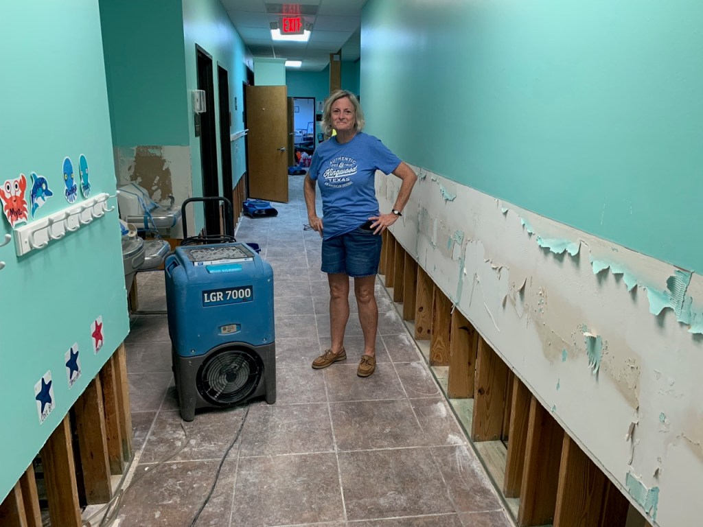
At this choke point, both the school and Kids in Action, flooded. Repairing the school after the May flood cost St. Martha $900,000. Repairing Kids in Action cost $500,000. This time it will cost each even more.
Behind St. Martha’s, Ben’s Branch becomes a narrow creek filled with trees. This further slows water down and backs it up. It remains like this most of the way to Kingwood Drive.Image courtesy of Father TJ Dolce.
The natural creek also makes many tight turns. Here, it makes a 150 degree turn followed by a 90 degree turn.Image courtesy of Father TJ Dolce.
The results were costly. St. Martha’s lost two classroom buildings plus its playground.
One of the two St. Martha School buildings flooded by Imelda.Flooded corridor.Flooded classroom.
Until the school buildings can be dried, disinfected and rebuilt, classes are being held on upper floors and in other parish buildings. No children were ever endangered by the flood. Parish personnel started evacuations to higher buildings as soon was water started coming into the parking lot, the lowest point on the campus.
Across the creek, Kids in Action, one of Kingwood’s most popular day care and after school facilities, had its own problems.
A distraught Diane Havens, owner of Kids in Action, tries to keep a brave face after she loses the use of her beautiful facilities for the second time in four months.Hand sanitizer is the second thing you see in the reception area now.Havens is bringing in four of these mobile units to hold classes until the first floor of Kids in Action can be restored again.
Haven’s spent $500,000 repairing her facilities after the May 7th flood. That’s a lot for a small business. She’s determined to weather this storm, too. But she worries that some of her clients may grow impatient in the inconvenience during repairs.
Choke Point #3: Kingwood Drive and Ben’s Branch
As Ben’s Branch approaches Kingwood Drive from the northwest, it spreads out into a 100+ acre forested area that includes the Creekwood Nature Center. But just before it crosses under Kingwood Drive, Ben’s Branch’s flood plain funnels down between Kingwood High School and the old H-E-B shopping center. At that point, a second branch of the stream joins it from the north. After crossing under Kingwood Drive, it is further constricted on the east side by commercial development. This represents another choke point.
The Kingwood High School Gym and Natatorium (bottom left) took on floodwater during Imelda.
The Kingwood High School gym and natatorium took on several inches of water during Imelda when drains and/or Ben’s Branch backed up. Merchants in the old H-E-B shopping center also report being stranded in their stores for two hours at the peak of Imelda as water from Ben’s Branch raced through the parking lot. Merchants said the water was inches from coming in their stores.
While many of the businesses south of Kingwood Drive in Town Center and Kings Harbor reported having water lapping at their foundations, I found none that reported flood damage.
No Simple Fix
I can’t think of a simple fix to all of three of these problems. Fixing one could compound the others. For instance, it would be simple to replace the culverts under Northpark with a bridge when the street is widened. However, that would just increase the volume of water backing up where the creek narrows between St. Martha’s School and Kids in Action. That would likely flood them even worse.
Channelizing the creek all the way to Kingwood Drive would likely be unpalatable from a political point of view. Four reasons: Few people in that area were affected. They all love their greenbelts. And the costs would be high. That would make the Benefit/Cost ratio of the project a non-starter.
One Possible Solution
One possible solution: convert the unused land around St. Martha’s new church north of Northpark Drive to additional detention. That’s valuable land and detention is expensive, but it may be a better alternative than losing the school which was just expanded in 2008. Father TJ Dolce is pitching that idea and hopes the Archdiocese would approve the use of their vacant land for detention. The big question: Would it be enough to make a difference.
Drainage Study Already Under Way
Thankfully, Harris County Flood Control is conducting a Kingwood-wide drainage study right now. They are studying Ben’s Branch. Hopefully, their talented engineers will be able to find the optimum solution that protects everyone. I sure hope they find it soon because these people are every bit as desperate as the people who flooded twice in Elm Grove and North Kingwood Forest.
Ben’s Branch may affect fewer structures. But it probably affects more people when you add up enrolled students and their families.
Posted by Bob Rehak on 10/1/2019with help from Father TJ Dolce, Diane Havens, Lela Yorba, Daryl Palmer and National Helicopter Service.
763 Days since Hurricane Harvey and 12 since Imelda
https://i0.wp.com/reduceflooding.com/wp-content/uploads/2019/09/Flooded-Building.jpg?fit=1024%2C768&ssl=17681024adminadmin2019-09-30 22:48:212019-10-01 22:33:30Imelda Floods Ben’s Branch Schools, Homes at Three Choke Points
In June and July, Harris County Flood Control cleared the upper portion of Ben’s Branch near Northpark Drive and Woodland Hills. Now, excavation of the lower portion of Ben’s Branch between Kingwood Drive and the YMCA on West Lake Houston Parkway has begun.
Looking south from the Kingwood Drive Bridge over Ben’s Branch. Fuddrucker’s and Remax are out of frame to the left.
One of the Largest Drainage Features in Kingwood
Ben’s Branch is one of the major drainage features in Kingwood. The purpose of the project: to restore conveyance. The stream/ditch cuts diagonally through the center of the community from the new St. Martha Church to King’s Harbor. Thousands of homes and businesses depend on Ben’s Branch to evacuate storm water efficiently.
Prior to Harvey, the ditch had not been cleared out in decades. It had become seriously clogged from erosion. Kingwood badly needs this maintenance.
Damages Near Ben’s Branch
During Harvey, Ben’s Branch contributed to the flooding of:
Every business in Kingwood’s busy Town Center area
Every home in the Enclave
Hundreds of homes in Kings Forest, Bear Branch, Foster’s Mill and Kingwood Greens
Kingwood Country Club’s Forest Course and Golf Advantage School
The Kingwood YMCA and Library
Kingwood High School
Hundreds of apartments
Twelve seniors in Kingwood Village Estates also died as a result of injuries sustained during evacuation or the stress of dealing with condos that the storm destroyed.
Construction will last through the end of the year. HCFCD will remove approximately 77,000 cubic yards of sediment. Crews began work at Kingwood Drive and are heading downstream. They have not yet reached the point where Ben’s Branch turns east, cuts under West Lake Houston Parkway, and then curves around the Y to head south again.
The project extends from Kingwood Drive downstream to 1,800 linear feet downstream of West Lake Houston Parkway.
HCFCD project started at the red line and is heading south.
Example of how badly Ben’s Branch has become silted. Approximately 70-80% of the conveyance was lost. The little orange dot in the upper center of the frame is a member of the HCFCD survey crew. Image taken last spring, looking west from West Lake Houston Parkway Bridge.
Traffic and Other Impacts
Construction equipment will access the work area via the established access points from Kingwood Drive, Bens View, West Lake Houston Parkway, and Denmere. The contractor will use heavy construction equipment such as dump trucks, excavators and bulldozers. Motorists are urged to be alert to truck traffic when passing near construction access points.
In order to repair and remove sediment from Ben’s Branch, the contractor will need to remove some trees and vegetation along Bens Branch, and in areas designated for access to the channel from the public road right of way.
https://i0.wp.com/reduceflooding.com/wp-content/uploads/2019/09/BensBranch_04.jpg?fit=1500%2C1000&ssl=110001500adminadmin2019-09-12 12:31:172019-09-12 12:31:25Excavation of Lower Portion of Ben’s Branch Kicking into High Gear
Good news! Jason Krahn with the Harris County Flood Control District (HCFCD) has announced that the District will start restoring conveyance capacity to Bens Branch beginning August 19, 2019. The contractor’s official start date is that Monday, but it will take several days to move equipment to the site. “So the citizens of Kingwood should see the contractor on site by midweek,” said Krahn.
Project Scope
The project will include removing and disposing of approximately 76,285 cubic yards of sediment accumulations. This will be a multi-step process. First, HCFCD’s contractor, Solid Bridge Construction, LLC, must remove the soil from the creek. Then the soil must drain and dry. Finally, dump trucks will remove the excavated material.
Scope of Ben’s Branch project outlined in red.
The project will extend from Kingwood Drive south to the library, then east under West Lake Houston Parkway to the YMCA, then south again to an area adjacent to Deerwood Country Club. It will stop 1800 feet from the river where the the ditch flattens out into a natural stream, near the Y canoe launch.
Sedimentation restricting the conveyance of Ben’s Branch between the library and West Lake Houston Parkway. Looking west from bridge.
The east/west portion of this project above became severely silted during Harvey, contributing to flooding in Kingwood Greens, Town Center, the Enclave, Kingwood Village Estates. A dozen seniors died in Kingwood Village Estates from injuries sustained during the evacuation or from the stress of seeing their homes destroyed when they returned.
City Portion of Ditch South of Y Not Included
The City of Houston reports that it has not yet secured maintenance easements from adjoining property owners south of the Y.
Most of the ditch adjoins property owned by the Clubs of Kingwood. Here’s what it looks like from a drone. My thanks to Jim Zura of Zura Productions for his time and expertise in securing this footage.
Ben’s Branch out of the YMCA looking toward Lake Houston. HCFCD project does NOT include this portion which is controlled by the City of Houston. Note the dredge operation in the distance at the end of this video. Drone footage courtesy of Jim Zura, Zura Productions.
For more information about the project, consult the Kingwood pages of the HCFCD website. The project ID is # G103-33-00-X004 – Bens Branch Conveyance Restoration.
Krahn expects the lower portion of Ben’s Branch to take 9 months. Construction equipment will access the work area via the established access points from Kingwood Drive, Bens View, West Lake Houston Parkway, and Denmere. The contractor will use heavy construction equipment such as dump trucks, excavators and bulldozers. Motorists should stay on high alert for truck traffic when passing near construction access points.
Expect Extra Traffic
The average commercial dump truck holds ten to fourteen cubic yards. So this project could result in 5,500 to more than 7,000 round-trips before its over.
Posted by Bob Rehak on 8/12/2019 with video from Jim Zura of Zura Productions
713 Days since Hurricane Harvey
https://i0.wp.com/reduceflooding.com/wp-content/uploads/2019/08/g103-33-00-map_web.jpg?fit=600%2C413&ssl=1413600adminadmin2019-08-12 16:44:492019-08-12 16:59:52Ben’s Branch Clean Out to Begin August 19
In response to citizen requests after the May 7th flood, Harris County Flood Control District (HCFCD) has been excavating the portion of Ben’s Branch near North Park Drive and Woodland Hills Drive in Kingwood. The St. Martha Catholic school on the south side of the creek and Kids in Action on the north side both flooded during that event.
Infrequent Maintenance and Upstream Development Took Their Toll
The ditch had become badly filled in due to infrequent maintenance and upstream development. This project, covered by HCFCD’s maintenance budget began last month.
Thomas Blailock, a reader, has been sending in these pictures showing the progress.
Much of the creek has been cleared already. And just in time for Hurricane Barry! I’m sure all the merchants along North Park are breathing a sigh of relief.
Looking west from Woodland Hills at Bens Branch. Photo courtesy of Thomas Blailock.Looking east from Woodland Hills at Bens Branch. Photo courtesy of Thomas Blailock.By comparison, here’s a “before” shot taken about two weeks ago. Photo courtesy of Thomas Blailock.
Next Up: Lower Portion of Ben’s Branch
This project is separate from the excavation that will soon begin on Ben’s Branch south of Kingwood Drive. We should soon see about 8,000 truckloads of dirt coming out of that reach of the stream.
Twelve senior residents of Kingwood Village Estates died near that area after Harvey. They passed as a result of injuries suffered during the evacuation or the stress of losing their homes.
Taylor Gulley for an Encore
Next up: the upper portion of Taylor Gulley…followed by additional clearing of debris in the lower portion later this summer. Approximately 200 homes flooded adjacent to Taylor Gully in the March 7th storm, due in part to upstream development which has deposited sediment at higher than normal rates in the channel.
A shout out to Barbara Hilburn of Kingwood Lakes who raised awareness about internal drainage issues after Harvey. She has worked long and hard to jumpstart these clean outs.
Posted by Bob Rehak on 7/10/2019
680 Days since Hurricane Harvey
https://i0.wp.com/reduceflooding.com/wp-content/uploads/2019/07/IMG_2071.jpg?fit=1500%2C1125&ssl=111251500adminadmin2019-07-10 15:10:052019-07-10 15:11:31Excavation Continues along Upper Ben’s Branch while HCFCD Gets Ready to Begin on Lower Portion
Jeff Miller, an Elm Grove resident, just reported receiving a note from Harris County Flood Control District (HCFCD). Will Sherman, HCFCD’s Precinct 4 coordinator, indicated the following.
Plans for Taylor Gully
The right-of-way transfer to HCFCD for the upper portion of Taylor Gully (see map below) is scheduled to be on the next Commissioners Court agenda on July 9th.
HCFCD right of way access along Taylor Gully (left) should be complete by July 9.
That portion of Taylor Gully has become badly clogged with sediment due to the construction of Woodridge Village upstream just across the Montgomery County line.
Part of the erosion in the area clearcut for the new Woodridge Village subdivision. Tree line on the left is the Harris/Montgomery County Line. No erosion control measures were in place at the time of this photo during the heavy rains in early May.
Here’s what Taylor Gully looked like on 6/24/19.
Reinforced concrete box culvert on Taylor Gully at the Harris/Montgomery County Line. 10′ high culverts appear to be half clogged with sediment. Harris County is in foreground. Woodridge Village and Montgomery County are in background.Photo by Jeff Miller.
HCFCD plans to do it again “soon” as part of a general debris removal process on multiple channels in Kingwood.
The wider effort should begin this August.
Blockage on lower portion of Taylor Gully. Photo courtesy of Chris Kalman.When banks erode and trees fall into ditches and creeks, the trees can catch other debris floating downstream and form “beaver dams” that back water up into neighborhoods.
Work on Ben’s Branch Expanded
Yesterday, HCFCD extended its work on Ben’s Branch west of Woodland Hills. They excavated the area between North Woodland Hills and the businesses on the south side of North Park Drive (Walgreens, Firestone, McDonalds, etc.).
HCFCD maintenance work along Bens Branch west of Woodland Hills Drive in Kingwood. Photo courtesy of Thomas Blailock.
To Report Blockages Near You
If you are aware of downed trees blocking a channel near you:
Photograph it using a cell phone (most of which embed GPS coordinates in images)
Record the nearest street location and trail-access points
With contributions from Jeff Miller, Thomas Blailock and Chris Kalman
673 Days after Hurricane Harvey
https://i0.wp.com/reduceflooding.com/wp-content/uploads/2019/07/IMG_2433.jpg?fit=1200%2C900&ssl=19001200adminadmin2019-07-03 16:39:352019-07-03 17:07:47HCFCD Schedules Maintenance for Taylor Gully, Other Ditches
Here’s some much needed good news regarding Bens Branch. One small maintenance project began last week and an even bigger one should kick off within the next two weeks. Bens Branch cuts diagonally through Kingwood and drains a major portion of the community.
Bens Branch Between North Park and St. Martha Started Last Week
Last week, Harris County Flood Control crews began excavating Bens Branch from North Park to below the old St. Martha’s church. In recent years, the creek had become badly silted and overgrown with vegetation. When the May 7th rains hit, several local businesses flooded including the St. Martha Catholic School and Kids in Action. County maintenance should soon restore normal conveyance through this area. These photos taken last Friday by Thomas Blailock, a Bear Branch resident, show how badly the creek had become constricted.
Photo of Bens Branch taken from Woodland Hills Bridge on Friday, 6/28/2019. Kids in Action is in background. St. Martha is out of frame on the right. Courtesy of Thomas Blailock.
Another photo courtesy of Thomas Blailock showing how badly Bens Branch was constricted in this area.
Note how shallow the ditch has become. Only the bottom tread of the excavator was visible in this standing water.
Bens Branch South of Kingwood Drive Starts Next Month
Bens Branch at West Lake Houston Parkway immediately south of Amegy Bank.
Excavation of approximately 80,000 cubic yards of sediment should begin in July and last for several months. Prepare for dump trucks on the road for the next few months. It will be inconvenient and dirty, but that’s the price of restoring the conveyance of the creek.
This portion of Bens Branch contributed to the flooding of Town Center, The Enclave, Kingwood Village Estates, Kingwood Greens, the YMCA and Kings Harbor and five apartment complexes. Twelve people in Kingwood Village Estates died as a result of injuring sustained during the evacuation or the stress of losing their homes when they returned.
Jason Krahn, the project manager at Harris County Flood Control said last Friday that, “A recommendation to award Project ID # G103-33-00-X004 – Conveyance Restoration on Bens Branch to Solid Bridge Construction, LLC, has been made, and that recommendation to award is scheduled to be on the Harris County Commissioners Court (HCCC) Agenda for HCCC approval of the recommendation to award on July 9, 2019.”
Once the award has been officially voted on and approved by the Commissioners Court, the Harris County Purchasing Agent’s office will work to obtain the executed contract, and the necessary bonds from the Contractor so that the project can move forward to construction. Expect to see about 40 dump trucks per day (8600 loads in total) on the streets of Kingwood.
Money for both of these projects does not come out of the flood bond. It comes from the Harris County Flood Control District Maintenance Budget.
Posted by Bob Rehak on 6/30/19
670 Days since Hurricane Harvey
https://i0.wp.com/reduceflooding.com/wp-content/uploads/2019/06/Blailock-1.jpg?fit=1500%2C1125&ssl=111251500adminadmin2019-06-30 21:28:512019-06-30 21:29:01Maintenance and Construction Work Beginning on Bens Branch
Bens Branch cuts diagonally through the heart of Kingwood. Project area circled.
Current Conditions on Ben’s Branch
During Harvey, hundreds of homes and businesses flooded near the creek. It contributed to flooding in Kings Forest, Town Center, The Enclave, Kings Harbor, and Kingwood Greens. The project area affects all of those subdivisions, plus Kingwood Village Estates where 12 seniors died, either as a result of injuries sustained during evacuation or the subsequent stress of losing their homes.
Harris County Surveying Crew in Ben’s Branch just west of West Lake Houston Parkway and south of the Kingwood Library. More sediment buildups just east of West Lake Houston Parkway on Ben’s Branch, south of the Enclave and north of the YMCA.
Next Steps for Ben’s Branch
Since the announcement of the project to restore conveyance on Ben’s Branch, HCFCD has been busy negotiating access rights to the stream. The District has also finalized construction plans and bidding specs. According to Beth Walters, a flood control district employee who lives in Kingwood, here’s what to expect next and when.
“We plan to advertise the project five times,” says Walters, “to attract bidders. Ads will appear through June 15.” She also said HCFCD held a mandatory pre-bid meeting for all interested parties.
Eleven potential bidders attended. “Hopefully, we’ll get some good unit prices,” said Jason Brock, the manager of HCFCD’s maintenance engineering department.
Project Award by July 9, Construction to Start Immediately
HCFCD expects to open bids on June 17th and award the project at the commissioner’s court meeting on July 9. Mark your calendars!
The winning bidder will have 250 calendar days, per the contract, to finish the job. That means the project should be finished by next February or March.
Status of Other Kingwood Projects
Yesterday, Commissioners Court approved a Kingwood Area Drainage Assessment Plan. The objectives of the plan are to:
Dermine the current conveyance of all creeks and ditches in the Kingwood area
Measure that against current and projected needs
Make recommendations for improvements.
But first, HCFCD must select a consultant. The project should kick off this summer after consultant selection.
In the meantime, HCFCD is repairing damage due to Harvey at several locations.
1. Project ID G103-38-00-X020 consists of repairs at three (3) locations along G103-38-00:
a. Site 5416 consists of slope failure repair, including excavation of sloughed materials, disposal of unsuitable materials, and rebuilding side slopes. The Site is located approximately 1900 feet north of Walnut Ln.
b. Site 5680 consists of erosion repair and pipe replacement including reestablishing channel toelines, and rebuilding side slopes. The Site is located approximately 250 feet south of Walnut Ln.
c. Site 5682 consists of erosion repair including excavation of sloughed material, reestablishing channel toelines, and rebuilding side slopes. The Site is located approximately 500 feet northwest of Deer Ridge Estates Blvd.
2. Project ID G103-38-01-X010 consists of repairs at one (1) location along G103-38-01:
a. Site 3228 consists of slope erosion repair including rebuilding side slopes. The Site is located approximately 70 feet west of Chestnut Ridge Rd.
3. Project ID G103-41-00-X008 consists of repairs at two (2) locations along G103-41-00:
a. Site 5622 consists of slope erosion repair including lishing channel toelines, excavation of soils to reestablish channel width, and rebuilding side slopes. The Site is located approximately 1350 feet south of Kingwood Dr.
b. Site 5622A consists of channel scour and slope repair including filling scouring with a well graded mix, reestablishment of channel toelines, and rebuilding side slopes. The Site is located approximately 1600 feet south of Kingwood Dr.
For more specific information about Flood Control projects in the Kingwood area, including vegetation management, click here.
Posted by Bob Rehak on June 5, 2019
645 Days after Hurricane Harvey
https://i0.wp.com/reduceflooding.com/wp-content/uploads/2018/09/KingsCrossing_3_01.jpg?fit=1500%2C663&ssl=16631500adminadmin2019-06-05 10:22:582019-06-05 13:36:30Update on Ben’s Branch and Other Drainage Repair Projects from Flood Control District
Jason Krahn of the Harris County Flood Control District (HCFCD) revealed plans tonight to begin restoring the conveyance of Bens Branch, one of the largest drainage channels in Kingwood. Bens Branch runs diagonally through the center of Kingwood from the new St. Martha Catholic Church to east of Kings Harbor where it joins the San Jacinto West Fork.
Harris County Flood Control will soon begin removing more than 8000 truckloads of sediment clogging Ben’s Branch.
Welcome Relief
News of the project will bring welcome relief to those who live near the creek and who flooded during Hurricane Harvey. Among them are residents of North Woodland Hills, Kings Forest, Bear Branch, Town Center, the Enclave, Kingwood Village Estates, and Kings Harbor.
Restoring Conveyance to 1990 Level
The objective of the project: to restore the conveyance that existed in 1990 when the creek was last widened and improved. Large portions of the creek have severe silting.
Krahn says Flood Control plans to excavate 1.3 miles of the ditch from near Kingwood Drive to past the YMCA – a total of 6,851 linear feet. The project will stop approximately 1,800 feet from Lake Houston. From that area, they plan to excavate 77,365 cubic yards of sediment that have built up since 1990. That equals about 8,600 dump-truck loads.
Flood Control also plans to bring in rock to shore up areas that have severely eroded.
Project Phasing and Timeline
The design phase of the project has completed and bidding will begin within two weeks, says Krahn, the project manager.
To access the areas to be excavated, Flood Control will use a combination of roads and adjacent property owners. They include Kingwood County Club, Harris County Precinct 4 Library, the YMCA, and the Kings Crossing Trail Association.
Expect the following phases:
Establishing access
Erection of construction fencing
Mobilization of equipment such as amphibious trackhoes and shallow-draft barges
Excavating material and storing it along the edges of the creek
Waiting two weeks for it to drain and dry
Hauling it away
Krahn expects to haul off 40 truck loads per day. He says the project should take a total of 250 calendar days. Thus, they should complete the project by next January.
Some trees may have to go, but Krahn vows to make every effort to keep as many trees as he can. He says he understands how much Kingwood values trees. He also points out that any trees on the banks did not exist when the ditch was last excavated; they have grown up since.
Procurement, bidding, and planning will run from April through June. Expect to see boots on the ground no later than July 1.
$2.1 Million Cost Expected
Total cost of the project is projected at about $2.1 million out of a $17 million total maintenance budget for all of Harris County. This money does not come out of the flood bond. It comes from the normal HCFCD maintenance and operations budget.
Soil Already Tested; Non-Hazardous
The county has already sampled and tested the soil that it will remove. It received a Class 2 Non-Hazardous Rating. That means it is not contaminated and can be stored anywhere. Krahn says that the winning contractor will propose disposal sites. Sometimes the fill will be used in road beds, to elevate property, or returned to old sand pits.
Warn Kids to Stay Away
Many people fish and play in the creek and job on its banks. Krahn requested residents to keep their children away from the construction zone once heavy equipment starts moving in. Operators will have their eyes on the job and not people jogging or fishing.
Thanks to Barbara Hilburn
A shout-out to Barbara Hilburn of Kingwood Lakes who has doggedly led the charge on internal drainage improvements since Harvey. Hilburn emphasized the need for a Kingwood-wide study of internal drainage to restore the entire system to its original capacity. She hopes that will work hand-in-hand with other improvements being made to the San Jacinto and the Lake Houston dam to reduce flood risk.
Posted by Bob Rehak on 3/20/2019
568 Days since Hurricane Harvey
https://i0.wp.com/reduceflooding.com/wp-content/uploads/2019/03/BensBranch-copy.jpg?fit=1024%2C768&ssl=17681024adminadmin2019-03-20 22:43:072019-03-20 23:29:16Harris County Flood Control to Begin Restoring Conveyance of Bens Branch In April
My apologies. On Wednesday, I posted about easements along Ben’s Branch and Taylor Gulley. The story said that the City of Houston had finally sent long-awaiting documents to Harris County Flood Control that would allow the County to assume maintenance of those areas. It was based on assurances from a source at the City that the documents had finally been sent to the County.
However, different documents actually arrived at the County. They covered a small portion of Taylor Gulley and a small drainage ditch in King’s Forest that parallels Valley Manor west of Kingwood High School.
Like many of the drainage ditches in Kingwood, after annexation, this ditch west of Valley Manor and Kingwood High School fell into a maintenance black hole. The County has now received an easement from the City of Houston that will allow it to maintain the ditch.
Here are maps of the two areas for which documentation has actually been sent to Harris County:
My source at the City now says, “I am working with the legal team to have a full update on all the outstanding channels as well as have requested the expedited completion of Bens Branch.”
To see an interactive map of Harris County drainage projects in Kingwood, go to the Harris County Flood Control District website and see the Kingwood section.
Posted by Bob Rehak on September 7, 2018
374 Days since Hurricane Harvey
00adminadmin2018-09-07 07:49:542018-09-07 07:53:22Correction on Post about Ben’s Branch and Taylor Gulley