Tag Archive for: 2026 Atlantic Hurricane Season

Tropical Forecast Lowered for Remainder of 2026 Season

8/6/2026 – One of the strongest El Niños ever is suppressing tropical activity in the Atlantic, Caribbean and Gulf. El Niños create wind shear that disrupts the formation of tropical storms and hurricanes. As a result, forecasters have lowered their estimates which were already below normal to begin with.

NOAA Updates Seasonal Forecast

In an email this morning, Jeff Lindner, Harris County’s meteorologist, wrote, “Updates to the seasonal Atlantic basin hurricane outlooks this week continue to indicate a high chance of below to well below normal activity across the Atlantic basin as we move through the peak of the season (August-October).”

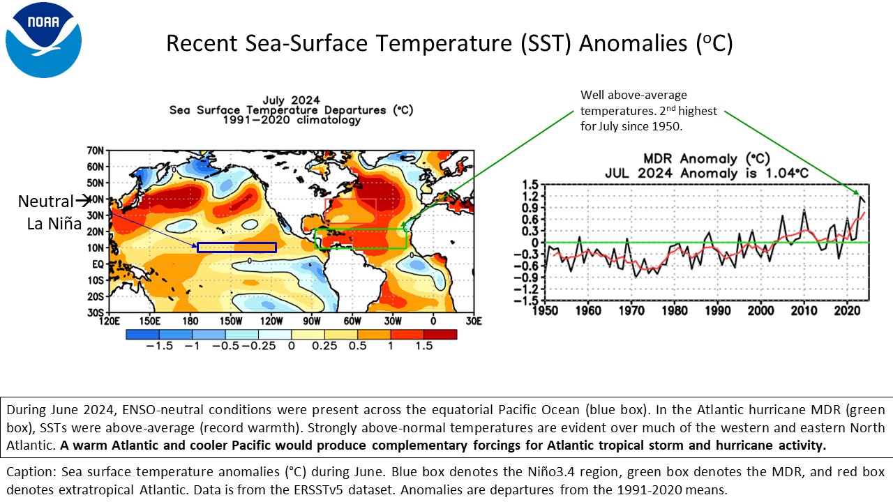
That’s welcome news. “The main driver of the highly negative conditions is the continued increasing El Niño event well underway in the waters of the eastern and central Pacific Ocean. There, sea surface temperatures are currently running (1-3º C above normal values),” said Lindner.

El Niño Region 3.4 (the dark area off the western coast of South America) tends to correlate highly with weather impacts in North America, including shifts in the jet stream. Niño 3.4 is currently averaging a sea surface temperature anomaly of +2.3º C.

One of Worst El Niño Events since 1950

“That already approaches some of the maximum El Niño events since 1950,” added Lindner. “With the likely peak of this event around December or January…it is now fairly likely that one of the strongest El Niño events in modern times will occur.”

El Nino events, especially of this magnitude, tend to produce tremendous wind shear values across the deep tropics in the Caribbean and tropical Atlantic. They effectively tear apart any tropical system attempts at development.

“Wind shear values of 40-60 kts have been common across the Caribbean so far this hurricane season,” said Lindner. “They extend eastward into the tropical Atlantic and are some of the strongest on record in this part of the basin.”

In addition to the high wind shear values, Lindner also cited dry sinking air that continues to dominate much of the Atlantic Ocean and Caribbean. He noted slightly more favorable conditions north of the Bahamas and through the northern Gulf.

Sea surface temperatures are running near normal to slightly above normal in some parts of the Atlantic basin. High negative wind shear values and dry sinking air are resulting in lower than average instability and a general overall lack in thunderstorm activity.

“One of the Quietest Seasons since 1997”

Accordingly, the seasonal outlook numbers for the basin remain well below the average of 14 named storms. Two “tropical storms” have already occurred (Arthur and Bertha) both of which impacted the northern Gulf coast and suffered greatly under adverse conditions keeping their intensity low and organization poor.  

The basin is on track to be one of the quietest seasons since 1997 (another powerful El Niño year).

Lindner says there will be small windows of favorable conditions, most likely in August and September. For instance, areas in the middle Atlantic north of the highly unfavorable deep tropics could produce a few storms if tropical waves can reach those areas.

Budding meteorologists may be interested in reading NOAA’s entire seasonal outlook updated today. It’s a deep dive into the science of tropical forecasting.

It Only Takes One

Remember! Just because the outlook numbers are lower than average, does NOT mean there will not be any additional tropical storms or hurricanes or potential threats this year.  So remain prepared.

Posted by Bob Rehak on 8/6/2026 based on information from Jeff Lindner

3264 Days since Hurricane Harvey

Gulf Water Temps Near Record Highs with Hurricane Season Just Days Away

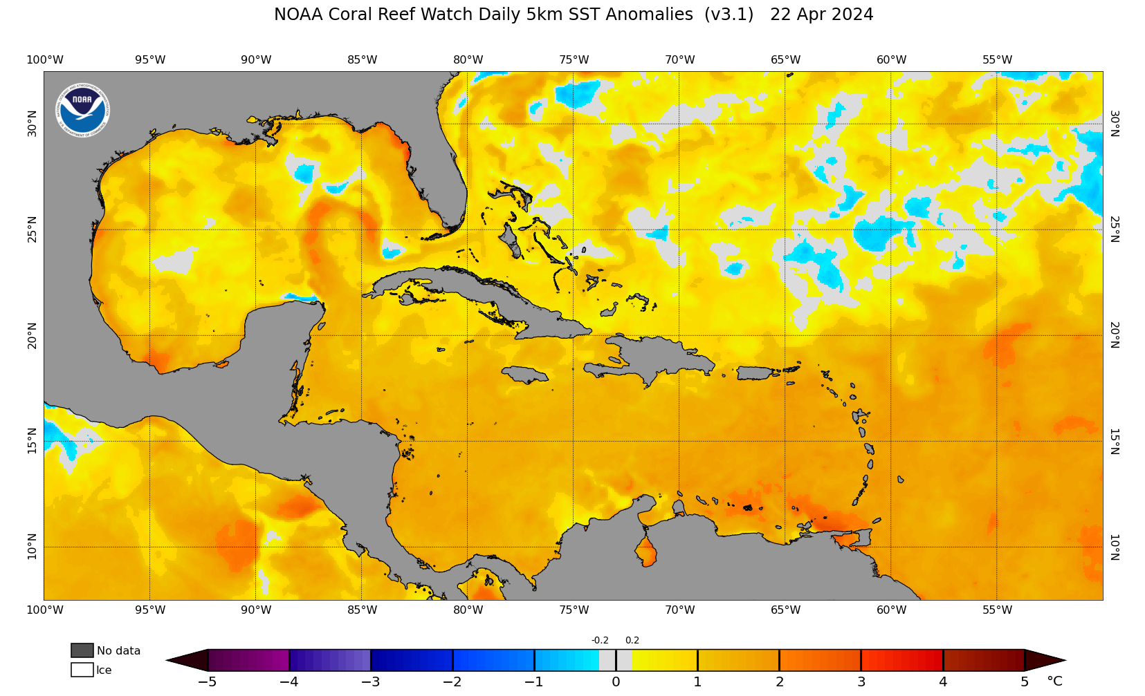
5/27/26 – Based on sea-surface temperatures (SSTs), weather forecasters are already talking about the possibility of an early season tropical storm in the Gulf. NOAA’s SST Anomalies page shows that as of yesterday, Gulf water temps were already well above normal and near record highs set in 2024.

Such SSTs help form tropical systems by warming the air and making it rise. Hurricane forecasters note that a significant lack of hurricane activity in 2025 left the region with an abundance of hot water that was not “churned up” or cooled by major storms.

Although NOAA predicts a below-normal Atlantic season with eight to 14 named storms, the near-record heat in the Gulf—averaging 2.5 degrees warmer than normal—remains a significant “wild card” for storm intensity.

Conflicting Trends

The other major factor influencing tropical forecasts this year is the growing El Niño.

El Niño tends to suppress tropical storm formation in the Atlantic by creating wind sheer that tears apart tropical storms before they intensify.

However…

Early season storms – even during El Niño years – can and do create widespread damage.

Consider these “A” storms:

  • Hurricane Andrew in 1992 (Cat 5) ranks as the 9th most costly storm
  • Tropical Storm Allison in 2001 ranks # 23 on NOAA’s list of all-time costliest storms.
  • Hurricane Agnes in 1972 (Cat 1) ranks as the 22nd most costly storm
  • Hurricane Alicia in 1983 (Cat 3) ranks as the 33rd most costly storm.

A story by Dinah Voyles Pulvery in today’s USA Today titled “Hurricane forecasters fear supercharged, early-season storms in 2026″ contained almost two dozen terrifying pictures from Hurricane Agnes in 1972.

Matthew Rosencrans of NOAA’s Climate Prediction Center told USA Today that El Niño has the biggest impacts on Atlantic hurricanes that form deep in the tropics. But in the Gulf, there may be more favorable pockets for storms to form.

Three of the four storms above happened during El Niño years.

  • 1983 was a major El Niño year – one of the strongest of the 20th century. Forecasters considered it unprecedented at the time.
  • 1972 was one of the more significant 20th-century El Niño events prior to the very large 1982–83 event.
  • An El Niño that developed in 1991 persisted through much of 1992.

2001 had neutral conditions. El Niño did not develop until 2002.

Don’t Underestimate Potential for Rapid Intensification

Just hours ago, AccuWeather warned that sea surface temperatures in the Gulf are already running near the threshold for tropical development.

And according to Ken Graham, director of the National Weather Service, people often think hurricanes will give them more lead time than they actually do. But that’s not usually true. Graham told USA Today. “Every Category 5 that’s made landfall in this country was a tropical storm or less at three days out.”

For hurricane preparation tips, consult the Preparation Tab on my Links Page. Hurricane season officially starts in five more days. Also…

Save the Date: Flickinger to Host Preparedness Open House

On Thursday, June 4, from 5-6:30 PM, Houston City Council Member Fred Flickinger will host an open house at Kingwood Community Center (4102 Rustic Woods Drive, Kingwood TX 77345) with:

  • Houston Office of Emergency Management
  • CenterPoint Energy
  • Comcast
  • xfinity
  • UnionPacific
  • Trees for Houston

According to the Council Member, the event will feature practical safety information about resources designed to help you, your family and your neighborhood prepare with confidence, such as:

  • Safe vegetation practices and the Right Tree, Right Place approach
  • When and why to call 811 before you dig
  • How to stay safe around railways and utility equipment
  • Hurricane preparedness tips and local resources

Flickinger said, “Ask questions, explore helpful information and share what matters most in your neighborhood so we can better support the community we serve.”

One of the first things people often lose in Kingwood is power when trees fall against overhead lines. And with the loss of power comes loss of communication. So it’s important to have a plan before that happens.

Posted by Bob Rehak on 5/27/2026

3193 Days since Hurricane Harvey

NOAA Predicts Below-Normal 2026 Atlantic Hurricane Season

5/21/2026 – Forecasters with NOAA’s National Weather Service predict a below-normal hurricane season for the Atlantic basin for 2026. The Atlantic season runs June 1 to November 30. NOAA predicts a 35% chance of a near-normal season, a 10% chance of an above-normal season, and a 55% chance of a below-normal season.

The agency predicts a total of 8-14 named storms (winds of 39 mph or higher). Of those, it forecasts 3-6 will become hurricanes (winds of 74 mph or higher). That includes 1-3 major hurricanes (category 3, 4 or 5 with winds of 111 mph or higher).

An average season has 14 named storms with seven hurricanes, including three major hurricanes. 

NOAA has a 70% confidence in these ranges. If the 2026 North Atlantic hurricane season ends up below-normal, it would mark only the second season in the last decade without above-normal activity. Since the current Atlantic high-activity era began in 1995, 22 of 31 (about 70%) seasons have had above-normal activity. Only 5 (17%) and 4 (14%) have had near- and below-normal activity, respectively. That’s based on the 1951-2020 climatology.

Also, 10 (almost half) of the above-normal years (thus 32% of the 31 years) have been hyperactive (ACE of 165% of median). 

Key Factors Driving NOAA’s Forecast

NOAA based its below-normal predictions on competing factors.

  • El Niño should develop and intensify during the hurricane season. This creates wind shear in the Atlantic which discourages hurricane formation.
  • Atlantic ocean temperatures should range slightly warmer than normal
  • Trade winds will likely be weaker than average.

El Niño conditions tend to support fewer tropical storms and hurricanes, while warmer ocean temperatures and low winds support a more active year.

“Although El Niño’s impact in the Atlantic Basin can often suppress hurricane development, there is still uncertainty in how each season will unfold,” said NOAA’s National Weather Service Director Ken Graham. “That is why it’s essential to review your hurricane preparedness plan now.”

“It only takes one storm to make for a very bad season.”

National Weather Service Director Ken Graham

Below are the storm names for 2026.

Not a Landfall Forecast

NOAA’s outlook is for overall seasonal activity based on large-scale weather and climate patterns. It does not indicate where or when any storms may affect land. That is determined by short-term and variable weather patterns. This is not a landfall forecast. 

Importance of Preparation

“Preparing now for hurricane season — and not waiting for a storm to threaten — is essential for staying ahead of any storm. Visit weather.gov/safety and Ready.gov for important preparedness information,” added Graham.

New, Enhanced Communication Products This Season

“NOAA’s rapid integration of advanced technology, including AI-based weather models, drones, and next-generation satellite data will deliver actionable science to safeguard the lives and livelihoods of the American people,” said NOAA Administrator Neil Jacobs, Ph.D. “These new capabilities will produce the most accurate forecasts possible to protect communities in harm’s way.”

  • NOAA’s National Hurricane Center (NHC) will implement an improved version of the tropical cyclone forecast cone graphic that will now include tropical storm and hurricane watches and warnings for inland areas for the continental United States, Hawaii, Puerto Rico and the U.S. Virgin Islands. 
  • NHC will begin testing an experimental version of the tropical cyclone track forecast cone that will capture a greater range of possibilities for the track of the storm by incorporating uncertainties for both direction of movement and timing.  

Advancements to Hurricane Analysis and Forecasts

Advances are not just in communication:

  • NOAA, in collaboration with the Unified Forecast System community, is testing an experimental high-resolution Seasonal Forecast System that utilizes the latest modeling technology and new methods to assess the evolution of the global ocean-atmosphere system. The system is helping forecasters better simulate tropical storms and hurricanes, and more effectively predict the number of hurricanes and major hurricanes. 
  • NOAA’s Atlantic Oceanographic and Meteorological Laboratory (AOML) is using machine learning to quality-control data collected from tail Doppler radar — a specialized radar system mounted on the back of NOAA’s “Hurricane Hunter” aircraft. This new method gathers more than 25% more meteorological data than the current method and leads to more high-quality data to support structure and wind analysis by forecasters.

New, Innovative Forecasting Technologies

The 2026 Atlantic seasonal outlook will be updated in early August, ahead of the historical peak of the season, which typically extends from mid-September through October.

Posted by Bob Rehak on 5/21/2026 based on information from NOAA and NWS

3187 Days since Hurricane Harvey