
NHC Issues Advisory on Potential Tropical Cyclone 9
9/23/24 at 12 PM – The National Hurricane Center has designated a disturbance in the northwestern Caribbean as Potential Tropical Cyclone 9. Currently, NHC gives the storm a 90% chance of development in the next two days.
According to Harris County Meteorologist Jeff Lindner, models indicate it will likely escalate into a Category 4 hurricane as it heads north over the warm waters of the Gulf.
However, it will likely make landfall along the Florida Panhandle. Current forecasts indicate no threat to Texas. Overnight, the projected track of the storm shifted farther east.
Projections as of Noon Monday
I’m posting this because Houston residents may have friends, relatives or travel plans in affected areas. See below.
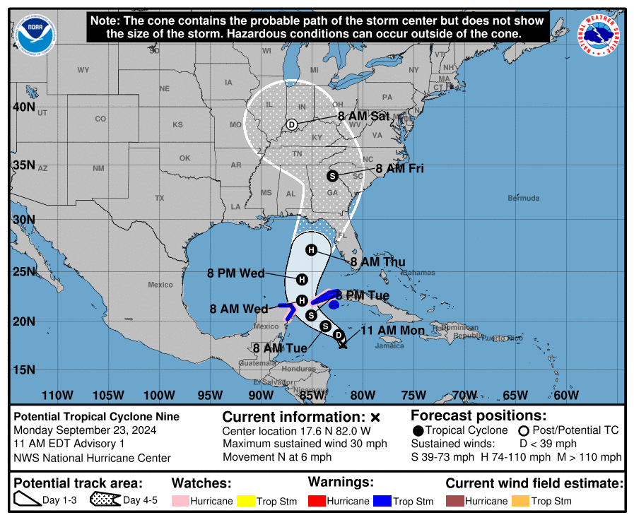
Tropical storm force winds associated with Potential Tropical Cyclone 9 should arrive in the big bend area of the Florida panhandle sometime between Wednesday night and Thursday morning.

NHC predicts a 50:50 chance for tropical storm force winds extending north into Georgia.

The National Weather Service has this to say for people in the Panhandle and southern Georgia, “There is a potential for significant storm surge; heavy rainfall and flooding; and strong winds across the north and eastern Gulf Coast.”
“Impacts could begin as early as Wednesday night and last into Friday,” says NWS. “More detailed and specific impacts will be highly dependent on future track/intensity and we’ll be including those in future updates in the next day or two.”
Winds have a 95 percent chance of a 75 MPH increase during the next 72 hours.
National Hurricane Center
Frequency of Major Hurricanes
When/if the Potential Tropical Cyclone 9 reaches 39 MPH, NHC will dub it Helene.
We’ve already had one major hurricane in the Gulf this year – Beryl. The second major hurricane usually develops in the Atlantic Basin by September 19. So, even though this season has fewer than normal named storms, it will have an average number of major hurricanes for this part of the season if Helene becomes a Category 3 or higher.

Current Status
At present, NHC says the area of concern in the northwestern Caribbean between Honduras and Cuba continues to produce disorganized showers and thunderstorms. Some mid-level rotation is evident in visible satellite images.
A gradual turn toward the northwest is expected during the next day or so. Models agree that the center of the system should reach the northeast Gulf on Thursday.
Since the disturbance currently lacks a well-defined center, future track adjustments may be required. Given the large size of the tropical-storm-force wind field and fast forward speed that is forecast, storm surge, wind, and rainfall impacts will likely extend well away from the center, particularly to the east of the system.
While the system is currently broad and not well organized, the models suggest a more well-defined center should develop during the next day or so.
Once the system becomes better organized and develops an inner core, the environmental and oceanic conditions appear favorable for significant strengthening. The sea surface temperature anomaly chart below shows that temperatures in the Caribbean and Gulf are up to 8 degrees Fahrenheit warmer than average for this time of year.

An Air Force Reserve reconnaissance aircraft will investigate the system this afternoon.
Tropical Storm Warnings and Hurricane Watches have already been issued for portions of western Cuba and the Yucatan Peninsula of Mexico.
Key Messages
- The disturbance will strengthen and be near hurricane strength when it reaches the far northwestern Caribbean Sea Tuesday night.
- The system will intensify and could become a major hurricane when it reaches the northeastern Gulf Coast on Thursday.
- There is an increasing risk of life-threatening storm surge and damaging hurricane-force winds along portions of the northern and northeastern Gulf Coast, including the Florida Panhandle and portions of the Florida west coast. But it is too soon to specify the exact location and magnitude of impacts.
- Potential Tropical Cyclone Nine will bring heavy rain to portions of the western Caribbean. That may lead to flooding and possible mudslides in western Cuba.
- Potential Tropical Cyclone Nine will likely produce total rain accumulations of 4 to 8 inches over western Cuba and the Cayman Islands with isolated totals around 12 inches.
- Heavy rainfall will spread into the Southeast U.S. starting on Wednesday and continuing through Friday, bringing a risk of flash and river flooding.

Posted by Bob Rehak on 9/23/24
2582 Days since Hurricane Harvey


