
Lake Level Reports in Advance of TS Imelda; Where to Find Up-to-Minute Info During Storm

Overnight, the offshore low that had only a 10% chance of developing into a tropical system, turned into a tropical depression and then a tropical storm called Imelda.
Houston Under Flash Flood Watch
As of 6 p.m. Monday evening, Harris County and the entire Houston area is under a flash flood watch.

For the latest updates visit the National Weather Service site.
Projected Path Of Storm Between US59 and I-45
If the storm stays on its present trajectory, the center should go right through the Lake Houston area. Note in the graphic above that the heaviest rainfall will be east of US59 along a line between Houston and Livingston.

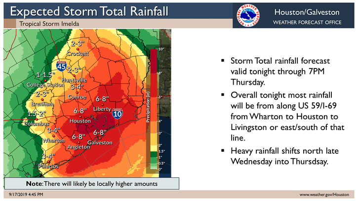
Rainfall Totals
The NWS predicts the three-day total rainfall for the storm could reach 6-8 inches, though professionals caution that much higher amounts are possible. For instance, if you live east of US59 and the track of Imelda, according to Harris County meteorologist Jeff Lindner, you might get up to 10-15 inches.
As the storm approaches from the southwest, the Lake Houston area will be on the dirty side, meaning we will get higher rainfall amounts than further west.
Lake Levels Down To Create Extra Buffer Against Flooding
In advance of the storm, the Coastal Water Authority is lowering Lake Houston. The normal elevation is at 42.5 feet. As of this writing, the Coastal Water Authority shows the pool level at 41.19 feet, about 1.25 feet below normal for a planned maintenance project.
However, effective immediately, the Lake level will be lowered to 40.9 feet, 2.6 feet below normal. This will create an extra buffer against flooding.
Houston City Council Member Dave Martin says, “All gates will remain open until the inclement weather threat leaves the area. After the weather threat has passed, gates will stay open until a level of 41.5 feet is reached allowing for the planned maintenance project to resume.”
The SJRA has lowered the level of Lake Conroe according to its seasonal plan. Lake Conroe is currently at 198.71 feet, a little more than 2 feet below normal. The plan called for 199; evaporation took the rest. Currently the SJRA is releasing 0 cubic feet per second. Check the SJRA website for up to the minute reports.
Dry Ground Will Absorb Initial Rainfall, Then Look Out
Because of extremely dry weather during July, August and early September, the ground should absorb much of the initial rain. However, because the rate could exceed 1-2 inches per hour at times, runoff will rapidly increase.
The first threat from this storm will be street flooding. Secondarily, it will be bayou and river flooding. You can track the latter at Harris County Flood Warning System and make sure you check out their near-real-time inundation feature.
Protective Actions
Be Prepared. People should bring their pets inside and delay travel or outdoor activities during periods of heavy rainfall. If travel is unavoidable, reduce your speed to avoid hydroplaning.
If a Flash Flood Warning is issued for your area, DO NOT travel.
Property owners should ensure that street drains and ditches are clear of debris, so storm water can flow without obstructions. Blockages of drains, ditches, and culverts are the most frequent cause of flooding in neighborhoods.
Clear Street Drains
Secure items that might float away in heavy rain and become lodged in drains or culverts. Avoid street parking to protect your vehicle and allow clear passage for response vehicles.
Turn Around, Don’t Drown®
Do not drive through flooded areas. If you see water covering the road, do not attempt to cross it. Only a few inches of water can float a vehicle . If you find yourself in a dangerous situation where your vehicle is taking on water, get out of the vehicle, get to a higher position, and call 911.
Monitor Official Sources for Current Information
Harris County Flood Warning System (harriscountyfws.org), Houston TranStar (houstontranstar.org), and the National Weather Service Houston/Galveston Forecast Office (weather.gov/hgx).
Monitor Stream, Bayou, and Creek Conditions
Rain may move repeatedly across the same area, causing creeks and bayous to rise and possibly exceed their banks. Stay informed of current conditions and avoid traveling near creeks and bayous.
Avoid Traveling during Periods of Heavy Rain
Rain can reduce visibility and prevent you from seeing the road ahead, which could lead to accidents.
Posted by Bob Rehak at 6 pm Tuesday, 9/17/19
749 Days since Hurricane Harvey


