Potential for Heavy Rainfall, Flash Flooding Increasing This Week
Low-pressure System Will Meander Near Coast
Lake Charles and Houston radars show numerous clusters and bands of heavy rainfall across Gulf waters associated with deep tropical moisture. These bands will soon begin to move onshore.


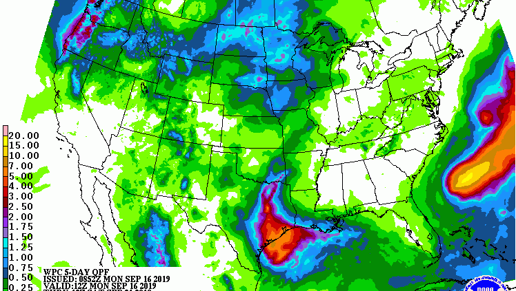
Cumulative Rainfall Potential Through Friday


According to Jeff Lindner, Harris County meteorologist, the National Weather Service and National Hurricane Center, models have come into agreement. They predict a surface-low pressure system may form just offshore on Tuesday and drift inland over southeast Texas Tuesday night into Wednesday. The National Hurricane Center currently gives the system only a 10% chance of tropical formation…
…BUT regardless heavy rainfall should result.
Ingredients appear to be coming together late Tuesday through Thursday for a heavy rainfall event over the region.
Endless Supply of Tropical Moisture
According to Jeff Lindner, Harris County meteorologist, “An endless supply of moisture will pump into the region. Formation of slow-moving, training rain bands appears likely over portions of the area.”
This weather system could produce excessive rainfall, enough to saturate dry ground in a short period of time. Rains today and Tuesday especially south of I-10 will saturate dry ground. Conditions by Wednesday should support much more run-off, over a wider area.
10-15 Inches Possible
Widespread rainfall amounts of 3-6 inches will be likely over much of the area with isolated totals of 10-15 inches possible.
Hourly rainfall rates of 3-4 inches will be possible under any training bands and any slow-moving clusters resulting in rapid-onset urban flash flooding. The threat for creek, bayou, and river flooding will increase by mid-week as grounds become increasingly saturated and run-off increases.
Flash flooding will be possible.
Posted by Bob Rehak on 9/16/2019 as of 9 a.m.
748 Days since Hurricane Harvey


