Tag Archive for: Royal Pines

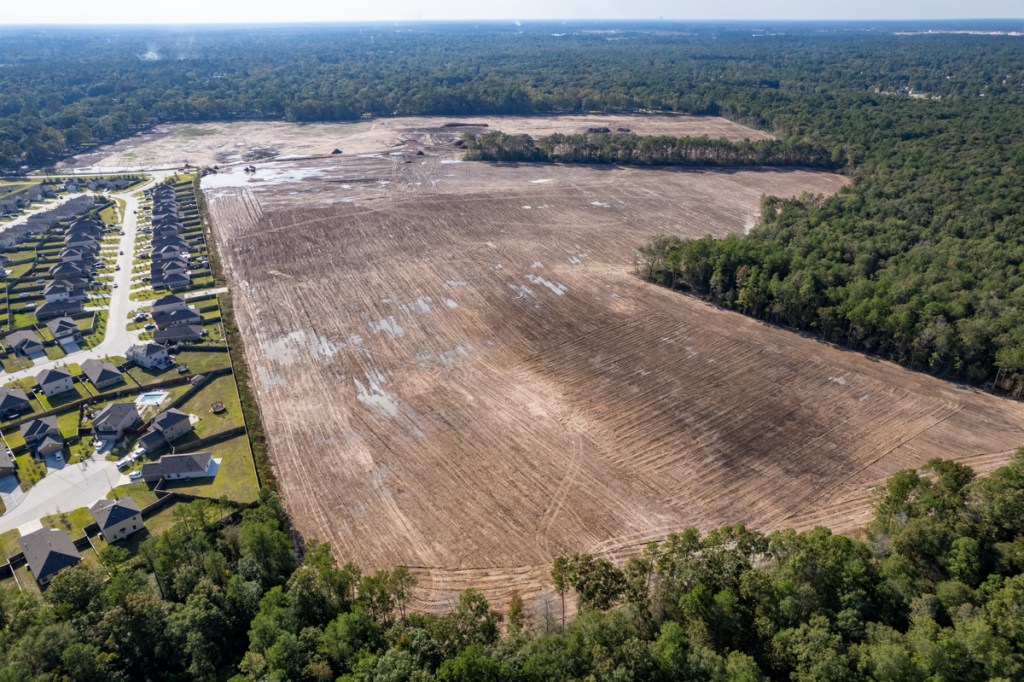
Royal Pines Construction Begins

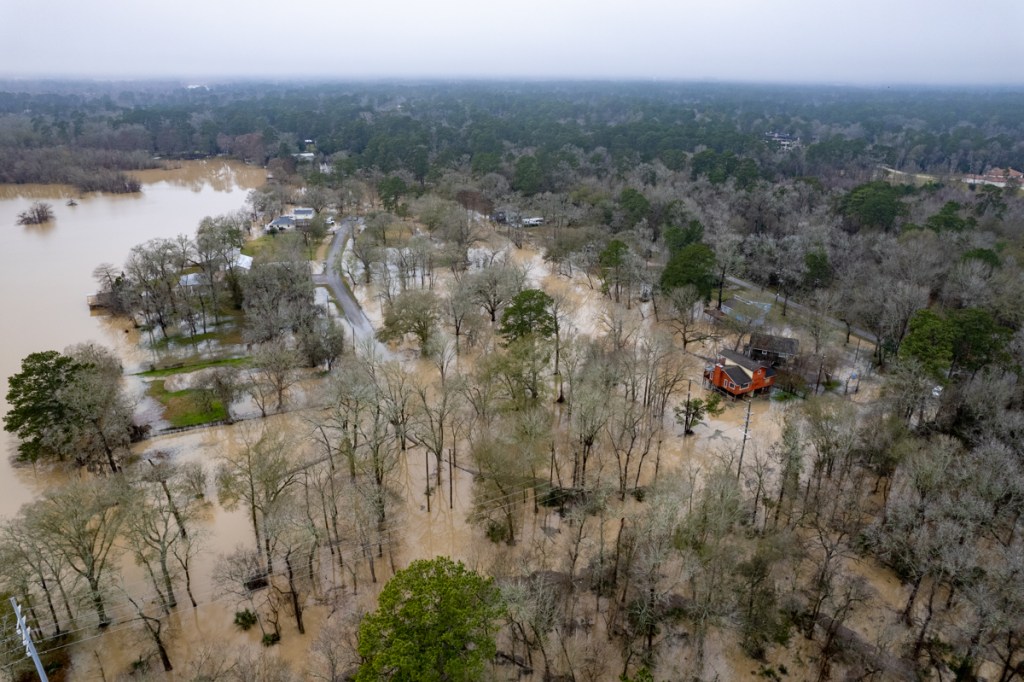
Royal Pines, a new, 150-acre development in Porter at the north end of West Lake Houston Parkway (WLHP) is mobilizing for construction. The developer began clearing and grading the site in April 2022. By September 2022, they finished. And by October 2022, they were flooding neighbors.

For the past 18 months, they’ve been working on building two detention basins to help solve the flooding problems as they finalized their drainage and construction plans. They recently received Montgomery County permits and are now mobilizing for construction.

In response to a FOIA Request, Montgomery County supplied the drainage impact analysis and construction plans today. But they are far too large to post here. They include 314 pages of technical drawings. And they total almost 400 megabytes. So I will provide a brief summary now and provide more detail after I dig deeper.

Two Phases, Three Sections in First

According to the drainage impact analysis, construction will take place in two phases.

The developer, Starlight Homes Texas, LLC, owns land in the floodplain and floodway of White Oak Creek. Approximately 40 acres – almost a third of the site – will be used for recreation and green space, but not homes.

The first phase of construction will have three sections clustered near the current northern terminus of WLHP. WHLP will later be extended farther north. Plans for Phase II have not yet been completed or approved.

Purple Area will be developed in Phase I and have three sections. Red area will be Phase II.

Altogether, the development will have 448 homes. About two thirds will be on 40′ wide x 125′ long, 1/8th acre lots. The rest will be 10 feet longer.

Drainage Impact Analysis Claims No Adverse Impacts

The drainage impact analysis was based on 2018 Lidar data and NOAA’s Atlas-14 rainfall probability statistics. Both are current.

Part of the site used to drain toward WLHP. But the drainage was altered during grading. Now, all but 2.5 acres flows to the two detention basins and White Oak Creek.

Western stormwater detention basin. Property in background flooded several times before basin was built.
Eastern stormwater detention basin does not quite follow schematic layout. It sits where White Oak Creek cut across property during a 5-year rain.

The drainage impact analysis provides a summary for how the detention basins will perform in 25- and 100-year storms. In either event and in either direction (White Oak or WLHP), the claimed post-development runoff is less than the pre-development. See table below.

From Page 15 of Drainage Impact Study by DE Corp., 10/9/23.

The drainage impact analysis makes a great deal about how the total discharge beats requirements by such a large margin. However, keep in mind that the analysis does not yet include runoff from Phase II.

The engineer, Amy Dziuk, makes a point that the surplus capacity will be used later for Phase II. She claims that Phase I will “not cause adverse impacts to the receiving waterways or surrounding areas.”

Photos of Equipment and Materials Being Staged

I took these photos on 4/15/24. Concrete and HDPE pipe as well as heavy equipment are scattered throughout Phase I of the site. See below.

Looking south toward Country Colony at equipment and materials being pre-positioned.
Green pipe is usually used for sewage or drain lines. Blue carries water.
Section 3, Phase I west of Country Colony

I also saw men cleaning the entrance to the site and repairing silt fence.

Looking S at north end of WLHP from entrance to Royal Pines

Perhaps the attention to housekeeping in the photo above will be a good omen. Let’s hope they keep it up.

Posted by Bob Rehak on 4/16/2024

2422 Days since Hurricane Harvey

The thoughts expressed in this post represent opinions on matters of public concern and safety. They are protected by the First Amendment of the US Constitution and the Anti-SLAPP Statute of the Great State of Texas.

Royal Pines Builds Stormwater Detention Basin, But…

The controversial new Royal Pines subdivision that flooded a neighbor four times in two months has finally built a stormwater detention basin.

The good news: The basin should capture water flowing from one direction toward the neighbor.

The bad news: The height of the berm around the pond could back up water from the opposite direction onto the neighbor’s property. The concentrated flow could also erode the earth over a natural gas pipeline.

Drainage Now Concentrated Over Pipeline

The pipeline is buried only 36″ deep along the silt fence in the photo below. So any floodwater coming from the west (right) will now be concentrated directly over the pipeline.

Water used to converge from both east and west toward a natural depression in the middle of the new development. But contractors changed the natural grade, confusing the situation.

Looking south from over White Oak Creek toward the new 6.3-acre detention pond in the NW corner of Royal Pines. Water drains toward camera.

The drainage impact analysis for Royal Pines below shows that 11.6 acres outlined in purple (labeled as OFF1, for offsite area #1) drains through the larger 49.5 acre area that contains detention Pond 1 shown in the upper left. The plans show a channel running about a quarter of the way down the left border where the silt fence now is, then mysteriously stopping.

From Royal Pines Drainage Impact Analysis dated April 2022.

When I first saw the plans, I assumed the water in that channel would empty into the pond. But no inlets are installed at that location. At least not yet even though others are installed elsewhere.) See below and above.

Looking west toward neighborhood that flooded from development. No inlets come from that direction.

Instead, water coming from the west will meet a wall approximately 8 feet high.

Wall of Royal Pines Detention Pond 1 next to homeowners lot.
The wall of the detention pond. This area used to slope down toward the trees in the background. Now you can barely see them.

The berm forms a dam against any water coming from the west (behind the camera position). That includes floodwaters from White Oak Creek.

So where will the stormwater go? Instead of spreading out, it will be squeezed between the berm and homeowners. That has the potential to cause more flooding.

That giant wall also has the potential to obstruct the floodplain and back water up during a storm, just as the berms around sand mines can.

From Royal Pines Drainage Impact Analysis

The analysis claims the development will have no adverse impact either up- or downstream. However, during a five-year rain in January, the level of White Oak Creek came up much higher than a five-year flood.

What’s on the ground counts for more than what’s on paper.

Another Danger Lurks 36″ Down

But there’s potentially an even bigger danger. A natural gas pipeline is buried next to that silt fence that borders homes along the western edge of the detention pond. Erosion from all that concentrated water rushing over the pipeline could expose it, just as it exposed another pipeline 1.5 miles away.

Erosion exposed a Kinder-Morgan pipeline at the Triple PG Sand Mine. See below.

Exposed Kinder-Morgan gas pipeline at Triple PG Mine

The Texas Attorney General is still suing the owner of the mine over dangerous business practices.

Same Cast of Characters

The man behind the mine, Prabhakar Guniganti, also owns or owned Royal Pines. His name shows up on the general plan, although the Montgomery County tax rolls show a company called TC LB Royal Pines LP now owns the property. It’s not clear if there’s a connection between Guniganti and the Royal Pines Limited Partnership.

The detail below taken from General Plans dated March 18, 2022 shows the Guniganti Family is part owner of the property. But Royal Pines allegedly bought the land from the 1992 Guniganti Credit Shelter Trusts on 12/9/21 – more than three months earlier.

So, will the real owner please stand up?

Master of the Corporate Shell Game

Guniganti has a history of corporate shell games. After the Attorney General sued him, ownership of his mine changed hands so many times that the AG had to add five shell companies to the lawsuit. The AG also added Guniganti as an individual and as a director of the companies/partnerships to the lawsuit. Because of all the delays, the case still has not gone to trial.

This does not inspire confidence. Especially among homeowners who may be flooded, but don’t have the State’s deep pockets.

When I and homeowners talked to Montgomery County Engineering last week, the developer did not yet have a construction permit for the pond. The county said only that if any changes become necessary, they will be at the developer’s expense.

Just a reminder. Section 11.086 of the Texas Water Code states, “No person may divert … the natural flow of surface waters in this state, or permit a diversion to continue, in a manner that damages the property of another…”

Posted by Bob Rehak on 2/25/2023

2006 Days since Hurricane Harvey

The thoughts expressed in this post represent opinions on matters of public concern and safety. They are protected by the First Amendment of the US Constitution and the Anti-SLAPP Statute of the Great State of Texas.

Floodwater Rising and More Rain On the Way

Surprisingly heavy rains in the last week of January 2023 have led to floodwater rising on area streams. As of 1:38 PM on Monday 1/30/23, the National Weather Service predicted minor flooding throughout much of the northern part of the Houston region, including:

  • East Fork San Jacinto near New Caney affecting Montgomery, Liberty and Harris Counties.
  • Peach Creek at Splendora affecting Montgomery and Harris Counties.
  • West Fork San Jacinto near Humble affecting Montgomery and Harris Counties.
  • Cypress Creek at Katy-Hockley Road affecting Waller and Harris Counties.
  • Menard Creek near Rye affecting Hardin, Polk and Liberty Counties.

One on Top of Another

Jeff Lindner, Harris County Meteorologist, said, “While response on area watersheds in the northern portions of Harris County may seem significant for the amount of rain Sunday, when you combine rainfall from Tuesday and Sunday, totals of 8-11 inches are found over this area. The rainfall combined with saturated soils explain the significant rises on area streams.”

From Harris County Flood Warning System

Photos of Flooding from 1/29 and 1/30

Here’s what all that rain looked like on the ground in the Humble/Kingwood Area last night and this morning.

Parked in wrong place. West Hamblen Road near West Fork.
Townsen Landing development in Humble near Target in upper left. Saratoga Homes plans to build 357 singl- family homes here.
Single- and multi-family residential, some of which will be dedicated to seniors on Townsen Blvd. West in Humble.
US59 South at West Fork. Underpass closed due to high water.
Looking N toward Lakeside Court and Treasure Lane between West Fork (left) and 59 (right).
Confluence of Spring Creek and West Fork just west of US59. Note distinctly different color of water coming from the West Fork (right) where we have 20 square miles of sand mines between 59 and 45.
Forest Cove Drive just north of West Fork
Lake Point Drive in North Shore
Contractors are expanding the permanent detention basin at the new Kingwood Middle School.

It looks like we’re beginning to see the outlines of a football field and running track at KMS. That’s the one bright spot in all of these bleak shots. And to think, a few months ago, we were worried about drought.

“Plays Well With Others”

Remember that box on kindergarten report cards – “Plays Well with Others”? These last few photos dramatize the need for developers and their contractors to play by the rules. Most do. But some don’t. These last few shots show how to make a bad situation worse.

New Royal Pines development draining into storm sewer. Note water pouring over storm fence and directly into drain without filtration. A big no no. Violates stormwater regulations and could plug up storm sewers eventually.
NW corner of Royal Pines floods neighbor in upper right. They installed silt fence last week. But unchecked runoff pushed it over the fence. See photo below.

Contractors sloped the land toward a neighbor’s property and have yet to build detention ponds. They have flooded the neighbor four times now in two months and have not done anything to correct the problem…at least nothing that has worked.

Same area but about several hours earlier. Weight of water pushed over silt fence.
Eastern portion of Royal Pines doesn’t even have silt fence between it and White Oak Creek.
Another part of Royal Pines eastern perimeter. More erosion heading toward White Oak Creek and the East Fork.
Preserve at Woodridge Detention basin is supposed to be grass lined, but instead is pouring silt into a tributary of Bens Branch which HCFCD just cleaned out.

Ain’t Over Yet

January, February and March are normally our three driest months. But not this year. It looks like we will get 2-3X the normal monthly total.

National Weather Service Climate Data for Houston

Ten to 11 inches in 7 days qualifies as a five-year rainfall by Atlas-14 standards.

NOAA Precipitation frequency estimates

And more rain is on the way. NWS predicts heavy rain arriving from the north on Wednesday. They also warn of flash flooding.

From NWS Weather Prediction Center

Share Your Flood Pics with the Community

If you have pictures of flooding that you would like to share, please use the Submissions Page of this website. Make sure to include the time, date, and location of the photo and how you would like the credit line to read.

Posted by Bob Rehak on 1/30/2023

1980 Days since Hurricane Harvey

5-Year Rain Brings White Oak Creek Close to 100-Year Mark in Royal Pines

Between 1:00 and 3:00 PM on 1/24/23, approximately 3.6 inches of rain fell over Royal Pines in southeast Montgomery County. According to Atlas-14 rainfall tables, that qualifies as a 5-year rainfall event. But floodwaters from White Oak creek approached the edge of the 100-year floodplain. And missing silt fences let sediment escape into the wetlands that border the property.

5-Year Rain

A friend who lives a mile from Royal Pines recorded about 4″ on his rain gage for the full day. A check of nearby rain gages on the Harris County Flood Warning System, showed that the official gage at FM1485 and the San Jacinto East Fork recorded approximately 3.6 inches between 1 and 3 PM today.

Harris County Flood Warning System hyetograph shows approximately 3.6 inches fell in two hours on 1/24/23.

Cross-referencing that rate with NOAA’s Atlas-14 rainfall probability estimates for this area, we can see that 3.6 inches in 2 hours equals a 5-year rain.

atlas 14 rainfall probabilities
NOAA Atlas 14 rainfall probabilities for Lake Houston Area.

100-Year Flood Line

Now let’s look at how close that 5-year rain came to the 100-year flood line. In the construction diagram below, the developer shows the edge of the 100-year flood plain. It’s the dotted line between Zone AE and Zone X. I’ve circled the relevant portion in red.

If you were to project that line toward the lower right, it would roughly parallel the heavy black line that forms the eastern boundary of Country Colony, which you can see in the middle right of the photo below.

Floodwaters from Creek Overflow Royal Pines

The water comes almost to the edge of the floodplain shown in the construction diagram above.

Looking SE across Royal Pines. County Colony in upper right.

That big area filled with water, is a part of White Oak Creek cutting across Royal Pines. Think it’s just standing water? Think again.

The closer shot below shows water streaming through the soon-to-be subdivision and filling the Country Colony drainage ditch to overflowing.

Notice the water streaming through the cleared area and carrying away sediment downstream.

Notice also how the floodwaters approach what appears to be some sort of water treatment facility in the upper right.

These shots also document the absence of silt fence on the eastern side of Royal Pines.

All that silt will migrate down White Oak Creek and Caney Creek into the East Fork San Jacinto which the City of Houston just dredged at great public expense. The public also must foot the bill for increased water-purification costs.

From Harris County Flood Education Mapping Tool.

More Missing Silt Fence in NW Corner of Royal Pines

The SE corner of Royal Pines wasn’t the only part of the development missing silt fence. The developer removed it from the NW corner – where a neighbor has now flooded three times in two months.

Looking N toward White Oak Creek. Contractors removed the silt fence last week. Rain then swept sediment into the woods.

Those woods contain sensitive wetlands.

Notice how water coming from the north (left) is clear. But water coming from Royal Pines (right) is filled with sediment.
The muck filled the wetlands for more than a mile downstream.

How Can a 5-Year Rain Reach Almost as Far as a 100-Year Floodplain?

We need an answer to that question before this development starts pouring concrete. There are several possible explanations.

  • Clearcutting accelerated runoff.
  • Bulldozers compacted soil, limiting the rate of infiltration.
  • The developer hasn’t built any stormwater-detention-basin capacity to offset the increased runoff.
  • Planners used old (lower) Montgomery County rainfall data to determine the extent of the floodplain in their plats and plans.
  • Engineers didn’t count on the cumulative impact of insufficiently mitigated upstream development, some of which used beat-the-peak, hydrologic-timing surveys to avoid building detention basins.
  • The developer altered the landscape.
  • More rain fell upstream than at the gage shown above.
  • Some or all of the above.

I took these photos within an hour of the end of the rain. So there wasn’t much time for water to work its way downstream very far.

Two floodplain experts I consulted pointed to the cumulative impact of upstream development as a possible culprit. Engineers are likely working with flood data acquired in the 1980s before Montgomery County became one of the fastest growing counties in the region. The data is simply too complex to adjust after each new development. So, it never gets revised and errors compound over time.

I’m sure the Montgomery County Engineers Office and TCEQ will want to get to the bottom of this before the developer starts building homes. If homebuyers flood on rains that are far less than 100-year rains, tremendous liabilities could result.

When Perry Homes attempted to build Woodridge Village – only one-half mile from Royal Pines – its engineers pretended no floodplains existed. That cost Perry Homes millions of dollars and its reputation.

If Royal Pines or Montgomery County would like to rebut the issues I’ve raised, I will be happy to publish their point of view. The public deserves to know what’s going on.

Posted by Bob Rehak on 1/25/23

1975 Days since Hurricane Harvey

The thoughts expressed in this post represent opinions on matters of public concern and safety. They are protected by the First Amendment of the US Constitution and the Anti-SLAPP Statute of the Great State of Texas.

This Is Not the Detention Basin

The photo below does not show the Royal Pines detention basin. It’s their main entrance at West Lake Houston Parkway.

And this was not a repeat of Woodridge Village on May 7th, 2019, when 7 inches of rain fell in one day. It was three separate rains totaling less than four inches spread out over four days.

Lake Royal Pines?

I’m not sure I’d want to buy a home in Lake Royal Pines. Here’s what it looks like from a lower angle.

Any more rain and the dump trucks would have to do double duty as high-water rescue vehicles.

Best Practices Call for Clearing One Section at a Time

Construction plans show that contractors appear to have clearcut 202 acres all at once. Seriously folks! This is why you don’t clearcut 200 acres all at once.

Best management practices suggest clearing one portion at a time and building the detention basin for that portion in a step-and-repeat fashion. That’s how it was supposed to work at Woodridge. But the boys on bulldozers got carried away.

This isn’t the only problem at Royal Pines. Earlier this month, runoff from the northwest corner flooded a neighbor’s property.

To their credit, the contractors subsequently put up extra silt fences in an effort to try to catch runoff. They also dug some trenches to channel runoff.

But despite the old high-school try, the measures still didn’t stop runoff from flooding the neighbor’s property for the second time in three weeks. The last time, though, it took less than an inch of rain. So at least they’re headed in the right direction.

Still, had they built the detention pond first…

Where the detention pond will go in the NW corner. Contractors appear to have graded their property toward this corner with nothing to catch the runoff except some flimsy fabric.
Runoff cascading toward the NW corner blew through and over the silt fences onto neighboring property. Photo by resident.

The mud line on the silt fences above represents the high water mark from the peak of the storm. This silt fence appears to be about 36″ tall and water pushed over the top of it in places.

Looking west from over flooded property. Despite the trench to channel runoff, earlier, the contractor graded the slope toward the left foreground where the detention pond will go.

The large trench above (and below) likely intercepted a lot of runoff and carried it away from the neighbor’s property. However, contractors dug the trench in the middle of the property. Not near the neighbor’s property. And it’s a pale imitation of the natural depression that they apparently filled in. See below.

The USGS National Map shows that, before clearcutting, the home on the left green marker was more than 7 feet above the low point several hundred feet east of the NW corner.
Looking South at trench.

Below, it looks as though they may have tried to start a second trench closer to the neighbors’ property, but if that’s what it is, it’s not nearly as deep or prominent.

Looking N. at trench (center). Notice second trench on the left that contractor started to dig but then filled in for unknown reasons.

Impact of Clearcutting on Runoff

To see a simple experiment that dramatizes the impact of runoff in clearcut areas, check out this 90-second video.

Posted by Bob Rehak on 11/26/22

1915 Days since Hurricane Harvey

The thoughts expressed in this post represent opinions on matters of public concern and safety. They are protected by the First Amendment of the US Constitution and the Anti-SLAPP Statute of the Great State of Texas.

Royal Pines Clearcutting Floods Neighbor on Less Than 1″ of Rain

As proof of how dangerous clearcutting without sufficient mitigation can be, the controversial Royal Pines development has flooded a neighbor on a rain that was less than 1″ – even as the Lake Houston area flirts with drought.

Royal Pines sits at the northern end of West Lake Houston Parkway in Montgomery County. Looking SE from NW corner on 10.31.22.

The circumstances are similar to those of a nearby development – Woodridge Village. There, clearcutting flooded Elm Grove Village and North Kingwood Forest twice in 2019. Without sufficient detention basins, sheet flow from approximately 268 acres swept through hundreds of homes. But those incidents weren’t during a drought. And the rainfalls were much heavier.

Less than an Inch of Rain

In this case, the rain fell on October 28, 2022. Harris County’s Flood Warning System recorded a peak of .72 inches of rain in an hour at the nearest gage. To put that in perspective, .72 inches is so slight that it would have had to have fallen in five minutes to qualify as a five-year rain or ten minutes to qualify as a one-year rain.

atlas 14 rainfall probabilities
NOAA’s Atlas 14 rainfall probabilities

However, the rain was spread out over about a half hour.

From Harris County Flood Warning System for West Lake Houston Parkway gage on 10/28/22.

And the soils were not saturated either. The Lake Houston Area has been in drought for much of the year. As of 11/5/22, the US Drought Monitor rated this area “abnormally dry.”

From US Drought Monitor

During the entire month before October 28, the area had received only a little more than a half inch of rain.

From Harris County Flood Warning System for month before rain in question.

Sloping Land Toward Neighbor’s House

The flooding occurred in the northwest corner of the new development. From pictures and emails supplied by the neighbor, aerial photos taken during the last several months, elevation profiles obtained from the USGS national map, and construction plans obtained via a FOIA Request, I’ve been able to piece together the following. It appears that:

  • Montgomery County asked the developer to revise its plans for a detention basin.
  • Before approval of the revisions, contractors clearcut 200+ acres.
  • Contractors filled in a natural depression that channeled runoff toward White Oak Creek and sloped the development toward the neighbor’s home.
  • Runoff from the .72-inch rain rushed toward the northwest corner of the development.
  • Silt fences funneled most of the runoff toward the corner, where it broke through the fence.
  • Runoff also seeped under the fence.
  • The runoff washed sediment across the back of the neighbor’s property toward White Oak Creek.

See the YouTube video below.

Video shot by resident on 10/28/22
Sloping mudline on silt fence shows how land had been angled toward this corner. The lower elevation used to be to the right. See discussion below.
Water and muck running onto neighbor’s property through break in corner. Water also ran underneath silt fence.
Aerial photo taken five days later on 11/2/22. Notice all the muck still in the corner and the silt deposited in the woods.

The neighbor’s property extends on a straight line beyond the left fence. Water flowed from bottom of frame toward corner.

Wider shot taken after the rain on 11.2.22 shows contractor tried to fill in trench eroded by runoff.
On 11.5.22, contractors repaired the silt fence and installed additional silt fences to slow and block runoff.

Luckily, the neighbor’s house did not flood. But a heavier rain might have flooded it.

Development Now Slopes Toward Neighbor Instead of Away

The USGS National Map shows that this area used to slope AWAY from their property, NOT TOWARD it.

Left side of image shows contour (brown line) from USGS National Map before land was cleared. Right side shows area east of the resident’s home used to slope down more than 7 feet in about 250 feet.

In this area water flows from the bottom of the frame toward the top where White Oak Creek is. Comparing the contours on the left above and depression on the right with the direction the water actually travelled confirm that contractors altered the slope of the land.

Yet Chapter 11.086 of the Texas Water Code begins “No person way divert … the natural flow of surface waters in this state, or permit a diversion … that damages the property of another …”

Missing Detention Basin

Construction plans show that the developer was supposed to have built a detention basin in the corner that flooded.

Royal Pines
Royal Pines construction plan shows detention basin in northwest corner. Also note same contour shown on USGS map above.

However, the Montgomery County Engineer’s Office has reportedly asked for changes to the design of the detention basin. A sound business practice would have been to avoid clearcutting that area until the basin could have been excavated immediately.

Montgomery County does not require the approval of construction plans before clearcutting. This story shows why that should change. Delays expose people to more flood risk.

Normally, October is the second rainiest month in Houston. We average 5.46 inches.

Clearly, the flooding shown in the pictures below could have been much worse in a normal year.

Let’s hope they get that stormwater detention basin built before heavier rains return! And let’s also hope that other contractors learn this clearcutting lesson.

Posted by Bob Rehak on 11/6/2022

1895 Days since Hurricane Harvey

The thoughts expressed in this post represent opinions on matters of public concern and safety. They are protected by the First Amendment of the US Constitution and the Anti-SLAPP Statute of the Great State of Texas.

From Lush Forest to Pine Barrens in 7 Months

Today, Royal Pines looks vastly different from the way it did last April. If such a thing as “truth in development naming” existed, they would have to call it “The Barrens of Kingwood.”

I first reported on the clearing of 200+ acres for this new development back in April 2022.

Royal Pines
Extent of clearing on April 24, 2022.

Now see the four photos below taken from different angles on 10.31.22.

Looking NE from Porter across the barrens.
Looking SE. The only thing taller than tire ruts are some piles of mulch that still need to be hauled away.
Looking West from near White Oak Creek. Country Colony on left.
Looking West from entrance.

Royal Pines bought the land from the 1992 Guniganti Credit Shelter Trusts on 12/9/21. The Guniganti family owns the Triple PG sand mine east of the area being cleared. You can see it in the background of the first two photos above.

The development company is headquartered in Tempe, Arizona according to the Montgomery County Appraisal District website.

Clearing started before TCEQ issued a Stormwater Pollution Prevention permit.

They Call This Progress

Compare what the development looked like:

Royal Pines
Plan for Royal Pines

The plan above shows that 80+ homes are in the pre-Atlas-14, 100-year floodplain. Six are in areas LOWER than the 100-year flood plain.

Use of old flood-plain maps could put unsuspecting buyers at risk. The flood plain maps for this area were last updated in 2014. New Atlas 14 maps may not become official for several more years…potentially after this developer starts selling homes.

The subdivision at buildout will comprise at least three sections. Houston Business Journal said Royal Pines will ultimately feature between 350 and 450 homes targeted at first-time home buyers.

Other developers are in the process of clearing hundreds of additional acres farther up White Oak Creek.

Plans for the Barrens

The following links will show you the general plan and layouts for the first three sections of Royal Pines:

Posted by Bob Rehak on 11/2/22

1891 Days since Hurricane Harvey

The thoughts expressed in this post represent opinions on matters of public concern and safety. They are protected by the First Amendment of the US Constitution and the Anti-SLAPP Statute of the Great State of Texas.

Clean Sweep for Royal Pines

Developers of the new Royal Pines subdivision at the north end of West Lake Houston Parkway have made a clean sweep. They appear to have finished clearing and grubbing more than 200 acres. See the pictures below taken on 9/17/22.

Looking east toward the Triple-PG mine in the background. The current terminus of West Lake Houston Parkway is in upper right.
Clearing began in April. Still looking east. Country Colony is in upper right.
Piles of dead trees being turned into mulch. Looking S toward West Lake Houston Parkway, top center.
Looking W. Not a tree left standing on where homes will be built. Nor a tree left standing between Royal Pines and Country Colony on left.

Trees As “Nuisance”

For most developers, including this one, trees are a nuisance. You have to work around them. They make it difficult to work the earth. And they often die later because of compaction of their roots by heavy machinery. Also, for smaller lots, there may not be enough room to leave trees and build a home at the same time.

But wholesale destruction like this can also contribute to flooding. We saw that a half mile southwest of Royal Pines at Woodridge Village when contractors cleared almost 700 acres before installing stormwater detention basins.

But beyond flood risk, marketing suffers. Marketers often try to build awareness by building a mystique around brands. Their goal: turn buyers into brand ambassadors. By preserving trees, Kingwood turned tens of thousands of families into brand ambassadors.

Missing Magic

It’s the most effective form of advertising possible. But Royal Pines won’t have it. Let me retell a true story that dramatizes the principle.

I’ll never forget one Christmas Eve when our kids were young. At dusk, snow started falling gently. I called the family together to witness the magic moment as Christmas music played in the background.

As we huddled at the front door, two deer strolled in front of us. You should have seen the kids’ eyes light up. They wanted to know which of Santa’s deer they were. It was our best Christmas ever.

You can’t buy publicity like that. More than 30 years later, I still tell that story.

Sadly, the kids who live in Royal Pines will likely never know a magic moment like that.

Oh, someone will eventually buy each home … even the ones in the flood plain. But the developer won’t have word-of-mouth advertising like I and my neighbors gave the original Friendswood Development Company. They won’t have tens of thousands of happy customers bragging about their community. Instead they’ll have a name that likely triggers a cynical comment as potential buyers enter the subdivision for the first time.

Impact of Clearcutting on Runoff, Water Quality

Clearcutting does more than drive wildlife away. It also increases runoff and reduces water quality. To see a simple experiment that dramatizes the impact, check out this 90-second video.

Progression of Clearcutting to Date

Also see the progression of clearing at Royal Pines during the last six months in these related posts.

Posted by Bob Rehak on 9/17/2022

1845 Days since Hurricane Harvey

202.8 Acres of Royal Pines Gone. Was It Necessary?

Since April 2022, I’ve documented the ever-widening clearing of the new Royal Pines subdivision at the north end of West Lake Houston Parkway. See what the development looked like in:

At the end of August, it appeared as though the clearing was close to complete. Massive piles of dead trees remain to haul away. But the cleared area closely matches the general plan shown below.

Looking ENE across the new, barren Royal Pines subdivision
Looking SSE from NW corner of Royal Pines
Looking WNW across Country Colony and Royal Pines, the clearing in the background.
General Plan for Royal Pines. Click here for higher resolution version.

Why Developers Clearcut: Pragmatism, Profit, Affordable Product

All across the region we see this same scenario played out over and over again. Why?

Bloomberg points out, “Money, of course. For homebuilders, trees are a nuisance. To keep a tree alive while building on a lot, they have to keep heavy equipment far away so they don’t compact the soil above its roots. They also can’t push soil up around the trunk. Preserving trees means keeping the topography of the lot unchanged, which often doesn’t fit their plans.” 

Memphis Daily News interviewed the president of the local homebuilders association there. The article says that “a developer’s stance on clear-cutting trees often depends on landscape and lot sizes. It’s easier to save trees on larger lots because they allow more room to work.”

“If a developer goes in and he decides he’s going to do two-acre lots, trees are no issue and they’re going to stay,” said Tim Wilson, president of the Memphis Area Homebuilders Association’s executive board. “But if a builder decides the best use for a piece of property is 40-foot lots, then the trees are coming down, every single one of them. That’s because there is no room for a house and a tree on a 40-foot lot.”

Majority of Lots 40-42 Feet

Exploring the links below will show you the general plan and layouts for the first three sections of Royal Pines. Most of the lots are, in fact, 40 to 42 feet wide:

The rising costs of land, borrowing, and building materials are forcing developers to squeeze more homes into smaller spaces to keep the homes affordable. In the Preserve at Woodridge, the lots are even smaller: 13 to the acre instead of 4-6.

That increases impervious cover. Unless sufficient detention and retention basins slow the water down, accelerated runoff increases the time of concentration downstream. That builds faster, higher flood peaks.

Effect of Urbanization on Peak Stream Flows” by Dr. William Dupre, professor emeritus from the University of Houston.

Impact on Environment

Sciencing.com points out that clearcutting also has other environmental impacts. They include erosion, pollution and flooding. “

“The roots of trees hold moisture and keep soil in place, protecting it from washing away during wind and rain. This erosion can also lead to flooding in waterways. Because trees are no longer holding the soil in place, rain flushes the sediment into waterways. … That can impact the river’s ability to flow properly and cause flooding.”

White Oak Creek

All along White Oak Creek, new developments are springing up. At 242 and FM1314, Mavera wetlands have bitten the dust.

Farther east, White Oak runs through the massive Valley Ranch area and the new Amazon transportation facility at 59 and 99.

Then Royal Pines borders White Oak as you get to West Lake Houston Parkway.

Finally White Oak joins Caney Creek, the East Fork San Jacinto and Lake Houston. (See below.)

White Oak Creek Watershed from the Texas Watershed Viewer.

All this clearcutting has the potential to increase runoff, erosion and sedimentation that could require future dredging…at public expense.

Eventually, the ground cover and forest canopy will regrow. But what about in the meantime? Neighbors have been lucky so far unlike those in Elm Grove and North Kingwood Forest.

Posted by Bob Rehak on 9/5/22

1833 Days since Hurricane Harvey

Tree Muggers for Tree Huggers: The Irony of Royal Pines

The “Tree Muggers” at the new Royal Pines subdivision in Montgomery County at the north end of West Lake Houston Parkway continue their relentless and remorseless destruction of trees. How ironic considering that the name implies the developer will market homes to Tree Huggers! Perhaps they:

  • Feel the name will blind customers to the reality.
  • Will offer to plant a ceremonial sapling at closing.

Houston Business Journal said Royal Pines will ultimately feature between 350 and 450 homes targeted at first-time home buyers.

Construction Status on 7/30/2022

Here’s what Royal Pines looked like at the end of July 2022.

Dead tree limbs stacked two stories high awaiting removal. Newly cleared area is at top of frame to the left of Country Colony in the upper right.
Higher angle shows proximity to the Triple PG sand mine in the background. White Oak Creek runs between the mine and the subdivision.
Looking NE toward Triple PG sand mine in background. The extent of clearing as of the end of July 2022.
Looking SSE across Royal Pines toward the current terminus of West Lake Houston Parkway.
Looking SW. The distant clearing is Woodridge Village where similar clearcutting contributed to the flooding of hundreds of homes in Elm Grove and North Kingwood Forest twice in 2019.
Same direction, but closer and higher. Note the contrast with previous development practices that tried to build homes among the trees.

Ever-Widening Clearing

Compare what the development looked like:


Tree Muggers’ Plans

The following links will show you the general plan and layouts for the first three sections:

Old Floodplain Maps Will Put Unsuspecting Buyers at Risk

Note the dotted lines that snake their way through the top of the development. Those represent the 100- and 500-year floodplains.

Notice how a large part of the development is in “Zone X (Shaded).” That’s the area between the limits of the base flood (100-year or 1% annual chance) and the 0.2-percent-annual-chance (or 500-year) flood. I counted more than 80 homes in that zone. I also see six already INSIDE the 100-year zone.

Keep in mind that these flood zones are based on PRE-Harvey estimates. FEMA shows that Montgomery County last mapped this area in 2014. When FEMA approves new POST-Harvey flood maps in the next few years, those zones will expand to take in more of the subdivision. 

In Harris County, MAAPnext is revising maps based on higher rainfall probability statistics and current changes in development. And a lot of development has occurred upstream of Royal Pines on White Oak Creek.

MAAPnext advises that, in general, new flood maps will show floodways expand into the 100-year flood zone and the 100-year expanding into 500-year by about 50%.

This is the same problem I talked about yesterday with the Kingland West development in Harris County at the Grand Parkway and the East Fork.

We won World War II in less time than it’s taking to release these new flood maps. Ironically, by the time they’re released, the Tree Muggers will have already invalidated the basis for the new maps. And thus, the cycle of flooding continues.

Posted by Bob Rehak on 7/30/2022

1797 Days since Hurricane Harvey

The thoughts expressed in this post represent opinions on matters of public concern and safety. They are protected by the First Amendment of the US Constitution and the Anti-SLAPP Statute of the Great State of Texas.