Tag Archive for: erosion

Earth Week Part 4: Slope of Sand Mine Dikes, Riparian Vegetation and Cost Offsets

Yesterday, I posted about how greater setbacks from rivers could improve safety for sand mines and downstream residents. Setbacks reduce the potential for erosion, sedimentation and consequent flooding. Here’s a related post that shows what happens when you try to build too close to rivers.

Note repairs to dike. I took this photo two weeks after Harvey.

First, understand that the closer you mine to the river, the steeper the slope of dikes must be. At a certain point, the slope becomes so steep that:

  • Grasses and trees can’t take root in it.
  • The loose soil becomes prone to erosion.
  • During floods, water in the river rises faster than in the pit.
  • It exerts pressure on the dike.
  • The dike can collapse through one of more of several mechanisms (piping, erosion, overtopping, sloughing, etc.)
  • The river invades the pit.
  • Depending on the depth of the pit, the volume of sediment in it, and the force of the flood, sediment could be carried downstream.

Another factor leading to dike collapse in the photo above is the road built on top of it. Running heavy equipment over the sandy soil causes it to compact and push outward. Vehicle traffic also keeps vegetation that could bind the soil from growing.

Accidents Waiting to Happen

It doesn’t take a Harvey-scale flood to breach these loose dikes. The unmemorable July 4th flood of last year breached the dike shown above.

Another flood on December 7th last year breached a dike in another sand mine downstream from the first one in three places!

Repairs to one of three dike breaches at a sand mine in Dec. 7 flood last year. Photo by Don Harbour Jr.

Here’s another breach at the same mine that hadn’t yet healed when I photographed it on September 28th last year.

Site of a breach in the dike of a sand mine. Note how the loss of vegetation has led to erosion and sloughing in the sandy soil.

When such breaches happen on both sides of a point bar, the river will “capture” the pit by rerouting through it – the shortest distance between two points.

West Fork sand mines on 8/30/17, one day after the peak from from Harvey

West Fork vs. East Fork and Value of Riparian Vegetation

Almost all of these problems could be solved by greater setbacks from rivers. That would retain more natural riparian vegetation and allow lower, more gradual slopes on dikes. It would also allow additional re-vegetation to take hold.

Shooting across the West Fork from on top of the dike shown in the first photo above. Note how loose the soil was in the foreground and how difficult it is to establish vegetation on the opposite shore in the middleground. Floods have torn away the erosion blankets trying to establish grass on the steep slopes.

Imagine 131,000 cubic feet per second ripping through a channel like this. That’s how much came down this portion of the West Fork at the peak of Harvey. It’s easy to see how the river could erode these dikes and invade the mines.

That’s why we need greater setbacks. It will allow more conveyance through the normal channel. And if we just leave native negation in place, it should help hold the dikes in place.

Now contrast the images above with this one taken on a portion of the East Fork where there are no sand mines.

Lush riparian vegetation and trees held the banks in place during Harvey.

Here’s another.

Offsetting Opportunity Costs with Conservation Easements

Mother Nature’s solution to sedimentation is free. If we could only just learn to respect the river and its flood plains. Yes, there would still be some sedimentation to deal with, but not nearly as much.

The loss of sand close to the river is an opportunity cost, not an out-of-pocket cost. Groups like the Bayou Land Conservancy can help offset some of that opportunity cost by providing income in exchange for conservation easements. I wish miners would explore this option more…for everyone’s benefit including theirs. It certainly might reduce their legal costs.

Posted by Bob Rehak on April 27, 2019

606 Days after Hurricane Harvey

Dangers of Erosion when Developing Floodplains

A resident of The Commons on Lake Houston contacted me about some severe erosion in her community. I can only describe it as stunning. It destroyed trails owned by the Property Owners Association that people used for hiking, biking and horseback riding. The loss of these trails limits recreational opportunities and has physically divided large parts of the community.

Sadly, it didn’t have to be that way. Infrastructure and ditch maintenance did not keep pace with development.

As development crept closer to the East Fork of the San Jacinto over the years, the erosion worsened. In older neighborhoods on higher ground, a series of small check dams in a major drainage canal reduced erosion.

A check dam is a small dam constructed across a drainage ditch to counteract erosion by reducing water flow velocity. 

Wide grassy, gentle slopes and check dams keep erosion at bay in areas first developed.
The last check dam. Downstream, it’s different. 

Below Check Dams, Uncontrolled Erosion

The dams stop short of the East Fork. A tiny swale that residents used to step over has expanded into a steep-sided gully approximately 20 feet deep and 50-75 feet wide. Not even concrete can stop the erosion now.

Concentrated runoff below the check dams has peeled away concrete used to reduce erosion around this pipe.

Trails used to run alongside and across this ditch. Now they’ve been swallowed. Residents have nicknamed the ditch “The Grand Canyon.” They fear walking near the edge because of potential for cave-ins.

Water exits the other side of the pipe with the force of a fire hose. It has eroded a huge bowl, now eating trails and trees.
Further downstream, a shallow ditch has turned into what residents now call “The Grand Canyon.”
Resident points to where part of a horseback riding trail caved in.
Trees falling into the center force the water wider during floods, worsening erosion.
This tree created an eddy that ate away a foot path. It went from lower left to upper right.

Causes of Erosion

Erosion can result from many things. Multiple factors played a role in the Commons.

As the developer built up land to elevate foundations, he increased the slope. That accelerated runoff.

Clearing land for a new subdivision along the ditch also accelerated erosion of soft, sandy soil.

Finally, concentration of runoff also played a major role. When runoff spreads out over over acres, it poses no threat. But concentrating it turns a thousand trickles into a firehose aimed at loose, sandy soil. The result: severe erosion every time it floods.

Residents of The Commons have already seen how that erosion can destroy recreational opportunities and infrastructure. They pray that their developer will fix the Grand Canyon before it starts eating homes.

Lessons for Kingwood

This Commons story contains timely lessons for the residents of Kingwood as we consider a potential high-rise development in the floodway and floodplain of the San Jacinto.

The Commons erosion reminded me of the Kingwood Rapids. Whitewater enthusiasts gave that name to the drainage ditch that runs between Kingwood and Forest Cove near Deer Ridge Park, just south of Walnut Lane (see below).

The drainage ditch between Walnut Lane and Deer Ridge Park has jokingly been dubbed the Kingwood Rapids by whitewater enthusiasts. Ditch erosion now threatens yards and fences. Image courtesy of Google Earth.

The proposed new high-rise development would use this ditch to drain hundreds of acres that they intend to pave with concrete.

“Kingwood Rapids” in 2009 shows same processes at work here that threaten the Commons.

High-Rise Concern: Erosion and Incision

As you can clearly see, the ditch can barely handle existing runoff during storms. It’s severely eroding.

Draining high-rise, high-density commercial space into these ditches will cause them to “incise.” Incise means “cut into.” Runoff will deepen and/or widen ditches. But ditch erosion already threatens nearby homes.

This same ditch runs through River Grove Park, which already cost Kingwood residents more than half a million dollars in repairs after major storms in 2015, 2016 and 2017. The soccer program at River Grove still has not fully recovered. The lacrosse league has abandoned its lease there. One shudders to think of the damage that the loss of River Grove to do to the entire community.

Impact on Water Quality

All this erosion also has a direct impact on water quality in several ways. First, the sediment flows into the lake. There, it reduces lake capacity. The sediment also increases turbidity, which increases water treatment costs and harms riparian vegetation. That vegetation helps stabilize banks, protect property and provide cover for fish which waterfowl and eagles feed on6

More food for thought as you compose your letters to the TCEQ and Army Corps.

Posted by Bob Rehak on 1/16/2019

506 Days since Hurricane Harvey

Photo Essay on Role of Riparian Vegetation in Reducing Erosion

Riparian means “of or relating to the banks of a river.” To see the role of riparian vegetation in reducing erosion, one need only compare the two forks of the San Jacinto River. They provide a stark contrast. But the real story is the role of sand mining in reducing riparian vegetation.

After years of sand mining on the West Fork, much of the shoreline vegetation has been lost and the resulting erosion is staggering. Between I-45 and US59, sand miners have stripped vegetation from approximately 20 square miles of floodplain and floodway (the main channel of a river during a flood).

Sand Mines on West Fork of the San Jacinto form an almost continuous line from I-45 to US59. They have stripped approximately 20 square miles of ground cover.

On the East Fork above the Caney Creek confluence, however, there are no sand mines. The vegetation is lush and the erosion is negligible. Let’s start there for a look at how nature protects us.

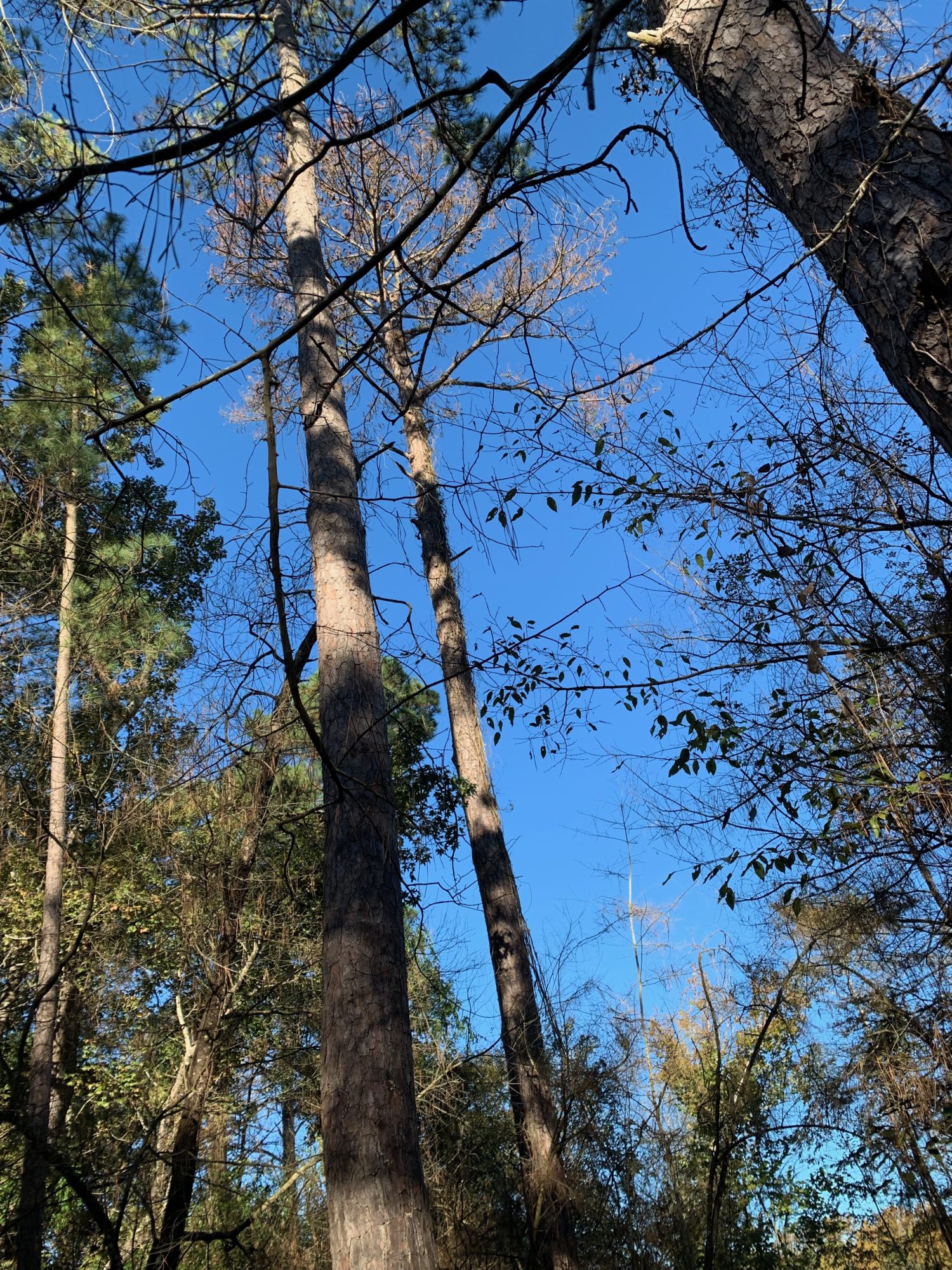
Forests come down to the river’s edge. Grasses and cattails abound, protecting the banks.

Dense forest anchors the land. Grasses, forced to compete for sunlight, thrive along the river’s edge, protecting banks.

A perfect time and place for reflection. A nice place just to “be.”

All images so far were taken on the East Fork of the San Jacinto River above where it merges with Caney Creek. Image courtesy of Google Earth.

Red lines on left measure width of East Fork on 3/3/16, before the Tax Day Storm. They are in a separate layer. Switching the background image to 10/28/17 shows that the river is virtually unchanged, thanks in large part to the lush riparian vegetation.

Now, A Trip up the West Fork

Now, let’s look at the West Fork. It’s vastly different.

Townhomes on Marina Drive in Forest Cove. Concrete, steel and wooden walls on the West Fork were less effective at preventing erosion than blades of grass on the East Fork.

Same area. Note steepness of banks where vegetation can no longer take hold, perpetuating cycles of erosion.

Remnants of concrete retaining wall.

Site of a breach in sand mine dike on the West Fork. The mine discharged sediment directly into the river.

Two weeks after Harvey. Just north of US 59 bridge.

West Fork Sand mine complex. Note one of many dike breaches in various mines that allowed sand and sediment to pour downstream. All helicopter images taken two weeks after Harvey on 9/14/17.

Mining a point bar after Harvey. Miners are supposed to work within their dikes to avoid disrupting vegetation along the river. Photo taken 9/14/17.

Note more repairs to dikes.

The next three images form a series.

River is migrating toward pit in background at the rate of 12 feet per year, in part, due to lack of vegetation protecting banks. See next two images before for overhead views.

This is what the area above looked like in a 1995 USGS aerial photo on Google Earth. Compare the location of the red line in this image with the location in the next image. The GPS coordinates of the line are identical. But the river has migrated.

 In just 23 years, the West Fork migrated 258 feet toward the dike on the right and now threatens it. The river has eaten away at the dike an average of 12.4 feet per year. The dike is now only 38 feet wide.

A bright white trail of sand leads all the way from the mines to the mouth bar which helped back water up into the highly populated Humble/Kingwood area. Fresh sand is several feet deep. Note absence of grasses. Many of the trees will also soon die.

Nearing the US59 bridge

Confluence of West Fork and Spring Creek, which also contributed sand to this event.

The next two images form a before/after pair.

West Fork of the San Jacinto over the US 59 Bridge before the Tax Day flood in 2016. River was 330 feet wide. Image courtesy of Google Earth.

GPS coordinates of the red line have not changed; the river has. After Harvey (in a little more than two years), the West Fork widened to 489 feet and shifted north by 113 feet. In part, this was due to excessive sediment that killed vegetation along the banks and accelerated erosion. Dead trees swept downriver were trapped by the bridge pilings, forming a dam that helped flood Humble businesses south of this photo. The southbound lanes of the bridge had to be replaced by TexDoT at a cost of approximately $20 million because of erosion. 

Union Pacific railroad traffic was disrupted for months.

Mountains of sand may kill the remaining trees in this area, exposing it to even more erosion during the next storm.

Sand, in part, from the mines, has almost totally blocked the West Fork where it meets Lake Houston. Before/after measurements show that as much as ten feet was deposited in this area during Harvey (approximately five feet below water and five above). This forms a dam behind the dam, that backs water up into the Humble/Kingwood corridor during storms. Unless this sediment is removed, a storm smaller than Harvey could create Harvey-scale flooding.

Tree Loss in East End Park Has Already Started

Acres of trees in Kingwood’s East End Park have already started to die back as a result of being buried in dunes 10-15 high. I believe that sand, in large part, from the 750-acre mine upstream on Caney Creek is causing this. Piling as little as six inches of sediment around the base of a tree can kill it.

Trees dying in Kingwood’s East End Park because of massive sediment build up around their trunks.

The website SF Gate describes how this die-back happens. “Soil added around a tree reduces the amount of oxygen available to the roots and slows the rate of gas exchange in and around the roots. There may be less moisture and nutrients available to the roots or too much moisture may remain around the tree’s roots. Inadequate oxygen reaching the roots or microorganisms in the soil around the roots can lead to an accumulation of chemicals that can injure tree roots. The tree’s bark may decay where soil is newly in contact with it. Damage or injury to the tree because of the added soil may not become apparent for several months or years and generally appears as a slow decline followed by death.” The same thing can happen with grasses and smaller trees along riverbanks. Once they die back and there is nothing left to bind the soil…

“Sediment is the primary pollutant expected from quarry operations.”

The Texas Commission on Environmental Quality says, “Sediment is the primary pollutant expected from quarry operations.” See page 22 of this 2012 report from the Texas Commission on environmental quality about the John Graves Scenic Riverway District on the Brazos.  The TCEQ also conducted experiments showing that certain types of revegetation can reduce sediment discharge from mines by 98 percent.

These findings are consistent with Louisiana Best Management Practice Guidelines for Sand Mines. They state that grasses can reduce erosion by 99%.

Conclusion

In the upcoming legislative session, the Lake Houston area needs to push for the creation of a river preservation district like the John Graves. The Graves District excludes sand mines from the 100-year flood plain and floodway where most erosion happens.

All Lake-Houston-area mines are in the FLOODWAY with the exception of one. A floodway is defined as the main channel of the river during a flood. This makes the mines more susceptible to river capture and massive erosion, which can create a downward spiral as we have seen above. Eventually it can lead to loss of property.

Our preservation district would stretch from Lake Conroe to Lake Houston, the primary sources of water for two million people.

The lives, health, homes, and businesses of two million people are certainly worth as much as protecting some scenery.

Posted by Bob Rehak on 12/1/18

449 Days after Hurricane Harvey