Dr. Charlie Campbell, a master of functional medicine, jogs 22 miles a week in East End Park. He tries to time his jogs so that he arrives at Otter Point every morning for moments like this.
Sunrise at Otter Point by Dr. Charles Campbell. Used with permission.
If that won’t make you feel good, you’re a spiritual crustacean.
Years ago, I remember meeting a man meditating at Otter Point almost every day. I asked him what he found in it. He told me his story. The man was on chemo, fighting cancer. He said that the natural beauty gave him sustenance and the will to keep on fighting.
East End Park does that for many people in many different ways. Especially Otter Point. Whether you’re a cancer survivor or a flood survivor. If you’re not familiar with the park and the place, you should be. They are rare ecological gems inside the fourth largest city in the country. And something worth fighting FOR.
As a postscript to this story, Dr. Campbell sent me another picture taken this morning.
Photo by Dr. Charles Campbell, used with permission.
If you want to get your kids interested in physics, ask them why sunrises and sunsets are red. Here’s the answer.
Posted by Bob Rehak on 11/21/2019, with thanks to Dr. Campbell and Mother Nature
814 Days since Hurricane Harvey and 63 since Imelda
https://i0.wp.com/reduceflooding.com/wp-content/uploads/2019/11/IMG_1341.jpeg?fit=1599%2C1199&ssl=111991599adminadmin2019-11-20 22:03:132019-11-21 10:45:09A Moment of Tranquil Splendor at Otter Point
While Imelda brought untold heartache and suffering to hundreds, it did have one bright spot.
Shortly before Imelda, KSA had the meadows mowed in East End Park. Since then, thanks to the heavy rains, a bumper crop of fresh new green grass has attracted large numbers of deer. The grass is already knee high. On my evening walk in the park tonight, we circled the large meadow and saw more deer than I have ever seen in one place in 35 years of living in Kingwood. We counted a total of four families and twenty deer in total: bucks, does, and fawns.
The best time for viewing deer, if you are so inclined, is near sunset.
Video courtesy of John Knoezer. Deer are pretty skittish. You probably won’t get closer to them than 20 or 30 yards. But it’s inspiring to watch such graceful creatures, even from a distance. Bring binoculars for the best viewing.Many deer will remain near the edge of the meadow where they can retreat into the forest if they feel threatened.
Why KSA Mows the Meadows
KSA mows the meadows occasionally to discourage the spread of invasive species and halt the spread of the forests into meadow areas. The meadows also provide grass seed for migrating species of birds in the fall and spring.
Even though KSA got a late start mowing this year, heavy rains from Imelda made the grass grow quickly. It has already started going to seed, ensuring that migrating birds will have a satisfying rest stop and that birders will have have one of the best seasons ever.
The deer this year? Purely a bonus.
Meadow Trails Still Passable
While flood waters destroyed trails and wetlands in other parts of the park, the main meadow near Kingwood Drive seems to have benefited. Meadow trails are still passable unlike other trails. And at sunset there is a refreshing breeze that seems to keep mosquitos away.
Three of 20 deer spotted in East End Park’s main meadow near sunset on 10/9/2019.Photo courtesy of John Knoezer.
Posted by Bob Rehak on 10/9/2019
771 Days since Hurricane Harvey and 20 since Imelda
https://i0.wp.com/reduceflooding.com/wp-content/uploads/2019/10/Deer-in-EEP.jpg?fit=1500%2C836&ssl=18361500adminadmin2019-10-09 21:36:582019-10-09 21:46:08One Bright Spot of Imelda
Below: the approximate locations of breaches for orientation purposes. All aerial photos taken on 10/2/19.
Approximate locations of eight breaches in the Porter Triple PG mine during Imelda.
Breach #1
Partial breach along Caney Creek in the northern section of the mine, looking south toward the mine’s ponds.
Breach #2
Another pond in the far northern area shows evidence of a breach and severe erosion. This shot looks northwest.
Breach #3
Looking NW from over the main dike that separates the main part of the mine from the northern area. The dike cuts from the upper left toward lower right and has a massive breach. The angle of the downed trees suggests that Caney Creek overflowed on the north, swept through all the ponds to the north and then broke into the mine through this breach.
Breach #4
Partial breach. Hovering over Caney Creek in the foreground, looking west into the pit.
Breach #5
Hovering over Caney Creek in the foreground, looking west into the pit.This breach was opened in May and never closed properly.Same breach, but photographed from the reverse angle. Hovering over the pit, looking east toward Caney Creek.
Breach #6
The southern dike of the mine is behind these trees. It obviously didn’t hold back water sweeping through the mine. It pushed these fences in from the north toward the south.Photo taken 10/6/19.Many homes immediately below the mine flooded also. The so-called dike that runs along the southern edge of the mine is really flush with the ground level in this area.Photo taken 10/6/19.
Breach #7
Hovering over the pit looking toward the west dike of the mine and White Oak Creek, which breached into the mine.Reverse shot. Looking east into the mine from over White Oak Creek.
Breach #8
The mine’s main stockpile sits on the western side of the mine. Rain seems to have washed much of it into the creek below the dike.
Direction of Flow
Note additional erosion to main stockpile. It sits at the confluence of two floodways: Caney Creek’s and White Oak Creek’s. You can see the influence of those two creeks in the erosion. This shot faces west. Caney Creek came in from the north (right to left). White Oak Creek came in from the west (top middle to left middle). Note the sand pushed up against the building.See close up below.Sand pushed up against northern edge of building indicates the main flow came from the north…Caney Creek.
Sand Clogging River
Much sand now clogs the river that wasn’t there before Imelda. No doubt, some sand came from river bed and bank erosion. But it’s hard to believe that none of it came from the Triple PG Sand Mine, which sits in two floodways and whose dikes breached in at least eight places.
The shot below looks across the northeastern section of Riverchase. Many homes flooded in this area. When you look at the river, you can see a possible contributing factor: giant sand bars that consume two-thirds of the width of the river.
The breaches, the sand clogging the river, and the flooded homes all argue for moving mines back farther from rivers. Texas is the only state that has no minimum setbacks for mines. During Imelda, the East Fork and its residents paid the price for that policy.
Northeastern Riverchase, where several homes flooded near the river. Note giant sand bars just beyond the trees.Residents have commented on all the sand in streets. East End Park lies to the right of the giant bar. It also suffered from massive sanding during Imelda, in the area immediately opposite the bar.A reverse shot of this bar shows that it is not only wide and long but tall. It reaches into treetops.The helicopter was hovering over East End Park for this shot and the camera is looking north.
Altogether, I took almost a thousand shots from the air last Wednesday along the East Fork between 99 and Lake Houston and from Lake Houston up the West Fork to the Woodlands. More findings in future posts.
Posted by Bob Rehak on 10/6/2019 with help from Josh Alberson and Charlie Fahrmeier
768 Days since Hurricane Harvey and 17 since Imelda.
All thoughts in this post represent my opinions on matters of public interest and safety. They are protected by the First Amendment of the US Constitution and the Anti-SLAPP statute of the Great State of Texas.
https://i0.wp.com/reduceflooding.com/wp-content/uploads/2019/10/Homes_001.jpg?fit=1500%2C1000&ssl=110001500adminadmin2019-10-06 22:45:532019-10-06 22:48:34More Breaches Discovered at Triple PG Sand Mine; Implications for East Fork Flooding
At its monthly meeting, members of the KSA Parks Committee voted unanimously to approve $60,000 to begin emergency repairs to East End Park immediately. The vote followed a presentation by Bob Rehak (me), Park Steward; Dee Price, KSA President; and Maryanne Fortson, KSA Secretary and President of Fosters Mill.
Safety Concerns Jumpstart Repairs
The presentation detailed damage by Imelda and historic East Fork flooding that put most of the park under water during the tropical storm. Much of the discussion focused on safety concerns following a review of photos taken from land, boat and helicopter, including those below.
Pelican Overlook Trail consumed by erosion from river during Imelda.Same scene from river shows undercut banks. People standing near river could trigger dangerous cave ins.More trail erosion in East End Park. The river migrated approximately 50 feet south consuming large parts of two trails.
The photos (including those above) showed significant bank erosion to the northern shoreline of the park. The river undercut two trails as it migrated south about fifty feet during the storm. Parts of two trails fell into the river: the Pelican Overlook and Eagle Point Trails.
Photos (above) taken from Josh Alberson’s boat show significant undercutting of the shoreline in those areas. That means, someone standing on the edge could trigger a cave in.
KSA has tried to close the park three times, but people keep tearing down the warning signs.
Options Discussed but NOT Included in Emergency Repairs
As part of the discussion on the motion, the Committee examined several alternative solutions to restoring the park to full functionality.
A short new trail (further inland) will reconnect the two parts of the severed Pelican Overlook Trail.
Fallen logs will block off the parts of the existing trail in danger of caving into the river. Metal signs will be screwed into the logs warning people of dangers ahead.
KSA will abandon the Eagle Point Trail and rename it the “Dunes Area” of the park. Residents can still access the Dunes Area, but no trails will run through it. This will reduce current and future repair and maintenance costs; repairing that area consumed a large portion of the budget after Harvey. The dunes should offer a new experience for park-goers, especially those who like climbing or hiking in sand for cardio workouts.
As a separate project (not included in the $60,000), KSA will explore the cost of building a new trail that connects the South Loop and Pelican Overlook trails without going all the way back to the main entry trail. It would go to the south of the “overflow channel” that carries floodwater through that section of the park and would not require bridges.
Also as a separate project, KSA would compare two options for replacing a portion of the South Loop trail. The portion – between Heron’s Rest and the turn-off to the main boardwalk – turns into mud after every flood. The mud comes from several inches of silt deposited on TOP of the crushed granite trail. The first option: relocating the trail atop a berm that parallels the current trail about 50 feet further inland. The second option: replacing the current trail with a low boardwalk, like the ones near Alligator Alley.
Dunes Area Will Revert to Nature
This birds’ nest used to be the height of a basketball hoop. After Imelda, it’s ankle high.Photo by John Knoezer.
Emergency Repairs Will Include…
The Parks Committee appointed Rehak, Fortson and Price as a subcommittee to approve emergency repair costs, rather than wait another month for the Parks Committee to meet again. Included in the emergency repairs:
Tree removal, where necessary
Patching trails scoured by the flood to create a stable hiking and jogging surface
Resurfacing most muddy areas with crushed granite
Boardwalk repairs
Restoring the telephone poles in the parking lot to their original positions
Replacing trail underliner on hills with gravel to create a more stable base for crushed granite. The latter will form the top finished surface.
Erecting barricades and signs warning of hazardous conditions where the river undercut existing trails
Cleaning all boardwalks and benches
Removing all flood debris from trails.
Restoring An Ecological Gem
An estimated 70,000 to 80,000 visitors per year use East End Park. It is an ecological gem, valued as much for the 150 bird species that migrate through the park and a herd of deer that lives in the park year round, as for the quiet, restorative atmosphere that bonds families together on nature walks.
Five area cross country teams also use the park for practice. Joggers value the soft surface of crushed granite. It’s much easier on knees and backs than concrete.
East End Park is also one of the few dog-friendly parks in the City of Houston. Different people like the park for different reasons. It has so much to offer.
I remember one time, seeing a man sitting at a new bench in a particularly beautiful part of the park. He came day after day to walk in beauty and meditate on nature. One day, I asked him what he got out of it. It gave him the motivation, he said, to cope with chemo.
The poster below shows how the park looked then and how it will soon look again.
What East End Park looked like BEFORE Imelda.
Posted by Bob Rehak on 10/3/2019 with gratitude to Josh Alberson, John Knoezer, Dee Price, Maryanne Fortson, National Helicopter Service and the entire KSA Parks Committee
765 Days since Hurricane Harvey and 14 since Imelda
https://i0.wp.com/reduceflooding.com/wp-content/uploads/2019/10/EEP_001_23.jpg?fit=1500%2C1000&ssl=110001500adminadmin2019-10-03 23:50:352019-10-03 23:50:44KSA Approves $60,000 to Begin Emergency Repairs to East End Park Immediately
In the 2+ years since Hurricane Harvey, many East Fork residents complained that the West Fork was getting all the media attention and remediation dollars. Imelda may have just changed that narrative. An East Fork Mouth Bar rapidly increased in size during the storm.
Rapid Increase in Sedimentation Between Royal Shores and Luce Bayou
Between Luce Bayou and Royal Shores, Josh Alberson, an East Fork resident and boater says the channel recently measured as much as 18 feet deep. Last weekend, when checking cross-sections on the depth finder of his jet boat, the deepest part of the channel measured three to four feet in that same area. Here’s what it looks like from a helicopter pointing south toward Lake Houston and the FM1960 Bridge.
East Fork Mouth Bar. Photo taken one week after Imelda on 9/27/19.
It’s clear that portions of these bars preceded Imelda, just as portions of the West Fork Mouth Bar preceded Harvey. You can tell that by the vegetation. However, you can also see the immense recent growth of these bars in the areas without vegetation.
Shots taken from the boat show vast expanses of sand now clogging the East Fork.
Looking south toward the entrance to Lake Houston.Photo taken on 9/29/19.Channel between here and Luce Bayou (out of frame on the left) averaged 3-4 feet deep.Looking west toward Royal Shores from same location. Photo taken 9/29/19.Looking east toward Luce Bayou, I captured this shot of a dead tree on 9/29/19. It underscores how shallow the river is at this location. More than half the root ball sits above water.
Hundreds, Possibly Thousands of Trees Down
Upstream, hundreds, if not thousands of trees were uprooted by Imelda. The City and DRC had just completed removing such hazards. They did a thorough and beautiful job. However, Imelda will mean starting over…at least on the East Fork.
Giant Sand Bars Now Filling More than Half of River
The sand bar opposite East End Park migrated downstream. It also expanded outward and may have contributed to significant erosion on the parks northern shore. It now cuts off more than half the river. Not surprisingly The river appears to have migrated south in this area by at least 50 feet.Opposite the massive sand bar above, entire trails have been washed away in East End Park. Beware of possible bank collapse. Very dangerous conditions exist on trails. Do not use the park until repairs have been completed.The storm deposited other sand bars father upstream, like this one in the approximate area of Woodstream. It was just below where Taylor Gully enters the river at Dunham Road.
Fourth Breach Discovered at Sand Mine
Still unknown: how much of a role multiple breaches at the Triple PG mine played in sedimentation.
View of partial breach near north end of Triple PG mine from Caney Creek. Photo by Charlie Fahrmeier. Taken on 9/30/19. Above the partial breach shown in the photo above. Fahrmeier says he found the grass all laying down in one direction indicating rushing water inundated it recently. Photo taken on 9/30/19.
Role of Sand Mine Under Investigation
Dan Huberty today announced that Ken Paxton, the state attorney general, has agreed to investigate the Triple PG mine. A spokesman for the federal Mine Safety and Health Administration said investigators were headed to the site today. The TCEQ has also launched an investigation.
Clearly, the mine is not responsible for all of the sand in the river. But its location in TWO floodways, four possible breaches, and loss of a major portion of its stockpile indicate it played some role in the massive sedimentation.
Looking south across the Triple PG Mine’s main stockpile. White Oak Creek swept in from the right and Caney Creek from the left. The stockpile measures approximately 20 acres and has risen to an estimated 90-100 feet at times. On this day, 9/27/19, it was much smaller. Whether that was due to erosion or sales is unknown.Notice all the equipment laying on its side to the right of the metal buildings.
Substantial Repairs?
After a breach in May, the mine simply dumped sand in the hole which quickly eroded again. Photo taken 9/29/19.
I doubt this meets the TCEQ requirements for substantial repairs.
Close up of breach repair. It appears to be nothing but sand.Photo 9/29/19.
Whether these repairs were intended to fail or whether the operator didn’t care if they failed, the result was the same. More sand in the river. And more gunk in your drinking water supply.
Posted by Bob Rehak on 10/2/2019with thanks to Josh Alberson and Charlie Fahrmeier.
764 Days after Hurricane Harvey and 13 since Imelda
All thoughts expressed in this post represent my opinions on matters of public policy and safety. They are protected by the First Amendment of the US Constitution and the Anti-SLAPP statute of the Great State of Texas.
https://i0.wp.com/reduceflooding.com/wp-content/uploads/2019/10/MouthBar9.27.19_1500dpi.jpg?fit=1500%2C1000&ssl=110001500adminadmin2019-10-01 21:38:002019-10-01 22:06:53East Fork Mouth Bar Rapidly Developing
Of all the sand mines on the East and West Forks of the San Jacinto, the Triple PG Mine is unique. It alone sits inside the confluence of TWO floodways. The Prabhakar Guniganti family owns the mine. So far they have cleared, grubbed and mined about 700 of the 2000 acres they own in the area. But that hasn’t stopped them from receiving timber exemptions from the Montgomery County Appraisal District on the land being mined (that has no timber).
After Harvey, when I found 30 acres of sand up to 15 feet deep covering East End Park (just downstream from the mine), I rented a helicopter to see where the sand came from. That’s when I discovered this horrific mine for the first time.
Last week, Charlie Fahrmeier, a Lake Houston Area resident and an expert in sediment control, observed the same breach open AGAIN. Right above East End Park, which was destroyed by sand AGAIN.
So Friday, I rented another helicopter to see what I could see. What I saw turned my stomach. There was more than one breach. There were at least two and possibly three.
It appeared that Caney Creek (from the north) and White Oak Bayou from the west “captured the pit.” The streams then apparently crossed the mine sweeping out through the breach on the southeast side back into Caney Creek and then down the East Fork of the San Jacinto River.
White Oak Creek approaches the mine from the west and Caney Creek runs along its north and east sides. From the images below, taken a week after Imelda, it appears that the both creeks captured the mine and cut across it.From FEMA’s National Flood Hazard Layer Viewer.
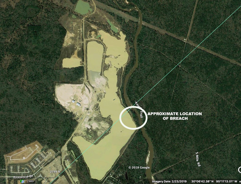
Where Breaches Occurred
The TCEQ fined Triple PG $16,875 for breaches one and two that were first reported after the May 7th storm. TCEQ has opened another investigation into the most recent breaches. Fines could be more substantial this time.
Three Breaches from the Air
Looking north from over the pit toward Caney Creek out of frame on the top. Water likely entered the mine from the north as Caney Creek reached flood stage and cut across the point bar above the mine. Taken 9/27/19.
A reverse shot shows how water tore through the mine.
Looking south from over Caney Creek, you can see how current ripped through the mine. The road across the mine in the middle of the frame had been recently repaired when I took this shot on 9/27/19.At the far end of the shot above on the west (right) side of the mine, I found this breach near White Oak Creek.Taken 9/27/19.Looking east, directly across the mine, I saw this breach in the same location as the May breach. That’s Caney Creek in the background.Taken 9/27/19.This close up shot of the same breach looking west from over Caney Creek shows how flimsy the repair was from earlier in the year. It was nothing but some sand dumped into a hole.Taken 9/27/19.
Designed to Fail?
Two engineers told me that patch looked like it was “designed to fail.” Mine Safety and Health Administration regulation §56.20010 regarding retaining dams specifies that “If failure of a water or silt retaining dam will create a hazard, it shall be of substantial construction and inspected at regular intervals.” Clearly, sand is not substantial. “Built properly, that repair would not have reopened in this past flood,” said Fahrmeier.
TCEQ Requirements for Dike Construction and Repairs
Here are the TCEQ requirements for constructing dikes and levees. Note the paragraph on page 2 about structural integrity. “Construction must be based upon sound engineering principles. Structural integrity must withstand any waters which the levee or other improvement is intended to restrain or carry, considering all topographic features, including existing levees.”
These dikes had the structural integrity of a sand castle at a beach when the tide comes in.
Also interesting: Paragraph 4, Rights of Third Parties to be Protected. It’s a good read as far as regulations go.
Certainly, East End Park, just downstream was not protected.
KSA just finished cleaning up East End Park from Harvey. The organization spent close to $200,000 to restore trails covered in sand that reached to the treetops. Now the entire Kingwood community will have to sacrifice again. This area used to be a boardwalk over wetlands. The sign used to be shoulder high. Now it’s knee high.
Another trail covered in sand and silt. Not all of this came from the mine; some came from river erosion. But the serious problems first appeared after the mine.
How to Tell Mine from River Sedimentation
Charlie Fahrmeier who first discovered the most recent breach said that when he discovered it, water and sediment was streaming out of the mine. The water color was distinctly different from the color of water coming down Caney Creek. If the creek were responsible for all the sedimentation, the colors would have been reversed.
Caney Creek Now Averages 1.7 Feet Deep
In a future post, I will examine the growing mouth bar on the East Fork. That’s right. The East Fork and Caney Creek are barely navigable now. John Alberson took his jet boat up Caney Creek today and noted giant sand bars stretching across the river below the pit. He said the deepest part of the creek was 1.7 feet. The more sand there is in the creek and East Fork, the less room there is for water, so the higher the water rises during a flood.
How to File a Complaint With Mine Safety Authorities
Mine is in two zip codes but breaches appear to be in 77365.
Location of Breach #1: Long 30.102968°, Lat -95.171932°
Location of Breach #2: Long 30.055360°, Lat -95.104712°
Location of Breach #3: 30.065451°, Lat -95.102904°
Please help shut this mine down. It’s dumping its process water loaded with sediment and chlorides into your drinking water. Moreover, the City doesn’t have enough money to dredge the East Fork and its tributaries every time we get a big rain. Let’s stop this problem at the source. We need sand for concrete, but we don’t need it from this mine.
Posted by Bob Rehak on 9/29/2019
761 Days since Hurricane Harvey
The thoughts expressed in the post represent my opinions on matters of public interest and safety. They are protected by the First Amendment of the US constitution and the Anti-SLAPP statute of the great State of Texas.
https://i0.wp.com/reduceflooding.com/wp-content/uploads/2019/09/TripePBreach.jpg?fit=1500%2C1000&ssl=110001500adminadmin2019-09-29 01:04:202019-09-29 08:44:35Triple PG Mine Dikes Breach in Multiple Places, Contributing to Giant East Fork Sand Buildups
Correction: The head of Enforcement for the TCEQ notified me that there was a “proposed” fine of $16,875 issued to the Triple-P Mine for the May breach, but that they have not “settled” yet.
The East Fork of the San Jacinto River and the Triple-P sand mine took a terrible toll on Kingwood’s East End Park for the second time in two years during Imelda. Sand several feet thick blanketed about 30 acres of this beautiful ecological gem and the peaceful trails that wind through it. The devastation matched and in some cases surpassed Harvey’s. These pictures tell the story. After Harvey, it took hundreds of thousands of dollars to restore the trails and boardwalks in the park. It will cost at least that much again.
Carried Away
This bench on the Pelican Overlook Trail used to have about 50 feet of trail, trees and river bank in front of it. Imelda eroded the bank and the river cut away the land under the trail. The trail will now have to be moved inland. It no longer exists.
Blanketed by Sand
This boardwalk to Eagle Point used to go over pristine wetlands. It will now require excavation.Photo courtesy of John Knoezer.
Scoured by Flood Waters
Trail scouring occurred in many places. Large parts of the North Loop trail will require replacement.Photo courtesy of John Knoezer.
Taking Destruction to New Levels
This sign used to be chest high. Now it’s knee high.Photo courtesy of John Knoezer.
Giant Trees Uprooted
Trees are down in multiple places and block the main boardwalk. Photo courtesy of John Knoezer.
Covered Up
The main boardwalk is covered with a layer of ultra-slippery silt 1-2 inches thick. Photo courtesy of John Knoezer.
Under Water
In many places, trails have gone underwater.At this location, we found quicksand. See below.
Quick Sand
Rika, the safety pup, says, “Hmmmm. Lucky I don’t have to buy shoes.”
For your own safety and the safety of your shoes, do not venture into the park near the river. It’s dangerous as you can see. Quicksand even exists in some places.
Now for The Bad News
Much of this sand may have come from the Triple-P sand mine on Caney Creek, just upstream from East End Park.
Image courtesy of Charlie Fahrmeier, an expert in turbidity control. Photo taken on 9/22/2019.Image of same breach on May 17th.Location of Breach
Once again the mine breached its dike, underscoring the danger of locating mines in floodways. This particular mine sits at the confluence of two floodways: Caney Creek and White Oak Creek. During Harvey, it lost a major portion of its stockpile to floodwaters. Then it happened again.
It appears that Triple P dumped some sand in the breach in a feeble attempt to stop the hemorrhage. But it obviously did not hold for long. Fahrmeier, who discovered this latest breach on his Waverunner, is an expert in turbidity and environmental pollution control. He said that sand is the wrong type of material for repairing dikes and that the repeat blowout was predictable.
Fahrmeier said that as he was coming up Caney Creek, the stream of sediment coming from the mine made it look as though there were two different streams. “There’s still quite a bit of sediment flowing into the river as evidenced by the discoloration. The pit is pretty large and no doubt contributed a significant volume of water and sediment flowing into Lake Houston since last week.”
KSA Repairs
KSA will begin initiating repairs on East End Park quickly. But many parts of the park are still not accessible. It may be months before all this damage can be repaired. In the meantime, please limit use of the park to the higher parts unaffected by Imelda and Triple P. No doubt some of this sand comes from river bed and bank erosion. But I believe a lot came from the mine, too. I hope KSA decides to sue the mine this time. It’s clear that they do not fear the TCEQ.
Posted by Bob Rehak on 9/23/2019 with images from John Knoezer and Charlier Fahrmeier
756 Days since Hurricane Harvey and 5 since Imelda
The thoughts expressed in this post represent my opinions on matters of public policy and safety. They are protected by the First Amendment of the US Constitution and the Anti-SLAPP Statute of the Great State of Texas.
https://i0.wp.com/reduceflooding.com/wp-content/uploads/2019/09/Overlook-Washout.jpg?fit=1500%2C2000&ssl=120001500adminadmin2019-09-23 21:00:282019-09-25 14:53:10Triple-P Sand Mine Breached Again; East End Park Destroyed for Second Time in Two Years
Since Harvey, I’ve been talking about the dangers of sand mining too close to the river. Texas is the only state I can find that has no minimum setback for mines. Tony Buzbee, candidate for Mayor of Houston, asked to see what I was talking about. So a friend, Josh Alberson, took us on out his jet boat this afternoon.
Massive Breach in Mine Dike
As luck would have it, we went up Caney Creek. Just above where it enters the East Fork, we spotted a massive new breach in the dike of the Triple-P mine. Here’s what we saw.
Looking into the Triple-P Mine through a breach in its dike on Caney Creek
Note the exposed shoreline in the background indicating how much water the mine lost to the river.
Looking 180 degrees from the shots above. The tree leaning over at a ten degree angle from the river is on the far bank of Caney Creek.
This shows how wide the breach is in relation to the boat. The boat is 22 feet long.
This shot taken from the boat shows the mine’s cleaning, sorting and transportation equipment in the background. I could not see the dredge operating in the mine’s pit from this angle.
This Google Earth image shows the approximate location of the breach. The blue diagonal line is the Harris/Montgomery County Line. Caney Creek connects up with Lake Houston to the south (bottom part) of this image. Mmmmmmm. That water looks delicious, doesn’t it. If you get your water from Lake Houston, you’re drinking it!
Tony Buzbee, examining the sand bar at the bottom of the shot above (below the mine). The bar has grown in size, according to Alberson, a regular East Fork boater. This illustrates the danger of sand mining so close to the river. Buzbee also visited the mouth bar on the West Fork during his river tour today.
Mine Has History of Problems
I previously posted about breaches in this mine’s dikes and the loss of a major portion of its stockpile during Harvey. The stockpile is located in the confluence of two floodways (Caney Creek and White Oak Creek). Partially as a result of this mine, Kingwood’s East End Park just downstream was inundated with sand and gravel up to 15 feet deep after Harvey. Repairing damage to the trails in the park cost Kingwood residents almost $200,000. The wetlands have been lost forever.
Wetlands no more. Eagle Point in East End Park is drowned in sand from the Triple-P mine. It washed downstream during Harvey.Massive sediment deposits in the San Jacinto have also been linked to flooding by the Army Corps of Engineers.
If you are a sand miner, having Tony Buzbee witness this breach and the massive sedimentation it caused downstream is a nightmare scenario. Not only is Buzbee running for Mayor of Houston, he’s self-funding his campaign. That means he does not depend on TACA contributions. And worse (or better if you are a resident), he’s one of the top litigators in the world. In 2015, he was named Texas lawyer of the year. Kingwood residents can only hope he takes up this cause.
TCEQ Already Investigating
Upon returning home from the boat trip, I immediately notified Ramiro Garcia, head of Compliance and Enforcement for the TCEQ (Texas Commission on Environmental Quality) about the breach in the dike. Garcia says they have people already on the case. I hope they choose to yank this mine’s license and make it an example. At a minimum, I believe they should give the mine the maximum fine. My understanding is that the fine can run up to $25,000 per day. This kind of flagrant violation endangers the health of millions of people and deserves no less.
As a result of the problems created by sand mining in the San Jacinto River watershed, State Representative Dan Huberty sponsored a bill this year to establish best practices for the mines. HB 909 was referred to the Environmental Regulation Committee on 2/25. The committee heard testimony on 5/1. TACA testified AGAINST establishing and publishing best practices. HB909 has been bottled up in committee ever since.
Please use this breach to try to get the legislation out of committee. This is major. It affects the drinking water supply for 2 million people. I talked about the dangers of mining too close to rivers when I testified for HB909. These miners just don’t care. They think that their ability to make a profit is more important that your health. Please send a message to Austin. Refer the members of the Environmental Regulation Committee to this post and tell them this is what Rehak testified about on 5/1. Have them vote it out of committee. Let’s establish best practices for sand mining in Texas. While we still can.
Here are the members of the Environmental Regulation Committee.
J.M. Lozano (Chairman) (512) 463-0463
Ed Thompson (Vice Chair) (512) 463-0707
Cesar Blanco (512) 463-0622
Kyle Kacal (512) 463-0412
John Kuempel (512) 463-0602
Geanie Morrison (512) 463-0456
Ron Reynolds (512) 463-0494
John Turner (512) 463-0576
Erin Zwiener (512) 463-0647
Please call their office and ask them to vote HB 909 out of committee. Tell them this breach is the great example of why we need this bill. Breaches like this happen far too often. There are only ten days left in this session.
Posted by Bob Rehak on 5/18/19, with a big thank you to Josh Alberson and Tony Buzbee
627 Days since Hurricane Harvey
All thoughts expressed in this post represent my opinions on matters of public policy and are protected by the First Amendment of the US Constitution and the Anti-SLAPP statute of the Great State of Texas.
https://i0.wp.com/reduceflooding.com/wp-content/uploads/2019/05/Mine-Breech.jpg?fit=1500%2C1000&ssl=110001500adminadmin2019-05-17 21:23:342019-05-17 23:15:52Nailed: Triple-P Sand Mine Photographed Discharging Wastewater Directly into Lake Houston Tributary
During this recent flood, the East Fork crested after the West Fork – because of where heavy rain fell upstream. This morning, ABC13 posted a story about how FM1485 in New Caney was under water from East Fork flooding.
Otter Point in East End Park at dusk. This deck is normally about 4 feet above lake level. Photo by John Knoerzer.
Tonight, a friend, John Knoerzer, texted this photo to me from Otter Point at East End Park. In case you didn’t know, East End Park is on the East Fork of the San Jacinto. John runs a heating and air conditioning company called UniServe. He’s a great AC guy, but never claimed to be a photographer. Nevertheless, the composition of his photo above almost feels like art.
People familiar with this site will recognize that despite releasing water for days, water is still 4 feet above the normal level and that the East Fork was on the verge of coming out of its banks in the Kingwood area. In fact, it did in some low lying areas.
Once again, I am reminded how very different this flood could have been for many people if the City had not lowered the lake for several days before the rain came. They not only lowered it the announced 18″, they kept lowering it as the flood built. Despite all that, it was a close call.
Close Call Underscores Need for Additional Gates
The frantic efforts to lower the lake underscore how important additional gates are for the Lake Houston Dam. The City needs the ability to shed water faster before it reaches the height of the spillway. With greater capacity, operators can reduce uncertainty associated with pre-releasing water…by waiting until storms are closer and forecasts become more certain. Operators can then be confident that they are not wasting precious water.
Weather forecasts can be notoriously fickle. And in fact, this one did not drop rain where predicted. Nor did it drop as much as predicted. Still, many areas were on the verge of being submerged as you can see from the photos above and below.
Parks are meant to be flooded. Fuel tanks? Not so much.
Kudos for Houston City Council Member Dave Martin for leading the charge in the effort to get the City to pre-release water.
U.S. Army Corps of Engineers’ command post for emergency dredging almost had an emergency of its own. Another foot higher and the site would have flooded. Photo taken Saturday afternoon, the day after the heavy rain.
Posted by Bob Rehak on 12/11/2018
469 Days after Hurricane Harvey
https://i0.wp.com/reduceflooding.com/wp-content/uploads/2018/12/IMG_0077-2.jpeg?fit=1200%2C900&ssl=19001200adminadmin2018-12-11 20:52:592018-12-11 20:58:30Getting Close to Nature. Maybe too close!