HFD high water rescue truck trying to save Kingwood homeowners on May 7th.Perry Home’s subsidiaries and Revel Contractors are now suing the victims.
Posted by Bob Rehak on 6/28/2019
668 Days since Hurricane Harvey
Thoughts expressed in this post represent my opinions on matters of public policy. They are protected by the First Amendment of the US Constitution and the Anti-SLAPP statute of the Great State of Texas.
https://i0.wp.com/reduceflooding.com/wp-content/uploads/2019/05/Rescue-Truck-1.jpg?fit=1500%2C729&ssl=17291500adminadmin2019-06-28 19:42:502019-06-28 19:42:58Tribune Story about Elm Grove Flooding Says Defendants Now Suing Flood Victims
The last three posts on the equity flap have focused on how minority neighborhoods in Precinct 1 already receive more flood mitigation funding than affluent areas like Kingwood. Tonight, I focus on why that is likely to continue for the foreseeable future. But first, a recap for context.
Biggest Beneficiary of Funding Claims Discrimination
Last Tuesday, the equity flap erupted again in Harris County Commissioners Court. Precinct 1 Commissioner Rodney Ellis complained that because of historical discrimination (i.e., slavery, which was abolished more than 150 years ago), he needs to fight for “equity” in the distribution and implementation flood bond projects. Precinct 1 already receives the lion’s share of many types of funding.
What Mr. Ellis does not point out to the Commissioners Court is that Precinct One:
When talking about “historic discrimination,” Commissioner Ellis needs to shift his focus forward in time and look at other areas of the county that receive NO such joint projects and far fewer flood mitigation dollars. Take the San Jacinto Watershed, for instance. It contains Kingwood. Because of Kingwood’s affluence, it’s one of the favorite whipping boys for Commissioner Ellis and his surrogates who argue for equity. They keep bringing equity up every time a Kingwood-related item is on the Flood Control agenda at commissioners court. But the Kingwood/Lake Houston Area has NO such joint projects. Why?
Causes of Inequity
There are two reasons for this inequitable distribution: one obvious, one not so.
First, the obvious: The Houston region has grown from the downtown area outward. Precinct 1, which includes downtown, is older. Flood problems became apparent sooner. Precinct 1 documented problems, identified solutions, and rallied Federal support decades ago.
Commissioner Ellis’ predecessors also started this process decades ago and Precinct 1 enjoys the rewards today. As a consequence…
Buffalo Bayou and all of its tributaries are eligible for Corps support on non-emergency projects; the San Jacinto is not.
The Corps is working on Buffalo Bayou and all of its tributaries thanks to legislation passed years ago. The Cypress Creek watershed actually overflowed into the adjoining watershed during Harvey.For a complete Corps presentation on Buffalo Bayou and its tributaries, see this link.
Even though the problems in the Lake Houston Area have been building for decades, the danger didn’t become apparent until Harvey.
At this point, rallying the kind of Federal support that Precinct 1 has historically enjoyed will involve an act of Congress and Presidential approval. Literally. That’s an uphill battle compared to the battle that Mr. Ellis’ projects face.
Political Challenges for San Jacinto Watershed
A local sponsor, such as the City, would have to file an application for a project. Congressional representatives would have to get the President to build it into the annual budget, then include it in the Water Resources Development Act. Both houses of Congress would have to pass the act. The President would have to sign it. And then the government would have to distribute the money. The distribution usually happens in phases, after approval of each phase of a project, such as:
Feasibility study
Engineering and design
Construction, operation and maintenance
Changes after construction authorization
Changes after construction
It could easily take three to five years just to get the engineering and design phase on a project, such as additional flood gates for Lake Houston.
A second challenge: Mr. Ellis and his surrogates using unfounded “equity” arguments to further handicap and delay flood mitigation in the Lake Houston Area.
Damages in Lake Houston Area
Unfortunately, the sedimentation and conveyance problems on the San Jacinto only became apparent after decades of additional upstream development. That exacerbates flooding by funneling water to the river faster. In recent years, Conroe was the fastest growing city in America.
Then along came the Tax Day, Memorial Day and Hurricane Harvey floods. They deposited an estimated 5 to 10 million cubic yards of sediment in the East and West Forks. Much of that came from sand mines upstream of Lake Houston, which Lake Conroe inundated when it released 80,000 cubic feet per second at the peak of the storm. This further exacerbated flooding by backing water up in the river and drainage ditches.
Citing historical discrimination that goes back to pre-Civil-War days, Mr. Ellis argues for equity to increase his precinct’s share of flood mitigation dollars and to accelerate projects in his precinct.
As the data shows, his precinct already has far more than its fair share of mitigation dollars. Now, he threatens other areas, property and lives by delaying and usurping their aid.
If any area is underfunded and fighting discrimination now, it’s the Lake Houston Area. Ironically, the discrimination is coming from the Rodney Ellis’ of the world.
I don’t begrudge Precinct 1 a penny of the flood mitigation funds it has received to date. And I admire Mr. Ellis for fighting so hard for his constituents. However, I despise the way he does it.
Mr. Ellis represents one fourth of the people in the county. Yet he cries “equity” and ignores facts to usurp more than half of flood mitigation funding and put his Bond projects at the front of the construction line. I wish he would acknowledge:
The inequality that exists in current funding and that is likely to continue for years.
That a Kingwood, Humble, Atascocita or Huffman life is as valuable as a life in Precinct 1.
Facts.
Ironically, the Lake Houston Area argued for equity in the bond language to prevent the very kind of reverse discrimination that we are now seeing. We need to work together to mitigate flooding everywhere as quickly as we can. This equity flap is fanning racial flames that divide us, perpetuate distrust, delay mitigation, and threaten lives. It’s time to get on with the hard work at hand. Two wrongs don’t make a right.
Posted by Bob Rehak on 6/28/2019
668 Days since Hurricane Harvey
https://i0.wp.com/reduceflooding.com/wp-content/uploads/2019/06/BBT.jpg?fit=1500%2C971&ssl=19711500adminadmin2019-06-27 23:07:522021-07-29 16:17:10Where the Flood Mitigation Dollars Have Really Gone: Part 4
Yesterday, the equity flap continued in Harris County Commissioners Court. Surrogates for Precinct 1 Commissioner Rodney Ellis again took the podium to talk about how affluent neighborhoods deprived low-to-moderate neighborhoods of flood mitigation dollars. The argument they use: FEMA prefers buying out high dollar homes to reduce repetitive flood insurance losses.
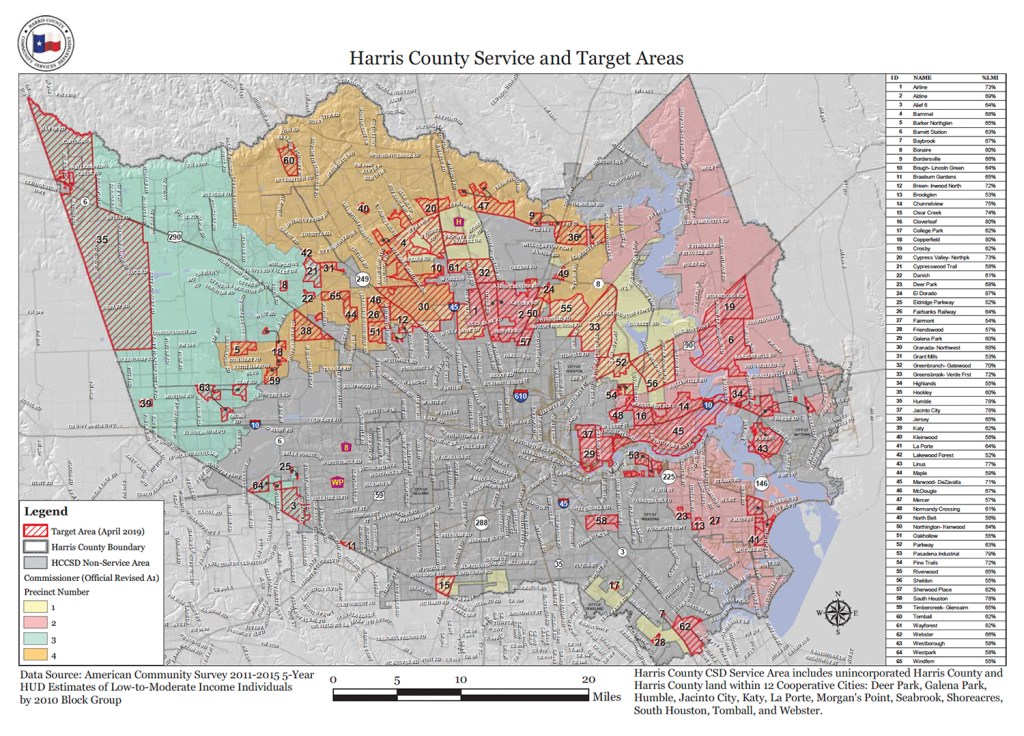
Low-to-moderate-income neighborhoods by precinct in Harris County.
Harris County has four precincts; each has roughly the same number of people. In an equitable world, you would expect roughly 25% of the buyouts to be in each district. If there really is a “buyout bias” against low income neighborhoods, you would expect Precinct 1 to have less than 25%. But it doesn’t.
Precinct 1 Gets More Than Its Fair Share of Buyouts
Under the Freedom of Information Act, I requested the number of buyouts in Precinct 1 and other precincts since 2000. Once again, hard data contradicts the self-serving myth. Since 2000, when buyouts began in Precinct 1, HCFCD bought 955 homes in Precinct 1 and 2,413 homes in other precincts.
Precinct One has slightly more than its fair share of buyouts.
So where’s the discrimination in buyouts?
HCFCD is buying out homes faster than ever. To learn more about their process, visit this page. With FEMA funds from Harvey, HCFCD hopes to buy out 1,100 homes in the next few years. By comparison, the District bought out only 2,075 homes in the 32 years before Harvey.
Precinct 1 Gets More Than Its Fair Share of HCFCD Construction
In part one of this series, we learned that Precinct One gets the lion’s share of Harris County Flood Control District construction spending for flood mitigation.
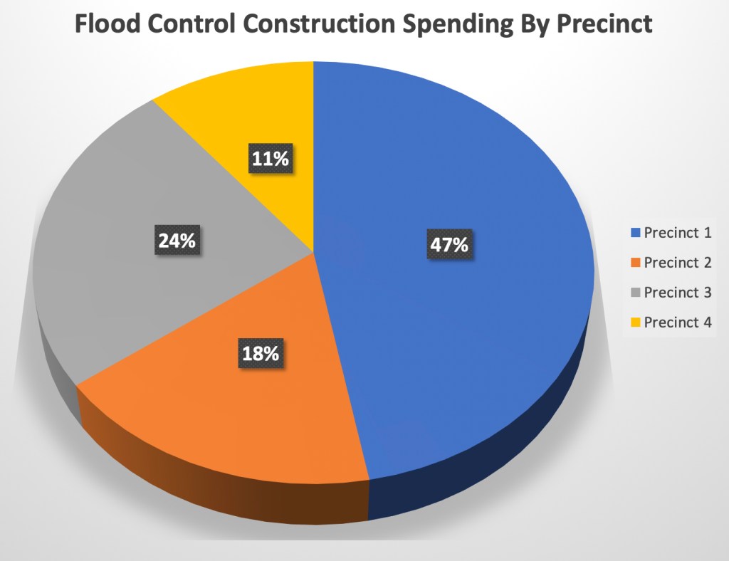
Precinct One receives almost half of all Flood Control District spending on construction, leaving the other three precincts to divvy up the other half.
Precinct 1 Gets More Than Its Fair Share of Federal Benefits
In part 2 of this series, we also learned that five of the six active federally-funded flood mitigation construction projects in Harris County are on bayous that flow through Precinct One. No other precinct comes close to receiving that kind of support. That means Precinct One receives more benefits from federally funded flood mitigation projects than any other Precinct in Harris County.
Based on total estimated contributions when completed. Data source: Harris County 2018 Federal Report.
If Commissioner Ellis or his surrogates have any data to back up their claims of discrimination in flood mitigation spending, they should share it. In every commissioners court meeting they spout the same half truths to bolster their share of flood mitigation dollars. So far, it appears to be working quite well for them. And not so well for residents in other precincts.
Posted by Bob Rehak on 6/26/2019
666 Days since Hurricane Harvey
https://i0.wp.com/reduceflooding.com/wp-content/uploads/2019/06/Buyouts.jpg?fit=1500%2C907&ssl=19071500adminadmin2019-06-26 17:22:492021-07-29 15:53:48Where Flood Mitigation Money Really Goes: Part Three
At Harris County Commissioners Court yesterday, “equity” proponents from low-to-moderate-income (LMI) neighborhoods in Precinct 1 again complained they weren’t getting their fair share of flood mitigation dollars. In crying “foul” over a perceived lack of buyout dollars, they ignore the fact that the bulk of Federal mitigation spending is on construction projects that benefit their precinct.
The Federal Government is contributing $814 million to joint HCFCD/Army Corps projects that benefit Precinct 1. Only one joint project in Harris County does NOT benefit Precinct 1.
Part One of this series focused on Harris County construction spending for flood mitigation. It found that Precinct 1, which is 78% African-American and Hispanic, received 47% of all Harris County Flood Control District (HCFCD) dollars spent on construction. That left three other precincts to divvy up the remaining half. But Federal contributions for construction spending are even more lopsided as the chart above shows.
2018 Federal and Harvey Reports Yield Surprises
In Part Two, I examine Federal construction spending in Harris County on joint Army Corps/HCFCD projects. Some are Corps-led; others County-led. Regardless, they all involve Federal contributions. Close review of the latest Federal Report from HCFCD and other information obtained through the Freedom of Information Act reveals some startling facts.
Precinct 1 benefitted from more Federally-backed projects than any other precinct.
Only one Federal project did not benefit Precinct 1.
Sims Bayou, which lies mostly within Precinct 1, was the only one of six Federal projects completed before Harvey. And it was one of the few bayous in the County that did not widely flood.
The Lake Houston Area received no Federal dollars for flood mitigation prior to 2018.
Federal Investments Ignored by Precinct 1 Activists
The only joint project actually completed before Hurricane Harvey was in Precinct One. It involved the widening of Sims Bayou and creating additional detention ponds. Together, these actions almost eliminated flooding during Harvey. A huge benefit to Precinct 1. See map below.
Sims Bayou in Precinct 1 was one of the few bayous in Harris County that did NOT come out of its banks during Harvey. See green arrow. The San Jacinto watershed (red arrow) flooded along its entire length and received NO Federal dollars prior to Harvey.
Sims Completed and Did Not Flood Widely
On page 6 of its Final Harvey Report, HCFCD states, “Sims Bayou was one of the few channels in the entire county that did not suffer widespread and extensive overbank channel flooding largely due to the completion of the federal flood risk reduction project and three HCFCD regional detention basins. Water levels for Harvey were generally below the historical records of Tropical Storm Allison and averaged between a 2.0% (50-yr) and 1.0% (100-yr) level downstream of Martin Luther King Blvd and generally below a 10% (10-yr) annual exceedance probability from Airport Road upstream to the headwaters.”
Sims Project Saved Thousands of Homes from Flooding
“Bottom line – the larger channel carried a lot more stormwater downstream away from subdivisions along the bayou and the large detention basins stored stormwater that would otherwise flow through subdivisions along the bayou.”
The Sims project received $390 million: $125 million from HCFCD and $265 million from the Army Corps.
In contrast, the Federal Briefing lists $0 in federal funding for the San Jacinto watershed.
Hunting Bayou and Achieving “Social Justice” in Precinct 1
At least one Army Corps project in Precinct One won Corps support becauseof the presence of LMI neighborhoods. Yet “equity” proponents contend the Federal government discriminates against them.
Page 79 of the Federal Report indicates Hunting Bayou (entirely within Precinct 1) received $98 million from the County and $68 million from the Corps, in part because of social justice factors. That’s another $165 million.
Residents claimed in their plea for funds that:
“Residents in the Hunting Bayou watershed deserve the same level of potential flood risk reduction as those who live in other parts of Harris County.“
“The economically disadvantaged Hunting Bayou residents struggle severely to recover from house and business flooding.”
“The Corps’ economic analysis is an important factor in prioritizing competing projects for annual Federal funding, but it is biased against economically disadvantaged communities like in Hunting Bayou.”
Prior to 2018, had Hunting Bayou residents received the same level of support as those in the more affluent Lake Houston Area, they would have received NO support from the Federal government.
Three Other Precinct 1 Watersheds Receive Major Federal Support, Too
Three other watersheds in Precinct 1 have received major federal and county commitments for construction of flood mitigation measures. Because they are in various stages of completion, I show total costestimates below to facilitate comparison.
Brays Bayou which flows through precincts 1, 2 and 3 will receive a total of $480 million; half from the county and half from the Corps. See page 60.
White Oak Bayou flows through Precincts 1 and 4. There, the County and Corps are excavating 9.7 million cubic yards of detention basins. That’s more than 5 times the volume of sediment removed from the San Jacinto to date. Estimate: $124 million, $90 million of it at Federal expense. See page 68.
Clear Creek flows through Precincts 1 and 2. Estimate: $249 million, $98 from local and $151 million from the Corps. See Page 91.
One Lone Exception
The Federal government partnered with HCFCD on only one project in Harris County that did not directly benefit Precinct One: a detention pond in Precinct 4 on Greens Bayou near 249, Beltway 8 and Cutten Road. This $58 million project received $43 million from the Corps. See Page 97.
The Corps does have other projects in Harris County, such as the Addicks and Barker reservoirs. However, HCFCD plays no active role in those. Likewise for the San Jacinto dredging project. This analysis looks only at joint projects that involve Harris County and the Corps.
Federal Construction Versus Buyout Dollars
Because Mr. Ellis’ surrogates base their arguments on buyouts, we need to put those in perspective.
Buyouts are tiny compared to construction spending. In Harris County, they represent just 6.6% of Federal construction spending for flood mitigation.
Page 120 of the 2018 Federal Brochure deals with buyouts. It shows approximately two dozen buyout projects completed in Precinct One. However, few if any appeared active at the time of publication in 2018.
In the entire county, FEMA was funding only $57.1 million in buyouts.
But the Army Corps contributes 19 times more than that in construction dollars for projects that benefit Precinct 1.
The numbers below represent Federal contributions only:
Sims – $265 million (In Precincts 1, 2)
Hunting – $68 million (In Precinct 1)
Brays – $240 million (In Precincts 1, 2, 3)
White Oak – $90 million (In Precincts 1, 4)
Clear Creek – $151 million (In Precincts 1, 2)
Total Estimated Federal Contribution to Joint Construction Projects that benefitted Precinct 1: $814 million
Total Estimated Federal Contribution to Joint Construction Projects NOT benefitting Precinct 1 (Greens): $43 million
Total Estimated Federal Contribution to Joint Projects in Lake Houston Area before 2018: $0
And Commissioner Ellis’ surrogates complain about discrimination! Maybe that’s why they get so much money.
Note that HCFCD does not break out spending “by precinct” for bayous that flow across precinct boundaries; they list only project totals. The list of bayous above represented ALL the HCFCD/Corps projects in the 2018 Federal Report.
Note also: Video of the commissioners meeting still had not been posted at the time I posted this story.
Posted by Bob Rehak on 6/26/2019
666 Days since Hurricane Harvey
https://i0.wp.com/reduceflooding.com/wp-content/uploads/2019/06/Federally-Funded.jpg?fit=1500%2C1103&ssl=111031500adminadmin2019-06-26 00:52:242021-07-29 15:55:28Where the Flood Mitigation Money Has Really Gone: Part Two
“Equity” proponents would have you believe that Harris County flood mitigation money is all going to high-income neighborhoods. However, data obtained from Harris County Flood Control under the Freedom of Information Act shows that construction spending for flood mitigation is highly concentrated in Precinct 1, which contains many low-to-moderate-income neighborhoods.
At the last Harris County Commissioner’s Court meeting, the issue of “equity” in the prioritization of bond funds came up again. Commissioner Rodney Ellis from Precinct 1 invited several groups to testify about how Low-to-Moderate Income (LMI) groups suffered at the expense of more affluent areas like Kingwood.
Alleged Bias Against LMI Groups Distorts True Picture
They alleged bias against LMI groups by focusing on only one aspect of flood mitigation: buyouts. They said that high-income areas received preference over low-income areas when buying out flooded homes. That’s because of higher home values and thus higher repetitive losses. However, by focusing on this one issue, and ignoring the big picture of Flood Control construction spending, these groups distort the true picture of where flood mitigation dollars actually go.
In the last 21 years, Precinct 1 has received at least four to five times more construction dollars from Harris County Flood Control than Precinct 4 which contains Kingwood.
In fact, Precinct One received the single largest construction project in the history of Harris County Flood Control. The excavation of the Kuykendahl and Glen Forest Stormwater Detention Basins cost $59,840,117.41. In contrast, during the last 21-years, the entire San Jacinto River Watershed (the largest in the county) received only $3,345,976.28 in construction funds – one-eighteenth of what that Precinct 1 detention basin project cost!
The money spent on the San Jacinto also represented just one half of one percent of the $663,894,766.38 spent on all construction by the Flood Control District during that 21-year period.
In contrast, the Brays and Sims Bayous, both of which run through Commissioner Ellis’ district, received almost 100 times that amount. The $330 million spent on those two watersheds alone represented virtually HALF of the entire $663.9 million Flood Control District construction expenses in the last 21 years!
Lopsided Distribution of Flood Mitigation Money
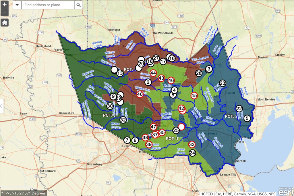
In fairness, note that those watersheds do not lie entirely within Precinct 1. However, Precinct 1 also contains parts of Greens Bayou, White Oak Bayou, Halls Bayou, Hunting Bayou, Buffalo Bayou and Clear Creek (see map above). If you add in even a small portion of $229.4 million spent on those watersheds, the Precinct 1 construction numbers become even more lopsided.
Greens received $74.3 million
White Oak received $47.8 million
Halls received $22.3 million
Hunting received $23.7 million
Buffalo received $44.3 million
Clear Creek received $17 million.
Meanwhile, Kingwood received $0 construction dollars but suffered more than a billion dollars worth of damage during Harvey. Yet Mr. Ellis and his friends imply we hog flood mitigation dollars from poor people. THEY demand EQUITY! It’s time someone called this what it is – BS.
Actual Construction Spending by Precinct since 1998
Between 1998 and 2019, Precinct 1 received 47% of all Flood Control District construction funds spent on projects entirely within each precinct. These percentages do NOT include spending on projects that cross districts.
Precinct 1
$275,835,964
Precinct 2
$103,529,679
Precinct 3
$143,873,825
Precinct 4
$62,427,867
Precinct Discrimination Disguised as “Equity”?
Precincts are supposed to be roughly equal in population. Yet these figures are so lopsided, one could argue that Mr. Ellis and his friends are deliberately crying discrimination to get a larger share of the pie at the expense of areas like Kingwood. But it’s more complicated than that; Precinct 1 is also taking money from LMI neighborhoods in other precincts.
Look at the distribution of LMI neighborhoods throughout Harris County in the map below. It’s based on five years of recent HUD data. You can see a broad, concentrated LMI band across northern and eastern Harris County.
If anything, these numbers demonstrate a consistent pattern of geographic discrimination against residents of other precincts. Rodney Ellis’ Precinct 1 received 47% of construction dollars for flood control, leaving the other three precincts to divvy up the other half. Precinct 4 contains roughly one fourth of the population but received just 11% of construction dollars.
I’m not suggesting that the Precinct 1 projects were not needed or that the money was not spent wisely. I am suggesting that Precinct 1 LMI residents should not paint Kingwood as a villain. To do so is intellectually dishonest. We are not taking construction dollars from LMI neighborhoods. The County’s own data shows the opposite.
Precinct 1 is taking dollars from affluent and LMI neighborhoods alike.
I will cover other aspects of this story in upcoming posts. In the meantime, County Commissioners vote today on approving the vendor for the Kingwood Area Drainage Assessment. See item 2-B-5 on page 9. The approval of the study caused the equity flap at the last meeting. Let’s hope it doesn’t cause another one in this meeting. After all, the Flood Bond was sold to citizens as a tool to correct problems based on need, not income.
Posted by Bob Rehak on 6/25/2019
665 Days since Hurricane Harvey
https://i0.wp.com/reduceflooding.com/wp-content/uploads/2019/06/Active-Construction-Projects.jpg?fit=1500%2C999&ssl=19991500adminadmin2019-06-25 00:53:512021-07-29 16:18:03Where Flood Mitigation Money Has Really Gone: Part One
A close reading of the Woodridge Village Section One plat shows that the Montgomery County engineer disclaimed any responsibility for the impact of Woodridge Village both upstream and downstream, in fact, anywhere in the watershed. At the same time, the county engineer certified that the plans developed by LJA Engineering met all the requirements of Montgomery County Commissioners. See below.
Enlargement from first page of plat for Woodridge Village.
Gaps in Regulations
On May 7th, at least 196 homes flooded downstream of Woodridge Village. Many other homes in Porter also flooded on the upstream side of the subdivision.
This raises the question of whether Montgomery County floodplain regulations are sufficient to protect neighboring residents.
To complicate matters, the flooding happened before construction of several detention ponds – despite the fact that the land near the area that flooded had been clearcut for more than six months. However…
According to Montgomery County’s Floodplain Administrator, County regulations look only at pre- and post-construction runoff rates. They do not address anything that happens during construction.
Montgomery County has no regulations that dictate the sequence of construction. For instance, could building detention ponds on one section of land before clearcutting another have reduced flood risk and averted disaster?
Need for More Consistency to Protect Neighbors
I have previously posted about the differences in floodplain building regulations in various jurisdictions. These differences cause confusion for residents and property owners. They may feel protected when builders ten feet away on the other side of a county or city line play by an entirely different set of rules.
These gaps in regulation provide a good example of why the State of Texas should step in and bring some uniformity to guidelines. We need sensible regulations that enable growth without endangering downstream residents.
The thoughts in this post represent my opinions on matters of public policy and safety. They are protected by the First Amendment of the U.S. Constitution and the Anti-SLAPP statute of the great State of Texas.
Posted by Bob Rehak on 6/24/2019
664 Days since Hurricane Harvey
https://i0.wp.com/reduceflooding.com/wp-content/uploads/2019/06/Screen-Shot-2019-06-23-at-5.59.29-PM-e1561331450467.png?fit=1500%2C445&ssl=14451500adminadmin2019-06-23 19:39:052019-06-23 20:01:43Fine Print: Montgomery County Engineer Disclaimed Responsibility for Impact of Woodridge on Upstream and Downstream Drainage
Since Harvey, the Lake Houston Area has seen some huge changes for the better in the San Jacinto River Authority (SJRA). When the Governor visited Kingwood and took a helicopter tour of the San Jacinto River basin after Harvey, he directed the SJRA to establish a flood mitigation division. He also appointed two directors from the Lake Houston area to ensure downstream representation on the SJRA board.
Many Improvements Since March 2018
Since then, Kaaren Cambio and Mark Micheletti, the two new directors from the Lake Houston area, have led the charge to lower Lake Conroe seasonally. This ensures a greater buffer against floods.
The effort paid off this year when heavy back-to-back-to-back rains in early May would have forced a large release from Lake Conroe had it not already been lowered. That release, added to already swollen tributaries, would almost certainly have threatened low lying homes and businesses.
The SJRA will again lower Lake Conroe during the peak of Hurricane season. Starting August 1, it will take Lake Conroe down one foot. Beginning August 15, they will take it down another foot until October 1.
The SJRA is also working with Harris County Flood Control to install more upstream gages and turn the Harris County Flood Warning System into a Regional Flood Warning System with customizable alerts. The goals: create more awareness of upstream dangers to give people more time to evacuate and save valuables in the event of a flood. Said another way, avoid middle-of-the-night surprises like we had during Harvey.
Finally, the SJRA is leading a joint river basin study that hopefully will lay the groundwork for additional upstream detention, more flood gates for Lake Houston, and an ongoing maintenance dredging program. So, many good things are happening.
Cambio’s Term Expiring
However, Cambio’s term on the board expires this year. She wants to stay in the position and I hope she does. Cambio has worked tirelessly to mitigate flooding on so many levels. Her position as a key staffer for Congressman Dan Crenshaw also makes her uniquely qualified to help coordinate efforts from Federal, State and local agencies. She deserves reappointment.
The answer is, “In the short term, no.” Cambio’s seat on the board is the only one up for renewal this year.
SJRA Sunset Review Coming Up
However, in two years, the entire SJRA will come under close scrutiny as part of a sunset review. A sunset review is an evaluation of the need for the continued existence of a program or an agency. It assesses their effectiveness and performance, and recommends either retaining, modifying, or terminating them.
No one expects the SJRA to be terminated. But many other river authorities that have gone through the sunset review process, have had a complete overhaul, said one source who spoke on condition of anonymity.
The Sunset Commission has been brutal at times. For instance, between 2016 and 2017, the Commission reviewed four river authorities and noted:
“Sulpher River Basin Authority Board has not built the trust needed to effectively carry out its mission.”
“Central Colorado River Authority no longer serves a necessary public purpose.”
“Upper Colorado River Authority has not set priorities to ensure its operations meet changing local watershed needs.”
“Palo Duro River Authority of Texas lacks flexibility to adapt to changed local circumstances.”
Their report makes fascinating reading. One thing that became clear in scanning it is that, like most good performance reviews, the Commission judges performance against objectives. In the case of these Authorities, enabling legislation spells out the objectives.
Enabling Legislation Established SJRA Goals
That prompted me to review the enabling legislation for the SJRA. The sections discussing goals begin on page 2 of this PDF. I have summarized them below.
The state created the SJRA (originally called the San Jacinto River Conservation and Reclamation District) to “conserve, control, and utilize to beneficial service the storm and flood waters of the rivers and streams of the State.” Section 2 of the enabling legislation mentions floodwaters three times.
Prevent the devastation of land from recurrent overflows.
Protect life and property.
Regulate the waters of the San Jacinto River and its tributaries.
Build dams and distribution networks that provide waters for cities, towns, irrigation, agriculture, commercial, industrial, mining and other beneficial uses.
Develop drainage systems that enable profitable agricultural production.
Conserve “soils against destructive erosion and thereby preventing the increased flood menace incident thereto.”
Forest and reforest the watershed to aid in the prevention of soil erosion and floods.
Encourage, aid, and protect navigation and harbor improvements.
Acquire land for parks and recreation, and to build park and recreational facilities thereon.
Dispose of sewage and industrial waste.
Construct, improve, maintain, operate and repair water and sewage plants and distribution networks.
How Would You Rate Performance against These Goals?
It seems to me that the SJRA does a great job at its basic mission. And they’re improving at flood mitigation. However, for decades, the SJRA ignored other crucial parts of its job description, including flood and erosion prevention; reforestation; parks and recreation; and navigation protection. In fairness, the Legislature never funded those mandates. The SJRA’s only income comes from the sale of water which it impounds.
Still, you would think somebody could pick up a phone and call the TCEQ for help with some of these things. For instance, sand mines along the banks of the river dump effluent and sediment directly into the drinking water supply for millions of people. It will be interesting to see what kind of changes the Texas Sunset Commission recommends when the SJRA comes up for review.
For an interesting history of the SJRA, see Chapter 4 of this doctoral dissertation by Andrew C. Baker at Rice University. It paints a fascinating picture of the problems the SJRA had in originally fulfilling its basic mission and how the SJRA overcame them with help from the City of Houston.
Note: For future reference, the SJRA enabling legislation has been added to the Reports page under the SJRA tab.
Posted by Bob Rehak on 6/23/2019
663 Days after Hurricane Harvey
https://i0.wp.com/reduceflooding.com/wp-content/uploads/2018/05/Untitled-1.jpg?fit=260%2C279&ssl=1279260adminadmin2019-06-23 00:22:542024-05-09 20:16:47SJRA Update, Upcoming Sunset Review and Enabling Legislation
In 1969, the rock group Three Dog Night released a hit recording called “One is the Loneliest Number.” As I listened to Elaine Phillips tell me her story about the May 7th flood, I couldn’t get the song out of my head. Elaine, still fighting off the effects of chemo, found herself alone at home with floodwaters rising around her for the fifth time since 1997. With her husband in New York on business, and her grown children in Austin and Houston’s Midtown area, this CPA is now trying to fight cancer, contractors, and “government logic” – by herself. As this Kings Forest resident reaches for the Xanax, she’s still reaching out to help other “flood virgins,” as she calls them. Below are portions of my interview with a woman “at the end of her tether.”
Rehak: You bought this home in…
Phillips: July of 1997.
Rehak: And you’ve flooded how many times since?
Flooded Five Times in 22 years
Phillips: This is my fifth, I think. And it had flooded two times before we moved in.
Rehak: I took a picture of you earlier pointing to the water level from Harvey on your house. It looked like at least six feet.
Elaine Phillips showing how high the water reached in her home during Harvey.
Phillips: Yeah.
Rehak: You were reaching well above your head. Did it get that high previously?
Phillips: Just enough to require three feet of your wall to be ripped down.
Water height on May 7Erosion from/through the Phillips’ yard has likely caused sediment to alter the gradient in her drainage ditch.
Rehak: Earlier today, you and I walked around your property. You showed me a berm that your landscaper built to help divert water from your house to the drainage ditch. Erosion from that water was starting to crack your driveway and expose a drain pipe from your pool. So you’ve lost soil back there. And the water isn’t draining fully to the corner where it should. The city inspector who came out and talked to you about it said it was…?
Phillips: “Performing as designed. No action needed.”
Water sometimes flows backward from the drain toward the Phillips house.
Rehak: Your response to that was?
Phillips: It was designed to flood my home? Then success! (She throws up her hands and laughs.)
Rehak: Do you think that eroded sediment may have altered the gradient in the ditch and be backing water up?
Phillips: Absolutely. Sometimes it flows backward in the ditch…away from the drain. I’ve lived here since ‘97 and we’ve never had the ditches worked on. Logic tells you that the sediment that gets left behind on all of these heavy rains is going to change the landscape and create more problems.
Just Finished Harvey Repairs and Then…
Rehak: What happened on May 7th?
Phillips: The first thing we always notice is the backyard filling up.
Rehak: And then?
Phillips: Within a heartbeat, it’s over the pool. And once it’s over the pool, it’s up to the back door.
On May 7, water started seeping through the back of the house from the pool area.
Rehak: And?
Phillips: Then I noticed it coming in. I ran to the front door and then it starts coming in there, too. But it starts at the back first. Then I watch the pool and once the pool has overflowed I know it’s a matter of minutes.
Rehak: You said on May 7th that the first water came from the back.
Phillips: The laundry room right there is where I noticed it first. I always start by putting a bunch of towels in front. Isn’t that adorable? Thinking that it’s just a little bit. And so I had towels in all the doors. I even sandbagged for Harvey. That was adorable, too.
Rehak: On May 7th, how long after the start of the rain did it take for the water to get in your house?
Phillips: It started around 10:30 a.m. and was in by 12:44 p.m. That’s when I shot this photo. There were never any breaks in it for the drains to catch up.
Video showing intensity of rain on May 7, 2019.
Home Alone
Rehak: Your husband was working in New York?
Phillips: In the Empire State Building. I texted him that we were flooding and asked whether he was going to come home? He said, “Only if you need me.”
Rehak: He wins the sensitivity award.
Phillips: I’m glad you see the humor in that. I did what I could. I had already started taking some stuff upstairs. Then the next morning I just got in my car with my dogs and drove to Austin, where I stayed for five days.
Refurbishing the kitchen that had just been refurbished from Harvey.
Begging for a Buyout
Rehak: Would you accept a buyout?
Phillips: We’ve begged for one. FEMA has paid us around a million dollars over these five floods. It just makes common sense. As a CPA, I ask, “When do you cut your losses?” You buy this home and quit paying these people two to three hundred thousand every time they flood. But unfortunately FEMA’s not really here. We need to appeal to Harris County. I did speak to the county guy and he said they don’t buy out homes that aren’t adjacent to Flood Control property. So they continue to pay out. Hundreds of thousands each time it floods.
Rehak: You paid how much for your house?
Phillips: $180,000 back in 1997.
Feeling a bit overwhelmed.Luckily, the home has an upstairs.
Repetitive Losses Add Up to 4-5X Value of House
Rehak: So they’ve already paid out the value of the house about five times!
Phillips: I don’t know what one hundred and eighty thousand dollars in 1997 would equal in 2019. But yes, they’ve paid four to five times – at least. Thankfully, we’ve always had flood insurance from the day we bought it. I don’t think it was in a flood zone back then, but I think it’s deemed a 100-year flood zone now. We barely got done with the repairs from Harvey when May 7th hit. Our appliances were less than a year old!
The Phillips’ garage has become a carpentry shop.
One Problem on Top of Another
Rehak: You’re in chemo. Life’s been ganging up on you lately.
Phillips: I was diagnosed with cancer last November. It was a reoccurrence. I had cancer in 2009. I was in chemo from December to April and then two weeks after my last chemo, we flooded. And now I get to do this (gesturing to the construction work all around us). And I will say if there’s anything positive that came from it is that it has forced me to get up and start moving. I couldn’t just lay around convalescing.
Rehak: Your kids are grown and gone. Your son is in…
Phillips: Austin.
Rehak: Your daughter is in…
Phillips: Austin and the youngest son is down in Midtown in Houston.
Rehak: And your husband is working in New York. You’re in a floating home. On chemo. Can it possibly get any worse?
Phillips: You know what? The sad thing is I know it can. And so I always feel blessed as long as my children are safe and healthy. The fact is this house is paid for. Yes, I can continue to live in it. I’ll just live upstairs and come down to cook or whatever.
Ideally, I would like to sell it. Or be bought out and then move to a house on a hill. A small house on a hill.
Lox and louvers for breakfast, anyone?
Feelings Toward Governmental Entities
Rehak: How has the government handled your case? You’ve dealt with them on the buyout issue…the drainage issue. What are you feeling at this point?
Phillips: Believe or not, I actually have nothing but positive feelings about FEMA other than the fact that they need an accountant that says, “Hey let’s quit paying this Phillips family. Let’s just buy their house.” Other than that, they pay quickly. Which makes it easy to get a contractor because if they know you have FEMA, they know they will get paid. In that respect, I have no problems with FEMA.
The City? I’ve talked to well-meaning people; the man that came today couldn’t have been more polite. But nothing gets done. And there’s no rhyme or reason to what they do. They’re grading ditches two streets over. but not here.
Rehak: So they’re grading ditches where people didn’t flood and not grading them where people did flood?
Phillips: Yes. They said, “Your area is at a lower elevation.” So basically, they’re saying, “You can’t be helped.” But I said, “So the people that need it most don’t get help?” The idiocy of it all! (She practically growls at this point.)
Getting to a Happy Place
Rehak: What would you like to see happen now?
Phillips: In the short term as in now, tomorrow, next week? I would love the ditches to be regraded. From my house to the corner at the proper slope.
Rehak: That would cost less than fixing up the house again. (Then…noticing that she seems almost happy.) You don’t seem very stressed, despite all of this.
Phillips: I’ve been stressed since this entire thing started. The City, the County, the contractor, the workers, the adjuster…who has been a complete jerk this time…they all pushed me to the edge. And then health issues, I’ve been so stressed out.
But then yesterday, something came over me. I just thought “I don’t even care anymore” and it was such a freeing feeling. When I was diagnosed six months ago, my doctor prescribed me some some Xanax (an anti-anxiety medication). I’m not sure where the Xanax is now, but I think I need to find it and just go to my happy place. (She laughs.)
I will just walk my dogs. WHISTLING a tune and I do not even care. I will say this. Purging your home was an oddly good feeling to it. Nothing purges your home like a flood.
Putting Albums 4′ Up and Getting 6′ of Water
The worst part was, stupidly, things that belonged to my mom who is no longer with me. I lost all of that. It was on the first floor. My photo albums of my children. I put them on shelves four feet high. Then we got six feet of water. So, I’ve lost all of the things that can’t be replaced. That breaks my heart. I still kept those photo albums, but they’ve swollen like this big (she spreads her arms wide). And every time I open them I just want to cry, so I just don’t anymore. But as far as things, you know…clothes, shoes…I lost everything I owned. I don’t care.
Rehak: Where do you go from here?
Phillips: Ideally…SELL IT. My husband has wanted to downsize forever. I just need to have a bit of a yard for the dogs…and on a hill. I don’t need a six bedroom, four-and-a-half bath house. I don’t regret living here one bit because my kids growing up here had an awesome time. I couldn’t have wished for a better neighborhood.
Rehak: What else would you like to tell people?
Looking for Results
Phillips: Everybody I talk to has been great. But I just haven’t seen any results. Even getting the debris picked up took a long time. It took four work requests. You put in a work request on 3-1-1. And then they say, “OK we’ll be out on such and such a day.” But then they didn’t come.
When I called to see what happened, they said, “Well, that work order is closed. It’s complete.” I say. “No, it’s not. The trash is still there.” So they rescheduled it and told me, “They’re coming tomorrow.” And guess what. They didn’t come again. It took four requests before they finally came!
I think what put me over the edge before I arrived at my Xanax Happy Place was knowing that they graded the ditches over on Valley Manor. And that’s all I wanted here all along.
Rehak: I feel for you.
Flood Virgins
Phillips: I’d already been through chemo twice. It was hell. But never in my wildest dreams did I think a day of heavy rain would flood me.
The people in Elm Grove. It broke my heart watching them being interviewed on TV, because I believe the majority of them did not have flood insurance. They had no reason to think they needed it when they were interviewing them on TV. They were just crying and sobbing. Grown men were crying! And it really broke my heart even though I was in the same boat, but I jokingly referred to them as “flood virgins” because they had no idea what it’s like. The heartbreak and the lack of control. There’s nothing you can do.
Tips for Dealing with Contractors
A lot of them had questions. Who do I call? What do I do? Can anyone recommend a contractor? They didn’t know where to go. I know it so well I don’t even need a contractor anymore. Maybe I should become their contractor.
Despite digging in her heels from time to time, Elaine Phillips contractor has returned for the last three floods. She must be doing something right.
Rehak: Any tips for dealing with contractors?
Phillips: Except for $10,000 to $15,000 to get them started upfront, pay after the work is done. Only dole out money for work that’s completed. And don’t feel like you’re being bitchy if you say, “Well, I’ve already given you five thousand or ten thousand and you’ve only done this.” No. You dig in your heels. The contractor and I have a love/hate relationship. He loves it because we pay him. We pay him on time. And we pay him the full amount. But he also knows he has to work hard.
Posted by Bob Rehak on 6/21/2019
661 Days since Hurricane Harvey
https://i0.wp.com/reduceflooding.com/wp-content/uploads/2019/06/PhillipsElaine_01_01.jpg?fit=1000%2C1500&ssl=115001000adminadmin2019-06-21 17:55:082019-06-21 19:21:23Elaine Phillips’ May 7th Flood Story: One is the Loneliest Number
HB 1820 gives the Liberty County Drainage District authority to: issue bonds; impose assessments, fees, or taxes; and exercise limited powers of eminent domain.
The Senate Research Center’s analysis of the bill noted the high amount of damage in Harris County due to Hurricane Harvey. Stakeholders from the Liberty county hoped to avoid that kind of damage by creating the Drainage District. The Senate Research Center found that, “Areas within Liberty County are prone to flooding, especially where there are low-lying areas, undersized culverts and bridges, and railroads, just to name a few. The creation of a drainage district would provide an additional funding mechanism, through grants or ad valorem taxes, for improvements.”
Local Bill Passed Almost Unanimously
The bill, which applies only to Liberty County, passed both houses with one dissenting vote in the Senate and only four in the House.
Map of Liberty, County Texas.
The bill creates a temporary board of directors which must hold a confirmation election with the public before September of 2022.
Liberty County is mostly rural and agricultural. In the 2010 census, it had a population of just 75,563.
Liberty County borders Harris County on the east. It extends from Cleveland to below Crosby. It includes Dayton and the town of Liberty on FM1960. The Trinity river runs through Liberty County as well as the Luce Bayou Inter-basin Transfer Project. That project pumps water from Lake Livingston and the Trinity River to Lake Houston to help ensure our future water supply.
The Texas Water Development Board lists the Trinity River as the longest in the state with a watershed entirely within Texas. Twenty-two tributaries drain into the 710 mile long river which has a watershed of approximately 18,000 square miles.
It will be important for Liberty and Harris County Flood Control/Drainage Districts to work together to help mitigate flooding in areas such as Huffman near the county line.
Posted by Bob Rehak on 6/20/2019
660 Days after Hurricane Harvey
https://i0.wp.com/reduceflooding.com/wp-content/uploads/2019/06/Liberty-County.jpg?fit=1500%2C1170&ssl=111701500adminadmin2019-06-20 18:29:522019-06-21 07:16:57Legislature Creates Liberty County Drainage District, Subject to Confirmation Election
Yesterday, I posted about the discovery of something called the Odom Lake Swamp on a 70-year-old map. Many of the homes that flooded in Elm Grove on May 7 were built in or near it. But learning that required scaling and aligning maps in Photoshop. It’s a time consuming process and not everyone has Photoshop. If you’re considering buying a piece of property, luckily, there’s an easier way to check on its past: the history function in Google Earth Pro.
History Function In Google Earth Pro
Google Earth Pro contains dozens of aerial and satellite images that are already scaled and aligned. The program is a free download and makes scrolling back through time simple. When you first open the program, you’ll see a map of the world. Click on the area that interests you to zoom closer in steps.
Then:
From the menu at the top of the screen, select “View/Historical Imagery”
Click on the Clock icon in the menu bar.
Arrows and a timeline will appear at the top left of the screen.
Scroll back and forth through time by clicking on the arrows.
To show streets that exist today (but that didn’t exist when the image was taken), select View/Sidebar. Then check Labels/Borders and Roads.
Here’s what you see when you scroll back to 1978 (minus the red circle which I added to highlight the area of interest).
Odom Lake Swamp in 1978.
Looking at this, you wouldn’t have known that the large flat, featureless area was called Odom Lake Swamp. But you could tell that something unusual was going on there. And that might tell you to dig further into the area’s history.
“Reading” Satellite and Aerial Images
Google Earth Pro doesn’t show contour intervals as a topographic map would. Nevertheless, it can still tell you a lot. Flat featureless areas like this in the middle of dense forests can indicate ponding, at least on a seasonal basis. Translation: Low area.
Note several other discontinuities in the image above:
A small pond in the lower left (north of Sherwood Trails)
A depression near the upper left that interrupts the straight white line
A triangular area in the upper right where no trees are growing.
In the image below, I zoomed in closer on the Odom Lake Swamp. The image shows what at the time was a dry lake bed. Taylor Gulley had just reached the area and had most likely drained what was a seasonal pond or swampy area. Taylor Gulley itself (bottom right) had not yet been excavated to the county line (thin green diagonal line in upper left).
Close up of Odom Lake Swamp. Taylor Gulley at the bottom was still under development at the time of this image in 1978. Streets had not yet been built in this area. The white lines show where streets are today.
Nature Never Forgets
As one expert told me: “Where old channels, swamps, meanders, etc. were filled in, during major floods, water always seeks the lowest point. Even if you fill in an area, it usually is still the lowest point of a larger area (or watershed) and during large rain storms, the water finds its way there.”
It only takes a one degree slope to make water move across concrete (two degrees through grass or foliage). That’s barely visible. It underscores the need to consult maps and tools like Google Earth when buying property.
Awareness of potential problems is your best way to prepare for or avoid them.
https://i0.wp.com/reduceflooding.com/wp-content/uploads/2019/06/Odum1978.jpg?fit=1500%2C1062&ssl=110621500adminadmin2019-06-20 14:20:082019-06-20 14:21:10Google Earth Pro: Another, Easy Way to Check on a Property’s Hydrologic History