Reasons: unusually warm seawater in the Atlantic and the likely LACK of an El Niño in the Pacific. El Niño in the Pacific usually sets up wind shear that tears apart storms in the Atlantic. Said another way, they help keep tropical storms from developing into full-force hurricanes. But without El Niño, the lack of shear allows more storms to develop and creates active hurricane seasons.
Source: NOAA, From April 2, 2020. Shows most of Atlantic has above-normal sea-surface temps, and that temps immediately offshore the upper Texas and Louisiana Coasts are now 4-5 degrees above normal.
CSU predicts 18 named storms will develop.
AccuWeather released its hurricane season predictions a week earlier. They predict 14-18 names storms. Of those, seven to nine will likely become hurricanes, and two to four are likely to hit the U.S. mainland.
NOAA should issue its forecast in late May.
Hurricane season extends from June 1 to November 30.
March Warmth Unrelated to Hurricane Season
Jeff Lindner, Harris County Flood Control’s meteorologist, says that the unusually warm March that south Texas just experienced (about 8 degrees above normal) will have little effect on tropical storm formation. “There is some correlation with a warm Gulf of Mexico and severe weather and flooding along the Gulf Coast during the spring months. But there is little to no correlation to tropical activity in the Gulf during summer months.”
3-4 Inches of Rain Possible in Next 5 Days
Speaking of Spring rains, Lindner also predicts a stormy weather pattern will set up over our area for the next 5-7 days. He says “some severe weather and heavy rainfall will be possible.”
“Widespread rainfall amounts of 1-2 inches with isolated totals of 3-4 inches will be possible between this afternoon and Saturday,” says Lindner. He predicts the heaviest rainfall across area north of I-10. Storms could train, producing the higher rainfall amounts. But Lindner also adds, “It has been dry of late and the soil can take several inches of rainfall as long as it is not all at once.” So no one is talking about flooding at this point.
NOAA predicts a slight chance of severe storms Friday evening, mostly west of Houston.
Here’s where NOAA predicts the heaviest rains to fall during the next 5 days and what the total accumulations should be.
Posted by Bob Rehak on 4/2/2020
947 Days since Hurricane Harvey
https://i0.wp.com/reduceflooding.com/wp-content/uploads/2020/04/atl_anom.gif?fit=800%2C737&ssl=1737800adminadmin2020-04-02 12:59:582020-04-02 13:06:34“Above-Average” Hurricane Season Predicted This Year
Harris County Precinct 4 Commissioner Jack Cagle has placed an item on next Tuesday’s Commissioners’ Court Meeting that will affect the future of Kingwood. It’s to discuss the possibility of Harris County Flood Control spending $10 million to buy the Perry Home’s Woodridge Village property. It contributed to flooding hundreds of homes in Elm Grove and North Kingwood Forest TWICE last year.
Where Will Two More Votes Come From?
Cagle needs at least two more votes on Commissioners Court in addition to his own to approve the effort. Reportedly, Judge Lina Hidalgo, Commissioner Adrian Garcia in Precinct 2 and Commissioner Steve Radack in Precinct 3 are the most “gettable.”
Here’s how you can help. Email or call these officials today. Urge them to support Cagle’s motion. Do it NOW. I’ve listed their contact info below.
At Stake: The Future of Kingwood
Ten flooded homes in a row, all vacated. Photo taken in North Kingwood Forest in December 2019. All homes back up to Woodridge Village.
Without help, Elm Grove and North Kingwood Forest could drag down the reputation of the entire Kingwood community.
Additional flooding could devastate remaining homeowners. Many were already struggling to pay repair bills from two floods. Now corona-virus layoffs make that even more difficult.
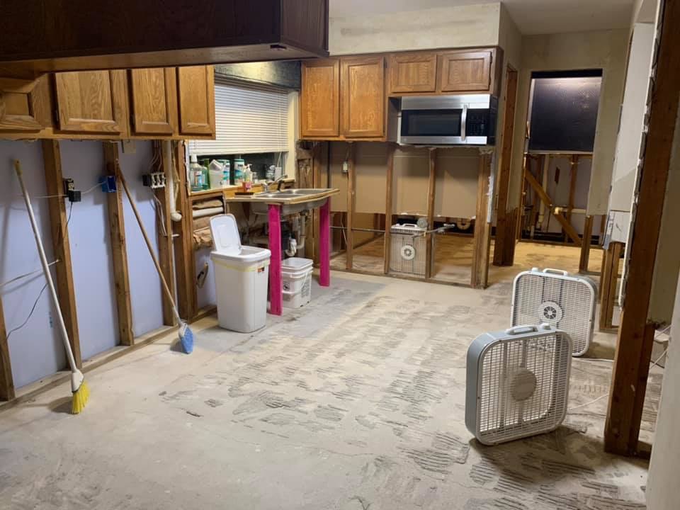
Elm Grove kitchen home five months after being flooded a second time.
These are working class neighborhoods. As much so as any in Harris County. People simply can’t afford to flood again.
Language in last year’s flood bond allows Harris County Flood Control District to buy property in neighboring counties for the purpose of building upstream detention. The lack of detention on Perry Homes’ property is the primary reason hundreds of homes in Kingwood flooded. Two years after clearing the property, Perry Homes still has constructed only 23% of the needed detention.
No Other Good Alternatives At This Time
Harris County Flood Control reportedly can start work on expanding detention capacity as soon as Commissioners reach a deal.
If they can’t, Perry has said it will sell Woodridge Village to another developer or continue to develop the property itself. However, if that happens, the detention ponds on the property would still likely be undersized by 40%. That’s because Perry Homes rushed to get their plans approved before the new, higher Atlas-14 rainfall standards went into effect.
Help Now! Here’s How
To contact Judge Hidalgo, Commissioner Garcia or Commissioner Radack:
Remind them that Harris County receives drainage from at least FIVE surrounding counties. This problem is a county-wide problem, not just a Precinct 4 problem.
Please call or write now if you live in the Kingwood, Huffman, Humble or Atascocita areas. Even if you did not flood, flooding from Woodridge Village affects you and your home value. No one in this area can afford to let this sore fester any longer.
Posted by Bob Rehak on 4/1/2020
946 Days after Hurricane Harveyand 195 since Imelda
https://i0.wp.com/reduceflooding.com/wp-content/uploads/2019/09/Elm-Grove-9.19_68.jpg?fit=1500%2C1000&ssl=110001500adminadmin2020-04-01 16:09:432020-04-01 18:46:07What You Can Do Right Now to Encourage HCFCD to Buy Woodridge Village Property
The EPA has suspended normal enforcement of air and water pollution rules during the corona virus epidemic. Critics fear it could cause more deaths. They also fear that rules forced through during the emergency could hamper future pollution control efforts. Specifically, a new, broadened rule would limit use of research based on confidential health information in regulatory decisions.
Full Text of EPA Memo
This 7-page memo from the EPA outlines the new policy. It says, the EPA will “generally not seek stipulated or other penalties for noncompliance…” The thrust of the memo: EPA is counting on industry to self-report violations. If violations relate to worker shortages due to the virus, EPA will not seek penalties. EPA will also give offenders time to remedy the situation.
Reaction from Interceptor
Sharon Lerner writes in The Interceptor that “EPA IS JAMMING THROUGH ROLLBACKS THAT COULD INCREASE CORONAVIRUS DEATHS.” The article cites the case of a Pasadena refinery exceeding benzene emission limits. It also cites problems in St. Johns, Louisiana. St. John reportedly has the highest cancer risk from air pollutants in the country. Area residents are routinely exposed to dozens of air pollutants, including the carcinogen chloroprene.
Residents worry that their weakened immune response from the chemicals will make them even more susceptible to the virus.
Review by New York Times
Lisa Friedman writes in The New York Times that “E.P.A., Citing Coronavirus, Drastically Relaxes Rules for Polluters.” The EPA, says the article, will focus during the outbreak “on situations that may create an acute risk or imminent threat to public health or the environment” and said it would exercise “discretion” in enforcing other environmental rules. In other words, they will focus primarily on the worst cases.
Ms. Friedman interviewed former EPA administrators. Gina McCarthy, who led the E.P.A. under the Obama administration and now serves as president of the Natural Resources Defense Council, called it “an open license to pollute.” Cynthia Giles, who headed the E.P.A. enforcement division during the Obama administration, said: “This is essentially a nationwide waiver of environmental rules. It is so far beyond any reasonable response. I am just stunned.”
A current spokesperson for the EPA, Andrea Woods, disagreed. “For situations outside of routine monitoring and reporting,” she said, “the agency has reserved its authorities and will take the pandemic into account on a case-by-case basis.”
Protest by 21 Environmental and Watchdog Groups
Meanwhile, Rebecca Beitsch reports in The Hill that “Coalition petitions EPA for disclosure as agency OKs suspension of environmental monitoring.” She says, “Environmental groups have characterized the memo as a license to pollute, as companies will not have to submit regular reports to the EPA showing they are not violating environmental laws.” She cites a petition spearheaded by the Natural Resources Defense Council which was signed by 21 environmental and watchdog groups. “We fully appreciate the disruption and harm caused by the COVID‐19 pandemic. But EPA’s unprecedented non‐enforcement policy creates a clear opportunity for abuse,” states the petition.
LA Times Reports on Reaction by California Officials
The Los Angeles Times reports in an article by Susanne Rust, Louis Sahagun and Rosanna Xia. “Citing coronavirus, EPA suspends enforcement of environmental laws.” The LA Times article focuses on the response of California officials. “The severity of the COVID-19 crisis should not be used as an excuse by the EPA to relax enforcement of federal environmental laws designed to protect public health and safety,” said Serge Dedina, mayor of Imperial Beach. His city, on the Mexican border, is under constant siege from pollution. “This crisis has only underscored why protecting public health and safety and our environment is more critical than ever.”
Is EPA Using Crisis as Cover to Make Concessions to Polluters?
Vox in an article by By Zeeshan Aleem claimed that “The EPA appears to be using coronavirus to make huge concessions to polluters.” It says the rule will remain in place indefinitely. And it gives factories, power plants, and other major polluters tremendous discretion. Now they can decide whether or not the coronavirus will prevent them from meeting legal requirements on air and water pollution and hazardous waste management. “Many experts and environmental advocates say that while case-by-case relaxation of rules for companies that are short-staffed due to the pandemic makes sense, the expansiveness of the EPA’s directive appears both unprecedented and designed to give a green light to polluters to act recklessly at a time when air quality is acutely important for public health.”
The list goes on. A google search returned 11,800,000 results.
Will TCEQ Follow EPA Lead?
To say this is controversial would be an understatement.
At the very time when people’s lives and health are threatened by the virus, the EPA is dialing back enforcement of pollution rules that protect their lives and health.
At best, you could characterize the reaction to the new rule as “practical” given new constrictions we all operate under.
The City of Houston has completed repairs on the Tree Lane Bridge over Ben’s Branch…at least for now. The City partially concreted a wing wall and placed riprap in the stream bed to help reduce erosion and scour. However, the root cause of the damage remains. Upstream development without adequate detention is funneling more and more water into Ben’s Branch. The higher volume will continue to contribute to scouring and erosion in major storms unless detention ponds upstream are built and fixed.
Water Under the Bridge
As I struggled to understand what I was looking at, an online search revealed this excellent 196-page, well-illustrated document. It’s titled “AN ILLUSTRATED GUIDE FOR MONITORING AND PROTECTING BRIDGE WATERWAYS AGAINST SCOUR.” Robert Ettema, Tatsuaki Nakato, and Marian Muste from the College of Engineering at the University of Iowa produced it for the Iowa Department of Transportation.
It begins with a maxim: “Person who overlooks water under bridge will find bridge under water.”
The document points out that bridge engineers often assume that a stream channel will maintain its course and dimensions. But most channels adjust their alignment and shape in response to floods and land-use changes in their watersheds. That has happened on Ben’s Branch in recent years.
“Channel changes sometimes have severe consequences for bridge waterways,” say the authors.
Scour and Progressive Degradation
A review of the entire paper reveals two types of destructive forces at work on the Tree Lane Bridge.
Long-term scour is one. It occurs over a time scale of several years, and usually includes progressive degradation and lateral bank erosion due to channel widening or meander migration.
Progressive degradation is another. It features the almost permanent lowering of the river bed at a bridge site owing to changes in the watershed [e.g., head-cut progression (head-cutting), or human activities (e.g., channel straightening or urbanization)].
The area around the Tree Lane bridge supports has been badly eroding for years. A 12-inch water line that was once buried 5 feet below the stream bed is now at the water surface. See below.
How the area downstream from the bridge looked in December before repairs started.
Scour and erosion under and around bridges are constant problems for engineers. This bridge is a great example. Any time a structure interrupts the flow of floodwater, it creates turbulence (vortices in the flow) that can lead to erosion.
During Harvey, scour destabilized the Union Pacific and US59 bridges across the West Fork. Both had to be replaced for safety.
The Tree Lane Bridge doesn’t appear to be to that point yet. But the heavier load placed on Ben’s Branch by new upstream developments, such as Woodridge Village,Woodridge Forest, and Brooklyn Trails, may be pushing this bridge beyond its design capacity.
Source: FEMA. Bridge constricts water flow (from top to bottom). The pressure of water stacking up behind the bridge forces the water to accelerate under the bridge, causing erosion and scour.See below.Major storms in the last four years have eroded a large area immediately downstream from the bridge.
Concrete and Rip Rap Should Help in Short Term
To address these problems, the City repaired part of a concrete wing wall. They also placed riprap (boulders) downstream from the bridge and below a stormwater drain.
Riprap breaks up the flow of water and slows it down. This reduces erosion and scour.
Partially concreted wall (left) and riprap at Tree Lane Bridge over Ben’s Branch, Kingwood, TX.Photo courtesy of COH Public Works.Tree Lane Bridge repairs, Kingwood, TX.Photo courtesy of COH Public Works.
…But Root Causes for Damage Remain
However, problems remain, both here and upstream.
That 12-inch water line could be taken out in the next flood by a tree flowing downstream. If the flood lasts for several days as it did during Harvey, the loss of water would be a major inconvenience to the residents of Bear Branch.
Until we can address the root causes of such damage, I fear that maintenance on this bridge will be a constant, long-term issue…despite the City’s best intentions.
Slabs of concrete still lean against water main.In extreme event, water could still get behind concrete repair and peel it away from bank.
Posted by Bob Rehak on 3/31/2020
945 Days since Hurricane Harvey
The thoughts expressed in this post represent opinions on matters of public concern and safety. They are protected by the First Amendment of the US Constitution and the Anti-SLAPP Statute of the Great State of Texas.
https://i0.wp.com/reduceflooding.com/wp-content/uploads/2020/03/20200327-RJR_0444.jpg?fit=1200%2C800&ssl=18001200adminadmin2020-03-31 18:07:122020-03-31 18:13:17City Completes Repairs on Tree Lane Bridge, But Concerns Remain
On March 24, Montgomery County Commissioners approved a resolution that allowed the County Attorney to sue a new Carriage Hills sand mine operating on the West Fork of the San Jacinto. The text of the lawsuit was vague as to actual violations. But on Monday, March 30, B.D. Griffin, the Montgomery County Attorney supplied more details about the complaint. He also discussed the status of the suit, what the mine is doing, and likely long-term outcomes.
Operator Violated Floodplain Permit
According to Griffin, counties in Texas have few tools to regulate land use. However, floodplain regulations are one of them. Montgomery County alleges that the Carriage Hills sand mine operator, Skilled International, was in violation of the floodplain permit issued to MBM Sand Company, the landowner.
Griffin says there were two main issues. First, MBM obtained the permit, but it was not transferrable to Skilled. Second, Skilled is operating in the floodway of the San Jacinto West Fork. The MBM permit allowed floodplain operations, but not floodway.
Therefore, according to Griffin, they operated where they should not have. Floodway operations are subject to more regulations and more stringent regulations than floodplain operations. “They were operating outside the boundaries of their permit,” said Griffin. “That’s why we sought the authority to file suit against them. They were in violation of their floodplain permit.”
Mine Closes Voluntarily Until It Gets Proper Permit
The County, however, did not actually have to file the suit against the Carriage Hills sand mine. “They have complied voluntarily and shut down the sand pit operations until they get their approvals to operate in the special flood hazard area,” said Griffin.
He further stated that, “If you fail to enforce your regulations, then you jeopardize the county’s participation in the national flood insurance program. That’s major. But we try to enforce the regulations anyway because it’s the right thing to do. We’re not after fines necessarily, but we do have that ability if necessary.”
“The operator also told us in writing that they will cease operations until they get the proper permits,” said Griffin. Three officials from Montgomery County checked and found that the mine has, in fact, ceased operations.
What Mine Must Do to Comply
“Basically, they need to show where they are operating. If it’s in the floodway, there are more regulation than if they are just in the flood plain. They need to show that they’re not increasing the base flood elevation and that there are no adverse impacts to adjoining properties. AND they have to have it all certified by engineers in order to get their permit.”
That means the engineer will need to conduct an H&H (Hydrologic and Hydraulic) study for the floodway portion of the mine’s permit. “They need that to show that they won’t raise the base flood elevation and that they won’t adversely impact adjoining properties.”
Truck Traffic Will Likely Return When Permits Obtained
While the threat of a County suit has eliminated all the truck traffic through Carriage Hills for now, in the long run, things may not change much. Griffin says, “You have to understand. Land use regulation by a county is fairly limited in Texas. We don’t have the powers of a municipality and we don’t have the powers of the State.”
Griffin continued, “So, we can only regulate land use with very limited means. One of those is floodplain regulations. The other is subdivision regulations. So, what we look to and require, is often not the same as what an adjoining landowner may want.”
“We want compliance with our permitting process and with the actual regulations themselves. The Carriage Hills sand mine can’t increase water on adjoining property and they can’t raise the base flood elevation. Those are the two big ones,” said Griffin.
Regarding the heavy truck traffic on residential roads, Griffin says,“It’s a public road. Unfortunately, we can’t do much. The state can issue overload permits and they have the right to run on our roads. We can’t do anything about it. There’s a limit as to what the county can do. And, you know, we are in a fast-growing county. As population density increases, we can get more of these problems. There’s not always a win-win solution. But if we take some actions like this, it makes people think about being good corporate neighbors.”
Up to 600 trucks per day were disturbing these quiet residential streets in Carriage Hills, a Conroe subdivision near the West Fork San Jacinto.
Threat of County Lawsuit Remains
Skilled International, the mine’s operator has not given a timetable for compliance yet. But Griffin says they have hired a consultant who is working directly with the County Engineers office. In the meantime, they have agreed to suspend operations until they get their proper permits.
Says Griffin, “We have the lawsuit prepared to be filed. As long as they cease operations, we won’t file a lawsuit. If we see them starting up the operations again and there’s no permit, we will file the suit.”
The complaint approved by Commissioners required remediation for any dirt Skilled International may have brought into the Carriage Hills sand mine. Griffin says, “If they ultimately do NOT get a permit, we will require them to remove anything they may have brought into the floodway.”
This could prove substantial. New draft FEMA floodplain maps show the floodway has expanded. The new floodway now takes in the vast majority of the area being mined.
Black oval shows approximate location of new Carriage Hills sand mine relative to the new draft FEMA flood plain maps. The vast majority of the mine is within the floodway represented by the red crosshatched area.
It is unclear whether the County Engineer and Attorney will apply the new floodplain map when considering the mine’s permit or use the old map.
Posted by Bob Rehak on 3/31/2020
945 Days after Hurricane Harvey
https://i0.wp.com/reduceflooding.com/wp-content/uploads/2020/03/Screen-Shot-2020-03-31-at-10.21.20-AM.jpg?fit=1200%2C823&ssl=18231200adminadmin2020-03-31 11:18:322020-03-31 11:18:45New Carriage Hills Sand Mine Halts Operations For Now
I have received a flood of emails lately from people complaining about the sudden explosion of crayfish in their yards this year. The worst cases seem to be in yards that flooded last year, either from nearby construction, which altered drainage, or from Tropical Storm Imelda.
The most common complaint: the mud chimneys make mowing yards nearly impossible. And, “You can twist an ankle without even trying,” says Gretchen Dunlap Smith, one of the affected homeowners. On an even more serious note, they can also undermine earthen dams. “What to do?” people ask.
Louis A. Helfrich, Extension Specialist; Jim Parkhurst, Extension Specialist; and Richard Neves, Extension Specialist; Department of Fisheries and Wildlife Sciences, at Virginia Tech published a study called “The Control of Burrowing Crayfish in Ponds.” They say that burrowing animals such as crayfish “construct their homes or ‘burrows’ by digging into soil banks along the shorelines of waterbodies. Tunnels dug below the water level provide channels through which water can escape. Tunnels dug above the water level can decrease structural support of the embankment and increase the risk of washout during flood conditions. These hazards are multiplied in waters where burrowing animals are abundant and where water levels fluctuate.”
Chemical Treatments Not Recommended
The breeding season peaks in early spring, say the authors. “Complete elimination is usually not possible … Control is successful when the balance between the predator (fish, birds, mammals) and the prey species (crayfish) is reached, and excessive burrowing damage is reduced to an acceptable level.”
The Virginia Tech study does not recommend chemical treatments because they: (1) threaten water quality, (2) kill beneficial plants and animals as well as pests, and (3) can be widely distributed by wind and water movements.
No chemicals are currently registered for crayfish control. Never apply toxic chemicals directly to waters or near shorelines where they can seep into waterways.”
An explosion of crayfish chimneys in a yard flooded last year next to the Perry Homes’ Woodridge Village construction site. This and photos below courtesy of Gretchen Dunlap Smith.Gretchen Dunlap Smith’s yard after smashing the crayfish chimneys.As soon as you smash them……the crayfish rebuild them. This is because they burrow. Tunnels can go down 2-3 feet with side chambers.
Another homeowner, Susanne Kite says, “Places in my yard have not completely dried up since Imelda. A lot changed after that flood. I don’t understand what was so different and caused so much to change.”
Crayfish Love Wetlands
Suzanne Simpson, a wildlife biologist with the Bayou Land Conservancy, may have an explanation. “Crayfish love wetlands. So much so that the presence of crayfish mounds is considered a secondary indicator of wetland habitat on wetland delineation sheets for the Corps of Engineers.”
“Crayfish feed on detritus and mostly make their mounds during the rainy season,” says Simpson. “I’m sure the floodwaters brought in some detritus with them, and flooding leaves traces that likely lead the crayfish to identify these yards as good habitat. They’re not too easy to get rid of, but it can be done.”
Drainage Improvement and Traps: Your Best Bet. Puppies? Not So Much
You best bet: terrascaping to improve drainage, say the experts. Failing that, “traps are humane and non toxic. You don’t have to worry about poisoning other animals or leaving persistent residue in your soil,” says the web site Gardening Know How.
“My littlest schnauzer had puppies Dec 30th,” said Gretchen Dunlap Smith. “The puppies are DIGGING them up at a rapid rate and EATING them! It is GROSS hearing them crunch!! Sounds like they are chewing gravel. So, no chance for étouffée…the dogs are having sushi.”
Posted by Bob Rehak on March 30, 2020 with help from Suzanne Simpson, Gretchen Dunlap Smith and Susanne Kite
944 Days after Harvey and 193 since Imelda
https://i0.wp.com/reduceflooding.com/wp-content/uploads/2020/03/20200330-GDS-Crayrish-CU2.jpg?fit=1200%2C767&ssl=17671200adminadmin2020-03-30 19:05:152020-03-31 00:54:23Many Yards That Flooded Last Year See Crayfish Population Explosion
ReduceFlooding.com has added an index page to make it easier to find old content. The new index page actually contains two indexes. The first: by keyword, the second by post title.
Today marks the 943 days since Hurricane Harvey. During that time, I and guests have posted 1099 items to the news page. Unless long-time readers remembered how to search for those posts, many became lost or forgotten over time. And new readers simply were never aware of of the wealth of material found in thousands of pages on the site.
I’m hoping the new index page will make it easier for both readers and researchers to find helpful material they need.
Each term or title on the index page is hyperlinked.
Clicking on a key word pulls up ALL the posts with that term. Scroll down to see them all. They are stacked on top of each other in REVERSE chronological order (most recent first).
Below the list of key words, you will find another list of post titles in alphabetical order.
Each index list has an alphabet bar at the top that will take you directly to links starting with a particular letter, to help reduce scrolling.
Terms and posts based on numbers fall at the bottom of each list.
Hint: If you browse the index by key word, you may also want to search the site by the same keyword.
Here’s why. The programming for the key word index works off of WordPress “tags.” Tags are something you add to a post after creating it to tell search engines, “This post is about X.” It’s entirely possible that only one post may be ABOUT Tony Buzbee but that he is mentioned in many more that could have been more heavily focused on sand mines, the mayoral election, etc.
The idea for this page came from a reader. So please continue to share your thoughts with me. Play with it and tell me what you think.
Posted by Bob Rehak on March 29, 2020
943 Days after Hurricane Harvey
https://i0.wp.com/reduceflooding.com/wp-content/uploads/2020/03/Screen-Shot-2020-03-29-at-8.39.15-PM-copy.png?fit=1200%2C605&ssl=16051200adminadmin2020-03-29 20:54:442020-03-29 22:08:35Index Page Added to ReduceFlooding.com
LJA’s drainage design forces floodwater to make six turns within the space of about 200 yards. The areas at the left and top of the frame flooded during May and September last year when water overflowed.
Hints of Defense Strategy
However, in answering the allegations, LJA’s lawyers did hint at their defense strategy. In addition to their general denial, they claim that:
Plaintiffs’ damages were solely caused by the negligence of third parties over whom LJA has no control.
Plaintiffs did not hire LJA and therefore LJA owed no duty to the plaintiffs.
Intervening and superseding conduct on the part of third parties or other parties, persons or entities, acts as a total bar to plaintiffs’ claims.
The incident in question was an Act of God.
Here is their entire answer to the plaintiffs’ claims. LJA’s lawyers filed it with the Harris County District Clerk on 3/16/2020.
Opinions of Claims
Third parties in the case include several contractors, AND Figure Four Partners, a Perry Homes’ subsidiary of another subsidiary. Engineers, in my experience, often blame problems on contractors that didn’t follow plans. In this case, according to the drainage impact analysis submitted by LJA to Montgomery County, contractor(s) should have cleared only 30 acres on the northern portion of the site and 58 acres on the southern portion during Phase 1. See page 1, paragraph 2 of LJA’s Drainage Impact Analysis. However, Google Earth shows that about half of the 182-acre northern section and all of the 86-acre southern section were cleared by February 23, 2019. That was six weeks before the May 7th flood. Images taken of the northern portion of the site shortly after the May 7th flood show it was virtually clear except for piles of uprooted trees. Helicopter images show that substantially all of the northern section was cleared about the time of the Imelda flood. Construction documents also show that an engineer should have been supervising construction.
I’m not sure what they mean by “intervening” conduct. It sounds like interference from above. Hmmmm. Could they be pointing a finger at Perry Homes’ Figure Four Partners or Perry Homes itself? It will be interesting to see what happens with this one.
The District Clerk’s website shows no other activity on the case since LJA filed this document. Harris County Civil Courts will operate on a restricted schedule until further notice due to the corona virus. Hours of operation are from 7 a.m. to 6 p.m. Monday through Thursday. They are closed Friday through Sunday.
Judge Lauren Reeder months ago set a trial date of 7/13/2020, at 08:30 a.m. However, the corona virus could delay the start of any trial in this case.
New Discovery in MoCo Drainage Criteria Manual
In the meantime, I discovered one other interesting potential violation of the Montgomery County Drainage Criteria Manual. Section 9.1.2 Flood Plain Development Guidelines and Procedures says that when planning a development within the 100-year flood plain, construction within the floodway is limited to structures which will not obstruct the 100-year flood flowunless fully offsetting conveyance capacity is provided.
“Where such a potential exists, offsetting conveyance capacity must be provided to eliminate the increased potential for flood damage.”
The potential violation? The twin culverts shown in the photo above. They were built when only one of five detention ponds was even partially complete. And they’re right at the county line. LJA’s own maps show these culverts to be within feet of the Taylor Gully floodway and floodplain on the Harris County side of the county line.
If LJA intends to argue that May 7th or September 19th were greater-than-100-year rains, it then seems to me that they should have halted construction of the culverts until fully offsetting detention was in place. To this date, only 23% of the intended detention capacity has been constructed.
Posted by Bob Rehak on 3/28/2020
942 Days since Hurricane Harvey and 191 since Imelda
The thoughts expressed in this post represent opinions on matters of public concern and safety. They are protected by the First Amendment of the US Constitution and the Anti-SLAPP Statute of the Great State of Texas.
https://i0.wp.com/reduceflooding.com/wp-content/uploads/2020/03/20200306-RJR_0183.jpg?fit=1200%2C800&ssl=18001200adminadmin2020-03-28 20:14:022020-03-28 21:41:46LJA Denies Responsibility for Elm Grove Flooding; Says They Owed No Duty to Victims
Dredging of the River Grove Park boat launch and lagoon have been set back at least two weeks. Originally, KSA estimated that the job could finish as early as the end of March. According to KSA President Dee Price, that was an estimate from the contractor, Kayden Industries, not a contract requirement.
Lower Lake Level Required Even Smaller Dredge
According to Price, Kayden ran into a problem when the City unexpectedly lowered the level of Lake Houston about two feet. “The reduction in the water level grounded the dredging barge that they were using,” said Price. “To keep moving forward, they removed the first dredge and brought in a smaller one.”
Original dredge now sidelined. Sand stockpile in parking lot is being removed by truck to a location in Humble out of the floodplain.New dredge is even smaller than last one but can operate in shallower water.About one third of the lagoon in front of the boardwalk remains. Note how vegetation is already regrowing on exposed sediment.This afternoon, the new dredge operated by the discharge pipe.The dredge pumps water and sediment into this giant machine that resembles an oil field “shaker.” It separates solids from liquids.The solids drop out. They are then carried to the edge of the boat dock where they dry further before being hauled off.Water minus sediment over a certain size is then returned to the river.
Contractor Will Finish Job With Smaller Dredge
“The water level is back up now,” said Price. “Kayden thinks they can finish the job using the smaller dredge, but it will take a little longer.”
With the corona virus restrictions, there is now very little activity at the park. Reminder: children should NOT use the playground equipment to help restrict the spread of the virus. Soccer leagues have also been affected. Only a handful of people were using the park this afternoon.
After Dredging
The sand pile is still blocking the boat launch. It and Kayden’s equipment will be removed from the park when dredging completes in a couple more weeks.
At that point, KSA intends to repair the asphalt damage from the heavy equipment. KSA will also replace the speed bumps with speed humps to accommodate boat trailers. All that could take till May.
Posted by Bob Rehak on 3/27/2020
941 Days after Hurricane Harvey
https://i0.wp.com/reduceflooding.com/wp-content/uploads/2020/03/20200327-RJR_0438.jpg?fit=1200%2C800&ssl=18001200adminadmin2020-03-27 18:39:572020-03-27 18:40:07River Grove Dredging Completion Delayed at Least 2 Weeks
On March 16, 2020, the Texas Water Development Board (TWDB) finally started accepting applications for flood infrastructure projects under Senate Bill 7 signed by the Governor on June 13, 2019. We’re now at 941 days since Hurricane Harvey.
What Took So Long
What took so long?
Harvey happened shortly after the 2017 legislature concluded.
The Governor would immediately release money from the Rainy Day Fund.
The next legislature met in January of 2019.
It took until the end of May, 2019 for SB7 to work it’s way through the Senate and House.
The Governor signed the bill in June.
The bill stipulated that the fund had to be approved to voters in November 2019. It was.
With construction on many projects taking a year or more, the earliest citizens may see benefits from many of these grants will be 4 years post Harvey.
941 Days since Hurricane Harvey and 190 since Imelda
https://i0.wp.com/reduceflooding.com/wp-content/uploads/2020/01/Melinda-Ray-Harvey.jpg?fit=900%2C1200&ssl=11200900adminadmin2020-03-27 13:48:582020-03-27 13:49:21Texas Water Development Board Now Accepting Applications for Flood Infrastructure Fund Projects