NWS Predicts Local Impacts to Lake Houston Area from Hurricane Laura
The National Weather Service (NWS) Southern Region has produced an interactive map that lets users click on their location and produce estimates of danger from Hurricane Laura.
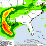
For the Lake Houston Area, NWS predicts potential for moderate flooding rain

Potential Impacts Include:
- Moderate rainfall flooding may prompt several evacuations and rescues.
- Rivers and tributaries may quickly become swollen with swifter currents and overspill their banks in a few places, especially in usually vulnerable spots. Small streams, creeks, canals, and ditches overflow.
- Flood waters can enter some structures or weaken foundations. Several places may experience expanded areas of rapid inundation at underpasses, low-lying spots, and poor drainage areas. Some streets and parking lots take on moving water as storm drains and retention ponds overflow. Driving conditions become hazardous. Some road and bridge closures.
For Lake Houston Area, NWS Predicts Winds from 58 to 73 mph

Potential Impacts Include:
- Some damage to roofing and siding materials, along with damage to porches, awnings, carports, and sheds. A few buildings experiencing window, door, and garage door failures. Mobile homes damaged, especially if unanchored. Unsecured lightweight objects become dangerous projectiles.
- Several large trees snapped or uprooted, but with greater numbers in places where trees are shallow rooted. Several fences and roadway signs blown over.
- Some roads impassable from large debris, and more within urban or heavily wooded places. A few bridges, causeways, and access routes impassable.
- Scattered power and communications outages, but more prevalent in areas with above ground lines.
…TROPICAL STORM WARNING REMAINS IN EFFECT…
West of Lake Houston, the threat level decreases. Between Dayton and Liberty, it increases.
For those closer to the coast, the map also includes storm surge warnings. Also check out the estimates of tornado threats.
The latest satellite images show Laura just off the coast. The storm is moving north at about 15 miles per hour.

No Lake Conroe Release Anticipated Before Storm
In other hurricane related news, the SJRA just issued a press release stating that:
“SJRA is operating under standard protocols for a severe weather event and will be onsite at Lake Conroe throughout the night and into Thursday.
Lake Conroe remains about 15 inches low, and based on the current forecast, no reservoir releases are expected.“
Posted by Bob Rehak on 8/26/2020 at 11:00 a.m. based on estimates from the National Weather Service.
1093 Days since Hurricane Harvey