Tag Archive for: tornado

April 10th Storm Dumps 12-17 Inches in 12 Hours East of Houston

The April 10th storm that swept through Houston during the early morning hours dumped amazing amounts of rainfall just east of here.

A report received today from Harris County Meteorologist Jeff Lindner says that the April 10th storm dumped 12-17 inches of rain in a 12 hour period in a swatch across East Texas. The result: widespread, catastrophic flooding in parts of Newton, Jasper, Hardin, and Tyler Counties.

A peak total of 17.68 inches was recorded near Kirbyville, TX. Lindner characterized the totals as “insanely high.” In fact, NOAA’s Atlas 14 rainfall chart for Kirbyville lists a 12-hour/17-inch rainfall as a 1000-year event.

NOAA’s Atlas 14 Rainfall Probability Statistics for Kirbyville, TX area.

Late yesterday morning, Weather.com reported that a Disaster Declaration had been issued for Jasper County, Texas. Officials there said that multiple people were rescued from both homes and vehicles due to flooding in the area. “The city of Kirbyville remains underwater.”

April 10th Storm Rivaled Tax Day Storm

The squall line which started near the Rio Grande around 9:30 pm Monday evening traveled some 800 miles reaching the FL panhandle producing wind damage and tornadoes along much of the path.

According to Lindner, “This should serve as a reminder that when the flash flood ingredients are in place around here, it can rain, and rain a lot, in a very short period of time.”

Some 12-hour rainfall totals were near those of the April 2016 (Tax Day) Storm. It is worth noting that yesterday’s event took place at nearly the same time of year.

The flash flooding developed along a stalled low-level convergence boundary. An influx of tropical moisture and repeat cell training anchored on the boundary for much of the night fed the high totals.

“This was a classic meso-scale flash-flood event common along the Gulf coast,” said Lindner.

High resolution computer models suggested the heaviest rainfall would occur over central Louisiana. So this caught many forecasters off guard.
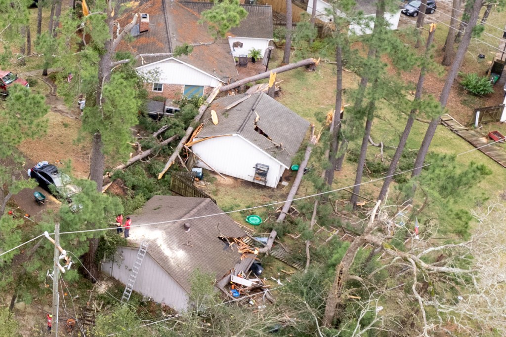
Tornadoes, Too

The April 10th storm also produced several tornados including one that briefly touched down south of the Katy Freeway inside of SH99.

EF-1 tornado with maximum wind speeds of 90mph touched down around 2:45 am just west of Mason Rd south of Kingsland. It tracked generally eastward toward Fry Rd.

Damage along the east side of Mason Rd was consistent with low-end EF-1 rating. It included lifting and movement of vehicles in a parking lot, the complete failure and collapse of a Tire Shop, blow-out of windows, and failure of roofing on a nearby strip center.

The storm also lofted a commercial AC unit on the top of the strip center and dumped it in the parking lot.

Wind damage continued eastward along and south of Cimarron Pkwy toward Fry Rd.

The wind snapped and uprooted numerous trees through this area and blew down several fences. A corridor of damage continued eastward, but there was little evidence of a full fledged tornado at that point.

Winds estimates in the residential areas between Mason and Fry Rd were on the order of 65-75mph – an EF-0 rating.

Lindner says that these types of tornadoes are common along the leading edge of intense squall lines. Bows or “kinks” develop in the line, enhancing low-level rotation, which results in quick, short-lived, weak tornados. 

The path lasted 1.7 miles and width ranged from 300 to 400 yards.

The maximum intensity reached EF-1 (90mph) on east side of Mason Road.

Maximum Winds

High winds were reported in numerous places through the Houston/Galveston area.

  • 62 MPH at Hooks Airport in Tomball
  • 55-59 MPH in Galveston, Pearland, Palacios and Fulshear
  • 65 MPH in Dickinson
  • 71 MPH in San Leon
  • 72 MPH at an oil platform offshore High Island

Lake Houston Area

The Harris County Flood Warning System recorded:

  • 1.96 inches at US59 and the West Fork.
  • 2.16 inches at West Lake Houston Parkway and the West Fork.
  • 3.00 inches in Huffman
  • 4.92 inches farther east along Luce Bayou at 321.

Notice the trend as you move farther east?

All things considered, the Lake Houston Area lucked out. We got enough rain to green up the grass, but not so much that people flooded.

Posted by Bob Rehak on 4/11/2024

2418 Days since Hurricane Harvey

Tornado Gone But Not Forgotten

At approximately 1:30 AM on January 9, 2022, a tornado swept through Kingwood. Hard hit areas included Forest Cove and Trailwood Villages. The supercells that spawned the EF-1 Tornado also dumped approximately 5 inches of rain that morning. When the rain stopped, I ventured out and found cleanup crews already clogging the streets. I drove through the same areas today to gage the progress of repairs.

Tornado Aftermath Remains

Many homes have been fixed, re-roofed and re-painted. But many blue tarps still remain. Roofers will not soon run out of business.

And I saw two empty foundations where it looked like homeowners decided to start over.

The scenes were a testament to the power of nature and the determination of humankind.

Among the memorable scenes that remain, these two stand out.

Top of tree has hung upside down on utility wire for a month.
tornado aftermath in forest cove
Home devastated by January tornado in Forest Cove.

Tornado, Like Harvey, a Defining Moment

To me, the first shot symbolizes the chaotic and capricious nature of a tornado.

And the second symbolizes the overwhelming heartbreak. A home sawed in half by a fallen tree. Torrential rains streaming through the breach. Ceilings caving in, destroying contents. Mangled garage door. Fallen timber. Sawed, but not removed. This was an ordeal that would have tested the strongest among us.

It reminds me of Harvey’s aftermath. As I drive around Kingwood, I still see reminders. Vacant homes. Ongoing repairs. Shops that remain empty. Businesses struggling to recover. Still.

Physical Vs. Emotional Recovery

The repairs may be over for most. But the financial and emotional scars will last a lifetime. Trials such as these become defining moments. For people. And for communities. They represent a fork in the tree of life. They can build character. Or destroy futures.

The temptation after making physical repairs is to repress the pain of the past and move on with life. But I hope we never forget those who still struggle.

Posted by Bob Rehak on February 10, 2022

1626 Days since Hurricane Harvey and 31 since the January Tornado

HCFCD Report Shows Kingwood Tornado was Widest, Longest, Strongest

Today, Jeff Lindner, Harris County’s meteorologist issued a report on last weekend’s (1/8/22 – 1/9/22) storm. One of the more interesting findings: According to the National Weather Service, the Kingwood tornado was the widest, strongest and longest of five that touched down in Harris County. See below.

EF stands for Enhanced Fujita Rating Scale, a table used to compare tornado winds. All these tornadoes ranked on the low end of the scale which goes up to EF-5. The scale considers 0 and 1 as weak tornadoes.

Wealth of Detail Beyond ReduceFlooding Reports

Lindner’s report confirms my “after-action” reports, but adds a wealth of details.

For instance:

  • Rainfall rates of 2-3 inches/hour were common in the slow-moving training thunderstorms.
  • That led to rapid and significant street flooding, and rises on area creeks and bayous.
  • The highest measured discharge (streamflow) rate was in Greens Bayou at Mount Houston Parkway – 7,067 cubic feet per second.

Lindner found that certain areas experienced 2- to 10-year rains based on Atlas-14 exceedance probabilities. Based on 1- to 3-hour rainfall rates, those included middle Buffalo Bayou, Luce Bayou, middle and upper Halls Bayou, middle Greens Bayou, middle and lower White Oak Bayou, and the lower portion of the East Fork of the San Jacinto River. However, based on 12- to 24-hour rates, all impacted watersheds experience 2- to 5-year rains.

Because the storms trained perpendicular to the direction of most bayous, the rainfall within their watersheds varied greatly. For instance:

  • Greens Bayou received on 0.9 inches at Mount Houston Parkway, but 6.2 inches at US59.
  • Buffalo Bayou received 5.2 inches in places and 0.2 in others – a 26X difference.

Like all of the work that comes out of Lindner’s department, the documentation is meticulous.

House Flooding Estimates

Contrary to previous reports, some house flooding did occur. It happened along Brickhouse Gully on the west side of Bingle Rd. Approximately 6-8 structures experienced flooding to depths of 4.0-6.0 inches.

Says Lindner, “Other isolated structures may have flooded in portions of Spring Branch due to the intense rainfall rates overwhelming street and local drainage systems. A few houses also flooded along Valley Stream downstream (east) of I-45 along Halls Bayou.”

Alarms Triggered

Unfortunately, Lindner doesn’t offer much more information about the Kingwood tornado at this time. Nor does he cover flooding in surrounding areas, such as Liberty County. However, the storm did set off a number of alarms.

The storm triggered 26 rainfall alarms when gages received more than an inch of rain in 15-minutes.

Rising water triggered 14 flood warnings when streams reached 3 feet below bankfull.

For detailed maps, rainfall rates, and exceedance statistics at dozens of locations, see Lindner’s full report. Note: on major storms, Lindner often issues an immediate report and a final report several weeks later. This report falls into the “immediate” category. For future reference, you can also find this report under the Major Storms tab on the reports page.

Posted by Bob Rehak on 1/13/22

1598 Days since Hurricane Harvey

Pics of Tornado Damage in Kingwood/Forest Cove

Early Sunday morning on January 9, 2022, an EF-1 tornado touched down along the Kingwood Diversion Ditch between Hamblen and Kingwood Drive. It damaged trees and homes on both sides of the ditch for several blocks. By early afternoon, tree crews were swarming over the area, making the streets barely passable.

Tornado or Just Strong Winds?

I asked one of the crews if they were sure a tornado caused the damage. They said yes, based on the type of damage they saw. The tops of trees had been twisted off like screw caps. See photos below taken on Sunday afternoon after the storm cleared out.

Note two garages and corner of one home damaged by toppled trees east of ditch.

While some trees were uprooted, the vast majority of the damage involved “topped trees.” Had straight line winds been the cause, you would see more uprooted trees. The damage would have been more widespread. And the trees would have been pushed down in a uniform direction rather than scattered like pick-up sticks.

Looking south along Kingwood Diversion Ditch. Note eight topped trees left of the ditch and one of the tops hanging from a wire over the ditch.
West of ditch on Forest Cove side. Note damaged garages, back corner of home, and trees still hanging from wires.
Close up of topped tree and blown-over fence.
Portion of fallen tree thrown through fence by winds.
Forlorn homeowner on crushed gable. “Where do I go from here?”

ABC-13 confirmed the strength of the tornado on its evening news tonight. According to ABC, the tornado came through at approximately 1:30 AM. According to residents I spoke to, the noise was deafening and pets started acting nervous about that time.

Dogs Knew Before You Did

This article from Psychology Today explains that dogs’ hearing is four times more sensitive than humans’. That means they can hear things four times farther away – sooner than we can. Canine hearing also picks up higher pitched sounds. If the noise sounds deafening to you, think how painful it must be for your pooch.

I live near Kingwood High School two miles away. At precisely 1:30, my dog started whimpering, trembling, and tried to jump in bed with me.

Storm Totals Compared to Record and Climate Norm

For the record, the storm that started Saturday afternoon and ended early Sunday morning dumped about 4.96 inches in my rain gage. Jeff Miller, an Elm Grove resident said he had 5.5 inches in his.

These are unusually high amounts for January. The all time record for January 8 was 5.89 inches, set in 1891, 130 years ago! Houston usually receives 3.4 inches for the whole month of January. Plum Grove on the East Fork received 6.88 inches in this storm – more than double the monthly average for the Houston area. Luce Bayou on 321 in Liberty County received an incredible 8.56 inches in the storm. Had either of those locations been the official recording station, this storm would have gone down in history.

Posted by Bob Rehak on 1/9/2022

1594 Days since Hurricane Harvey