Tag Archive for: mouth bar

Army Corps Now 70% Complete with Its Portion of Mouth Bar Dredging

The Army Corps has released a new summary of its progress on dredging the mouth bar. The report indicates that Great Lakes, the contractor is now 70% complete. They have dredged 350,000 out of 500,000 cubic yards.

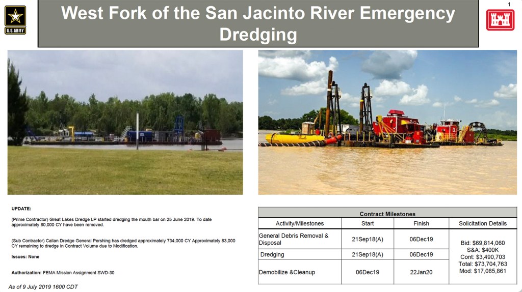
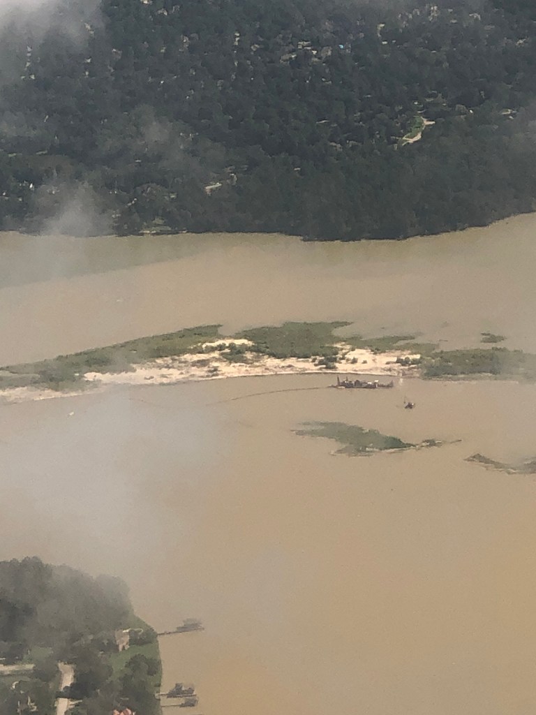
Great Lakes started dredging the mouth bar on June 25th, 2019, as part of a $17,085,861 extension of the original contract (FEMA mission assignment SWD-30).

Current area of operation is the blue area on the far right. Sediment removed from that area is being pumped 10 miles back upstream to Placement Area #2, a sand mine near Kingwood College, on the far left.

Between the start of mouth bar dredging and August 12, Great Lakes dredged an average of 6,363 cubic yards per day. If they can keep that pace up, they should be done by approximately Labor Day – three months ahead of schedule. That’s HALF the predicted time.

Remainder of Project Still Not Decided

What comes next? That still has not been finalized. City, County and State officials have been meeting in the background to determine that. The Army Corps still has not accepted or rejected Berry Madden’s property as a third placement area. And the $30 million appropriated by the State for mouth bar dredging won’t even become available until September 1st.

Meanwhile, Callan Marine, the subcontractor from the original West Fork Emergency Dredging job has pulled its equipment back to the dock opposite Forest Cove. However, Callan has not yet started disassembling its equipment and removing it from the river. According to Houston City Councilman Dave Martin, Callan has agreed to stay temporarily while officials attempt to work out details for the next phase of dredging.

RD Kissling and Tim Garfield, two local geologists who first brought the mouth bar issue to the public’s attention, estimate that 500,000 cubic yards is about one-fourth of the total sediment that must be removed to fully restore conveyance of the West Fork.

How Shallow is It?

The Corps has not yet released (or even developed) plans for mouth bar dredging. We do know the volume they intend to remove, and the general area they intend to remove it from. However, they have refused to divulge how much of a dent their efforts will make in solving the problem.

This photo of a Kings River resident wading across the river shows how shallow it is near the orange channel marker. This resident says boats “beach” behind his property almost every day. Note: Deeper pockets may exist, especially near dredging equipment. The risk of drowning is real. Do not let children attempt this. Photo taken Sunday, August 10, 2019.
The resident made it almost to the channel marker without getting his shorts wet. Shot taken with 6X telephoto lens.
The lake/river within this area averages two to three feet deep. 500,000 cubic yards would lower the average level by another three feet as this calculation shows.

Problem With Stopping after 500,000 CY

The problem with stopping after the Corps finishes its 500,000 cubic yards is that the river behind this area is much deeper. Where the Corps stopped dredging just past Kings Harbor, the river is now 25-30 feet deep. And places are even deeper according to fishermen. That means water coming downriver will be forced to flow uphill in this area. That will force it to slow down and more sediment will rapidly drop out of suspension. Some experts have suggested dredging a deep channel through this area to help restore full conveyance of the river. However, the Army Corps intends to stop after 500,000 cubic yards.

How Army Corps Sees its Role

The Army Corps has prepared a series of FAQs that represent its position on the remainder of mouth bar dredging. Among them:

Q: What is USACE Galveston District’s plan for the rest of the mouth bar?

A. There is no additional work planned for the mouth bar. The current plan for the modification addressing material near the mouth bar can be found on the placemat. USACE Galveston District has no authority to conduct any additional work in the West Fork of the San Jacinto River or Lake Houston. The San Jacinto River is not an authorized federal waterway, the Corps of Engineers dredging operations are currently limited to dredging Harvey-related material. The ongoing work under the contract modification will remove the remainder of material attributable directly to Hurricane Harvey. The sedimentation from recurring annual flows are not within USACE Galveston District’s mission assignment from FEMA. Water flows on the West Fork of San Jacinto River were restored to pre-Harvey levels in December 2018.”

Q: Who can the public contact for additional concerns with the maintenance of the San Jacinto River?

A. For concerns with the maintenance of the San Jacinto River, please contact Harris County Flood Control District, the San Jacinto River Authority and the City of Houston.”

Punt!

Meanwhile the City is still arguing with the Corps about how they arrived at 500,000 cubic yards. More on that later. I have obtained the Corps’ estimate through a FOIA request to the City of Houston. It raises many questions that I am still trying to sort through. More on that later.

Posted by Bob Rehak on August 14, 2019

715 Days since Hurricane Harvey

Government Gone Wild: Army Corp Refuses to Release Dredging Documents that Explain Decisions, Delays

The Army Corps has refused to release documents that explain key decisions, delays and plans related to West Fork mouth bar dredging, and a potential placement area for the spoils. At issue are the Corps’ decisions to dredge only 500,000 cubic yards from the area of the mouth bar and to delay approval of the City’s proposed placement area for long-term dredging.

As a result of a Freedom of Information Act (FOIA) request related to these decisions, I also learned that the Corps:

  • Is dredging near the mouth bar without a plan
  • Is almost done with the mouth bar project and hopes to have a plan before it finishes
  • Has repeatedly delayed a decision on a new placement area that could have saved millions of tax dollars.

Meanwhile, the Corps continues sending sediment to a mine that leaks it back into the river. That mine – in the floodway – has a dubious environmental record at best. This seems to be a case of Government Gone Wild.

Dueling Studies Offer Different Opinions of Harvey-related Mouth Bar Volume

The City of Houston and Army Corps have reportedly argued for a year or more about how much sediment Harvey deposited in the mouth bar. Late last year, FEMA required the City to perform a core-sample study using something called the Stockton Protocol. The City hired Tetra Tech to do it. And Tetra Tech concluded Harvey deposited 1.4 million cubic yards. Here is their study.

The Corps, however, evidently did not buy the results. The Corps conducted another study for FEMA using a different protocol. It concluded Harvey deposited 500,000 cubic yards.

The Corps, however, refused to release the results of that study for public review.

FEMA and the Corps went ahead and hired Great Lakes to dredge that volume from the mouth bar. That job is now more than half complete.

As part of their refusal to release their study, they cited the need to keep “pre-decision” information confidential so that inter- and intra-agency personnel could debate the merits of proposals freely. I get that. What I don’t get is how they justify this as “pre-decision.” The job is almost complete!

Dredging Without a Plan

While inventorying the documents that the Corps DID send me, I also discovered that they are now dredging the mouth bar area – without a plan. I know this because I requested the plan and they did not supply it. A Corps representative then explained that they are still working on the plan. They hope to have it done before they complete the $17 million job.

Wasteful Spending?

The Corps could be saving much of that money by using Berry Madden’s property near Kings Lake Estates as a disposal site. That’s because they need more than 5,000 gallons of diesel per day and two extra boosters (plus their crews) to pump sediment 10 miles upriver to an old West Fork sand mine in the floodway.

At the current price of diesel (about $3/gallon), that’s about $15,000 per day for fuel alone. More than $100,000 per week. And more than $400,000 per month. Waaaaay more than the limit on my gas cards. So what does the Corps get for all that?

Dike Breaches of Placement Area in Floodway

Minor floods last December breached the dike of that sand mine at least three times. Sediment continues to sweep out of the mine.

Placement Area #2 near Kingwood College on West Fork. This image is from February, but it is the same mine, whose dikes were breached in December.

It has caused additional shoaling (see below) that will need to be removed some day near the I-69 bridge. It even buried Great Lakes pipes, causing cost overruns for Phase 1.

Shoaling has become so bad through this reach of the river that it buried Great Lakes pipeline, resulting in cost overruns.

A year ago, this same mine was caught on camera deliberately sending its process water straight into the West Fork.

Video provided to ReduceFlooding.Com. Source wishes to remain anonymous.

Yet, while approving this site, the Corps reportedly has environmental concerns over a much closer disposal site that would require less fuel and fewer boosters. It’s also on higher ground and out of the floodway. It’s Berry Madden’s property in Humble immediately west of Kings Lake Estates between the West Fork and 1960.

Five different proposed placement areas on Madden property avoid wetlands (the cross-hatched areas).

The Corps may or may not have good reasons for disliking the property, but they won’t reveal them whatever they are.

After more than a year of environmental and archeological studies costing Madden more than $100,000, the Corps still has not approved or rejected his property. Nor have they explained delays in approving or rejecting it. The documents that the Corps DID supply show that they are throwing one obstacle after another in Madden’s path. Despite the fact that he’s on higher ground and farther from the river than the current placement area.

Meanwhile, the Corps subsidizes the sub-optimal sand mine/placement area above. Go figure!

Potential Setback for Future Dredging

One of the consequences of NOT having an approved site to store additional spoils is that it could delay future phases of dredging. Those potentially include:

  • Additional mouth bar dredging
  • 59 to River Grove Park
  • Maintenance dredging
  • Mouths of ditches such as Ben’s Branch

FOIA Scorecard

I filed my Freedom of Information Act (FOIA) request with the Army Corps 50 days ago. I requested:

  • Their plans for mouth-bar dredging
  • Conference reports of meetings where the mouth bar was discussed
  • Documents relating to the approval of Berry Madden’s property in Humble as a potential storage site.

About a month ago, they requested a clarification. “What do you mean by ‘plans’?” Seriously! The U.S. Army Corps of Engineers needed to have the concept of plans explained????!!!

After more delays and excuses, five days ago, I received a compact disk in the mail with approximately 800 total pages of material. The Corps:

  • OMITTED any mouth-bar plans.
  • OMITTED the Corps study that contradicted the Tetra Tech study.
  • WITHHELD 118 pages of material that could have explained their decision.
  • REDACTED key correspondence relating to Madden’s property.
  • SUBSTITUTED dredging status reports from contractor meetings for conference reports of meetings among City, State and Federal officials where decisions about the mouth bar were considered.

Government Gone Wild

After several phone calls in which I tried to cajole them into supplying the Corps’ study, I received another email from the Corps. It said that they considered my original FOIA request closed. They then asked me to submit another one for the same material that I requested in June. They seem to be treating this as a national-security issue, not a public-safety issue. Why?

Here’s the explanation from the Corps. The letter claims that they need to keep pre-decision information secret in order to foster free discussion between its employees and other government agencies and to avoid confusing the public.

Unfortunately, that does not allow informed discussion among the public, whose safety is at stake. Nor does it recognize the fact that they have already made a decision, i.e, to dredge 500,000 cubic yards and have half-completed the project. So how does this qualify as “pre-decisional”?

You’ll have to ask the man who signed this letter.

He has the title “Initial Denial Authority.” How many levels are there?

In my opinion, this is clearly a government agency out of control. The Corps has made a decision to dredge only 500,000 cubic yards – despite scientific evidence supporting a higher volume of 1.4 million cubic yards. And that scientific evidence was acquired using a protocol that the CORPS AND FEMA DEMANDED.

Who Will Pick Up the Pieces?

That leaves the State, County, City and the public in the lurch. Maybe a Congressional investigation could sort this out. That’s what it will take.

At this point, it’s not clear how, when or if the mouth-bar job will be finished. Five hundred thousand cubic yards is a small fraction of what needs to be removed to restore conveyance to the river.

It’s also not clear how many more hurdles the Corps will put in the way of a placement area farther from the river on higher ground. Or why.

A curtain of secrecy has descended upon this job. I will continue to follow the story. The public has a right to know.

Open Offer to Corps to Rebut Criticisms

If the Corps feels I have criticized it unjustly, I invite a spokesperson to explain the Corps point of view. I promise to reprint the rebuttal verbatim.

Posted by Bob Rehak on 8/9/2019

710 Days since Hurricane Harvey

The thoughts in this post represent my opinions on matters of public interest and safety. They are protected by the First Amendment of the U.S. Constitution and the Anti-SLAPP Statute of the Great State of Texas.

First Phase of West Fork Dredging Completed

The Army Corps has completed the original scope of its West Fork Emergency Dredging Project. Great Lakes, the prime contractor, finished its portion of the job in mid-April. This week, Callan Marine, the subcontractor, finished its portion of the dredging.

Subcontractor Callan Marine Now Demobilizing

Callan has already begun demobilizing. So far, the company has unhooked its dredge from its pipeline and is removing its booster pumps and other equipment from the river. Callan should have all of its equipment back at the command site dock by this weekend.

Yesterday, Keith Jordan, a resident of Kings Lake Estates, greeted the news joyfully. “Hallelujah! It’s simply amazing how quiet it is tonight.  It’s been a long 8 months!” Jordan had a booster pump anchored behind his home the entire time and complained several times to the Corps about noise.

Callan operated the blue dredge that worked the area downstream from the West Lake Houston Parkway bridge since approximately January.

Callan dredge near King’s Harbor on Jan. 31, 2019. West Lake Houston Parkway Bridge in background. Callan booster pump on far side of bridge.

Mouth Bar Contract Extension Ahead of Schedule

In other news, Great Lakes is far ahead of schedule on a contract extension. The extension is a separate mission assignment from FEMA to the Corps for slightly more than $17 million. It involves dredging 500,000 cubic yards of sediment from the mouth bar. The Corps originally thought the extension would take until January, 2020. However, at the current rate, Great Lakes could finish next month – in less than half the time predicted.

Five-hundred thousand cubic yards will barely scratch the surface of what needs to be removed and may not even be sufficient to cut a channel through the mouth bar area, thus leaving most of the mouth bar intact. It is unclear at this time what the plans are to restore conveyance through this area of the West Fork.

Current Dredging Photos from Carolyn Daniel

A reader, Carolyn Daniel, sent me several pictures taken earlier this week from the window of an airplane as it descended into Bush Intercontinental Airport. They show the Great Lakes Dredge south of the mouth bar. The company also removed vegetation from leading edge of the mouth bar itself. Perhaps they hoped that river currents could help erode the bar which contains far more than 500,000 cubic yards.

Great Lakes Dredge near Mouth Bar with Kingwood in background. Looking north. Town Center is on left and Kings Point on the right. Photo courtesy of Carolyn Daniel. Taken 8/5/2019.
Seconds later, as her plane descended, Carolyn Daniel grabbed this shot of mouth bar dredging. Also looking north, it shows Atascocita Point in the foreground and Fosters Mill and Kings Point in the background.

These images illustrate the enormity of the task ahead and the need to be ruthlessly efficient with resources and time.

Challenges Ahead

Tomorrow, I will look at some of the challenges ahead, and some of the obstacles to restoring conveyance.

Posted by Bob Rehak on 8/8/2019 with photos from Carolyn Daniel

709 Days since Hurricane Harvey

What Rivers Looked Like Before the EPA Regulated Water Pollution

Something happened today that made me realize how, as a society, we are losing sight of the things that caused us to regulate the environment 50 years ago. As a result, some bad history could repeat itself

After seeing yesterday’s post about the West Fork mouth bar, a reader named Suzanne Kite sent me a link to an article on BusinessInsider.com. Little did she know that – for me – it would be a free ride on an emotional roller coaster in the wayback machine. The article talked about pollution of America’s rivers before the EPA…and focused on Cleveland, Ohio.

How Physical Landscape Shaped Political Landscape

About two thirds of Americans alive today had not yet been born when Cleveland’s Cuyahoga River caught fire in 1969. So they have no memory of the event that helped give birth to the EPA.

The Cuyahoga River caught fire a total of 13 times dating back to 1868. It was one of the most polluted rivers in America. Photo: Cleveland State University Library.

I remember it vividly. I was born in Cleveland, not far from the Cuyahoga River. Some of my earliest and happiest memories of childhood revolved around clam bakes with my family in Lake Erie in the early 1950s. But then we had to stop. The clams, they said, were contaminated with pollution from the Cuyahoga.

When the Cuyahoga caught fire, it came to symbolize out-of-control pollution. It became the spark that led to the creation of the EPA.

Says Aylin Woodward, author of the BusinessInsider.com article, “The disaster prompted a public outcry that in part led to the formation of the US Environmental Protection Agency (EPA) in 1970. The EPA was charged with regulating the country’s polluted air and waterways…”

“Documerica” Photo Archives

She continued. “Soon after its founding, the agency dispatched 100 photographers to capture the US’ environmental issues as part of a photo project called Documerica. The photographers took about 81,000 images, more than 20,000 of which were archived. At least 15,000 have been digitized by the National Archives, and the images now function as a kind of time capsule…”

The archives actually show many photographs of pollution coming from sand and gravel mines.

If you like looking at old photos, you will find this collection fascinating. This BusinessInsider article shows how people and businesses back then used rivers as sewers. A separate article in the Smithsonian goes into even more detail on the Cuyahoga.

Environmental Degradation Preceded Population Loss

Cleveland was a once-proud and booming city that symbolized America’s industrial might. In 1950, it ranked as the seventh largest city in the country. Houston at the time ranked only 14th with a little more than half of Cleveland’s population. In the latest census (2010), however…

Cleveland ranked 45th and had lost more than half the population it had 60 years earlier. It continues to lose population at an alarming rate.

San Jacinto Problems Not New

An alarming number of readers who saw yesterday’s post about the San Jacinto West Fork mouth bar commented on the massive amount of sediment pollution. They believe that not enough is being done to reduce the amount of sediment coming downstream.

Mouth bar blocking the West Fork of the San Jacinto. Photographed from a drone operated by Franz Willette of BCAeronautics.

Not all, but much of that sediment, in my opinion, came from approximately 20 square miles of sand mines upstream that were inundated by three so-called 500-year storms in 2015, 2016 and 2017. The rate of deposition has increased exponentially as you can see in the graph below.

Sudden exponential growth in mouth bar volume. Graph compiled by RD Kissling from Google Earth historical satellite photos.

FEMA believes that at least 500,000 cubic yards of sediment came downstream during Harvey. The City of Houston believes the number is closer to 1.4 million cubic yards.

All of that sediment pollution threatens the main source of the City’s drinking water by reducing its capacity.

Let’s Learn from History

The point of all this: history is repeating itself.

In 2006, American Rivers named the San Jacinto one of the 10 most endangered rivers in America… because of sand mining. And it has only become worse since then.

These developments make me fearful of the future that my children and grandchildren will inherit. If you share these feelings, please continue to apply pressure on elected representatives to push sand mines further back from the river.

What good is cheap concrete if the environment has become so degraded that people move elsewhere?

Posted by Bob Rehak on 7/13/2019

684 Days since Hurricane Harvey

Weekly Mouth Bar Dredging Update with Images from Carolyn Daniel, Kendall Taft, Franz Willette of BCAeronautics, and the Army Corps

We learned a little bit more this week about the next phase of dredging. Several graphics (below) released by the Corps summarize modifications to the Emergency West Fork Debris Removal Project.

What We Confirmed and Learned

We confirmed that:

  • Great Lakes, the prime contractor on the original job, will be the only contractor on the Corps portion of the contract extension
  • Great Lakes will pump sediment all the way upstream to Placement Area 2
  • The Corps intends to dredge 500,000 cubic yards in the area of the mouth bar.

We learned that:

  • The original contract contingency allotment of approximately $3.5 million was used up, most likely by additional sediment washed downstream during floods in December, January, February, May and June.
  • Callan, the subcontractor for phase one, has approximately 83,000 cubic yards to dredge due to modification of the original contract.
  • Dredging an additional 500,000 cubic yards will cost another $17,085,861
  • The FEMA/Corps portion of the dredging should finish by December 6, 2019
  • Demobilization and cleanup will take until Jan. 22, 2020
  • This is FEMA mission assignment SWD-30
  • Great Lakes started dredging the mouth bar on June 25th
  • Great Lakes will dredge a wide area but not go all the way to the FM1960 bridge.

Corps Releases Summary of Project and Extension(s)

I compiled the information above from a PDF developed by The Army Corps. They released it on July 9.

First page of a 2-page PDF released by the Corps on July 9.
Second page of a 2-page PDF. Army Corps summary of Emergency West Fork Dredging project. For a high-resolution PDF, click here.

To calculate the depth of dredging in that blue area to the right, I simulated the outline in Google Earth and found that it roughly equals 500,000 square yards. That means if they dredge this whole area, they will reduce the river bed by approximately 3 feet. The area already averages 2-3 feet deep. That means the river will be roughly 6 feet deep through this reach when the Corps finishes its portion of the job.

The area outlined by Corps is approximately 500,000 square yards.
Where Callan will finish dredging near Kings Harbor, the depth will be approximately 22.5 feet.

However, upstream, Callan is dredging to a depth of 22.5 feet. Thus, creating a continuous gradient along the river bottom would require dredging approximately another 16 feet deeper in the same area…and that wouldn’t even get you to the FM1960 bridge. Also, note the gap in the graphic between where Callan will finish its portion of Phase One and Great Lakes will start mouth bar dredging.

Unknowns

It is unclear at this point who will dredge the rest of the material that needs to be removed to restore conveyance of the West Fork. Neither the City, County, nor State have yet announced their plans. We don’t know:

  • Where they will dredge
  • How deep they will go
  • Where they will place the material
  • How much it will all cost, or
  • When they plan to do it.

In the meantime, here are two dramatic sequences of photos plus a video submitted by readers this week. They show what the start of mouth bar dredging looked like from the air and water.

Carolyn Daniel Mouth Bar Shots from Airplane Landing at IAH

Carolyn Daniel submitted these shots of the mouth bar and dredging activity taken from her airplane window while on a landing approach to Bush Intercontinental Airport.

On approach to IAH. FM 1960 at bottom of frame. East Fork of San Jacinto upper right and West Fork on the left. Kings Point and Royal Shores between them. Image courtesy of Carolyn Daniel.
Can you spot East End Park? Kingwood Drive? Town Center? All are visible in this shot by Carolyn Daniel.
Mouth bar of west fork with dredge. Photo courtesy of Carolyn Daniel. Note the large Triple-P sand mine near the top of the frame in Porter.
Mouth bar of San Jacinto West Fork with Great Lakes Dredge. Image courtesy of Carolyn Daniel.
Mouth bar of West Fork with dredge. Atascocita Point on left in foreground. Fosters Mill and Kings Point in background. Photo Courtesy of Carolyn Daniel.
Through the clouds. While landing at Bush Intercontinental Airport. Mouth bar of San Jacinto West Fork with Great Lakes Dredge. Image courtesy of Carolyn Daniel.

Franz Willett Drone Shots Courtesy of BCAeronautics

Franz Willette runs a company called BCAeronautics that uses drones in mapping, inspections, roofing analyses, site surveys, and 3D modeling. He did not have clouds to contend with and could shoot safely from a much lower elevation. Willette is FAA certified.

West Fork Mouth Bar with Great Lakes Dredge. Drone image courtesy of Franz Willette, BCAeronautics.
West Fork Mouth Bar with Great Lakes Dredge. Drone image courtesy of Franz Willette, BCAeronautics. Great Lakes should dredge those two small islands in the background.
West Fork Mouth Bar with Great Lakes Dredge. Looking south toward the FM1960 Bridge. Drone image courtesy of Franz Willette, BCAeronautics.
West Fork Mouth Bar with Great Lakes Dredge. Drone image courtesy of Franz Willette, BCAeronautics.

Kendall Taft Video

Video courtesy of Kendall Taft. Shot from south of mouth bar looking north.
Shows how shallow the water is and how vast the expanse is.

I hope to post updates weekly on this project. So readers, please help. Submit your images through the submissions page of this web site. My thanks to Carolyn Daniel, Franz Willette, BCAeronautics and Kendall Taft.

Posted by Bob Rehak on 7/13/2019 with help from Carolyn Daniel, Franz Willette, BCAeronautics and Kendall Taft.

683 Days since Hurricane Harvey

Mouth Bar Dredge Idle Over Holiday Weekend; Not Much Progress Yet

New images by RD Kissling, a Lake-Houston-area geologist and canoeist, show two things. The Great Lakes dredge near the mouth bar sat idle this holiday weekend. Also Great Lakes has not made much progress yet.

Dredge seems to be hugging the south shore of the mouth bar. An excavator has removed vegetation and loosened sand in that area.

Kissling Video Underscores Immensity of Undertaking

Also, Kissling shot more video. This 32-second clip shows him standing in less-than-knee-deep water approximately 300 yards from the mouth bar. This video dramatizes the immensity of the task at hand. It also shows where the channel currently lies relative to the mouth bar itself.

Video showing RD Kissling in shin-deep water 300 yards from the south shore of the mouth bar.

History of Mouth Bar Dredging

The Corps excluded the mouth bar in the first phase of dredging. Instead, it focused on a 2.1 mile stretch upstream. Since the Corps revealed its Phase-One plans, residents have been organizing to ensure dredging through the mouth-bar reach.

Kissling and Tim Garfield, another local geologist first brought the dangers of the mouth bar to the public’s attention. Massive deposits of sand cause water to flow uphill by 30+ feet between the end of Phase-One dredging and the mouth bar. That backs water up during floods. The channel width and depth simply don’t have enough conveyance capacity to move floodwaters through. As a result, the floodwaters slow down, drop their sediment load, enlarge the blockage, and start to spread out overland.

The mouth bar of the West Fork of the San Jacinto. Photo taken two weeks after Harvey.

Clampdown on Communications

Neither the City, County, State, FEMA or Corps have made their plans clear yet. This contrasts with the start of Phase-One dredging when the Corps and City proudly trotted out presentations in community meetings.

I submitted a FOIA request to the Corps for their plans several weeks ago. However, I have not yet received those plans. I did receive a request for clarification asking what I meant by “plans”? I responded that I could not imagine the US Army staging an operation this large and expensive without a plan. They thanked me for the clarification.

The FOIA stalling and clamp down on communication from all parties involved suggests that the Federal government and local authorities have not yet reached a mutually satisfactory agreement. It has been nine months since they announced an agreement in principle after the “everybody-but-Trump” meeting in Austin.

To be fair, this has been a holiday week and many people are on vacation. Perhaps things will become clearer when they return.

To date, the small amount of excavation completed has focused on the edge of the mouth bar itself, not widening or deepening the channel near Atascocita Point. This July 2 Community Impact article suggests that the Corps intends to dredge the edge of the mouth bar but offers no other detail or explanations.

Impact of Dredging on November Elections

With City elections fast approaching, it will be interesting to see if progress – or the lack thereof – affects how the Lake Houston Area votes. We’re running out of time to make reasonable dredging progress before November. With two years in the rear-view mirror since Harvey, I suspect voters will look at performance more than promises when they go to the polls.

In coming weeks, I will post about where the candidates line up on the three major goals for the Lake Houston Area: additional dredging, detention and gates (Plea for DDG). I also hope that this will be the first of weekly reports on mouth bar dredging. So if you are out on the water, please send pics of what you see.

Posted by Bob Rehak on 7/6/2019

676 Days since Hurricane Harvey

Mouth Bar Dredging Begins

It appears that dredging of the mouth bar of the San Jacinto West Fork has officially begun. Two weeks ago, I reported that the Great Lakes dredge had maneuvered into position. Then this weekend, residents started sending me pictures taken from the river showing equipment in operation.

Mouth Bar Imagery from RD Kissling

RD Kissling, a Lake Houston area resident and geologist, who first helped bring the mouth bar to the public’s attention sent me the photo and video below last week. “The dredge is up and running,” he said.

The image with the canoe below, Kissling said, “This is me standing in shin deep water about 200 yards south of the exposed mouth bar, looking north towards the bar and Scenic Shores.  There is another small channel about 20 yards south of me then the bar shoals again.”

Lake Houston Area geologist RD Kissling standing in shin-deep water 200 yards south of the mouth bar. This image, more than any other I have seen, dramatizes how critical the need for dredging has become...and how hilarious the Romerica proposal is to build a marina for more than 600 40-foot yachts.
Video shot by RD Kissling from the southernmost exposed portion of the mouth bar.  Starts looking west towards the dredge then swings around to the east.

Mouth Bar Images from Today Shot by Jeff Kristoff

Then Jeff Kristoff, a Kingwood resident, sent me the pictures below today. They show an excavator on the upstream end of the bar and dredging equipment immediately south of the bar. It appears there may be two excavators breaking up vegetative growth and sediment. Farther upstream, near River Grove Park, dredgers reportedly ran into submerged logs that had been covered by sand.

The loops in the pipelines will allow the dredge to maneuver up and downstream as it works. Note first of two excavators in background breaking up vegetation at edge of mouth bar.
Excavators can also be used to more or lift pipe for repairs.

Ultimate Plans Still Not Announced Yet

Exactly where or how much the Corps and its partners plan to dredge has not yet been announced. The Corps last issued a press release for the project on June 10, three weeks ago, and has not yet responded to a Freedom-of-Information-Act request for the dredging plans.

Because it’s hard to believe that the U.S. Army would move on a project this large without a plan, I can only conclude that all parties have not yet reached an agreement on volume and a permit for placement of the sediment.

For the time being, it looks as though the Corps will use Placement Area 2 on Sorters Road…at least initially. Pumping ALL of the sediment 10 miles upstream would hike the cost hugely because it would require at least 5 booster pumps. Each uses 1000 gallons of diesel per day.

For speculation on where and how much they might dredge, see this post.

Posted by Bob Rehak on July 4, 2019, with images and video from RD Kissling and Jeff Kristoff

674 Days since Hurricane Harvey

Living Landscape: San Jacinto River Before Lake Houston and Now

Geologic change happens so slowly, most people won’t live or stay long enough in one place to perceive it. Then something happens to make you crank up the Wayback Machine and look more closely. Yesterday was one of those days for me. The Army Corps announced that it was going to begin dredging part of the West Fork mouth bar area.

That raised the question, “Which part?” That wasn’t announced. So I asked Tim Garfield, retired chief geologist for one of the world’s largest oil companies, what he would do. He felt it was important to re-establish the river’s natural channel. So I asked him where it was. (Spoiler alert: It’s between the mouth bar and Atascocita Point.) But in the process of figuring this out, I learned many more things about the mouth bar and a river I take for granted. I’ll save those for the end.

70 Years of Change on the River

Garfield led me to the Perry-Castañeda Map Collection of Texas Topographic Maps at the UT Library Online. He found this map from 1949 of Moonshine Hill. It’s exactly 70 years old! The 1949 date means we can see where the river was before the dam and lake were built in 1955.

The San Jacinto in 1949 before Lake Houston was impounded in 1955. For a higher resolution version of this map, click here. This map shows what geologists call “the relict channel.”

Kingwood, Atascocita and Huffman Before Settlement

This map shows areas that would eventually become Atascocita, Kingwood, and Huffman. It includes the area where the mouth bar has formed between Kings Point and Atascocita Point.

You can tell a lot by looking at this map. You can tell even more when you superimpose it over a satellite view of the area today in Photoshop. Suddenly, you see how the landscape has changed. In fact, it changed so much that I had problems aligning the two images.

Map Superimposed Over Satellite Image At Varying Opacities

However, the county line and 1960 are still in the same location. So I used those as reference points. Then I varied the opacity in the top layer (the old map) so that you could see more and more of the current landscape. At different percentages, you can see how various features have changed over time.

Here’s what the sequence looks like starting with 1949 and today. I started by cropping tighter on the area of interest, the West Fork where the Corps is dredging. I include several different opacity ratios because some changes become more apparent at one ratio than another.

100% opacity for 1949 map.
0% 1949 and 100% today.
60% 1949 and 40% today.
50% 1949 and 50% today.
33% 1949 and 67% today.
25% 1949 and 75% today.

Most Visible Changes

Starting from the left:

  • In the 33/67 image, notice how the river once meandered near US59 and how much further south it was.
  • In the 50/50 image, notice how much of the Romerica land was swamp in 1949…and still is.
  • In the 75/25 image, notice how much the river migrated north just north of Kings River estates.
  • In the 25/75 image, notice how much area the lake claimed.
  • In the 33/67 image, notice how far north the river has shifted under the West Lake Houston Parkway bridge.
  • In the 33/67 image, notice how Atascocita Point has grown past the relict channel.
  • In the 60/40 image, notice how the mouth bar grew at the confluence of a relict stream bed within the lake and the relict channel of the West Fork. You can also see this pretty clearly in the 25/75 image.
  • In the 25/75 image, notice how the relict West Fork channel used to hug Atascocita Shores.

Key Map

This image shows locations referenced above for those who may not be familiar with them.

Key to locations

Do you see other things that I did not? Please let me know through the contact form on this web site.

As the dredging program moves forward, these maps may also help inform dredging strategy. Stay tuned.

Posted by Bob Rehak on 6/13/2019

653 Days after Hurricane Harvey

Army Corps Moving Forward with Partial Mouth Bar Dredging to Reduce Flood Risk

The Army Corps announced Monday that it will begin dredging approximately 500,000 cubic yards of the giant sand bar at the mouth of the San Jacinto West Fork. It has been linked to flooding in the Humble-Kingwood-Atascocita area. However, previous estimates put the total volume at close to 2 million cubic yards, with the volume due to Harvey at 1.4 million cubic yards.


Text of Press Release

GALVESTON, Texas (June 10, 2019) – The U.S. Army Corps of Engineers Galveston District staff executed a modification to the West Fork San Jacinto River Emergency Debris Removal contract June 7, 2019, to dredge an additional 497,400 cubic yards of material that was deposited in the mouth of the San Jacinto River from Hurricane Harvey.

“This contract modification will ensure a decrease in threats to critical infrastructure and lower the risk to potential loss of life,” said Charles Wheeler, USACE Galveston District project manager. “This is an ongoing contract that is part of a Federal Emergency Management Agency mission assignment.”

According to USACE Galveston District officials, the dredged material will be placed at the existing location referred to as Placement Area 2, which is located approximately 10 miles upriver. The additional dredging is scheduled to be completed by the end of 2019, with the demobilization of the equipment completed by early 2020.


No Mention of Other Partners

The press release does not mention the City of Houston, Harris County, the State of Texas, or Congressman Dan Crenshaw’s office. Most had been negotiating with FEMA and the Corps as late as last Friday.

On two previous occasions, the City announced agreements in principle with FEMA and the Corps. However, the two sides still had many details to work out relating to volume, storage, permitting and cost. The City and FEMA have tried to reach agreement on the volume of sediment deposited by Harvey since last October – eight months.

In February, the City, hired Tetra Tech to collect and analyze core samples from the mouth bar. In late April, Tetra Tech estimated, through a protocol recommended by FEMA, that Harvey deposited 1.4 million cubic yards of sediment at the mouth of the river.

Two Sides Far Apart in Negotiating Volume

The Corps’ announcement reveals just how far apart the two sides were in their volume estimates – about 900,000 cubic yards. That difference means much of the mouth bar area will remain undredged – at least for now.

With approval to remove only about 500,000 cubic yards, the dredgers will have to cut a channel around the mouth bar, most likely on the deeper Atascocita side. Ironically, that would mean leaving behind sand deposited above water by Harvey – a decision that could confuse the public.

Great Lakes Dredge Moving into Position

Great Lakes finished dredging its half of Phase One on April 12, exactly two months ago. The company has waited patiently ever since for the decision that finally came last Friday.

Today, the Great Lakes dredge has anchored near Kings Harbor. Judging by the weeds and logs in the pictures below, it appears that they will have to dredge their way TO the mouth bar. That could use up some of the precious approved volume. It could also take several weeks to position and calibrate all the equipment necessary to pump sediment 10 miles upriver.

Great Lakes Dredge has moved downriver east of West Lake Houston Parkway. It is anchored in front of Raffa’s in Kings Harbor.
Wider shot taken from the pier in Kings Harbor facing west toward the Great Lakes Dredge and the West Lake Houston Parkway bridge.
Callan dredge operating on the other side of the pier. Dredgers are responsible only for work in the channel, not tidying up the shoreline. While taking this shot this morning, I noticed that workers were finally starting to renovate Sharkey’s, one of the most popular restaurants in Kings Harbor before Harvey.

What Comes Next?

Pumping sediment from the mouth bar to PA-2 will require the horsepower of the larger Great Lakes dredge. It will also require several extra booster pumps and miles of additional 24 inch pipeline. The Great Lakes dredge has now moved downstream and is anchored east of the West Lake Houston Parkway bridge near Kings Harbor.

Last week, dredge pipe re-appeared under the 59 bridge after being gone for two months. That fueled rumors that the two sides had finally worked out some kind of deal. At this hour, the mystery is where does the Corps’ decision leave all the other parties in this process? More important, where does it leave the remainder of the mouth bar?

Other Money Available

The state approved an additional $30 million for dredging the mouth bar last week. The county also allocated $10 million in the flood bond approved by voters last year (see item CI-61). That $40 million along with another $18 million committed by the City of Houston would add up to $58 million. In addition to the unspecified sum FEMA is fronting now, that might be enough to remove the entire mouth bar. That could happen one of two ways:

  • The City, Corps, FEMA and TDEM would have to increase the approved volume after the next phase starts or…
  • The City, County and TDEM would have to remove the rest without FEMA and the Corps.

However, money is just part of the problem. The second option might require permitting another placement area. Permitting could delay the project. But permitting a closer placement area might also save money. It gets complicated.

PA 1 is filling up rapidly as the pictures below show. And PA-2 is so far upriver from the mouth bar that would cost extra millions of dollars to use.

Tail end of the Callan dredge pipe empties sediment into an old sand pit off Townsend in Humble.
Several months ago, this was all water. The owner of the pit is now selling sand to an asphalt company and the pit is still filling rapidly.

Easy Way to Save Money

Shortening the distance between the mouth bar and the placement area could reduce the amount of diesel and manpower needed to run the booster bumps. Each booster uses more than one thousand gallons of diesel per day. So costs add up rapidly. That’s why the Corps is still considering other placement areas.

Berry Madden owns several thousand acres south of River Grove Park between the river and FM1960. According to Madden, using his property could save the government $5.5 million in pumping costs. And that’s just on the first 500,000 cubic yards. If 2 million cubic yards is an accurate estimate for the total mouth bar, using Madden’s property could save $22 million. That’s even more than the remobilization costs we were trying to save.

I hope we don’t stretch this out too much longer or make it any more difficult. My truck needs some repairs and I’m afraid, as a taxpayer, that I may not be able to afford them!

Posted by Bob Rehak on 6/12/19

652 Days after Hurricane Harvey

Passage of SB 7 and SB 500 Should Speed Up Flood Mitigation Projects

Six hundred and thirty-seven days after Hurricane Harvey, the Texas Legislature finally passed and funded a massive flood-relief bill, Senate Bill #7 (SB 7), sponsored by State Senator Brandon Creighton. The lengthy delay between Harvey and the bill’s passage underscores the need for Creighton’s bill. 

Need for Faster Mitigation

Few government entities, it seems, budget for emergencies. So when a tragedy like Harvey happens, cities and counties scurry around looking for small grants. They use those to hire consultants to apply for other small grants that provide matching funds for even bigger grants from FEMA. 

There’s even a two-step process to get on the list for grant consideration at the Federal level. You don’t just apply to FEMA or HUD. First, you have to file an application with the TDEM (Texas Division of Emergency Management, a part of DPS) before you can file an application with FEMA.

Most of the begging goes on behind the scenes, out of sight to the average citizen. The fact that the City or County has applied for a grant falls below the threshold of newsworthiness in most cases and so remains invisible to all but insiders. Once someone approves the grants, lengthy permitting processes further delay construction. It take years for a mitigation project to get to the construction phase. That’s when a project becomes newsworthy again.

Changing a Frustrating Process

This is why, to the average citizen, the pace of flood mitigation appears maddeningly and frighteningly slow. Important projects, such as additional dredging, gates for Lake Houston, and upstream detention, seem perpetually mired in government red tape.

The passage of Senate Bill (SB) 7 and SB 500 could help change that. The Senate and House have passed both bills, which are on their way to Governor Abbott’s desk. State Representative Dan Huberty says the governor supports both bills and that his signature is certain.

Here’s what they do:

  • SB 7 sets up several different funds that will make it easier to launch flood mitigation projects.
  • SB 500 appropriates the money for the funds in SB 7.

Provisions in SB 7

SB 7 relates to flood planning, mitigation and infrastructure projects.

  • Article 1 in SB 7 provides money for: flood control planning;  preparation of applications for regulatory approvals; and development of engineering plans/specifications for flood mitigation and drainage projects. 
  • Article 2 establishes a special flood infrastructure fund to make loans (at or below market interest rates) for flood projects. It can also provide grants that provide matching funds to poorer political subdivisions that make them eligible to participate in federal programs.
  • Article 3 amends the state Water Code relating to the Texas Infrastructure Resiliency Fund by establishing special accounts for Floodplain Management, Hurricane Harvey, Federal Matching projects, and Flood Plan Implementation.

Provisions in SB 7 encourage cooperative planning and financing of projects across political boundaries. Those provisions support regional flood mitigation projects through the Flood Infrastructure Fund. That should be especially helpful in the Lake Houston area where mitigation projects affect multiple counties and cities.

SB 500 Provides the Funding

SB 500 is an appropriations bill. It provides funding SB 7 and other items. It appropriates out of the state’s economic stabilization (rainy day) fund:

  • $273 million to provide matching funds for Hazard Mitigations Grants administered by FEMA.
  • $365 million to provide matching funds for Public Assistance Grants administered by FEMA.

Out of those two sums, it also appropriates $30 million that may only be used to provide a grant to Harris County to remove accumulated silt and sediment at the confluence of the San Jacinto River and Lake Houston, i.e., The Mouth Bar! That came from an amendment to SB 7 proposed by State Representative Dan Huberty when the House considered the Senate Bill.

It also provides, among many other things:

  • $47 million for community assistance
  • $793 million for flood infrastructure projects (drainage, flood mitigation and flood control projects)
  • $857 million for the Texas infrastructure resiliency fund
  • $13 million to the Lone Star College system for expenses related to Hurricane Harvey.

Rep. Dan Huberty says that since SB 500 is a supplemental appropriations bill, money from it should be available immediately, as soon as the Governor signs it.

A Big Thank You to Creighton and Huberty

The 85th legislature adjourned less than three months before Harvey inundated South Texas. That delayed legislative action two years. As a result, ever since Harvey, local officials have scrambled to organize and fund flood mitigation projects. The passage of these two bills should speed that process up by providing seed money for planning, grant writing, and matching funds. Thanks go to Senator Brandon Creighton and his staff for responding to the need and pushing these bills through the legislature. Thanks also go to Representative Dan Huberty for earmarking money for mouth bar dredging.

SB 500, a supplemental appropriations bill approved last weekend contains $30 million to help dredge the mouth bar on the West Fork of the San Jacinto.

With West Fork Phase One dredging rapidly winding down, hopefully the addition of $30 million to any money contributed by the City and FEMA will enable dredgers to restore conveyance of the West Fork.

Finally, we should give a big thank you to all of you who wrote letters in support of these two important pieces of legislation.

Posted by Bob Rehak on 5/28/2019

637 days since Hurricane Harvey