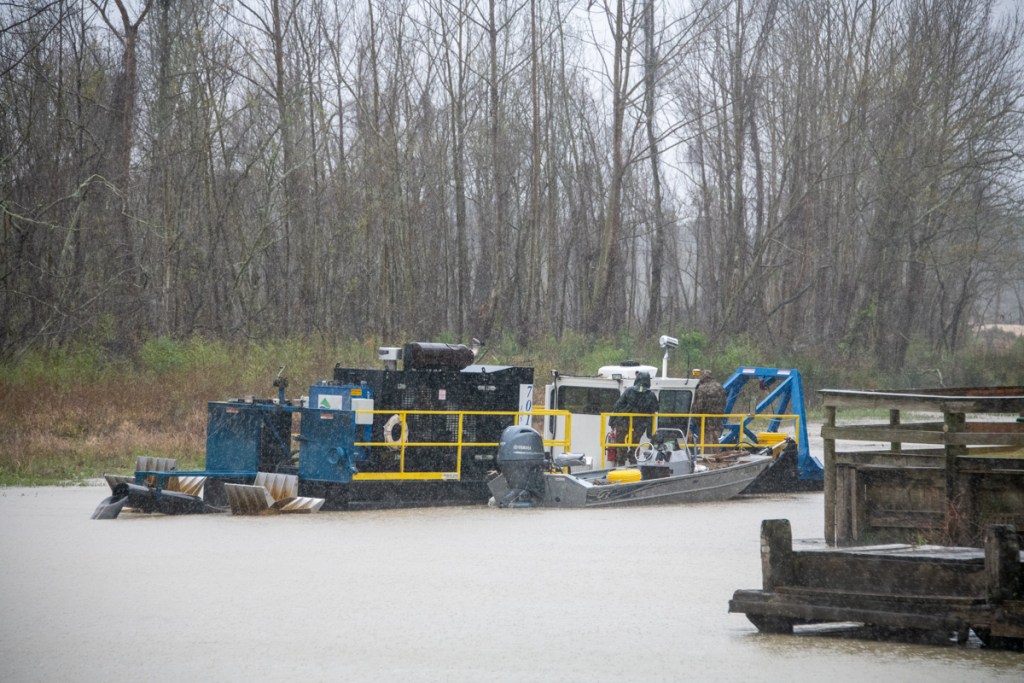
Dredging of the River Grove Park boat launch and lagoon have been set back at least two weeks. Originally, KSA estimated that the job could finish as early as the end of March. According to KSA President Dee Price, that was an estimate from the contractor, Kayden Industries, not a contract requirement.
Lower Lake Level Required Even Smaller Dredge
According to Price, Kayden ran into a problem when the City unexpectedly lowered the level of Lake Houston about two feet. “The reduction in the water level grounded the dredging barge that they were using,” said Price. “To keep moving forward, they removed the first dredge and brought in a smaller one.”
Original dredge now sidelined. Sand stockpile in parking lot is being removed by truck to a location in Humble out of the floodplain.New dredge is even smaller than last one but can operate in shallower water.About one third of the lagoon in front of the boardwalk remains. Note how vegetation is already regrowing on exposed sediment.This afternoon, the new dredge operated by the discharge pipe.The dredge pumps water and sediment into this giant machine that resembles an oil field “shaker.” It separates solids from liquids.The solids drop out. They are then carried to the edge of the boat dock where they dry further before being hauled off.Water minus sediment over a certain size is then returned to the river.
Contractor Will Finish Job With Smaller Dredge
“The water level is back up now,” said Price. “Kayden thinks they can finish the job using the smaller dredge, but it will take a little longer.”
With the corona virus restrictions, there is now very little activity at the park. Reminder: children should NOT use the playground equipment to help restrict the spread of the virus. Soccer leagues have also been affected. Only a handful of people were using the park this afternoon.
After Dredging
The sand pile is still blocking the boat launch. It and Kayden’s equipment will be removed from the park when dredging completes in a couple more weeks.
At that point, KSA intends to repair the asphalt damage from the heavy equipment. KSA will also replace the speed bumps with speed humps to accommodate boat trailers. All that could take till May.
Posted by Bob Rehak on 3/27/2020
941 Days after Hurricane Harvey
https://i0.wp.com/reduceflooding.com/wp-content/uploads/2020/03/20200327-RJR_0438.jpg?fit=1200%2C800&ssl=18001200adminadmin2020-03-27 18:39:572020-03-27 18:40:07River Grove Dredging Completion Delayed at Least 2 Weeks
Since Hurricane Harvey, KSA has worked diligently to restore the damage to River Grove Park. It has been a massive job. Harvey filled in the lagoon in front of the boardwalk; left five feet of sand in the parking lot, disc golf course, and playing fields; and deposited a sand bar more than a quarter mile long and 12 feet high in front of the boat dock.
River Grove Waterfront on 9/14/2017, two weeks after Harvey. Lagoon filled in, five feet of sand filled the parking lot, and a 1400-foot, 12-foot-high sandbar blocked off the drainage ditch that empties the western third of Kingwood.
Army Corps Restored River Access
The Army Corps cut a channel through the sand bar that blocked the drainage ditch that empties the western third of Kingwood. That was a huge sigh of relief for a large part of Kingwood. But much work remained to restore the park itself. Among the last items on the agenda: restoring the lagoon and boat ramp access.
It’s hard to capture the scope of dredging operations from the ground – especially with access restricted for safety reasons. But last week, I did a flyover and captured these pics from a helicopter.
Looking west toward the River Grove Boat Ramp and Lagoon. Photo taken March 5, 2020. The dredge started by the boat dock and is working upstream now in the lagoon. Note the dewatering plant in the parking lot and the growing pile of spoils waiting for removal on the right.
In the photo above, you can see the 50-foot strip where Kayden removed vegetation. That will be the limit of dredging. KSA plans to remove 4-5 feet of sand from this area. The area still covered with grasses will remain wetlands. It will provide cover, habitat and food for birds and other species. That should help make River Grove a destination for birders again.
Harvey deposited sand several feet deep on the peninsula that defines the River Grove lagoon. That unfortunately killed many of the trees there. The wetlands remaining in the lagoon are now more important than ever. Eagles nest in the trees in the upper right of this photo on Romerica property.The dredge started in the area in front of the boat dock and is working its way upstream in the lagoon. Water from the dredge goes through a floating pipe to a dewatering plant in the parking lot. Water is then returned to the lake in a closed-loop process.
A Bit of the Oil Field Comes to River Grove
The dewatering plant separates sand and sediment from the water before returning the water to the river.This is the same type of equipment used in oilfields to separate drilling cuttings from drilling mud, before recycling the mud.
Expected Finish By End of March
KSA expects the dredging project to finish by the end of March, weather permitting. However, the boat ramp may not open immediately. The heavy equipment has damaged the asphalt in the parking lot. Repairs and restriping may take a few weeks more.
Originally, KSA expected to remove 10,000 cubic yards of sediment. The contractor now predicts they will remove 11,000 to12,000 cubic yards to complete the scope of work.
Other Park Improvements
The good news: When all of this is done, River Grove Park should be back and better than ever. During repairs, KSA decided to:
Convert several of the soccer fields from “league fields” to “public fields.” Residents have long requested that change.
Change the speed bumps to milder speed humps in the traffic circle. Boaters have long requested that.
Posted by Bob Rehak on 3/9/2020
923 Days since Hurricane Harvey
https://i0.wp.com/reduceflooding.com/wp-content/uploads/2020/03/20200306-RJR_9605.jpg?fit=1200%2C800&ssl=18001200adminadmin2020-03-09 15:54:072020-03-09 15:57:09New Aerial Photos of River Grove Park Show Extent of Dredging Project
During the first phase of River Grove dredging, the contractor, Kayden, removed vegetation from the area to be dredged adjacent to the boardwalk (see photo below).
River Grove Boat Ramp and Lagoon on 2/13/2020 before dredging operation started. Looking south.
They completed vegation removal last week. They also completed cleaning silt out from under the boardwalk without impacting its stability or support. This week, they’re back with a tiny dredge and a giant mobile dewatering plant.
The Little Dredge That Could
The dredge was selected because it could maneuver in the tight spaces adjacent to the River Grove Boardwalk. It’s 12 feet wide and 51 feet long. The first word that came to mind when I saw it was “cute.” The second thing that came to mind was the child’s story “The Little Engine that Could.” As it sat there chugging away at sand and silt, I thought I could hear the John Deer, 6-cylinder, 13.5 liter diesel engine chanting, “I think I can, I think I can.”
Dewatering Plant Processes Sand for Removal, Returns Water To River
The giant dewatering plant operates much like shakers used in oil field drilling work. Water and sediment are pumped up from the lagoon by the dredge. They enter one side of the dewatering plant. There, they are pumped through centrifuges, then across a series of screens that vibrate. Water falls through the screens into a tank below. Sand accumulates on the screens until they dump it down chutes. From there, a front end loader scoops up the dirt and piles it up until trucks haul it away.
Video of dewatering plant in operation courtesy of Josh Alberson.Front end loader removes dirt from dewatering plant and piles it up for removal from River Grove.
Kayden then pumps the water back into the river.
Water returned to river after sediment removed. Photo courtesy of Josh Alberson.
Dredge Designed for Tight Spaces
River Grove dredging will not move nearly as fast as the dredging that Great Lakes and Callan were doing, but it seems to work well for the location. A major concern is overly aggressive dredging that could undermine the supports for the boardwalk and boat ramp. Another word that comes to mind is “precise.” Think about the difference between a van and an 18 wheeler. The major issue here is fitting in small spaces.
KSA intends to dredge only 50 feet from the boardwalk instead of all the way over to the trees. This shows the area where vegetation was removed earlier. Dredging will take place within this space.
Despite the size of the equipment at River Grove, the operation itself is far more compact than previous dredging operations. This could form a model for the dredging of inlets around the lake, like the one at Walden. However, County Engineer John Blount emphasizes that no decisions have been made in that regard yet.
The Safety Moment
If you take your kids to River Grove to see this operation, make sure you stay behind the yellow tape for your own safety.
Also, until the operation is complete in another month or so, remember that traffic at River Grove will be two-way. Just be aware.
Posted by Bob Rehak on 3/4/2020 with photos and video from Josh Alberson
918 Days after Hurricane Harvey
https://i0.wp.com/reduceflooding.com/wp-content/uploads/2020/03/20200304-RJR_8795.jpg?fit=1200%2C800&ssl=18001200adminadmin2020-03-04 16:56:292020-03-05 09:27:23River Grove Dredging Operation Moves to Next Phase
River Grove dredging has finally begun. Silt and sand deposited by Hurricane Harvey 2.5 years ago is being removed from two areas: the boat launch and boardwalk. KSA obtained a final permit from the City of Houston and equipment arrived yesterday.
Boardwalk First Priority
As you can see from these pictures, the contractor wasted no time. Equipment has already started removing silt from in front of the boardwalk.
Mechanical dredging equipment excavates area near boardwalk.
Additional equipment is being staged from the parking lot.
Contractors closed off the parking lot adjacent to the boat launch for public safety.
Contractors have already started removing the top layer of vegetation adjacent to the boardwalkthat sprouted since Harvey.
Pictures From Immediately After Harvey
A huge sandbar deposited by Hurricane Harvey blocked the Kingwood Diversion Ditch which drains the western third of Kingwood.Note sand covering the parking lot. It was 5 feet deep in places.Taken 9/14/2017.
The lagoon in front of the boardwalk was badly silted in.Taken 9/14/2017.
Pictures Taken February 2020 Before Start of Dredging
Photo taken 2/13/2020 shows how vegetation grew up on silt in lagoon.Aerial photo of boat launch area taken on 1/20/2020 shows that Army Corps opened up the drainage channel to the river. However, the area near the boat launch remains too shallow for most boats to launch safely.
Dredging and cleanup should take about 6 weeks. Completion will make eager boaters and park visitors very happy. River Grove has long been one of the most popular parks in Kingwood.
Posted by Bob Rehak on 2/18/2020
903 Days after Hurricane Harvey
https://i0.wp.com/reduceflooding.com/wp-content/uploads/2020/02/IMG_0480-rotated.jpg?fit=1512%2C2016&ssl=120161512adminadmin2020-02-18 13:05:072020-02-18 13:06:01River Grove Dredging Begins
At its monthly meeting, members of the KSA Parks Committee voted unanimously to approve $60,000 to begin emergency repairs to East End Park immediately. The vote followed a presentation by Bob Rehak (me), Park Steward; Dee Price, KSA President; and Maryanne Fortson, KSA Secretary and President of Fosters Mill.
Safety Concerns Jumpstart Repairs
The presentation detailed damage by Imelda and historic East Fork flooding that put most of the park under water during the tropical storm. Much of the discussion focused on safety concerns following a review of photos taken from land, boat and helicopter, including those below.
Pelican Overlook Trail consumed by erosion from river during Imelda.Same scene from river shows undercut banks. People standing near river could trigger dangerous cave ins.More trail erosion in East End Park. The river migrated approximately 50 feet south consuming large parts of two trails.
The photos (including those above) showed significant bank erosion to the northern shoreline of the park. The river undercut two trails as it migrated south about fifty feet during the storm. Parts of two trails fell into the river: the Pelican Overlook and Eagle Point Trails.
Photos (above) taken from Josh Alberson’s boat show significant undercutting of the shoreline in those areas. That means, someone standing on the edge could trigger a cave in.
KSA has tried to close the park three times, but people keep tearing down the warning signs.
Options Discussed but NOT Included in Emergency Repairs
As part of the discussion on the motion, the Committee examined several alternative solutions to restoring the park to full functionality.
A short new trail (further inland) will reconnect the two parts of the severed Pelican Overlook Trail.
Fallen logs will block off the parts of the existing trail in danger of caving into the river. Metal signs will be screwed into the logs warning people of dangers ahead.
KSA will abandon the Eagle Point Trail and rename it the “Dunes Area” of the park. Residents can still access the Dunes Area, but no trails will run through it. This will reduce current and future repair and maintenance costs; repairing that area consumed a large portion of the budget after Harvey. The dunes should offer a new experience for park-goers, especially those who like climbing or hiking in sand for cardio workouts.
As a separate project (not included in the $60,000), KSA will explore the cost of building a new trail that connects the South Loop and Pelican Overlook trails without going all the way back to the main entry trail. It would go to the south of the “overflow channel” that carries floodwater through that section of the park and would not require bridges.
Also as a separate project, KSA would compare two options for replacing a portion of the South Loop trail. The portion – between Heron’s Rest and the turn-off to the main boardwalk – turns into mud after every flood. The mud comes from several inches of silt deposited on TOP of the crushed granite trail. The first option: relocating the trail atop a berm that parallels the current trail about 50 feet further inland. The second option: replacing the current trail with a low boardwalk, like the ones near Alligator Alley.
Dunes Area Will Revert to Nature
This birds’ nest used to be the height of a basketball hoop. After Imelda, it’s ankle high.Photo by John Knoezer.
Emergency Repairs Will Include…
The Parks Committee appointed Rehak, Fortson and Price as a subcommittee to approve emergency repair costs, rather than wait another month for the Parks Committee to meet again. Included in the emergency repairs:
Tree removal, where necessary
Patching trails scoured by the flood to create a stable hiking and jogging surface
Resurfacing most muddy areas with crushed granite
Boardwalk repairs
Restoring the telephone poles in the parking lot to their original positions
Replacing trail underliner on hills with gravel to create a more stable base for crushed granite. The latter will form the top finished surface.
Erecting barricades and signs warning of hazardous conditions where the river undercut existing trails
Cleaning all boardwalks and benches
Removing all flood debris from trails.
Restoring An Ecological Gem
An estimated 70,000 to 80,000 visitors per year use East End Park. It is an ecological gem, valued as much for the 150 bird species that migrate through the park and a herd of deer that lives in the park year round, as for the quiet, restorative atmosphere that bonds families together on nature walks.
Five area cross country teams also use the park for practice. Joggers value the soft surface of crushed granite. It’s much easier on knees and backs than concrete.
East End Park is also one of the few dog-friendly parks in the City of Houston. Different people like the park for different reasons. It has so much to offer.
I remember one time, seeing a man sitting at a new bench in a particularly beautiful part of the park. He came day after day to walk in beauty and meditate on nature. One day, I asked him what he got out of it. It gave him the motivation, he said, to cope with chemo.
The poster below shows how the park looked then and how it will soon look again.
What East End Park looked like BEFORE Imelda.
Posted by Bob Rehak on 10/3/2019 with gratitude to Josh Alberson, John Knoezer, Dee Price, Maryanne Fortson, National Helicopter Service and the entire KSA Parks Committee
765 Days since Hurricane Harvey and 14 since Imelda
https://i0.wp.com/reduceflooding.com/wp-content/uploads/2019/10/EEP_001_23.jpg?fit=1500%2C1000&ssl=110001500adminadmin2019-10-03 23:50:352019-10-03 23:50:44KSA Approves $60,000 to Begin Emergency Repairs to East End Park Immediately
Thursday night, the Kingwood Service Association (KSA) added its voice to the growing chorus concerned about a proposed high-rise development in the floodplain near River Grove Park. KSA is the largest private group in the Kingwood area. It represents more than 30 community associations, which comprise more than 70,000 residents. It also manages the five private parks in the Kingwood area including two adjacent to the proposed development along Woodland Hills Drive.
The letter addresses concerns that BOTH the TCEQ and Army Corps will consider during the permit evaluation process. TCEQ rules on water quality issues (Clean Water Act Section 401) for the Corps. The Corps rules on Section 404 concerns.
The applicant, Romerica Investments, LLC must respond to every concern submitted by residents. So email them now or forever hold your peace.
Here is the text of KSA’s letter, which is also linked on the High Rise Page in the right hand column. I inserted the pictures and captions into KSA’s letter; they are not part of the original. I put them there to help illustrate the concerns for people who may not be familiar with all of the issues surrounding this controversial development.
Text of KSA Letter
Evaluation Branch, North Unit Regulatory Division, CESWG-RD-E Galveston District U.S. Army Corps of Engineers P.O. Box 1229 Galveston, Texas 77553-1229
Enclosed are the comments of the Kingwood Service Association, regarding the U.S.Army Corps of Engineers (Corps) Galveston District, Section 10/404 proposed Permit Application No. SWG-2016-00384, Romerica Investments, LLC, located in waters of the United States (U.S.) and wetlands adjacent to the West Fork of the San Jacinto River, Kingwood, Harris County, Texas.
The Kingwood Service Association (KSA) is a Kingwood-wide homeowners association representing thirty-two (32) residential and commercial associations in the Kingwood area. The following comments are being made on behalf of Kingwood residents concerned about the impact of the proposed development on the Kingwood community.
KSA owns and operates two parks adjacent to the proposed permit area, River Grove Park and Deer Ridge Park. During Hurricane Harvey, both of these parks flooded with 10 to 20 feet of water. River Grove Park is located on the West Fork of the San Jacinto River between the river and the proposed commercial and residential areas. This park was covered by 20 feet of water. As the flood waters receded, it left 6 feet of sand covering half of the park area. River Grove Park has flooded at least 6 times in the past 12 months. This experience raises serious concerns about the environmental impact of a development that calls for adding fill material to approximately 330 acres located north and east of River Grove Park, and which would raise the grade level of the area 12 feet from 45 feet to 57 feet.
We are very concerned about the overall impact of this development on the community because it would be built where Hurricane Harvey created some of the worst flooding in 100-year or greater floodplains/floodways; will fill and displace about 200 acres of 100-year floodplain/floodway, which will raise water levels and increase the possibility of flooding for others; will fill in wetlands that are crucial for soaking up water and reduced flows, velocities, and increased sedimentation of the West Fork of the San Jacinto River in its 100-year floodplain/floodway; is subject to further flooding in the future; and destroys more of the natural beauty, water quality, and wildlife habitat of the West Fork of the San Jacinto River.
In the review of this permit application, we ask the Corps to consider all relevant public interest review factors in 33 CFR 320-332 including conservation, economics, aesthetics, air quality, general environmental concerns, wetlands, historic properties, fish and wildlife values, flood hazards, floodplain values, land use, recreation, water supply and conservation, water quality, energy needs, safety, food and fiber production, and the needs and general welfare of the people.
We think that, at a minimum, the following areas should be addressed by USACE and TCEQ during the permitting process.
1. This proposal will fill 42.35 acres of wetlands with 68,323 cubic yards of fill material on 331.45 acres and fill 771 linear feet of streams with 285 cubic yards of fill material. There are significant concerns about the environmental impact of the elimination of 42.35 acres of wetlands. These concerns fall into the following areas:
a. Elimination of a natural area inhabited by eagles, deer, and other animals native to the area without sufficient mitigation in the same watershed.
Nesting bald eagles, a protected species, on West Fork of San Jacinto. Photo courtesy of Emily Murphy. The Houston Police Deportment Lake Patrol has reportedly sighted seven other eagle’s nests in the area, according to Murphy who frequently kayaks the river.
b. Decrease in the quality of the water supply for the City of Houston, which is downstream of the development, as a result of the increase in erosion and increase in deposition of sediment caused by the elimination of wetlands and the increase in infrastructure.
One of the drainage ditches that the proposed high-rise development would use is so over-burdened, that incision already is threatening existing development. Any addition to flow would destroy properties.
c. Decrease in the quality of the water supply for the City of Houston caused by the contamination of water run-off by the addition of parking spaces for 8,000 plus vehicles that could increase contaminants, such as motor oil, being washed into the San Jacinto River.
d. Increase of erosion and acceleration of deposition of sediment due to an increase in the speed of water run-off caused by the additional infrastructure, elimination of wetlands, and increase in grade level of the area.
High-rises for the proposed development would fill in wetlands where eagles fish and nest. The high-rises would also be built in an old meander of the San Jacinto West Fork, which contains unstable soil that is prone to flooding.
e. Determine the impact of filling in 42.35 acres of wetlands on eagles nesting in that area. Eagle nests have been spotted in the vicinity by Kingwood residents.
Eagles nest on the 16th hole of Kingwood Country Club’s Island Course, immediately adjacent to the proposed high-rise development.
2. Impact on the ability for residents to use the recreational facilities as a result of the increase in flooding caused by the increase of grade level from 45 feet to 57 feet that would inhibit the flow of water during significant rain events and cause the acceleration of water run-off potentially increasing erosion and accelerating the deposition of sediment in the San Jacinto River.
3. Economic impact on the villages immediately surrounding the development area as a result of the potential increase in flooding caused by the development. This could cause a significant decrease in the value of the homes located in these villages.
4. Economic impact on the community that would be caused by adding 8,000 plus vehicles to the traffic patterns of the community without a plan to mitigate this impact. The increase of this much traffic in a single area would have a negative impact on the attractiveness of purchasing a home in Kingwood, which has a reputation for being the “Liveable Forest”.
5. Completion of an environmental impact study before further consideration of this permit application. This study should include a full hydrological study of the project’s impact, an environmental impact to the large wetlands habitat without mitigation in the same watershed, and socioeconomic impact of such a huge development on an existing master planned community.
6. Impact on boat navigation on the West Fork of the San Jacinto River caused by the potential addition of 640 boats. Navigation on the West Fork has been impaired for decades and getting worse due to the acceleration of sediment deposition caused, in part, by sand mines upstream of the project area. This development has the potential to add to that sediment deposition.
This sand bar is currently not being addressed by the Emergency West Fork Dredging Project. It backs water up throughout the Humble/Kingwood area where thousands of homes and businesses flooded during Harvey. Erosion caused by the new development would add more sediment, make the marina useless, and destroy FEMA’s investment in dredging to date.
7. Require the applicant to provide documentation about how it will provide for operation and maintenance dredging of the site so that Section 10 navigation will continue over the lifetime of the development and after floods.
We are requesting that the Corps schedule a public hearing on this application to allow residents to gather additional information on the proposed development and provide further comments. In addition, considering the potential significant negative impact of this development on the community, we request that the Corps and TCEQ seriously consider denying this permit application.
We appreciate this opportunity to provide public comment on this proposed permit application.
Sincerely, Dee M. Price, President Kingwood Service Association
Feel free to echo these concerns or add to them in your letters to the Army Corps and TCEQ.
Posted by Bob Rehak on 1/19/19
509 Days since Hurricane Harvey
https://i0.wp.com/reduceflooding.com/wp-content/uploads/2019/01/2EaglesInNest.jpg?fit=1200%2C960&ssl=19601200adminadmin2019-01-18 22:53:212019-01-19 11:09:38KSA Adds to Growing Chorus of Concerns Over Proposed New High-Rise Development