
Chances of Tropical Formation in Gulf Increasing for Next Week
9/6/24 – Between yesterday and today, the National Hurricane Center (NHC) increased the chances of tropical formation in the Gulf of Mexico for next week. Yesterday, NHC gave that orange area a 10% chance of development in the next seven days. Earlier this afternoon, they updated that to 40%. And by this evening, they upgraded it again to 50%.
Also, the National Weather Service (NWS) has issued a gale watch for offshore waters tomorrow. And NWS predicts another 4-10 inches of rain for the Houston area next week.
Tropical Activity Heating Up
According to the National Hurricane Center, “A tropical wave located over Belize and the Yucatan Peninsula of Mexico is producing disorganized showers and thunderstorms. The wave is forecast to move into the Bay of Campeche on Saturday, where it could then begin to interact with a frontal boundary. A tropical depression could form during the early or middle part of next week while the system moves slowly northwestward over the southwestern Gulf of Mexico.”

Here’s what those two areas currently look like on a satellite photo.

According to Harris County Meteorologist Jeff Lindner, “A tropical wave currently over the western Caribbean Sea and the surface low over the NW Gulf will merge over the western Gulf going into early next week. As high pressure over the plains moves eastward the steering flow will turn to the south and begin to lift whatever is in the western Gulf northward toward the TX coast.”
Another 4-10 Inches of Rain Predicted for Next Week
Lindner predicts increasing moisture late Monday with a much more significant surge of moisture coming into the area starting on Tuesday. Regardless of tropical formation, rains will spread northward from the Gulf into the Houston area. Heavy rainfall looks possible into the middle of next week.
The National Weather Service predicts accumulations in the next seven days could range from 4-10 inches in the Houston region. The larger accumulations will be near the coast. Rainfall totals offshore could range up to 20 inches!

We’ve already achieved our average rainfall for the year. Yet we have almost 4 months yet to go.

High Winds, Gale Watch Saturday
The National Weather Service has issued a gale watch for Saturday morning through evening as high pressure pushes the moisture currently over us to the south and then east.
Ironically, this will usher in drier weather for Sunday, but it will make boating dangerous on Saturday. North winds will average 25-35 knots with gusts to 40 knots. Seas will average 9-11 feet.

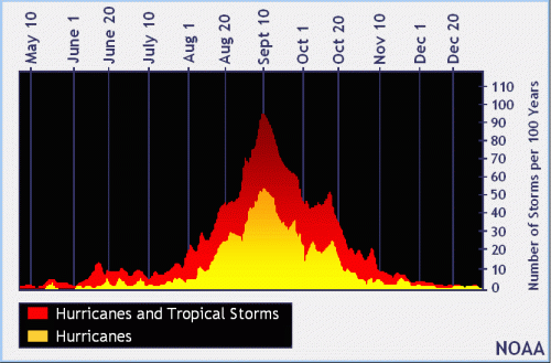
Peak of Hurricane Season Just Days Away
Earlier this year, experts predicted an extremely active hurricane season in the Atlantic Basin. But so far, we’ve had only five named storms.
| Storm | Dates | Max Wind (mph) |
| Tropical Storm Alberto | 19-20 June | 50 |
| Major Hurricane Beryl | 28 June to 9 July | 165 |
| Tropical Storm Chris | 30 June to 1 July | 45 |
| Hurricane Debby | 3-9 August | 80 |
| Hurricane Ernesto | 12-20 August | 100 |
That puts us three behind the average for the last 30 years. Usually, we get the eighth named storm of the season by September 9th.
And the peak of hurricane season occurs on September 10 with the most activity occurring between mid-August and mid-October.
Best to bookmark the National Hurricane Center home page and check it daily for the next few weeks. This is the time of year when NHC updates its site every few hours. So, they have the most up-to-date forecasts and they are the acknowledged source of definitive information about tropical systems.
Posted by Bob Rehak on 9/6/2024
2565 Days since Hurricane Harvey

