Tag Archive for: Alberto

Alberto, First Named Storm of Season, Lashes Mexico, South TX

6/19/24 – Potential Tropical Cyclone #1 just became Tropical Storm Alberto, according to the National Hurricane Center’s (NHC) 10 AM update. Alberto will reach the coast of northeast Mexico early tomorrow morning.

Texas Impacts from Alberto

Until then, the entire Texas Coast up to San Luis Pass is under a tropical storm warning. Residents can expect heavy rains, coastal flooding and gusty winds through Thursday.

NHC expects Alberto to weaken quickly once it comes ashore early Thursday. The storm is moving at 9 miles per hour with maximum sustained winds of 40 MPH. Tropical-storm-force winds extend outward up to 415 miles north of the center.

Peak storm surge will reach 2-4 feet along the upper Texas Coast and Galveston Bay.

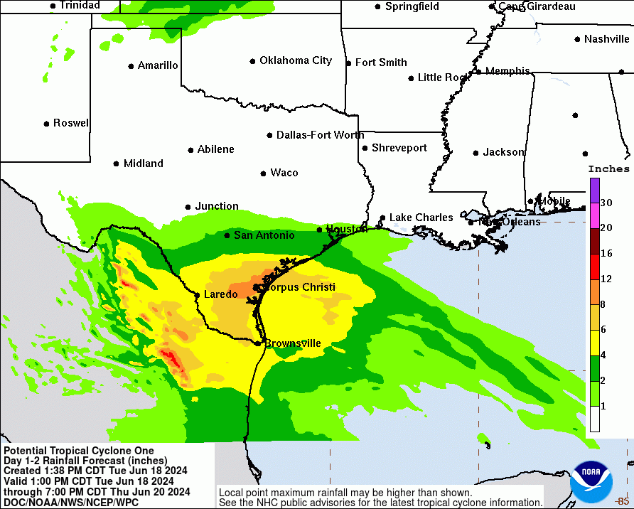
Rainfall Still Ratcheting Down

Rainfall predictions continue to ratchet down, however, especially for the Houston area as Alberto is pushed south by higher pressure from the northeast U.S.

Alberto should produce 5 to 10 inches of rainfall across northeast Mexico into South Texas. Maximum totals around 20 inches are possible. This rainfall will likely produce considerable flash and urban flooding along with new and renewed river flooding.

NHC will produce more advisories on Alberto at 1 and 4 PM today.

Make Alberto a Learning Experience

If you have kids home from school looking for something to do, this is an excellent chance to teach them about tropical cyclones.

NHC offers dozens of educational resources geared toward students from K-12 all the way up to continuing education for weather professionals. Harness your child’s natural curiosity while storms are in the news.

I found NHC’s course on Hurricane Basics very informative. Before Alberto became Alberto, it had winds strong enough to qualify as a tropical storm, but NHC kept calling it a potential tropical cyclone instead. Do you know the other attributes that define tropical cyclones? Hurricane Basics tells you.

Want to know what it takes to get a tropical cyclone started?

What affects their intensity?

Or how various factors come together to produce more or less rainfall?

NHC describes each of the factors above and provides clear, simple illustrations that make them easy to understand.

This particular presentation also covers:

  • Storm tracks
  • Where hurricanes will most likely form depending on month of the season
  • Tropical distrubances
  • Track forecasting
  • Associated hazards, such as hurricanes
  • Relative risks from wind, rainfall, surge, flash flooding, etc.
  • Categories of storms and types of damage associated with each
  • More, much more.

Trivia: By the way, NHC provides climate data, too. Did you know, for instance, that the first named storm of the season usually occurs on June 20th in the Atlantic Basin. This year, the first named storm occurred on June 19.

Posted by Bob Rehak on 6/19/24

2486 Days since Hurricane Harvey

Heaviest Rainfall Threat from PTC1 Shifting Southwest

The heavy rainfall threat for the northeast Houston area from PTC1 (Potential Tropical Cyclone #1) has shifted southwest somewhat today. While the storm takes its time getting organized, high pressure from the eastern US is building into the Houston area. That’s squeezing the heaviest rains toward the coast and the Rio Grande Valley.

Meanwhile, the National Hurricane Center warns of a second storm forming next week exactly where PTC1 is forming now. But it will likely head north, not west.

Heaviest Rainfall from PCT1 Shifting Southwest

Over the weekend, early predictions suggested heavy rains would arrive in the Lake Houston Area on Monday. Monday’s predictions suggested Tuesday. And now Tuesday’s predictions say the Lake Houston Area might get 1-3 inches of rain during the next three days.

The National Weather Service (NWS) now predicts PTC1 will produce rainfall totals of 5 to 10 inches across northeast Mexico into South Texas. Maximum totals could approach 15 inches.

This rainfall will likely produce flash and urban flooding along with new and renewed river flooding.

NWS also predicts the broad circulation of PTC1 could produce extreme rainfall in Central America. Totals could average 10 to 20 inches with maximum amounts of 25 inches. Areas most affected include the Pacific coast of far southern Mexico, southern Guatemala, much of El Salvador, western Honduras, and far western Nicaragua.

Here’s what the storm looked like earlier today from space.

Landfall in Mexico

As of 4PM CDT Tuesday, NWS predicted PTC1 would make landfall in Mexico sometime within the next 24 to 36 hours as a tropical storm. They currently give it an 80% chance of formation.

At present, the storm exhibits wind speeds approaching tropical storm strength (39+ MPH). Tropical storm conditions could begin tonight or Wednesday along portions of the Texas coast south of San Luis Pass.

Tropical storm force winds extend outward 415 miles north of the center.

National Hurricane Center

So focus less on the track and more on the impact.

The National Hurricane Center (NHC) warns, “Regardless of the exact track of the low, this system will have a large area of heavy rains. Expect moderate coastal flooding and tropical-storm-force winds well north of the center.”

Moderate coastal flooding is likely along much of the Texas Coast through midweek.

If PTC1 becomes a tropical storm, its name will be Alberto.

Double Trouble?

NHC’s website showed something unusual today. One possible tropical system could develop within the area vacated by another. Within days of each other!

NHC gives a 20% chance of the second storm developing in the yellow area with the red X.

But instead of moving into Mexico, they predict the second storm could move northward. That could make it a direct threat to Houston.

So check NHC’s weather forecasts daily during hurricane season. As PTC1 proves, weather can change quickly.

Posted by Bob Rehak on 6/18/24

2485 Days since Hurricane Harvey